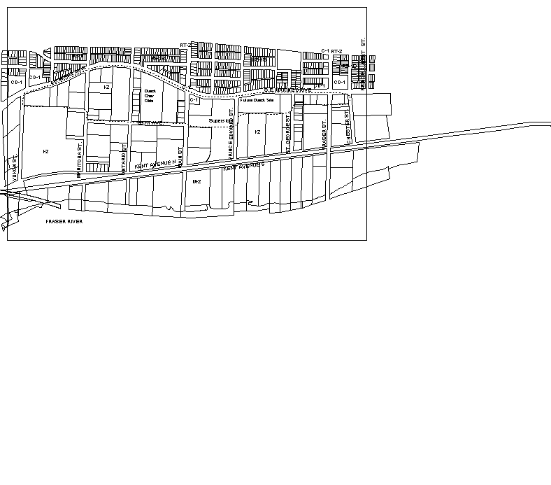
 Figure 1: Marine Drive Study Area
Supports Item No. 2
P&E Committee Agenda
May 10, 2001
POLICY REPORT
URBAN STRUCTURE
Date: April 24, 2001
Author/Local: HBurpee/BVerde 6068
RTS No.01914
CC File No. 5317
P&E: May 10, 2001
TO: |
Standing Committee on Planning and Environment |
FROM: |
The Director of CityPlans in consultation with the General Manager of Engineering Services |
SUBJECT: |
Guidelines for Highway-Oriented Retail (HOR) and Institutional, Cultural, and Recreational Uses in the Marine Drive Industrial Area |
RECOMMENDATIONS AND CONSIDERATIONS
A(i). THAT Council adopt the Highway-Oriented Retail Rezoning Policies and Guidelines: Marine Drive Industrial Area, included in Appendix A;
OR FOR CONSIDERATION
A(ii). THAT Council adopt the Highway-Oriented Retail Rezoning Policies and Guidelines: Marine Drive Industrial Area, with references to Food and Clothing Retail removed.
B. THAT Council adopt the I-2 Institutional, Cultural, and Recreational Uses Guidelines for Conditional Approvals: Marine Drive Industrial Area, included in Appendix B.
C. THAT for privately initiated applications for rezoning or conditional uses, agreements for the provision of on-site and adjacent off-site engineering services (e.g., sewer, water, roads, and traffic improvements) be required as a condition of approval.
D. THAT the City-wide Vancouver Development Cost Levy (DCL) By-law rate (currently $2.50 per sq.ft.) for new construction and additions of commercial and retail uses apply to CD-1 rezonings for Highway-Oriented Retail in the Marine Drive Industrial Area.
E. THAT Schedule B, Section 1(d)(ii)(E) of the Sign By-law be amended to include any CD-1 zones in the Marine Drive HOR area, thereby not permitting billboards on these sites.
F(i). THAT Council approve the boundary for the Marine Drive HOR area as shown on Figure 2, generally to include the area between Yukon and Main Streets and north of 69th Avenue;
OR FOR CONSIDERATION
F(ii). THAT Council approve the boundary for the Marine Drive HOR area to include the Marine Drive frontage between Yukon and Prince Edward Streets and north of 69th Avenue.
GENERAL MANAGER'S COMMENTS
The General Manager of Community Services RECOMMENDS approval of A(i), and B through F(i), and submits A(ii) and F(ii) for Council's CONSIDERATION.
COUNCIL POLICY
In June 1995, Council adopted CityPlan which provides for the development and reinforcing of neighbourhood centres, a diverse economy and jobs close to home.
In March 1995, Council adopted the Industrial Lands Policies, intended to retain most of the City's existing industrial land for industrial and city-serving activities. Council requested staff to investigate mixed retail/industrial zones along Grandview Highway and Marine Drive. In July 1999, Council adopted Highway Oriented Retail (HOR) Interim Rezoning Policies and Guidelines: Grandview/Boundary Industrial Area.
In November 1996, Council approved the new I-2 district schedule as an implementation measure for the Industrial Lands Strategy to better accommodate the needs of contemporary industry and ensure compatibility with adjoining residential areas.
In July 1998, Council adopted the Kensington Cedar Cottage and Dunbar Community Visions which call for no additional big box stores in KCC or Dunbar, or close enough to threaten the economic health of local shopping areas.
In January 1999, Council approved the Vancouver Development Cost Levy By-law #8149, which took effect January 28, 2000. DCL rates for development in the City are: $2.50 per sq. ft. ($26.91/m²) for most uses (e.g., commercial, residential); $1.00 per sq. ft. ($10.76/m²) for non-residential uses in industrial zones; and, $0.51 per sq. ft. ($5.49/m²) for daycare or school use.
SUMMARY AND PURPOSE
Council's Industrial Lands Policies call for stabilizing the City's remaining industrial land through measures such as the I-2 District Schedule and establishing locations for Highway-Oriented Retail (HOR) and Institutional, Cultural, and Recreational uses along Grandview Highway and Marine Drive frontages.
Providing limited opportunities for large scale retail uses in designated HOR areas and for various non-industrial uses, conditionally approvable under the I-2 District Schedule, will reduce pressure to convert other industrial land. It will also satisfy some of the demand for uses that are car-dependent, require `highway frontage', and cannot easily locate in local commercial areas and neighbourhood centres.
The idea behind HOR was to provide a location for infrequent retail purchases, such as furniture stores, which require larger floor plates than typically found in local shopping areas. However, the pre-existence of food and clothing stores along Grandview Highway prompted staff to recommend permitting these uses subject to retail and traffic impact studies. This provided Council with the opportunity to consider each use on a site by site basis. In July 1999, Council adopted guidelines for HOR and educational, cultural, recreational and institutional uses in the Grandview/Boundary Industrial Area.
This report provides two options for HOR uses permitted in the Marine Drive area. Recommendation A(i) provides for the same mix of uses along Marine Drive as in Grandview/Boundary, again subject to retail and traffic impact studies. However, staff note that some different circumstances exist in the Marine Drive HOR area. These include emerging Vision Directions in the Sunset and Victoria/Fraserview/Killarney areas to not support big box uses which may impact local centres. Staff have not done a detailed analysis of possible impacts of food and clothing big box uses on nearby Fraser and Main shopping areas. However, given the emerging Vision Directions, staff offer for consideration A(ii) which would exclude food and clothing retail from the Marine Drive HOR area.
This report proposes locations for HOR and Institutional, Cultural, and Recreation uses for the area north of 69th Avenue between Yukon and Main Streets as shown in Figure 2 and recommended in F(i). An optional boundary to extend east to Prince Edward Street to include the Real Canadian Superstore is submitted for consideration as F(ii).
If approved by Council, HOR guidelines in Appendix A will be used by applicants and staff in evaluating owner initiated CD-1 rezoning applications. HOR could be considered in addition to uses currently permitted under the I-2 industrial zoning. Institutional, cultural and recreational uses could also be considered, in accordance with guidelines in Appendix B.
BACKGROUND
Figure 1: Marine Drive Study Area
The Marine Drive HOR study area extends from Yukon Street to Chester Street (see Figure 1) It is mostly zoned I-2, which permits light industry and ancillary retail and office uses. I-2 also allows institutional, cultural, and recreational uses such as clubs, theatres, churches and schools through conditional approval.
The Industrial Lands Policies also identified the Marine Drive frontage west to Laurel Street as potential HOR. However, on review, the area west of Yukon includes smaller lots with stable residential development and institutional uses such as ICBC. In addition, traffic, parking and circulation impacts on residents, and difficult site access caused by congestion from the Oak Street Bridge off-ramp make HOR west of Yukon problematic. This area is not included in this HOR proposal.
Marine Drive is home to numerous retail uses, ranging from car dealerships to antique furniture, paint stores and a Superstore. Car dealerships are permitted in I-2 but other stand-alone retail uses are not. I-2 permits retail that is ancillary to industrial uses, if the retail portion does not exceed 1000 m² (10,760 sq.ft.) and one-third of the total floor area.
Larger sites are located between Yukon and Main Streets, while the area east to St. George Street is occupied by existing HOR type uses including Superstore, Brown Brothers Ford and the future Dueck site. The area from St. George to Chester generally consists of smaller lots developed with service and retail uses. The Great Canadian Casino will be relocated to 69th Avenue and Ontario Street.
Beyond the study area, north of Marine Drive is mostly single family houses which overlook the industrial area and Fraser River. The I-2 area between 69th and Kent Avenues is a well-established light industrial area. South of Kent Avenue to the Fraser River is zoned M-2 heavy industry. Existing marine-oriented uses include sawmills and an asphalt plant.
Marine Drive is one of the city's busiest arterials and truck routes. It carries about 60,000 vehicles per day and is an important route for crosstown traffic, linking three bridges and regional destinations such as the airport and UBC.
Ontario Street is a designated City Greenway/bikeway and has been traffic calmed north of Marine Drive. The Greenways Plan proposes an east-west bikeway along Kent Avenue from Ontario to Boundary Road.
DISCUSSION
HOR Objectives
This proposal is intended to accommodate limited opportunities for large scale retail uses in the City. It is not intended to satisfy all potential demand. To prevent further erosion of industrial land in the area, a firm boundary is proposed along 69th Avenue between the HOR area and industry to the south. The HOR area is also suitable for institutional, cultural and recreational uses which generally require larger lots and have parking needs that can impact neighbourhood areas and compete for industrial sites.
Public Consultation
Staff met with Marine Drive industrial interests, property owners and local residents at three open houses. Two were held in September 2000 to get feedback on directions for the HOR area. The third was held in March 2001 to gain input on draft policies and guidelines. Key messages from the public focussed on the proposed boundary, traffic concerns, impacts onretail viability in existing commercial areas and the aesthetics of big box retail. Appendix C details these comments.
HOR Policies for Marine Drive
Policies and guidelines included in Appendix A are proposed to guide CD-1 rezonings for HOR along Marine Drive. Many are similar to those approved for the Grandview/Boundary area, as outlined below.
Density and Height
A maximum FSR of 0.6 would be allowed for HOR, subject to appropriate site access and managing traffic impacts, landscaping, and urban design. A minimum single-tenant size of 929 m² (10,000 sq.ft.) is proposed. This will prevent general retail or a shopping mall which could compete directly with neighbourhood centres.
HOR would be considered in addition to the current I-2 provisions. The current I-2 maximum FSR of 3.0 would still be available through mixed-used development ( retail up to 0.6 FSR and additional I-2 up to 2.4 FSR). Ancillary retail will continue to be permitted under I-2. For example, clothing manufacturers or wholesalers could sell clothing as long as the retail portion does not exceed the maximum permitted in the I-2 District Schedule. If it does, rezoning to CD-1 for HOR would be required.
Staff propose a height limit of 12.1 m (40 ft.), as in Grandview/Boundary, which is typical single storey development with high ceilings. Building height would be conditionally relaxable to 18.3 m (60 ft.) for mixed-use development.
Appendix E summarizes zoning proposals under the HOR Guidelines.
Traffic Management
Mitigating traffic impacts was an important message from the public consultation. The potential for HOR to increase traffic congestion and safety problems on Marine Drive was a key concern of residents and some industrial representatives.
Given that HOR must respond to Marine Drive's primary transportation function, rezoning applicants will need to undertake a traffic impact study for large scale retail proposals. This would examine impacts and identify traffic management measures. Rezoning applicants will be required to pay for measures such as a left turn bays or traffic signals.
Urban Design
New HOR development can, over time, help improve the urban design character and environment for Marine Drive and flanking streets. Policies and guidelines that will assist in achieving a more positive streetscape and area image include the following elements.
· Setbacks
The 12.1 m (40 ft.) front yard landscaped setback established for most of Marine Drive, would be maintained for HOR developments. This will help create a pleasant streetscape and buffer residences across Marine Drive. The setback would be free of parking areas and signs. Uses would be limited to vehicular and pedestrian access.
A few residents were concerned about enforcement of the landscaped setback on Marine Drive. Some businesses use the setback for parking or product display. Enforcement has been difficult because of by-law wording concerns. The HOR setback should be enforceable because the guidelines would require the landscaped setback as a condition of rezoning.
Provisions for cyclists and pedestrians will be incorporated into HOR projects to create safe links across Marine Drive to the planned Kent Avenue bikeway and recreational spaces along the river. Staff propose a 1 m (3 ft.) side yard setback for sites adjacent to Yukon, Manitoba, Ontario and Main Streets. This and the grass boulevard next to the curb would be planted to achieve a staggered double row of trees.
· Building Design
Buildings would directly front the landscape setback for at least 50 percent of the Marine Drive site frontage to provide a presence on the street. Continuous blank walls would be discouraged and building forms broken up to reduce scale. Roofs and rooftop mechanical equipment would be well-designed and screened from overlook from residences to the north.
· Signs
To achieve urban design and landscaped setback objectives, staff propose that billboards not be permitted anywhere on Marine Drive HOR sites. These sites would be added to the list of CD-1s in which billboards are prohibited in Schedule B of the Sign By-law.
Parking
HOR parking requirements would be consistent with those for Grocery Stores in the Parking By-law. Where the use is furniture or similar retail which generates less traffic, the City may apply a lower commercial parking standard.
Parking areas would be located to the side or rear of the building(s). Loading would not be visible from the fronting street. Parking areas would include frequent tree and planting islands to visually relieve large paved areas and provide shade in summer.
Use on 69th Avenue
To minimize impact on industry to the south, HOR activities and uses on 69th Avenue would complement the adjacent industrial use (e.g., loading, storage, warehousing etc).
Institutional, Cultural and Recreational Uses
As in Grandview/Boundary, institutional, cultural and recreational uses would be considered in the Marine Drive HOR area. While conditionally permitted in I-2, applications are often refused because of impacts on adjacent industrial uses.
These uses are similar to HOR as they serve a large area, benefit from an arterial location, may have significant traffic impacts and often cannot find a large enough site in commercial or residential areas (e.g., churches, halls, funeral parlours, hockey rinks). The HOR area will provide limited opportunities for these uses and could offer a good fit where nearby HOR uses have different peak parking demands. Guidelines are included in Appendix B.
HOR Issues - Uses and Area on Marine Drive
In establishing HOR policies for the Marine Drive area, two issues need to be addressed: (1) the type of goods sold, and (2) the extent of the HOR area.
1. Types of Goods: Food and Clothing
Two options are presented for retail uses permitted in the Marine Drive HOR area:
· A(i) - permits large scale food and clothing retail; or
· A(ii) - excludes large scale food and clothing retail.
HOR was originally intended to provide limited opportunities for large retail uses with the following characteristics:
· big-box outlets that because of the nature of the product, require large sites (e.g., large display areas needed, bulky goods, such as furniture and flooring);
· shopping generally requiring the use of a vehicle;
· large scale retail outlets that would impact neighbourhood centres if located there due to scale and/or traffic impacts;
· retail outlets that sell goods not conveniently available in neighbourhood centres or other commercial areas; and
· retail uses like auto dealerships which can free up local commercial areas for more pedestrian-oriented, smaller-scale retailing.
The initial intent of HOR was not to permit food and clothing uses which might draw from established shopping areas. This was in line with CityPlan policies to encourage neighbourhood centres to provide a full range of goods for nearby residents.
However, the pre-existence of food and clothing stores along Grandview Highway prompted staff to recommend permitting these uses, subject to retail and traffic studies to assess the impacts of competition on neighbourhood centres and other shopping areas. This provided Council with the opportunity to consider each use on a site-by-site basis. Since sites are generally smaller in Grandview/Boundary and rezoning applications so far have been for reuse of buildings and regularizing existing retail uses, significant new impacts are not expected. For consistency, Option A(i) provides for the same mix of uses in the Marine Drive HOR, again subject to retail and traffic impact studies.
However, staff note that some different circumstances exist in the Marine Drive HOR area. The Marine Drive area has large lots and significant potential for new HOR. Big box food and clothing stores have large trade areas, attracting shoppers from up to a 15 to 20 minute drive away. Marine Drive HOR could impact neighbourhood centres in the Sunset and Victoria/Fraserview/Killarney Vision areas since they are close to Marine Drive.
In the context of this study staff have not been able to undertake an extensive, quantitative analysis of the possible impacts of new food and clothing stores in the Marine Drive HOR area. We do, however, have some public opinion about this issue, from consultation on the HOR proposal
(Appendix C) and the CityPlan Neighbourhood Visioning program.
Much of the proposed Marine Drive HOR area is located in the Sunset community where local residents are engaged in the Sunset Community Vision Program. The process has included issue workshops where concerns were raised that big box outlets which sell groceries, clothing and other daily needs, should not be permitted to locate where they will harm the economic health of the Fraser and Main Street shopping areas. Ideas and directions from the community workshops, including the question of big box retail, will be included in a survey to be delivered in May to all residents. The results, if endorsed by Council, will become the Community Vision for the neighbourhood.
Council has two choices.
· Recommendation A(i) permits rezoning applications for food and clothing uses in the Marine Drive HOR area. This is consistent with Grandview/Boundary HOR policy. Inaddition it offers opportunities for firms who have, to date, not established illegal retail uses in industrial areas to apply to rezone to permit development. Rather than attempting to prejudge uses, in the absence of a market study, A(i) provides applicants with the opportunity to make a site-by-site case subject to the results of retail and traffic studies. Council can consider these studies and hear delegations at Public Hearing on what would constitute an acceptable/unacceptable impact on neighbourhood centres and local traffic.
On balance, and given the absence of detailed analytical information about impacts, staff recommend this option. However, to ensure that the retail study is rigorous and impartial, staff propose that it be paid for by the applicant but that staff set the terms of reference and hire the consultant. The consultant would review cumulative impacts together with those from the specific proposal.
· Consideration A(ii) offers Council the option of concluding, based on public input from Visioning, that food and clothing retail uses are not appropriate along Marine Drive as they may risk CityPlan initiatives to nurture and reinforce neighbourhood centres. As well, Council may be unwilling to accept potential traffic impacts on Marine Drive and nearby bridgeheads. This choice is submitted for consideration.
2. Extent of the HOR Area
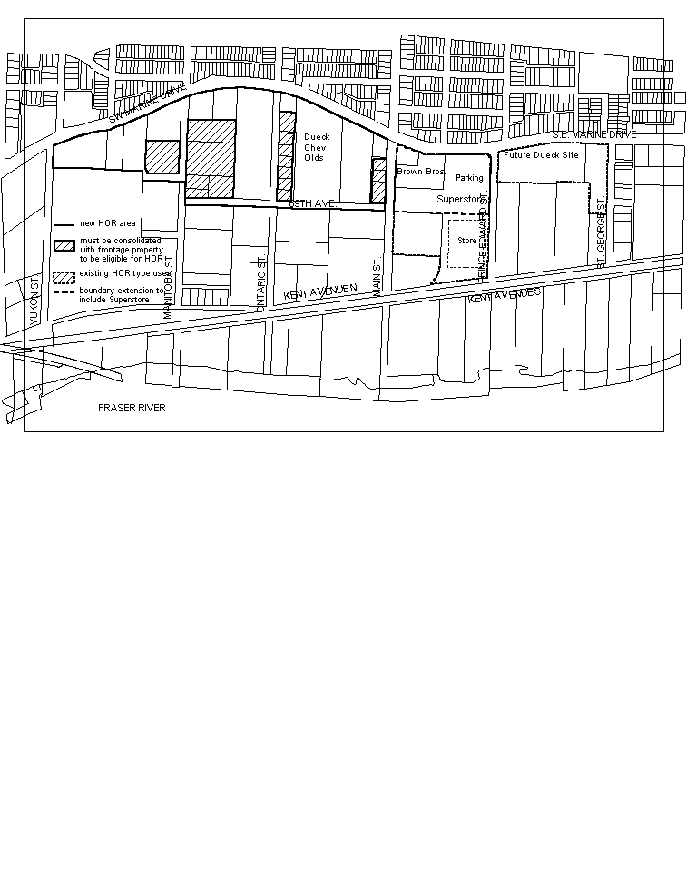
Figure 2: Proposed Marine Drive HOR Boundary
The HOR boundary generated significant discussion in the public consultation:
· Some industrial owners outside of the study area shown in Figure 1 wanted to be included in HOR;
· Some small site owners east of Main felt there were more options for smaller retail under the current I-2 zoning than in HOR. Others wanted to be included in the area;
· Some industrial businesses and tenants worried that HOR could increase property values and impact their viability and wanted to limit the area;
· Some residents felt there were already too many businesses along Marine Drive and that HOR big box could be an eyesore; and
· Superstore, an existing HOR use, wanted to be included in the HOR area.
In September 2000, staff took an area extending from Yukon to Chester Street out for public review (see Appendix D). There was considerable discussion about the extent and depth of the frontage. Based on comments like those above and further staff review, a revised boundary was taken out to a second round of consultation in March, 2001 (see Appendix D). There was a range of opinion, with a general consensus that the southern boundary should be 69th Avenue provided that all sites achieve frontage on Marine Drive. There was less agreement on the eastern boundary. Given this range of opinion and staff concerns about the extent of the HOR area, two options for the boundary are presented.
Recommendation F(i) - HOR area Yukon to Main Street
Staff recommend that HOR be considered between Marine Drive, 69th Avenue, Yukon and Main Streets (see Figure 2). Hatched sites within this area would be eligible for HOR if consolidated with a site fronting onto Marine Drive. Reasons include:
· encroachment into the industrial area south of 69th Avenue could impact viability and industrial traffic associated with heavy industry south of Kent;
· extending the boundary further east could create congestion back-ups at the Knight Street Bridge head;
· the area between St. George and Chester Streets is an established service/retail area with uses permitted in I-2 (e.g., gas stations, restaurants). Many sites would require consolidation to achieve minimum HOR size and parking requirements. The ownership pattern and lack of lane access are obstacles to consolidation and efficient servicing for HOR; and
· the hatched properties east of Main Street including Brown Brothers Ford, Superstore, Marine Plymouth Chrysler and the future Dueck site are existing HOR type uses. Auto dealerships are permitted under I-2; Superstore is not.
Consideration F(ii) - Expand the HOR area from Yukon to Prince Edward
Superstore is a legal non-conforming use in I-2, approved under the old M-1 zoning, where retail was permitted up to one-third of total floor area. Superstore has 11,148 m² (120,000 sq.ft.) of retail space. The current I-2 retail maximum is 929 m² (10,000 sq.ft).
Westfair Properties, the owner of Superstore, wants the same HOR opportunities as sites west of Main. They would like to bring site development into zoning conformity and provide for future additions to the store. Inclusion in the HOR area and successful rezoning would meet Westfair's needs.
As shown in Figure 2, this option would include the portion of the Superstore site north of the alignment of 69th Avenue, where parking for the existing store is located. Westfair has indicated they wish to add 2,300 m² (25,000 sq.ft.). However, under HOR, they could potentially build another 17, 600 m² (190,000 sq.ft.) of retail, subject to meeting guidelines, parking and submitting traffic and retail impact studies. This could more than double the existing retail development on this site.
Including the store in the HOR area may lead to unrealistic expectations of the amount of development which will be considered. Irrespective of whether Superstore is included in the HOR area, Westfair has the right to apply for CD-1 rezoning tailored to their specific requirements. This would enable them to regularize their zoning and seek additional building area. Since the existing Superstore is located south of the alignment of 69th Avenue and the site extends from Marine Drive to Kent Avenue, inclusion in the HOR area might create a precedent for other owners of sites located south of 69th to seek rezoning to HOR. This would result in further encroachment on industrial land. For these reasons, staff do not support the expansion of the HOR area to Prince Edward but offer F(ii) for Consideration.
Amenity and Infrastructure Contributions
Pursuant to Council's resolution of April 13, 1999, no CACs will be collected for HOR rezonings. This reflects the current interim city-wide CAC policy that no CAC is charged if the total allowable FSR is not increased through rezoning. Infrastructure and street improvements to accommodate HOR will be secured through conditions of rezoning approval.
Unless otherwise specified, uses in a CD-1 Schedule are required to pay the city-wide rate applicable to commercial, retail, and most other uses (currently $2.50 per square foot). Staff believe this rate is appropriate for HOR uses since it treats HOR retail uses the same as retail uses in other commercial districts.
Under the existing interim city-wide DCL policy, uses in an I-2 district, including conditional uses such as institutional, cultural, and recreational uses, are charged the industrial DCL rate (currently $1.00 per square foot). This policy is under study as part of the City's Financing Growth Review.
CONCLUSION
Providing some limited opportunities for HOR, Institutional, Cultural, and Recreational uses along Marine Drive will assist in stabilizing the remaining industrial land in the Marine Drive area for industrial uses as well as supply a location for uses that are not suitable for local commercial areas and neighbourhood centres.
HOR is proposed for a portion of the Marine Drive Industrial area. An optional boundary to include Superstore is submitted for consideration. Also included for consideration is the option to not consider large scale food and clothing retail in the Marine Drive HOR area given the potential impacts on neighbourhood centres.
LINK TO APPENDIX C
LINK TO APPENDIX D
* * * * *