 City of Vancouver Land Use and Development Policies and Guidelines
Community Services, 453 W. 12th Ave Vancouver, BC V5Y 1V4 _ 604.873.7344 fax 873.7060
[email protected]
City of Vancouver Land Use and Development Policies and Guidelines
Community Services, 453 W. 12th Ave Vancouver, BC V5Y 1V4 _ 604.873.7344 fax 873.7060
[email protected]
APPENDIX A
DRAFT
HIGHWAY ORIENTED RETAIL (HOR)
REZONING POLICIES AND GUIDELINES:
MARINE DRIVE INDUSTRIAL AREA
CONTENTS
Page
Application and Intent 1
1 Rezoning Criteria 2
1.1 Retail Uses and Impact on Neighbourhood Centres 2
1.2 Floor Space Ratio 2
1.3 Height 2
1.4 Marine Drive Frontage 2
1.5 Setbacks and Side Yards 2
1.6 Impact on 69th Avenue 3
1.7 Traffic, Parking and Access 3
1.8 Landscape 3
1.9 Design Guidelines 3
2 Site Considerations 3
2.1 Topography: Adjustments to Grade 3
3 Vehicular Access, Off-Street Parking, and Loading Areas 3
3.1 Parking Facilities 3
3.2 Shared Driveways to Reduce Curb Cuts and Impervious Surfaces 4
3.3 Landscaping and Screening of Parking and Loading Facilities 4
3.4 Loading Areas 4
4 Public Realm and Streetscape 5
4.1 General Provisions 5
4.2 Public Realm and Streetscape on Marine Drive 5
4.3 Public Realm and Streetscape on North-South Streets 6
5 Architectural Characteristics 9
5.1 Height 9
5.2 Building Width and Depth 9
5.3 Massing and Form 9
5.4 Main Entries to Street 9
5.5 Building Articulation 9
5.6 Weather Protection 11
5.7 Transparency 11
5.8 Exterior Materials 11
6 Open Space, City Greenway and Bikeway 12
7 Outdoor Storage and Display Areas 12
8 Signage and Lighting 12
9 Environmental Considerations 14
9.1 Trees and Vegetation: Retention, Relocation and Replacement 14
9.2 Water: Surface and Groundwater Protection 14
9.3 Soils: Retention, Cleansing and Replacement 14
9.4 Air Quality and Transportation: Proximity and Land Use 14
9.5 Energy: Conservation and Efficiency 14
9.6 Solid Waste: Reuse and Recycle 14
10 Public Benefits and Infrastructure 15
Note: These policies and guidelines should be used by applicants in order to prepare their applications, and will be used by City of Vancouver staff in evaluating CD-1 rezoning applications for highway oriented retail in the subject area.
Application and Intent
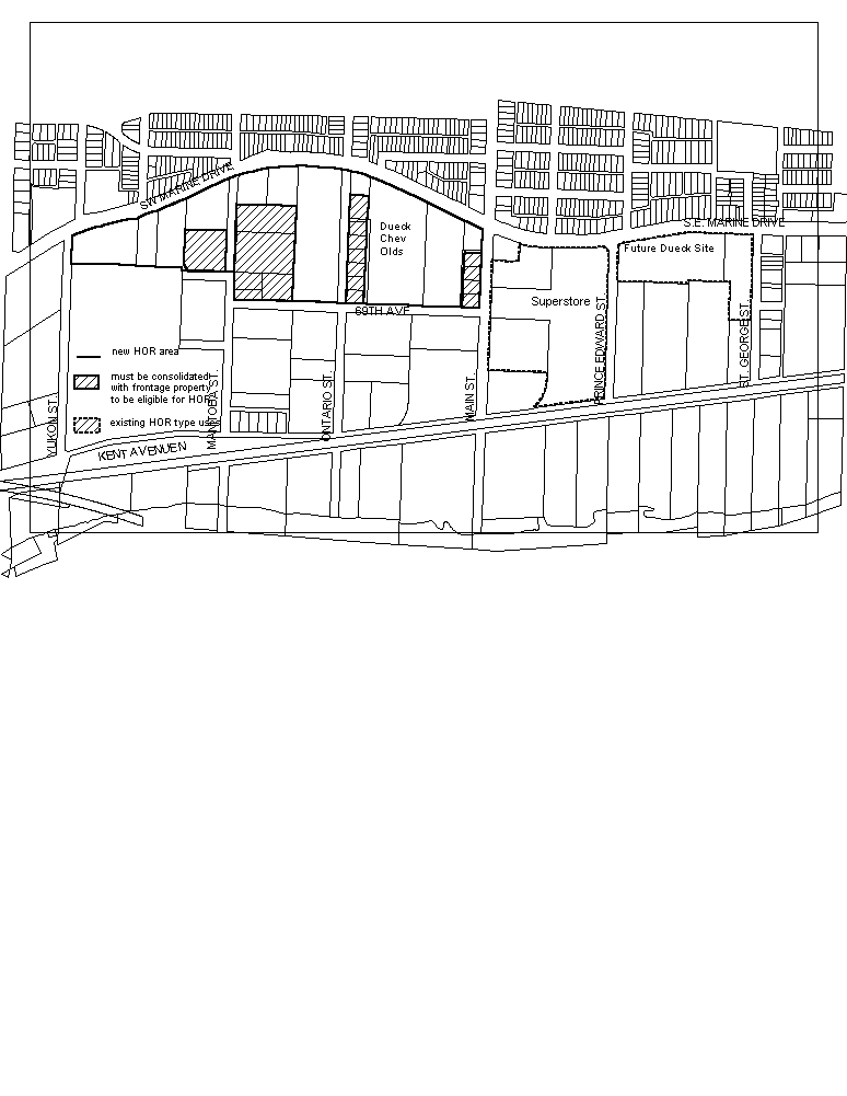
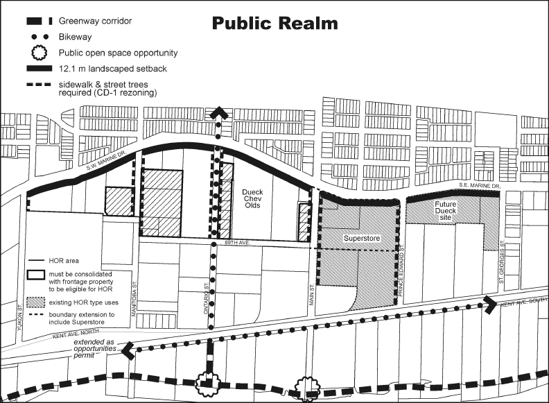
The following rezoning policies and guidelines apply to a portion of the Marine Drive Industrial Area, between Yukon Street and Main Street, as shown in the map below*. The hatched areas on the map west of Main Street may be developed for HOR if they are consolidated with frontage properties. The shaded areas east of Main Street are already developed as HOR type retail.
The policies and guidelines are to assist applicants in preparing, and staff and Council in assessing site specific rezoning applications for highway oriented retail use.
Council will consider applications for site specific rezoning to CD-1 (Comprehensive Development District), for the purpose of large scale retail uses. HOR will be a permitted use in addition to those currently allowed in the I-2 district schedule. The minimum size of retail store will be 929 m² (10,000 ft2).
It is anticipated that some development applications will include the conversion of existing buildings to retail or mixed HOR/I-2 use. Since existing buildings may not be located at the landscaped setback/build to line, or may exceed the desired maximum building width or depth, there may be a need to retain a flexible approach to the application of relevant guidelines.
* Note: Boundary to be amended if Council approves Consideration Item F(ii).
1 Rezoning Criteria
The following criteria will be applied in assessing rezoning applications to rezone sites to CD-1 (Comprehensive Development) for highway oriented retail uses.
1.1 Retail Uses and Impact on Neighbourhood Centres
The type of uses suited to the HOR area are those not normally found or appropriate in a neighbourhood centre. Neighbourhood centres, usually developed from existing shopping areas, are the `heart' of a neighbourhood. It is here that people find shops, jobs, neighbourhood-based services, public places that are safe and inviting, and a place to meet neighbours and join in community life. Examples of types of retail that would be better accommodated in the HOR area include:
· retail which requires large sites by nature of the product (eg. large display areas needed, bulky items such as furniture retail, home improvement stores);
· retail that generally requires the use of a car;
· retail that serves a wide catchment area; and
· retail that does not sell goods that are or can be conveniently available in neighbourhood centres or other commercial areas.
The proposed use should not undermine the role of nearby neighbourhood centres by drawing customers away from local stores. Food and clothing retail often form the basis of local shopping areas and it is probable that large scale retailers selling these products will find themselves at odds with City policy and may not be successful.
The type of retail use is not limited. However, retail uses including food and clothing will require a retail impact analysis to be paid for by the applicant*. Staff will set the terms of reference and hire an independent consultant. The extent of the trade area to be examined will depend on the proposed use. The study should demonstrate how the proposed development will affect retail competition in the determined trade area. Projects are preferred which are likely to permanently increase the number and variety of competing retail businesses in the area. Applications which reduce competition or which could lead to store closures in the trade area are discouraged.
* to be amended if Council approves Consideration Item A(ii).
1.2 Floor Space Ratio
The FSR for retail uses should not exceed 0.6 with a minimum retail floor area of 929 m² (10,000 sq. ft.) for a single-tenant store. For mixed use buildings an FSR of 3.0 is achievable (ie. retail space up to 0.6 FSR and additional uses permitted in the I-2 district schedule up to 2.4 FSR).
1.3 Height
The maximum height should be 12.2 m (40 ft.), relaxable to 18.3 m (60 ft.) for mixed use developments (eg. retail at grade and I-2 permitted uses above). Massing criteria as presented in the design guidelines should be respected by new development.
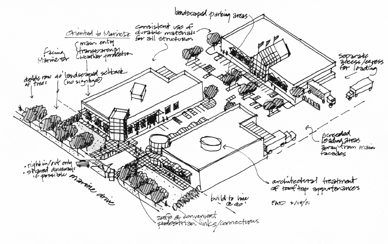
1.4 Marine Drive Frontage
All HOR sites must have frontage to Marine Drive. Panhandle sites are generally not supported for rezoning.
1.5 Setbacks and Side Yards
A 12.1 m (40 ft.) landscape setback currently exists for I-2 zoned properties fronting on Marine Drive between Cambie and Crompton Streets. The same setback requirement should be maintained for the HOR area, net of any property requirements for road improvements. The setback should be free of parking and manoeuvring areas, signs and product display. Vehicular and pedestrian access will be permitted on the setback.
In order to ensure pedestrian interest and orientation to Marine Drive, buildings should be located at the landscaped setback line for a minimum of 50 percent of the Marine Drive dimension of the lot.
An exterior side yard setback of 1.0 m (3 ft) should be observed for all sites adjacent to a street.
1.6 Impact on 69th Avenue
HOR activities and uses extending to 69th Avenue should compliment the adjacent industrial uses (e.g. loading, storage, warehousing).
1.7 Traffic, Parking and Access
Marine Drive is an important corridor for transportation, goods movement and other traffic. To protect it and improve safety, a traffic and parking analysis will be required (paid for by the applicant), indicating likely traffic impacts. The study should examine the potential impacts on the adjacent street system and identify traffic management measures to be taken.
Access directly onto Marine Drive should be minimized where possible through the use of shared accesses and enhanced internal circulation as well as access from side streets. The City may require the applicant to provide safety improvements for vehicular traffic such as left turn bays or traffic signals as well as enhanced pedestrian and bicycle circulation and the creation of safe links between residential areas to the north and recreational paths along the water.
Parking requirements should be consistent with the Parking By-law requirement for Grocery Stores. Where the retail use is for furniture, or similar type of retail, the City Engineer may determine a lower parking standard will apply.
1.8 Landscape
The treatment of the landscape setback should form part of the landscape plan, which must accompany the rezoning application.
1.9 Design Guidelines
Developments should improve and enhance the quality of the public realm through high quality architectural building expression, careful site planning, public and private landscaping and appropriate vehicular and pedestrian circulation.
The rezoning application should demonstrate that, based on the design guidelines, the proposed rezoning enhances the physical environment, by furthering the intent of the following design guidelines.
2 Site Considerations
2.1 Topography: Adjustments to Grade
Any significant alterations of existing grade should support convenient pedestrian access to property, reflect the natural slope of the land and help visually integrate building massing into the landscape.
3 Vehicular Access, Off-Street Parking, and Loading Areas
(refer to Parking By-law)
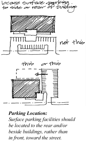
3.1 Parking Facilities
(a) No parking or manoeuvring will be permitted in the landscaped setback.
(b) Surface parking facilities should be located to the rear or beside buildings.
3.2 Shared Driveways to Reduce Curb Cuts and Impervious Surfaces
Shared driveways to abutting properties should be provided where possible to maximize safety and orientation, minimize impervious surfaces, and increase the landscaped buffer bordering the properties.
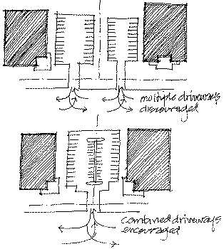
Vehicular Access & Parking: Shared driveways and parking facilities can reduce impervious surfaces and simplify turning movements from busy streets.
3.3 Landscaping and Screening of Parking and Loading Facilities
(a) A layered landscape treatment should be provided to screen parking and loading areas while providing strategic visual access to signs, entries and access areas.
(b) Safety and security are important factors in the layout, size and characteristics of plant material and earth-berming that affect visual access throughout the site.
(c) Security fences should be limited to green covered chain link fence that is accompanied by appropriate hedging or other plant material that minimizes its visual impact and takes into account Crime Prevention Through Environmental Design (CPTED) principles.
3.4 Loading Areas
(a) Loading areas should not be visible from Marine Drive.
(b) Loading area access should be from side streets, streets abutting the south end of deeper properties, or lanes wherever possible.
4 Public Realm and Streetscape
4.1 General Provisions
(a) Continuous sidewalks should be provided for the site's full street frontages to encourage pedestrian use.
(b) Street lighting should be provided to Engineering standards.
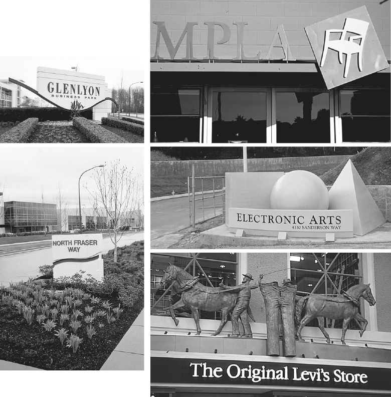
(c) Opportunities for public art and historical references are encouraged.
(d) Crime Prevention Through Environmental Design (CPTED) principles should be followed.
(e) Landscape design should provide for views into buildings, as well as special features.
(f) Opportunities for pedestrian interest along the site's frontage should be provided.
(g) Landscape design should provide opportunities to sit, view or take part in walking or active recreation.
(h) Appropriate secondary direct and indirect landscape lighting and building lighting should be provided and not spill over onto adjacent sites or generate glare.
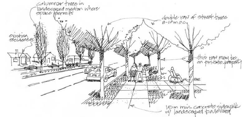
4.2 Public Realm and Streetscape on Marine Drive
(a) A landscaped boulevard and sidewalk with a double row of street trees is considered suitable for this major thoroughfare.
(b) One row of street trees should be located in the boulevard, and the second row located behind the sidewalk.
(c) Preferred spacing of trees is 8-10 m (26 - 33 ft), taking into consideration building entries and driveways.
(d) Space limitations may result in the second row of trees to be located within the landscaped setback.
(e) Landscape treatment of corner sites should contribute to the pedestrian amenity of these intersections by providing feature landscaping, seating areas and, where possible, public art.
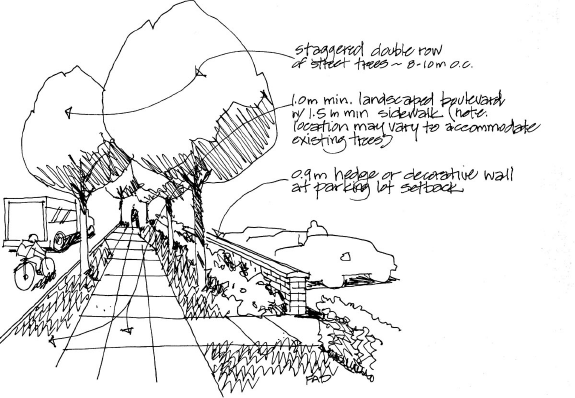
4.3 Public Realm and Streetscape on North-South Streets
A variety of conditions exist on the north-south streets in the HOR area (Yukon, Manitoba, Ontario, Main and Prince Edward). Some have sidewalks, others do not. While some properties have existing street trees, they are not necessarily located the same distance from the curb. Accordingly, the guidelines should be applied in a fashion that encourages both continuity of treatment and retention of existing street trees. The introduction of a continuous sidewalk should also accommodate existing street tree locations, with adequate pervious surface area at the base of trees.
(a) A minimum 1.0 m (3 ft) landscaped boulevard is encouraged, with spacing of street trees from 8-10 m (26 - 33 ft) apart.
(b) A standard 1.5 m (5 ft) concrete sidewalk is required.
(c) A second row of street trees is encouraged, in a staggered pattern with the boulevard trees, and with similar spacing.
(d) Low feature plant material should be located in the required landscape setback.
(e) Surface parking lots should be set back a minimum of 1.2 m (4 ft) from the property line and screened with a either a hedge or low wall at a minimum height of 1.0 m (3 ft).
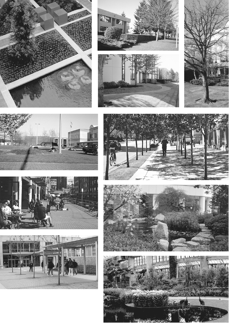 Public Realm and Streetscape
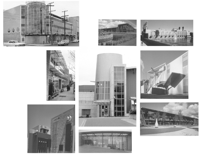
5 Architectural Characteristics
5.1 Height
(a) For Highway Oriented Retail stand-alone developments, a height of 12.2 m (40 ft.) is recommended.
(b) For mixed use projects, the Director of Planning may consider height up to 18.3 m (60 ft.) where view impact studies demonstrate reduced impact to nearby residential properties and where increased height also assists in providing usable open space at grade.
(c) Notwithstanding section 5.1(a), a building's height should not exceed 9.2 m (30 ft.) to a depth of 9.2 m (30 ft.) from the required landscaped setback for sites bordering Marine Drive.
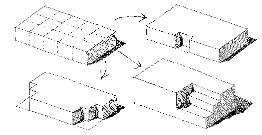
5.2 Building Width and Depth
(a) Neither the width nor depth of an individual building should exceed 61.0 m (200 ft.).
(b) Additional width or depth may be considered where the proposal demonstrates visual interest.
(c) Where the need for longer, wider buildings can be demonstrated, consideration should be given to facade articulations, and connections by transparent bridges and walkways on the upper floors.
5.3 Massing and Form
(a) Larger sites and larger buildings can accommodate a variety of building forms and massing options.
(b) Generic "big box" building designs that exhibit little facade interest and transparency to the street should be avoided.
5.4 Main Entries to Street
(a) Multiple building entries are encouraged, in order to provide convenient access from Marine Drive, flanking streets and parking facilities. At least one main building entry is required to be oriented to and directly accessible from Marine Drive.
(b) Pedestrian interest and comfort at entries should be provided through specifically designed seating, signage, lighting and features that signal the building's use.
(c) Separate entrances for non-retail uses are encouraged.
5.5 Building Articulation
(a) Building articulation can be achieved utilizing vertical or horizontal offsets, glazing, canopy and shading systems, as well as exposed structural components.
(b) Highly visible circulation and building systems are encouraged.
(c) Vertical service elements, such as stair and elevator shafts, that are located to the perimeter of the building, may be used to assist in articulation, as well as express their function.
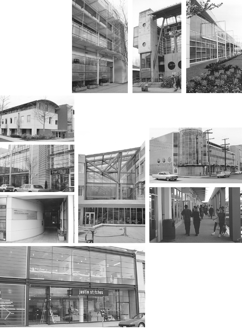 Architectural Characteristics
5.6 Weather Protection
(a) Main building entries should provide generous weather protection that is designed to be an integral feature of the building's architectural character.
(b) All commercial frontages along Marine Drive should provide full weather protection.
(c) Canopy and/or awning systems detailing should consider integrated signage, lighting and display systems.
(d) Canopy and awning systems depth should be maximized to provide greater weather protection, as well as reduce the scale impact of larger buildings.
(e) Weather protection elements on overhangs may be considered in required yards and landscaped setbacks.
(f) Storm water runoff from building roofs and parking lots should be managed on site as much as possible to reduce impacts on area infrastructure and address environmental factors.
5.7 Transparency
Views into building activities should be provided, especially at grade levels from perimeter streets; accordingly, use of non-transparent, mirrored or highly reflective glass is discouraged.
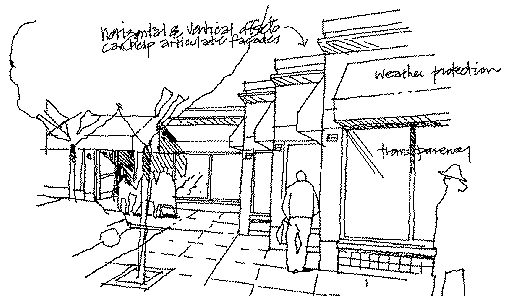
Transparency and Fenestration:
High clearance warehouse-type spaces should have windows at the upper storey of the facade.
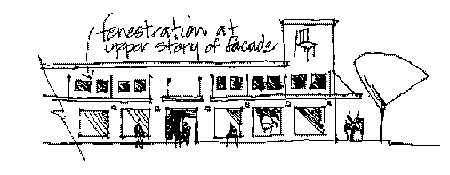
Comfort and Interest
at grade level.
5.8 Exterior Materials
(a) Exterior building design should reflect the industrial character of the precinct by utilizing appropriate, durable materials.
(b) Exterior materials that are encouraged include:
· contemporary metal cladding systems;
· heavy timber structural elements;
· glass and steel;
· brick; and
· architectural concrete.
(c) Roofs visible from residences on the north side of Marine Drive and adjacent areas should be architecturally treated and/or landscaped. Rooftop mechanical equipment should be screened and architecturally integrated into the overall building design.
6 Open Space, City Greenway and Bikeway
(a) Direct public connections through sites should be provided where appropriate taking into account CPTED
(b) Neighbourhood Greenways connections should be incorporated where appropriate
(c) The Ontario Street bike route designation should be reflected in the streetscape design, where applicable.
7 Outdoor Storage and Display Areas
(a) Outdoor storage areas should be limited to the rear yard areas, screened from streets and main entrances.
(b) Screening should include fencing, plantings and earth berms that filter undesirable views.
8 Signage and Lighting
Signage and lighting size, placement and character should take into consideration both the overlook potential from residential areas north of Marine Drive as well as the intended parkway character of Marine Drive itself. Marine Drive HOR CD-1s will be assigned the C-1 district sign provisions. In addtion:
(a) No signs will be permitted in the Marine Drive landscaped setback area.
(b) Billboard signs and mobile signs should not be located on a site.
(c) Internally, illuminated backlit sign boxes are discouraged.
(d) Corporate and multi-tenant signs should be subordinate to and architecturally integrated with the development.
(e) Street and entry path lighting should be integrated into site design.
(f) Building and landscape lighting should be included with landscape features.
(g) Pole mounted lighting should include cut-off shields to minimize impact on nearby residential properties.
 Signage
9 Environmental Considerations
9.1 Trees and Vegetation: Retention, Relocation and Replacement
(a) Existing trees and vegetation should be retained where possible and incorporated into site planning.
(b) Groups of trees should be retained to protect against potential isolated tree hazard situations and preserve the associated understorey vegetation for minimum disturbance of existing conditions.
(c) If tree retention is not possible, as a second alternative, the trees should be relocated to other parts of the site.
(d) As a third alternative, tree replacement with the appropriate tree species and location in keeping with the site's development, should be considered.
(e) A variety of native trees and vegetation should be provided to minimize maintenance, water use and integrate the planting design into the traditional landscape character as much as possible.
(f) Existing planting patterns and connections to adjoining properties should be extended and reinforced where possible.
9.2 Water: Surface and Groundwater Protection
(a) Permeable surfaces should be maximized to reduce stormwater runoff and recharge groundwater in the following priority order: first grass, then gravel on sand and, third, paving stone on sand.
(b) Consider providing on-site stormwater storage by incorporating ponds or similar recreational/amenity features that have dual functions.
(c) Oil interceptors and/or other treatment works should be installed to treat (filter and reduce) surface runoff from parking lots.
(d) Grey water should be recycled on site, if possible, for irrigation purposes to reduce water use, waste water and runoff.
9.3 Soils: Retention, Cleansing and Replacement
(a) Topsoil disturbed during construction should be retained, where possible, to provide a rich basis for site planting and landscape development.
(b) Soil quality should be improved where necessary by remediation on site or relocate soil where appropriate.
(c) Contaminated soils should be reconditioned or replaced with quality soils to enhance plant growth and water quality.
(d) Sites and development proposals shall meet Provincial requirements where existing soils are polluted or otherwise toxic.
9.4 Air Quality and Transportation: Proximity and Land Use
(a) Walking and bicycling should be encouraged by linking development to adjacent bikeways, greenways and other pathways.
(b) Convenient, safe and accessible pedestrian and bicycle connections should be provided to major bus routes.
9.5 Energy: Conservation and Efficiency
(a) Buildings should be oriented to maximize solar orientation, taking into consideration building placement and planting design.
(b) Building materials, systems and construction methods should be used to conserve energy and reduce long-term operating costs.
9.6 Solid Waste: Reuse and Recycle
A comprehensive waste management plan is encouraged among land owners that can provide recycling and reuse in close proximity by different industrial or retail uses.
10 Public Benefits and Infrastructure
(a) Service and amenity contributions such as road, traffic management, roadway upgrading, utility upgrading, and the provision of open space will be negotiated on a site-by-site basis.
(b) The City-wide DCL Rate for commercial and retail uses will apply to new development and additions to existing development in the Marine Drive HOR area. The money will be used for infrastructure and public amenities throughout the city once Council approves spending criteria.
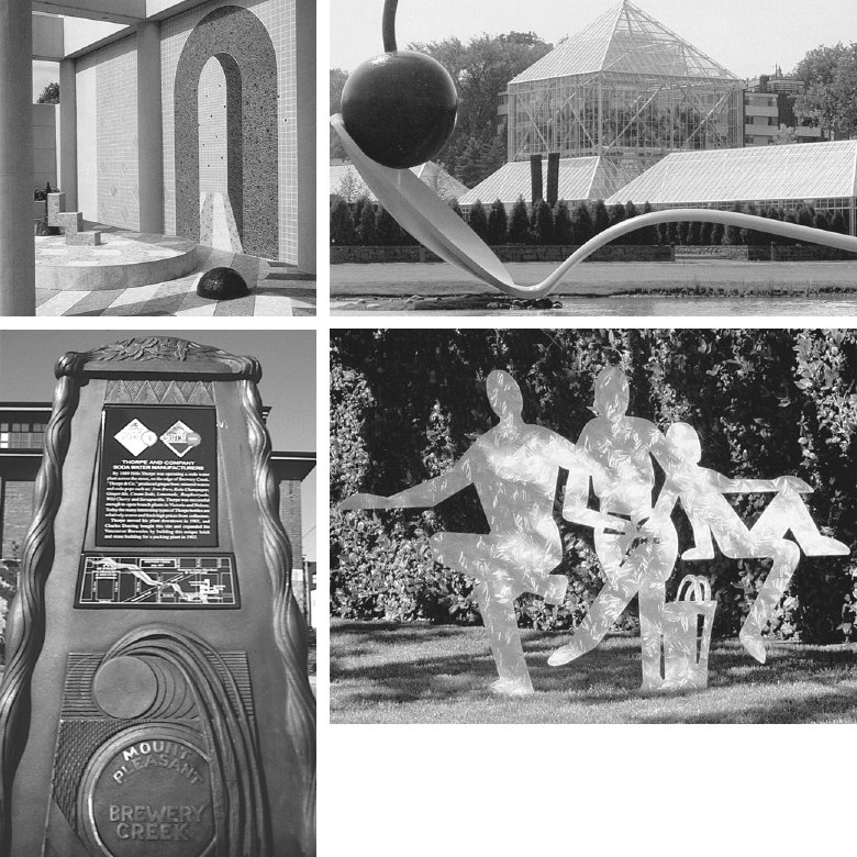
Public Art