
|
|
Potential Development Concepts
Assumptions
It is assumed that in a development of the lands, the City would plan, rezone, service and subdivide the lands into individual development parcels, which can then be sold or long-term leased to individual developers or builders to construct the buildings. The City may consider joint venturing with individual developers and builders, using the land as equity asset to participate in the construction of buildings, and share in the development profits and risks.
Regarding the Egmont property and the privately owned Sauder property, it is assumed that the City would either purchase or exchange land with the owners, in order that a comprehensive development site can be provided. On the B.C. Transit property, since it is on the eastern edge of the City owned sites, may not be required as part of the redevelopment of the City lands. If and when B.C. Transit wishes to redevelop their land, it can be dealt with separately within an overall development plan encompassing all the sites.
Economic proforma analysis for the purposes of this report are based on current market condition and outlook. Land cost is based on current market value of the land, rather than the actual purchase cost plus carrying costs. In projecting revenues, freehold selling values are used. Other costs are estimates based on known data at the present time, and the estimates are subject to review when a detailed design and detailed technical data are available.
The Consultant believes that the complete build-out of the buildings in a development of Southeast False Creek would take ten years, although six years would be sufficient to complete construction of parks, shoreline, infrastructure, site servicing and marketing of the subdivided sites.
Consultations
Several development concepts were made during the first half of the work period, and a number of experienced and knowledgeable individuals were consulted by telephone and meetings. Following a preliminary analysis of the development concepts, a private workshop was held on September 27th 1996 to discuss the directions taken in creating the development concepts with a group of respected guests in the development industry.
The participants are as follows:
Table 4: Workshop Participants
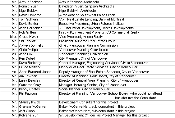
The Consultant appreciates the guest participants’ time contribution and useful comments, which have been considered and incorporated into a development concept named Creekside Landing presented in this report.
Resource
The City seconded, on a half-time basis, Mr. Kolvane Yuh, Senior Property Development Officer, who managed the project, performed economic analysis and prepared this report under the Consultant’s direction. The Consultant’s secretary, Ms. Janet Fung provided in-house secretarial help on the project. Other services were contracted on a sub-consultant basis as follows:
- Architecture and planning by Baker McGarva Hart: Mr. Graham McGarva and Mr. Jeff Olson;
- Preliminary infrastructure design and cost estimate by Hay & Co (Mr. Robert Gardiner: Servicing), N.D. Lea Consultants Ltd. (Mr. Roger St. Louis: Roads and Mr. Brian Wallace: Traffic) and Golder Associates (Mr. Richard Butler: Geotechnical);
- Environmental site cost estimates by MTR Consultants Ltd.: Mr. Ted Ross; and
- Market valuations by Richard Ellis Cumberland: Mr. George Oikawa.
Sustainable Development
Sustainable Development is difficult to define. The issue was discussed with a number of individuals, including City planners, members of the Vancouver Planning Commission, the Special Office for the Environment and in the September 1996 workshop. However, no meaningful definition was agreed.
It would appear that sustainable development should be applied in a macro sense and in a regional context, e.g. farm lands should be retained for food production, open space reserved for wild life and recreation, and urban areas reinforced as cities and towns. Urban sprawl encroaching into farmlands should be viewed as against sustainable development. On the other side, urban intensification should be viewed as supportive of sustainable development.
On a micro level, suitable planning and design, not only involving compact, mixed-use, transit supportive development but also advanced applications in the management of energy, waste and natural ecological systems, including water and landscapes should be looked into, taking into account costs and benefits.
In Creekside Landing, sustainability is already a key principle behind the development concept. While the criteria will be refined in the next planning phase, there is a consensus from the literature and planning practice on the subject that Creekside Landing’s vision embodies the goals for sustainable urban development. This vision is for a mixed use "walking" neighbourhood which has a critical mass and a strong identity in itself, and which is also integrated with the City’s utility and transit infrastructure. Following the principles City Council has established regarding housing mix, and provision of community facilities will further reinforce the social sustainability of this new community.
The City Planning Department is managing a detailed consultant study on relevant applications for environmental sustainability in Southeast False Creek development. The study will give clarity on economic parameters of environmental sustainability. The possibility of an initial cost premium and any savings over the long run will be expected from the study. The appropriate results, when available and their acceptance by the market place will be taken into consideration in the Southeast False Creek development.
Potential Development Concepts
A number of potential development concepts were created and studied. Most of the concepts were found to fall short of the City’s objectives in respect of the Southeast False Creek lands. The following concepts are discussed due to their greater relevancy as follows:
- No development;
- An industrial/office park development concept; and
- A residential development concept called Creekside Landing.
The other concepts are comprised of a mixed residential and industrial development and a variety of residential developments; details are included as Appendix "B".
No Development
This scenario assumes that the status quo will be maintained, and no development will occur. The lands will continue to be rented, perhaps at a longer lease term resulting in higher rental revenues. There will be no compelling reasons to acquire the Egmont property and the privately owned Sauder property.
This scenario normally is available as an alternate option to immediate development to a property owner, over a long or short term. The notion is that if the market uncertainty is considered to be too great for a development to proceed, the real estate can be used as a holding property generating some revenue, until a more favourable market condition in the future.
For the purpose of this report, the no development scenario is considered to be a base-line case against which the other development concepts would be measured. From a land use and social perspective, a no development scenario would provide:
- no needed housing;
- no social housing;
- no parkland;
- no public waterfront walkway;
- no public access to water;
- no public art;
- no daycare;
- no school site;
- no heritage building retention;
- no economic benefits generated from construction activities ; and
- continuing industrial use for existing tenants;
In the case of the City lands, significant soil contamination has to be addressed in the short term, even in a no development situation. Soil remediation will have to be carried out to an industrial standard. Additional remediation will be required if the lands are to be re-subdivided, which will require new roads and services, within which areas, soil contamination has to be cleaned up. Furthermore, it is probable that a public waterfront walkway will be required as a condition of subdivision approval, hence additional soil remediation at the shoreline. For the purpose of this report, it is assumed that there will be no subdivision, if there is no development.
Preliminary economic analysis of the no development scenario was carried out using two methods: Namely an investment analysis basis and a Net Present Value basis.
On an investment basis, the rental revenues would be far short of recovering soil remediation costs and land carrying costs. At the end of ten years, the investment would suffer an equity loss of $12 Million. The loss will get worse, and in six more years, i.e. in 16 years total, the equity in the real estate would be extinguished. A Net Present Value analysis indicated a loss of $18 Million NPV over a ten year period.
Table 5: Economic Proforma of No Development for 16 year time frame
Table 6: Economic Proforma of No Development (NPV)
Industrial/Office Park Development
Since the lands are already zoned industrial, and soil remediation costs for residential development will be significantly higher than industrial park, the idea of developing the lands into a high-tech industrial/office park was studied.
This development concept would provide:
- no needed housing;
- no social housing;
- no public art;
- no daycare;
- no school site;
- a public waterfront walkway which would be required to gain subdivision approval.
- limited parkland/open-space and access to water along the waterfront walkway;
- heritage building retention which may be required to gain subdivision approval;
- general economic benefits created from construction activities ;
- a higher property assessment base for property tax purposes; and
- supply of industrial/office sites for light and high-tech industries close to downtown Vancouver.
To facilitate an industrial/office park development, acquisition of the privately owned Sauder property would likely be required to reconfigure a grid pattern subdivision. However, the Egmont property may not be required, as a design could be made so that the site forms an integral part of the new subdivision.
A preliminary economic analysis was made and the analysis indicates that under current market condition, it is unfeasible to develop this concept. The time frame to develop the concept may take five years. The cash flow from the development would be a loss of over $25 Million at the end of project completion. In Net Present Value terms, it would be a substantial loss of nearly $30 Million, based on a 7% return.
This part of the report contains an original illustration of an industrial/office park development included as Figure 5., a Gantt chart in Figure 6
Table 7: Preliminary Economic Proforma
Creekside Landing
Description of the Creekside Landing Concept
This concept envisions a comprehensive residential neighbourhood for Southeast False Creek. The conceptual development site would include the Egmont property and the privately owned Sauder property, but the B.C. Transit property is excluded for the purpose of this report.
The concept would generate a new residential neighbourhood of approximately 3,750 housing units for 6,500 people, and a village square by the waterfront, containing up to 100,000 square feet of commercial space. The development would provide 3.2 Million square feet of floor area, at a density of 1.60 FSR based on gross site area, or 3.13 FSR based on net site area, exclusive of parks and roads.
The concept would provide needed housing to the central area of the City of Vancouver. The Urban Futures Institute, recently reaffirmed a strong long range population growth for the Lower Mainland, and forecast a need of 500,000 new households for 1.2 Million people over the next 25 years. Housing on the Southeast False Creek lands is an important City objective, and it does not contradict the City’s Industrial Land Strategy, that had determined the Southeast Shore of False Creek area to be "let go".
The residential buildings would be a mix of two storey town-homes, four storeys low-rise, mid-rise and point towers. The buildings arrangement would be peak and valley, to retain views as much as possible and to create an interesting urban layout. The concept incorporates the retention of the unique and interesting view of the Science Centre structure, from many points inside the development and along First Avenue.
Incremental building blocks enable a varied mix of small and large scale developments. As these proceed they will have the flexibility to respond to changing social and market conditions in the course of the project build out.
Sustainability is a key principle behind the development concept. While the criteria will be refined in the next planning phase, there is a consensus from the literature and planning practice on the subject that Creekside Landing’s vision embodies the goals for sustainable urban development. This vision is for a mixed use "walking" neighbourhood which has a critical mass and a strong identity in itself, and which is also integrated with the City’s utility and transit infrastructure. Following the principles City Council has established regarding housing mix, and provision of community facilities will further reinforce the social sustainability of this new community.
Good accessibility, for daily convenience and for special needs, is a fundamental principle. A street car right of way will run through the neighbourhood, with a stop at the village square, from where a ferry could be taken to the downtown peninsula. These modes of public transportation completes the array of accessibility options in Creekside Landing which also redefines the allocation of territory for pedestrians and automobiles - to the advantage of all users.
The emphasis is on mews instead of standard City streets to provide the service circulation through the neighbourhood. The vision is of a pedestrian friendly environment, where walking is the primary mode of surface circulation, and where vehicular traffic is directed to an incremental traffic and parking system. Unnecessary surface vehicular movements are thereby eliminated while, the mews enable necessary service and emergency vehicles to obtain direct access to their destinations. Therefore, while automobiles are well accommodated, their negative impacts on the community are greatly eliminated.
A village square would be provided on the waters edge, and a pond-like setting is envisioned. Surrounding the pond would be clusters of two storeys commercial buildings, one of which would be the existing Domtar Salt heritage building. The building would be moved from its present location on First Avenue to the waterfront, and a second floor would be created inside the existing building. The building can be used as commercial or community centre space. Overall, the village square would serve as a meeting place, a village centre and the soul for the new neighbourhood.
There would be approximately 18.5 Acres of park, open space and waterfront walkway. A large open park would be linked with a number of smaller parks with a constructed creek-like water system criss-crossing over the park area. The creek system would emphasize the public nature of the public realm, and create an interesting walking experience. The layout of the parks system would also be inviting to nearby communities in passing through it, to enjoy the waterfront walkway along False Creek.
Underneath the existing Cambie bridge, boats can be stored and access to water can be provided near the bridge. At the village square, a gangway and floats can be provided, to permit access to the square by boat and ferry from the north shore of False Creek and Granville Island.
Standard public amenities required in major projects i.e., 20% social housing, daycare, a school site, public art and library levy will be provided in the Creekside Landing concept.
Table 8: Major Project Statistics compared with Creekside Landing
Economic Analysis of the Creekside Landing Concept
A preliminary economic proforma was prepared for the Creekside Landing concept, and revenue and cost estimates are based on independent advice of experienced professional appraisal and engineering firms. The development time is estimated to be six to ten years. The analysis indicates that based on current market condition and outlook, a development of the Creekside Landing concept would produce a positive cash flow of about $12 to $15 Million (all costs including land have been returned) upon completion of the development, compared with an equity loss of $12 Million (real estate value minus investment loss) in a no development scenario for the same time frame.
The projected cash flow over a ten-year period would show a 4.5% IRR, indicating that the development should be feasible at a modest return. However, it should be noted that no profit is factored into the proforma, and the positive cash flow is the only resource to offset development uncertainties.
While private developers and lenders will require a contingency significantly higher than the indicated return, it may be appropriate for the City to consider a modest rate as reasonable, given that the City would realize its planning and development objectives for the lands and enlarging the property tax base. However, given that the return is already modest, there would not be room for any cost-inefficient requirements, without subsidies or a trade-off against econmic viability.
Generally speaking, in order for the Creekside Landing concept to be economically viable, approximately 530 useable floorplates of 6,000 sq.ft. on 44 building parcels, plus the village commercial space will be required. Using an average site coverage of 6,000 sq.ft. per parcel, the necessary floor space could be accommodated in an even plateau of 12 storey towers. Such a rigid uniformity is not consistent with Vancouver’s tradition of urban form and would not readily suit the needs and expectations of the varied socio-economic groups who are envisaged to be making this a socially and economically sustainable community. The plateau concept would have a diminished appeal to the private market, resulting in significant lower selling values.
The type of varied housing form such as in the proposed concept therefore reflects the accomplishment of economic targets in a form of building and open space that caters to all of the community’s members.
Social housing would be provided by Creekside Landing in the form of building sites or air-parcel, upon which social housing funded by BCHMC or others will be built. The report contains an original gnatt chart (Figure 7: Gnatt Chart: Creekside Landing Concept) at this point. A copy of the original Gnatt Chart is available upon request from the City Clerk's Office. Table 9: Economic Proforma for Creekside Landing
Summary of the three previously discussed scenarios
For comparison purpose, the cashflows, investment gain/loss, NPVs and IRRs of the three scenarios dissussed are summarized as follows:
Table 10: Comparison of the returns of three development scenarios
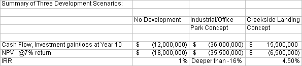
As Table 10 indicates, the Creekside Landing concept would produce relatively a better economic return than no development and an industrial/office park development.
![[City Homepage]](/graphics/footnava.gif)
|
![[Get In Touch]](/graphics/footnavb.gif)
|

|

|

|
Last modified: April 8, 1997
(c) 1997 City of Vancouver