
|
|
City Objectives Pertaining to the Lands
The City objectives as revealed by City bylaws, planning policies and Council resolutions relevant to the development of Southeast Shore of False Creek are as follows:
Land use
On July 26, 1990, City Council identified the Southeast Shore of False Creek as an area that should be released from industrial use and directed staff to report back on a work program to prepare new zoning.
On December 3, 1991, as a part of the Central Area Plan, City Council resolved that:
- Housing should be the predominant land use when planning the Southeast Shore of False Creek; and
- The provision of housing for families with children was identified as a priority for Southeast False Creek.
Council also resolved that the location of the City’s Cambie Works Yard be reaffirmed until at least 2003. However, this time table was changed as later on, on September 28, 1993, Council approved the purchase of the former Burlington Northern Railways lands at Malkin Avenue, partly for the purpose of relocating the existing City Cambie Works Yard. The purchase was completed and City Engineering have been working on the relocation which would likely be carried out in the near future.
Recently on October 22, 1996, Council considered a proposal to rezone the Southeast False Creek area, amongst other areas from the existing M-1 or M-2 zoning to I-2 which is also an industrial zoning. However, Council resolved to not rezone the Southeast False Creek area, in response to representations in public hearing that the area should be left for the time being until a proper rezoning is done on the City lands.
Shoreline, public waterfront walkway, and access to water
It has been a long standing Council policy to acquire City ownership of the shoreline for public access. In 1972-74 the City endorsed a waterfront pedestrian/bicycle system around False Creek. Later on August 30, 1988, Council approved The False Creek Policy Broadsheets which contains a requirement for a continuous public waterfront walkway, designed to separate pedestrians and cyclists.
Blueways
The City’s Water Opportunities Advisory Group, commonly called the Blueways Team, has started public consultation to look at uses of water bodies around Vancouver. As the Blueways Team’s work develops, any proposal to use the False Creek water body at the east end of the Creek, may be relevant to the development of the lands on the Southeast Shore of False Creek.
Provision of park, social housing, daycare, school site, public art and library levy.
The City has a standard requirement for public amenities in the case of a major development, such as the Southeast Shore of False Creek lands. Current park requirement is 2.75 Acres of park per 1,000 population generated from the development. Social housing standard is 20% of housing units created in the development. Daycare facility requirement is based on an established formula. The established library contribution requirement, based on the 1991 rate, is $41 per person on the development.
The City’s Public Art Program calls for 95 Cents per sq.ft. on market floor area; social housing is exempt. On November 17, 1993, City Council approved the Vancouver Arts Initiative that included a recommendation that staff review and report back on the availability and feasibility of developing a City owned site on the south shore of False Creek, as an Arts Resource Centre.
School site and community centre space can be required if the School Board and the Park Board so deem appropriate.
In some major projects, the City has negotiated requirements for things like police boat moorage, salt water pump station etc. but these are special requirement outside of the standard requirements.
False Creek Policy Broadsheets
The False Creek Policy Broadsheets were approved by City Council on August 30, 1988. The document sets out for planning purposes, issues and policies such as shoreline, waterfront walkway, land use, density, parks and public open space, urban design, soil conditions, etc.
Retention of a heritage listed building
The Domtar Salt Building at 85 First Avenue situated on the City lands is listed in the "B" evaluation category of the Vancouver Heritage Register. City heritage policies approved by Council encourage the retention and re-use of listed heritage buildings by offering owners incentives to do so.
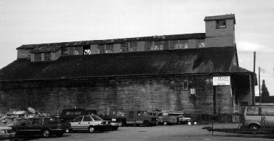
Figure 3: Picture of Heritage Building
Retention of view along First Avenue to Science Centre
The False Creek Policy Broadsheets approved by City Council on August 30, 1988 contains a policy to preserve views of mountain and landmarks, as seen from residences, public spaces, bridges and streets when planning the False Creek basin. The Science Centre structure is commonly considered a notable landmark; given its geometry with First Avenue, the retention of view along First Avenue to Science Centre is given in the Terms of Reference as an objective.
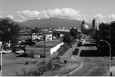
Figure 4: View from 1st Ave to Science Centre
Street car
On February 22, 1995, City Council approved a report on False Creek Streetcar Line and resolved that, as part of the planning process of areas that may be impacted by a potential streetcar line, consideration of preserving a transportation corridor for such use will be taken and the feasibility, costs and alignment options be reported back to Council.
On April 3, 1996, the City announced that it has completed purchase of a 5.4 Acre portion of the old Canadian Pacific False Creek rail site to provide a 1.5 km rail corridor from just west of the Granville Bridge to just west of the Cambie Bridge. This is intended to form the basis for an eventual first phase, of a line that would begin at Science World and the Main Street SkyTrain station, and continue through South False Creek past Granville Island. Furthermore, the City announced the negotiation for a lease of an historic interurban rail car, initially as a visitors’ centre for the street car project, but would be pressed into service once line improvements are made.
Sustainable Development
City Council adopted the Clouds of Change report on October 16, 1990 and the report called for planning initiatives that:
- Bring housing and employment closer together;
- Increase housing adjacent to Vancouver’s Central Area; and
- With respect to the Southeast Shore of False Creek, incorporate principles of energy efficient community design in the area plan.
Furthermore, on December 6, 1994, as part of the Clouds of Change Status Report, Council resolved that the Special Office for the Environment explore with the Real Estate Division, the potential for utilizing the City lands at the Southeast False Creek as a model for sustainable development.
To achieve an economically viable development
The City lands at the Southeast Shore of False Creek are owned by the City’s Property Endowment Fund. An important PEF objective is to produce a reasonable return on the City’s investment in properties, consistent with the City’s planning and development objectives.
![[City Homepage]](/graphics/footnava.gif)
|
![[Get In Touch]](/graphics/footnavb.gif)
|

|

|

|
Last modified: April 8, 1997
(c) 1997 City of Vancouver