

|
|
ADMINISTRATIVE REPORT
Date: June 10, 1999
Author/Local: B. Riera/7683
RTS No. 00333
CC File No. 5560
Council: June 22, 1999
TO:
Vancouver City Council
FROM:
General Manager of Engineering Services and Director of Central Area Planning
SUBJECT:
Downtown Transportation Plan
RECOMMENDATION
A. THAT the planning process for the Downtown Transportation Plan begin in the fall of 1999 on the basis of the work program detailed in Appendix A of this report.
B. THAT $135,000 be allocated in 1999 from Contingency Reserve, and $20,000 from the Parking Site Reserve, $463,000 in 2000 Operating Budget, and $116,000 in 2001 Operating Budget, for a total of $734,000, to cover the costs of the program and extra staff, as outlined in Appendix A.
C. THAT a Steering Committee be established to oversee the preparation of the Plan, to include 3 Councillors, the General Manager of Engineering Services, and the Director of Central Area Planning.
CONSIDERATION
As an alternative to the above, the following is put forward for CONSIDERATION:
D. THAT the planning process for the Downtown Transportation Plan be deferred, for reconsideration in early 2001.
GENERAL MANAGERS’ COMMENTS
The General Managers of Engineering and Community Services RECOMMENDS A, B and C. If Council is not of a mind to proceed now, D is put forward as an alternative.
COUNCIL POLICY
The Central Area Plan, adopted by Council in December 1991, stated that: “A transportation policy report will address a number of transportation issues specific to the Central Area. These include: improving mode split to encourage more commuters to take transit; improving ‘in-town’ transit and circulation; providing for personal trips such as shopping, tourist and cultural-entertainment; ensuring that parking requirements help achieve other objectives such as mode split; determining measures needed for through-traffic; and improving pedestrian and bicycle networks. (Section 5, page 33)
The Transportation Plan, adopted by Council in May 1997 contained twelve policies and fourteen initiatives for the Downtown. These are listed in Appendix B. Initiative (1) reads as follows: “Prepare a transportation and circulation review of the Downtown transit system to improve service and choice, improve regional connections and airport links, evaluate alternative transit vehicles (such as minibuses), establish priorities for “Great Streets”, improve route and destination signage, create pedestrian priority areas, and implement bike lanes and street improvements.” (Section 3.7, page 51)
SUMMARY
Within the next twenty years, the Downtown peninsula is expected to increase to a population of more than 90,000 residents and 185,000 workers. This together with growth since the 1980s, presents new and significant transportation demands on the Downtown transportation system. The Downtown Transportation Plan is urgently needed to address existing and emerging transportation issues in the Downtown.
This report outlines a work program to prepare a Downtown Transportation Plan over a period of 19 months. The program includes a review of the road and transit networks in relation to land use and City planning and transportation goals. It is intended to propose solutions to anticipated transportation problems in the Downtown as transportation pressures increase over the next 20 years.Existing staff resources will not be sufficient to cover the program. Additional planners and transportation engineers will be required as temporary staff or to backfill positions of staff preparing the Plan. Two alternative timings are proposed. The recommended timing would
have the work on the Plan to begin in the fall of 1999. An alternative would defer the Plan until early 2001.
PURPOSE
The purpose of this report is to describe a work program and public consultation program for the preparation of the Downtown Transportation Plan.
1. BACKGROUND
1.1 The Central Area Plan
The Central Area Plan, adopted by Council in 1991, establishes the overall land use framework for the Central Business District (CBD), and the Central Area (which includes the Downtown peninsula and Central Broadway). Of particular importance for transportation, the Central Area Plan provides for a consolidation of office space within the core Central Business District of the Downtown. The land use policies of the Plan are designed to have positive transportation benefits. The Plan encourages more housing close to jobs, and the use of transit. It also reduced the overall Central Area office zoned capacity, but emphasised the CBD’s role as an ‘AAA’ office centre.
A principal initiative of the Plan was to bring office supply and the ability of the transportation system to service that office supply, closer together. The concept is to provide only enough inner city offices in the future for as many workers as can be accommodated without seriously overloading our transportation system, such that it would be harmful to the city’s livability. The Central Area Plan recognised that flexibility should be built into any estimates of office and transportation capacity because of the many variables that influence these projections, the negative impacts that could happen by a rush to beat the ‘cap’, and the intent to undertake more analysis in future work.
Other main goals include: enhancing the economic vitality; preserving activity, environment and character; and enhancing pedestrian movement and comfort. All of these need to be taken into account when enhancing accessibility within the Downtown.
1.2 New neighbourhoods
Around the CBD, areas previously used mainly for industrial and warehousing purposes are in the process of redeveloping into residential neighbourhoods. Areas such as Downtown South, False Creek North, Granville Slopes, Coal Harbour and Triangle West, will see the growth in resident population of the Downtown peninsula increase from about 55,000 people
in 1996, to more than 90,000 people by the year 2021. Employment is expected to increase from about 138,000 workers in 1996, to about 180,000 workers in 2021. This redevelopment represents a profound change in the urban structure of these areas and the demand for new services and transportation. The newly emerging neighbourhoods present new requirements for the city streets which serve them. These streets will provide the network for local transportation. More pedestrians, bikes and transit, and local parking, will place new demands on some streets which had previously acted primarily as part of the wider Downtown road network.
1.3 The Vancouver Transportation Plan
The Vancouver Transportation Plan, adopted by Council in May 1997, followed on directly from CityPlan and the regional transportation plan, Transport 2021. The Vancouver Transportation Plan uses the regional plan as its basic framework, adopting the broad targets of access to the city and the Downtown. The Plan targets for access to the Downtown, and the general policies on access within the Downtown, provide the starting point for this Downtown Transportation Plan. The policies and intended initiatives are contained in section 3.7 of the Vancouver Transportation Plan. These are reproduced in Appendix B to this report.
Over the next twenty or so years, morning peak-period trips to and within the Downtown peninsula are expected to increase from about 95,000 trips to about 120,000 trips. The Vancouver Transportation Plan provides for this increase of about 25,000 trips to be accommodated without increasing the number of cars entering the Downtown. The bulk of this increase, about 20,000 trips, will be accommodated on improved transit, resulting in a total of more than 50,000 transit trips each morning (44% of morning peak trips). In addition, the expectation is for slightly fewer car trips each morning. However, with more people in each car, the number of people using cars (as driver or passenger) will remain about the same. More people will walk to work and bike to work, but the majority of these are likely to be residents of the Downtown.
To achieve this switch from the car there will need to be significant improvements to the city and regional transit systems. It will also require some restrictions on the car, primarily in the form of overall limits to commuter parking. There will also be less road space available to cars as transit occupies more space. As transit demands increase, bus-only lanes or streetcars may require segregated rights-of-way to allow for the smooth flowing of the transit system.
Outside the peak hours, the Vancouver Transportation Plan recognises that although transit will be significantly enhanced, many people will still wish to access the Downtown and travel around the Downtown by car. The Plan proposes no new restrictions on parking for short-stay parkers, who are coming predominantly for shopping or other services during the
day, and for entertainment purposes during the evenings. No reliable projections for these off-peak trips are available at this time.
Current investment in the regional transit system is lagging behind the expectations and requirements of Transport 2021. The enacting legislation for the Greater Vancouver Transportation Authority (GVTA), requires the GVTA to review the regional transportation plan within the next two years.
1.4 Some other important transportation issues
(a) Lions Gate Bridge and Third Crossing
The Lions Gate Bridge has been the subject of an extensive public consultation program over the last few years. The provincial Ministry of Transportation and Highways finally determined in 1998, that the Lions Gate Bridge would be repaired and that there would be no increase in the number of lanes on the Bridge. This conclusion is consistent with Council’s policy and with the Vancouver Transportation Plan.
While Council’s position has been that there should be no increase in the road capacity into the Downtown, the issue of the best location for road access to the North Shore remains. The Downtown Vancouver Association (DVA) has proposed an additional road crossing, the ‘Third Crossing’. The advantage of this could be that through traffic using the crossing would not need to pass through the Downtown. This proposal has not been studied by the City. While the Third Crossing raises important issues of access for Downtown neighbourhoods, it is not proposed that it be examined within this study. This is because it raises issues outside the Downtown and outside the city which cannot be adequately addressed without a broader analysis.
(b) Granville Transit Mall
The Granville Mall was constructed to provide preferential access to the core of the Downtown to buses and taxis. Although this has worked well for transit and transit riders, there have been criticisms from some Downtown businesses and land owners, that the mall detracts from the vitality of Granville Street. A recent report to Council by Hotson Bakker Architects, and funded by the DVA/DVBIA, proposed reconstructing the transit mall as a conventional street for general traffic. In its consideration of the report, Council proposed that the issue be further studied as part of the Downtown Transportation Plan.
(c) Downtown Streetcar system
Staff have completed a study (undertaken by a consortium led by Baker McGarva Hart), which has recently been reported to Council with recommendations that the first phases of a Downtown streetcar system be pursued. This would provide a ‘perimeter’ system linking Granville Island, Chinatown, Gastown, and Canada Place. Additional links to the Roundhouse, Stanley Park and through Downtown, are also possible. While corridors are available to the Roundhouse, and Stanley Park, Downtown extensions need more study due to the number of options and complexities involved. Also, the exact role of the streetcar among modes for movement Downtown, and the connections between modes, needs further analysis.
The initial operation of the streetcar and the first extension from Science World to Canada Place could begin, once funding and the necessary technical work is completed. However, a comprehensive look at the Downtown transportation system would be needed prior to consideration of any additional extensions through the Downtown.
(d) Rapid Transit
The Broadway corridor is currently being examined in two parts. East of Vancouver Community College is being designed for a SkyTrain connection to Lougheed Mall. West of VCC is part of Phase 2. This is still in the conceptual planning stage. The new SkyTrain does not directly affect the Downtown. However, a connection from the Broadway SkyTrain to Richmond-Downtown rapid transit, is expected to be part of a future phase. This may be linked to Vancouver’s Olympic bid. Previous studies have looked at Arbutus and Cambie corridors for this north-south connection. Potential routes within the Downtown, will be examined within the Transportation Plan, to the extent that this is possible.
(e) Richmond Rapid Bus
The Downtown route for the proposed Richmond Rapid Bus has been determined in a previous study. However, confirmation of the optional routings within the Downtown will be considered within the broader context of the Downtown Transportation Plan.
(f) Pacific Boulevard
Council has instructed staff to undertake a study of the urban design for Pacific Boulevard, including sidewalks, and parking facilities. While these can be accomplished without the Downtown Transportation Plan, the broader transportation and adjacent circulation aspects of the long term future role of Pacific Boulevard will need to be considered within the broader transportation planning program.
(g) Major Roads
Georgia Street, Hastings, Howe, Seymour, Smithe and Nelson streets, and the bridges, have been adopted as ‘Major Roads’ by the Greater Vancouver Transportation Authority. Additional roads within the Downtown may also be suitable for nomination, and hence funding. No decisions can be made on further nominations until the Downtown Transportation Plan is complete and adopted by Council.
2. WORK PROGRAM
To achieve the transportation targets proposed for the Downtown, the most important element is a major expansion of transit services. While this is expected to develop gradually over the next twenty years, the decisions on funding, technology, and even routing will lie primarily with the Greater Vancouver Transportation Authority. For the City of Vancouver, the transportation options revolve mostly around the use of the road network. But in addition, residential land use is increasing in areas of the Downtown which historically were more industrial or mixed use areas. For this reason, the function of many streets needs to be reassessed. Where possible the streets should support and facilitate the creation of viable, livable and identifiable neighbourhoods.
The Central Area Plan goals of economic vitality, activity, character and pedestrian comfort require a balanced transportation system. The core problem to be addressed is, how to accommodate the changing pattern of use of Downtown streets. The network must continue to provide adequate access into, around and through the Downtown. It must satisfy CBD commercial needs, as well as serving the needs of the emerging neighbourhoods. The key to resolving this will be to examine the functioning of the road network and circulation patterns, both for the present and the future.
2.1 Main steps in the work program
The work program proposed is organised into seven steps, as outlined below. Transportation issues and opportunities will be identified early in the process. Then the implications for the road network and circulation patterns will be fully explored and evaluated. Computer models will be used to help forecast future trips in the Downtown, and to suggest how vehicles will circulate through the road network. A parallel assessment of transportation impacts on streets, land use, safety, air quality and noise will help to shape a better understanding of the relationship of transportation to the adjoining neighbourhoods and commercial precincts. The public program will invite and encourage people to become involved from the earliest stage. The public will identify problems and opportunities, set priorities, assess the wider implications to the network and to neighbourhoods of proposed changes, and comment on proposals.
The seven steps of the work program are as follows.
Step 1 - Establish transportation system objectives and requirements
The key concerns and requirements for the transportation network and system will be established, together with the likely implications and impacts for Downtown neighbourhoods. The public program for this step will involve meetings with resident, business and other interest groups, and public meetings, to allow early discussion of the expectations of the public program.Step 2 - Set up of transportation computer models and impact assessment
Setting up the computer model will require preparing a finer grained version of the existing regional model. This will involve, constructing new traffic zones in the model, preparing land use and trip projections for 2021, and re-calibration to ensure good fit with current street traffic volumes. Guidelines for impact assessment and mitigation will also be established at this step.Step 3 - Preliminary network and circulation review
The first stage analysis of the network and circulation patterns, will focus on identifying and testing future traffic volumes and problem areas, and impacts, and identifying major requirements for changing the network and transportation system. The public program will focus on a series of working sessions to review the circulation and transportation issues.Step 4 - Transportation component review
At this step a more detailed review will be prepared of individual components of the transportation system and neighbourhood impacts. This will identify present and especially future transportation requirements for each transportation component.Step 5 - Second stage network and circulation review
The second stage review will address network-wide and transportation system problems and opportunities. Network options will be explored and refined, and impacts will be assessed. A range of system options and opportunities will emerge from this step. Working group sessions will allow the public to review issues and consider alternatives.Step 6 - Plan options and choices
This step will focus on finalising the principal transportation options and proposals. It will also indicate impacts in each case. These options and choices will be described in a newsletter for public review and response. A broad community consultation process on options and proposals will collect reactions and concerns. Opportunities for modifications and improvements will be explored.Step 7 - Draft and Final Plan
This step will depend upon public response and consultation. If there is broad support for a single set of proposals, these will be refined as necessary and the Draft Plan prepared for consultation. The Draft Plan will include a commentary on expected impacts. Following public response to the Plan, it will be revised as necessary and resubmitted to Council for consideration. If there is not clear support for a single set of proposals, the project team will report back to Council for guidance.
These work tasks are described in more detail in Appendix A, together with a project schedule. The major elements expected to be included in the final draft Plan are also outlined in Appendix A.
2.2 Public consultation program
The steps of the work program are reflected in and correspond to, the steps of the public program. Details of the public program are contained in Appendix A to this report. The public program allows the public to be involved from the beginning. A series of working group sessions will allow and encourage interested people to become closely involved in discussing problems and opportunities, and reviewing possible changes to the network and circulation. Major choices emerging for transportation in the Downtown would be widely advertised and offered in the form of a report or newsletter on transportation choices or alternatives.
This preliminary public consultation program has already been discussed with a variety of Downtown groups. A first task of the program will be to discuss the proposals more widely and adjust and refine the program as necessary.
Two optional components to the program, an enhanced outreach program and a random sample survey, have been considered but have not been included in the work program described in Appendix A because of cost.
An enhanced outreach program would help to ensure the program reaches people who would otherwise be under represented. This could include different language groups, socially or economically disadvantaged, and employees of Downtown businesses. The cost of the outreach program is estimated at $36,000.
A random sample survey of Downtown residents and businesses could be included as a check on responses to the program. Mail-out surveys were used for the Transportation Plan and the Community Visions program and provided a valuable check on results. This survey is not included in the proposed work program. In part, this is because of the expecteddifficulty of reaching a representative cross-section of people. The cost of the random survey is estimated at about $30,000, if targeted primarily to Downtown residents and workers.
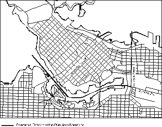
2.3 Boundary of the Plan area
The boundaries of the Downtown for the purposes of preparing the Plan would be approximately west of Main and north of Terminal. However, as a West End traffic plan has already been adopted by Council, only the major arterials in the West End would be reviewed, and these chiefly in terms of their connection with the rest of the Downtown.
3. TIMING, STAFFING AND COSTS3.1 Timing and staffing
The Plan is expected to take approximately 19 months to prepare, including summer and winter breaks for the public program. A schedule for the main tasks and the public program is included in Appendix A.
For the estimated 19 months, staff requirements will average:
- 1.5 engineers;
- 1.5 planners;- 1 planning analyst;
- 1 engineering assistant;
for a total of 5 staff overall for the duration of the project.
3.2 Staff costs
Staffing of other major projects, such as the Broadway-Lougheed Rapid Transit Study, means there is a shortage of staff available. For staff to be assigned to the Plan, ongoing work items would need to be deferred or their positions backfilled by temporary staff.
The cost of planners, engineers and technical assistants needed for the project would total $503,000. Other associated staffing costs for the project, would include, office space ($15,000), and equipment ($30,000). A summary of costs is included in Table 1, with a more detailed breakdown of staff costs included in Appendix A.
3.3 Other Costs
Public program costs
The public program also requires substantial staff time. These staff costs are included in the staff estimates above. Other costs of the public consultation program would total in the order of $69,000 (excluding staff), up to and including the Draft Plan. This includes, advertising, printing of newsletters, Choices papers, draft report and display material, and conducting public meetings. Costs are summarised in Appendix A.Computer transportation modelling
Computer modelling of the transportation network will play a central role in the development of the Downtown Transportation Plan. The work program contains the preparation and running of transportation computer models to estimate trip requirements (by origin and destination), and circulation patterns, for the year 2021. A consultant would be hired to prepare a special Downtown version of the regional EMME 2 model, and a complementary corridor traffic simulation model. Consulting costs, including the cost of the purchase of the simulation model, and staff training, are expected to be in the order of $40,000. Consulting costs would not include most data preparation and running the model. This work would be undertaken by Engineering and Planning staff.Half of this cost, $20,000, could be funded from the Parking Site Reserve, as a significant component of this work would benefit any parking policy or future parking rate evaluation. These computer models would also give the City the future ability to test and examine circulation and traffic issues after the completion of the plan.
Impact assessment studies
Impact assessments would be prepared of the possible changes in transportation and the transportation network. A total of $50,000 would be required to establish a series of baseline measurements and guidelines which would lay the foundations for ongoing impact assessment throughout the preparation of the Plan.
3.4 Summary of costs
The major cost elements for the proposed Downtown Transportation Plan are summarised in Table 1. The total cost of the program, up to the completion and publication of the Draft Plan, is estimated at $734,000, of which $20,000 would be funded from the Parking Site Reserve. If started in September this year, 1999 costs would be approximately $155,000.
3.5 Oversight of plan preparation
During the preparation of the Vancouver Transportation Plan, a steering committee chaired by the Mayor and attended by two other Councillors, the General Manager of Engineering Services and Director of CityPlans, provided general oversight of the project. This arrangement worked well in providing an opportunity for close involvement of Council.
A similar arrangement is proposed for the Downtown Transportation Plan. An appropriate steering committee would include three Councillors, the General Manager of Engineering, and the Director of Central Area Planning.
Table 1: Summary of costs of Downtown Transportation Plan
Cost Item
Full cost
($)
Estimated ADDITIONAL cost of the Plan
($)Other
Optional Costs($)
staff costs
Staff positions backfilled and temporary
$480,000
$480,000
Existing staff positions not backfilled
$63,000
$0
Other staff costs
$23,000
$23,000
Staff cost as far as the Draft Plan
$566,000
$503,000
other costs
Consulting costs for modelling (1)
$40,000
$40,000
Consulting costs for impact assessment
$50,000
Restricted Public Process --
Printing and other costs to Draft Plan include meetings, and documents$69,000
Enhanced Outreach program
--
$36,000
Random survey
--
$30,000
Furniture, equipment and office space
$45,000
Contingency
$27,000
Total other costs
$231,000
$66,000
All Costs up to production of
Draft Plan$734,000
$66,000
Notes: (1) The consulting cost of setting up the transportation computer models is estimated at $40,000. $20,000 of this cost will be funded from the Parking Site Reserve, so the cost to the Downtown Transportation Plan is $20,000.
4. TIMING OPTIONS
There are a number of transportation projects currently underway, primarily the Broadway-Lougheed Rapid Transit study. Each of these is now requiring a substantial amount of time from planners and engineers. Other projects underway or planned for the Downtown in 1999 include:
- Richmond Rapid Bus interim route implementation;
- Downtown Streetcar (Phase I and II parameter routes);
- Downtown bike lanes;
- Downtown greenways;
- Pacific Boulevard urban design;
- implementation of other Transportation Plan elements; and,
- GVTA matters.Preparation of the Downtown Transportation Plan will add to the demands for staffing, and will require the backfilling of positions if the normal work items are to be continued. With this year’s budget constraints, Council may prefer not to commit additional funding at this time. Timing options therefore amount to starting the Plan in 1999, or deferring the Plan for another year or more.
4.1 Option 1: Start program in fall 1999 - Recommended
Option 1 would have the work program described above start in fall 1999. The scheduled completion date of the Plan would be spring of 2001. An early start to the program would allow the Downtown transportation issues to be fully addressed before major developments for SkyTrain and rapid transit from Richmond reach conclusion.
Because not all planning staff positions would be backfilled, starting the Transportation Plan in 1999 would mean that some of the following planning studies will be rescheduled:
- Robson Street guidelines (east end)
- Downtown South amenities, interim uses and heritage
- Library precinct noise and parking impacts.This is felt to be manageable.
4.2 Option 2: Start the program in 2001
Option 2 would be to delay the start of the project for at least 12 to 18 months, for a start in early 2001, or later.
Delay in preparing the Downtown Transportation Plan would mean that the following studies, which are to be addressed in the context of the transportation system and the Plan, might best be also put off:
- Granville Mall Study;
- Water Street Study;
- Downtown Streetcar CBD, Downtown South and West End connections;
- Richmond Rapid Bus final route confirmation.Also, the following work, needing a contemporary transportation context, will continue to be dealt with on the basis of existing parameter and without comprehensive computer modelling:
- Robson Square revitalisation;
- Trade and Convention Centre implementation;
- replanning for the northeast sector of the False Creek North area.Of course, transportation impacts, already affecting new residents in the fast growing Downtown residential neighbourhoods, will be more slowly addressed.
5. CONCLUSION
The Downtown is undergoing significant change. New residential areas are emerging quickly. Streets that previously functioned largely as commuter routes into or through the Downtown, or as access only to commercial, retail or office developments, now also function as local neighbourhood streets serving residents who live in the Downtown.
The Downtown Transportation Plan would identify changes and develop strategies to address them in a balanced manner. It would recognise various competing interests for street space while adhering to the goals for the Central Area. It should also address related issues now on the table, from a comprehensive perspective.
Undertaking the development of the Plan sooner than later is better, noting that the residential community is the fastest growing sector of the Downtown. At the same time, provided related decisions are also put off, delaying the study for a year will not fundamentally compromise any transportation or land use decisions that may have to be made in the next year or two. For example, transportation impacts of major developments would be reviewed in the conventional manner, similar to how they were reviewed for False Creek North, Coal Harbour and the Trade and Convention Centre expansion.
- - - - -
APPENDIX A
DOWNTOWN TRANSPORTATION PLAN --
PRELIMINARY WORK PROGRAMA.1 Purpose of the Downtown Transportation Plan
The Vancouver Transportation Plan (1997), identified “A better transportation balance Downtown” as a key element of the plan. This element, along with the following fundamentals of the plan, will shape the ‘transportation strategy’ for the Downtown Transportation Plan. Fundamentals of the Plan will include:
- addressing the implications of substantially increasing transit to and within the Downtown;
- keeping road capacity to the Downtown at today’s level;
- emphasising walking and biking in the Downtown;
- having roads reflect the new neighbourhoods;
- understanding and mitigating where possible the impacts of transportation on Downtown neighbourhoods.
- addressing the needs of goods movement in the future Downtown when population and employment are greater than at present.A.2 Work program
The work program is organised into seven main steps as described below.
Step 1 - Establish transportation system objectives and requirements
The first step will be to establish the objectives and long-term requirements for the transportation system and Downtown neighbourhoods. It will focus on the present and possible future problems and opportunities, and lead to an outline of the desired performance of the transportation system. This step will be an important opportunity for residents, businesses, workers and transportation interest groups to consider the major transportation system objectives and desired outcomes, and impacts, in relation to the Downtown and the neighbourhoods. Also in this first step, the project team will collect and review basic background information on the performance and requirements for the transportation system.
Step 2 - Set up of transportation computer models and impact assessment
The transportation computer models will help the project team to assess the network performance and estimate the implications of possible network changes for future circulation patterns. The project team will prepare peak period trip projections and estimates of land use changes in the Downtown by 2021. The existing regional transportation model (EMME 2),will be refined for use at a finer level of detail than has so far been available. A second computer model will be overlayed to simulate traffic flows along individual corridors and through important intersections. This combination of models will allow transportation planners and public to test the implications of a range of possible changes to the system, network and circulation. Also, as part of this step, the guidelines for impact assessment will be outlined.
Step 3 - Preliminary network and circulation review
Using the computer transportation models, the project team will work together with the public to gain a better understanding of the system-wide transportation problems and impacts, and examine how expected changes will affect the road network, traffic circulation, pedestrian flows and neighbourhood character.
Step 4 - Transportation component review
Working with transportation interest groups, such as the GVTA, transit users, residents, the trucking industry, the DVA, DVBIA, and other Downtown business groups, the project team will explore specific transportation issues and impacts, and offer proposals for evaluation. The project team will then review ideas for improving specific aspects and performance of each of the components of the transportation system, including, transit, pedestrian and bike routes, goods movement, and parking. An understanding of transportation impacts on neighbourhoods and likely future changes will assist in preparing guidelines for avoiding and mitigating transportation impacts.
Step 5 - Second stage network and circulation review
With a better understanding of transportation issues by type of service, the second stage review will allow the project team to focus on details of the network-wide and system-wide changes. The implications for the future circulation patterns and neighbourhood impacts will be explored. The project team will finalise proposals and options for network and circulation changes.
Step 6 - Plan options and choices
Working with the public in small design sessions, the project team will be able to identify the principal choices and impacts in the transportation system. This step will allow the team to ask the public at large to comment on major transportation options in the Downtown, which might be included in the Draft Downtown Transportation Plan. A Choices paper, similar to the one produced for the Transportation Plan, would explain important choices and options available, and identify likely impacts. The Choices paper would be widely distributed toallow many more people to review the proposals and express opinions on the choices and options.
Step 7 - Draft and Final Plan
The Draft Plan will provide the details of the transportation system and network and circulation proposals. At this step, public review and discussion will allow the project team to report to Council on reactions, and where necessary, recommend changes to the Plan before it is submitted to Council for adoption. The Draft Plan will include a commentary on impacts and mitigation opportunities.
A. 3 Schedule for undertaking the Plan
A preliminary timing for the preparation of the Plan is shown in Table A.1, together with the major stages of the public consultation program. The schedule shown is for a program taking approximately 19 months to the Draft Plan stage. The preparation of the Final Plan would follow public consultation and review.
A.4 Public program elements
The public program proposed follows the steps of the technical work program to allow for discussion throughout the preparation of the Plan. The steps are shown in Table A.3.
Step 1 -- Discuss issues for Transportation System Objectives and Requirements
Step 1 is intended to draw people into the process and encourage their active involvement. A newsletter outlining the program, public meetings, and the expectations for the first step, will be circulated to residents, businesses, employees, shoppers and people using the Downtown. Discussions will address transportation and circulation needs for the future, and the likely impacts and mitigation of transportation changes.
Steps 3 and 4 -- Work on ideas for the network review and transportation components
The network review is organised around a series of workshops which will allow and encourage people to come together to explore the issues and opportunities in the context of circulation and network assessments from the model, and possible impacts. This first round will be mostly focused on problems and ideas for specific parts of the network and transportation system.
Step 5 -- Work on network options and review of packages
In this section, the project team focuses on the main choices, probably in part at least as circulation packages, but also a range of other options. The idea will be to work through in group sessions the reactions and concerns. Out of this should emerge some clear package options and likely impacts. Maybe not. It may be necessary to get some direction from Council because not all options could be taken forward and there is no easy way to reach resolution where there are fundamental differences. The option package should deal with the expression and resolution of these differences, as either individual choices or broader network and system wide options
Step 6 -- Review Draft Plan
The Draft Plan, plus a summary in the form of a newsletter, will be circulated widely, and presented at a series of public meetings. This will allow people to review and discuss the final proposals in the Draft Plan. The results of this consultation will be forwarded, with the Draft Plan to Council for consideration.
A.5 Staffing and other costs
Staffing costs for the program are shown in Table A.2. Staffing is a large element of costs. Additional planners, planning analyst, engineers, and engineering assistant, are required as temporary staff, either to assist on the preparation of the Plan or to backfill positions of staff working on the Plan.
The cost of the public program totals $69,000, over and above staff costs. These costs are itemised in Table A.4 below. Two optional items, an enhanced outreach program and a randomised sample mail-back survey, are listed in the table but are not included in the cost of the public program
The total additional cost to the City of the program on this basis is estimated at $734,000, of which $20,000 would be funded from the Parking Site Reserve. With a start date of September, 1999, the costs for each year would be as follows:
1999: $155,000
2000: $463,000
2001: $116,000A.7 Issues to be addressed in the Plan
Not all issues can be covered in the Downtown Transportation Plan or covered to the same level of detail. The list in Table A.5 indicates the issues to be addressed, and whether these issues are expected to be resolved to a level of detail with firm recommendations, or outlinedfor future resolution. Where specific proposals are marked ‘Recommended’, it should be possible for these to be included in the Draft Plan for Council’s consideration.
Table A.1 -- Preliminary Project Schedule for Downtown Transportation Plan
MAJOR TASKS
Time in months from start date
1
Sep 992
Oct3
Nov4
Dec5
Jan
006
Feb7
Mar8
Apr9
May10
June11
Jul13
Sep14
Oct15
Nov16
Dec17
Jan
0118
Feb19
Mar20
Apr(1) Transport Objectives
xxx
xxx
xxx
xxx
xxx
RtC
Public program (Step 1)
New
Ms
(2) Model Set up
xxx
xxx
xxx
xxx
xxx
(3) 1st network review
xxx
xxx
(4) Transport Components
xxx
xxx
xxx
xxx
RtC
Public program (Steps 3&4)
New
wk
wk
wk
(5) 2nd network review
xxx
xxx
(6) Prepare options and choices
xxx
xxx
xxx
RtC
Impact Assessment
(part of most steps)x
x
x
x
x
x
x
x
x
x
xx
xx
x
x
xx
Public program (Steps 5&6)
wk
New
Ms
(7) Draft Plan
xx
xxx
xxx
Public program (Step 7a)
New
Ms
(7b) Final Plan
xxx
xxx
RtC
(7c) Prepare glossy
Final plan version following adoption by Council
>>>
RtC -- Report to Council; Ms --general public meetings; New -- newsletters etc; wk -- public working sessions
Table A.2: Costs of Downtown Transportation Plan
COST ITEM
Status of project staff
Full costs
(3)Additional cost of the Plan
Optional costs not included
Staff Costs
Planner III (19 months)
backfilled staff
$130,000
$130,000
Planner II (part time over 19 months)
existing staff
$63,000
$0
Planning Analyst (19 months)
temporary staff (2)
$86,000
$86,000
Engineer III (19 months)
backfilled staff (2)
$130,000
$130,000
Engineer II (part time over 19 months)
backfilled staff (2)
$55,000
$55,000
Engineering Assist III (19 months)
temporary staff (2)
$79,000
$79,000
Other staff costs
$23,000
$23,000
TOTAL STAFF COST
$566,000
$503,000
Other Costs
Traffic modelling (4)
$40,000
$40,000
Impact assessment studies
$50,000
$50,000
Public program (not staff (1))
$69,000
$69,000
Enhanced outreach program
$36,000
Random sample survey
$30,000
Furniture and Equipment
$30,000
$30,000
Office space
$15,000
$15,000
Contingency (5% of staff and associated costs)
$30,000
$27,000
TOTAL OTHER COSTS
$234,000
$231,000
$66,000
TOTAL STAFF AND OTHER COSTS
$800,000
$734,000
$66,000
Notes: (1) Public program costs are listed in Table A.4. (2) Temporary staff needed for project or to backfill assigned staff. (3) Full staff costs include costs of all existing and new staff expected to be allocated to the project. (4) $20,000 would be funded from the Parking Site Reserve.
Table A.3 -- Overview of public program for Downtown Transportation Plan
WORK STAGE
Main public program events
Public material
Level of involvement
AWARENESS OF ISSUES
1. Objectives and Requirements
Pubic meetings
Meetings with groupsNewsletter
All levels
WORKING THROUGH THE IDEAS
3. 1st Network review
Working sessions
Newsletter
Session materialSmall working groups
4. Transportation components
RESOLUTION BY WORKING ON OPTIONS AND REVIEWING PROPOSALS
5. 2nd Network review
Working sessions
Public meetings----
Small working groups
6. Plan options and Choices
Public meetings
Options package newsletter
Broad public involvement
7. Draft Plan and Final Plan
Public meetings
Draft Plan report and summary
Revisions for final planBroad public involvement
Table A.4 -- Resources and details of main public program components
Public Program components
Planners and Engineers
Main program
costsOptional survey
Optional outreach
program(2)Preparation time
(1)Delivery time
1. Transportation objectives and requirements
Public meetings
10 days
5 days
$8,000
Meetings with groups
10 days
$13,000
Special events
---
---
---
Newsletter
10 days
na
$8,000
$5,000
3. 1st network Review and 4. Transportation components
Working sessions
5 days
10 days
$5,000
$2,000
Session material
5 days
na
$1,000
$2,000
Newsletter
10 days
na
$8,000
$3,000
5. 2nd network review and 6. Options and 7. Draft Plan
Working sessions
5 days
10 days
$3,000
$2,000
Public meetings
5 days
5 days
$10,000
$2,000
Options package newsletter
displays10 days
5 days
$13,000
$2,000
$4,000
Draft Plan report and summary
displays5 days
5 days
$8,000
$2,000
Public meetings
5 days
5 days
$3,000
$1,000
Random survey (2)
$23,000
Response analysis (2)
$7,000
Impact assessment
10 days
--
TOTAL PUBLIC PROGRAM
80 days
55 days
$69,000
$30,000
$36,000
Note: (1) Preparation time estimates are for presentation of material already prepared. (2) Items not included in budget.
Table A.5 Issues to be addressed in the Downtown Transportation Plan
Transportation Item
Proposed resolution in the Plan
Recommend
Outline
Follow up
1. Overall Transportation Strategy:
a. Elaborate approved strategy, and mode targets
Recommend
2. Network and circulation patterns:
a. Revised arterial streets network
Recommend
b. Confirmation of Major Roads designations
Recommend
c. Future of Granville Mall
Recommend
d. Neighbourhood streets
‘high streets’ and implicationsRecommend
------
Outlinee. Circulation patterns
Recommend
f. Pedestrian areas and priority areas
Recommend
g. Bus lanes, priority measures, transit mall
Recommend
h. Transit interchange areas, initiatives
Recommend
i. Bike lanes
Recommend
3. Transit Improvements:
a. Boarding area improvements, initiatives
Recommend
b. Implications of new bus routes and changes needed
Outline
c. Proposals for service improvements and zone fares
Outline
d. False Creek Streetcar extension opportunities
Follow-up
e. Connections to Airport
Follow-up
f. Confirmation of Rapid Bus routings
Recommend
4. Pedestrian and Bike improvements:
a. Pedestrian environment
Recommend
b. Greenways and green links
Outline
5. Goods Movement:
a. Port access improvements
Follow-up
b. Truck routes
Recommend
c. Truck restrictions, if any
Outline
d. Route and destination signage
Follow-up
e. Highway 99 directions to Second Narrows
Follow-up
6. Streets:
a. Design intentions and standards changes
Follow-up
b. Building line changes
Follow-up
c. ‘Great Streets’ opportunities and implications
Follow-up
d. Traffic noise criteria for neighbourhoods
Follow-up
e. Implement street improvements
Follow-up
7. Cars and Parking:
a. Commuter parking limits and
regulation changesRecommend
------
Follow-upb. Parking supply requirements
Recommend
c. Short-stay supply requirements
Recommend
d. Car co-ops and rental agency zoning issues
Follow-up
e. Residential standards review
Follow-up
f. Employee parking charges
Follow-up
* * * * *

APPENDIX B
VANCOUVER TRANSPORTATION PLAN
SECTION 3.7 DOWNTOWN PENINSULA
DIAGRAMS HERE.
![[City Homepage]](/graphics/footnava.gif)
|
![[Get In Touch]](/graphics/footnavb.gif)
|

|

|

|
(c) 1998 City of Vancouver