

|
|
POLICY REPORT
URBAN STRUCTURE
Date: March 8, 1999
Author/Local: J. Barrett/7449
LU&D No. 98008
RTS No. 00377
CC File No. 5307Council: 23 March 1999
TO:
Vancouver City Council
FROM:
Director of Central Area Planning, in consultation with the
General Managers of Engineering Services and Parks & Recreation,
the Directors of Social Planning, Legal Services and Housing CentreSUBJECT:
Rezoning: 600 Pacific Street (Beach Neighbourhood Area 1A); and CD-1 Text Amendment: 500 Pacific Street (Beach Neighbourhood Area 1B)
RECOMMENDATION
A. THAT the application by Pacific Place Developments Corp. to rezone 600 Pacific Street (Area 1A) from BCPED to CD-1 to permit residential, commercial, and marina uses and to amend CD-1 By-law No. 7675, 500 Pacific Street (Area 1B) to permit residential and commercial uses, be referred to a Public Hearing, together with:
(i) plans received July 31, 1998;
(ii) draft CD-1 By-law provisions, generally as contained in Appendix A;
(iii) draft CD-1 By-law amendments, generally as contained in Appendix B;
(iv) the recommendation of the Director of Central Area Planning to approve the application, subject to conditions of approval contained in Appendix C;
(v) draft design guidelines included as Appendix D; and
(vi) consequential amendments to the False Creek North Official Development Plan, generally as contained in Appendix E.
FURTHER THAT the Director of Legal Services be instructed to prepare the necessary by-laws for consideration at Public Hearing, including amendments to the Sign By-law to establish regulations for the CD-1 in accordance with Schedule B (DD).
B. THAT Council approve the form of the road connection between the existing Beach Avenue to the west of Granville Street and the proposed Beach Avenue within the Beach Neighbourhood Area 1A as either:
(i) THAT Council require a connection linking Beach Avenue to Granville Street, with a right-out only diverter for vehicular connections to Granville Street, and full public access for pedestrians and cyclists;
- OR -
(ii) THAT Council require that vehicular traffic be terminated in a cul-de-sac on Beach Avenue before Granville Street, with measures to allow pedestrian, cyclist and emergency vehicle access to Granville Street.
C. THAT Council approve the marina in Area 1A as either:
(i) THAT the expansion of the marina be allowed in Area 1A, with a requirement, all to be secured by legal agreement, for visitor moorage, other public benefits, and for access and servicing to be provided from either:
1. The adjacent Provincial land lot to the west of the Marina site,
- OR -
2. The upland Pacific Place lands within Area 1A following approval of any necessary changes to the plan, which may include a text amendment, all to the satisfaction of the Director of Central Area Planning and General Manager of Engineering Services.
- OR -
(ii) THAT no expansion of the marina in Area 1A be allowed.
D. THAT Council authorize the General Manager of Engineering Services and Director of Legal Services to enter an agreement with Pacific Place Holdings Ltd. permitting the proposed parking tunnel under dedicated street along the shoreline walkway at a nominal fee on terms and conditions satisfactory to the General Manager of Engineering Services and Director of Legal Services.
E. THAT Council authorize the General Manager of Engineering Services and the Director of Legal Services to enter an agreement with Pacific Place Holdings Ltd. permitting Pacific Place’s usage of the water area over the City’s dedicated street for marina use at a nominal fee.
F. THAT Recommendations A, B and C be adopted on the following conditions:
(i) THAT the passage of the above resolution creates no legal rights for the applicant or any other person, or obligation on the part of the City; any expenditure of funds or incurring of costs is at the risk of the person making the expenditure or incurring the cost;
(ii) THAT any approval that may be granted following the Public Hearing shall not obligate the City to enact a by-law rezoning the property, and any costs incurred in fulfilling requirements imposed as a condition of rezoning are at the risk of the property owner; and
(iii) THAT the City and all its officials, including the Approving Officer, shall not in any way be limited or directed in the exercise of their authority or discretion, regardless of when they are called upon to exercise such authority or discretion.
CITY MANAGER’S COMMENTS
The City Manager RECOMMENDS approval of A, B(i), D, E and F.
Recommendation B(i) is recommended because it eliminates through-traffic by forcing a mandatory right turn, while maximizine the density of the non-market housing sites.
Recommendation C is provided for Council's CONSIDERATION on expanding the Marina.
COUNCIL POLICY
Relevant Council policy includes:
· False Creek Policy Statement, approved in August 1988.
· False Creek North Official Development Plan (FCN ODP), including the street pattern, approved in April 1990.
· Interim policy on Soil Contamination, approved in January 1990 and amended in March 1991.
· Public Art Program, approved in October 1990.
· False Creek North shoreline and pedestrian/bicycle concept plans, approved in October 1991.
· Central Area Plan, approved in December 1991.
· Childcare Operating Strategy, approved in February 1993.
· Revised 20% Social Housing Policy, approved in April 1993.
· Guidelines For Siting and Massing Buildings Adjacent to Downtown Vancouver Bridgeheads, adopted December 9, 1997.
· Advice on rezoning issues regarding this area approved by Council June 25, 1998:
- THAT Council indicate it is willing to consider additional density, and a resulting increase in the number of residential units, in Beach Neighbourhood Area 1A False Creek North Official Development Plan (FCN ODP) attributable to sites not owned by Pacific Place prior to 1998, noting that to date it has not been determined whether the additional density can be accommodated in the neighbourhood design.
- THAT Council indicate it is willing to consider the incorporation of the City owned site, Lot 4 (Plan 9597, Blk.123, Lot 4), for non-market residential purposes.
- THAT Council indicate it is willing to consider a modest expansion to the marina beyond that shown in the Beach Neighbourhood Area 1A of the FCN ODP.
- THAT Council indicate it is not willing to consider through traffic, but will consider a drive-in, drive-out diverter between the existing Beach Avenue to the west of Granville Street and the proposed Beach Avenue within the Beach Neighbourhood Area 1A.
· Blueways Program-Update and Future Directions, approved December 1, 1998.
· On July 27, 1993, City Council approved the following recommendations with respect to fees for a parking tunnel and marina encroachment at the Bayshore development:
- “THAT Council authorize the City Engineer and the Director of Legal Services to enter an agreement with Westin Hotel Company Limited (Bayshore) permitting Bayshore’s usage of the water area over the City’s dedicated street for marina use at a nominal fee.”
- “THAT Council authorize the City Engineer and the Director of Legal Services to enter an agreement with Westin Hotel Company Limited (Bayshore) permitting the proposed parking tunnel under dedicated street at a nominal fee.”
PURPOSE
This report evaluates an application by Pacific Place Developments Corp. to:
· rezone 600 Pacific Street (Beach Neighbourhood Area 1A) from BCPED to CD-1 for residential, commercial and marina use which includes:
- 246 non-market residential units;
- 777 market residential units;
- 690 m2 ( 7,427 sq.ft.) of commercial use (retail/restaurant); and
- a marina for approximately 70 boat slips (includes an expansion of approximately 20 slips over the existing).· amend the text of the CD-1 By-law for 500 Pacific Street (Beach Neighbourhood Area 1B) to permit:
- the transfer of 50 non-market units from Area 1B to Area 1A and the transfer of 50 market residential units from Area 1A to Area 1B; and
- an increase in height of three buildings.The report discusses and analyses the rezoning for Area 1A and Text Amendment for Area 1B (see Figure 1, Site Plan below) with separate draft by-laws and guidelines that combines both.
SUMMARY
Consolidated Density and Dwelling Units from Pacific Place and City Sites
The proposal is to add density from four sites to the ODP density. The additional density is 8 988 m2 (96,749 sq.ft.) and generates an additional 97 residential units (20 non-market and 77 market).
Staff support the proposal for the following reasons:
- the plan of the area can accommodate the additional units and meetneighbourly and liveability objectives;
- the value of the additional density to Pacific Place can be used to significantly discount the cost of the non-market sites;
- the additional value was an incentive for Pacific Place to purchase the Provincially owned site necessary to allow the Beach Avenue connection; and
- it was the basis for the City’s purchase of the Cominco site for additional non-market residential units.Overall it optimizes the area’s development potential; and the additional units are supported by appropriate additional public benefits.
Non-Market Residential
The proposal is to transfer 50 non-market residential units from Area 1B to Area 1A and as a result of consolidation; to further increase the number of non-market units by 20 in Area 1A for a total of 432 in Area 1, and to substantially discount the cost to the City of the two non-market sites within Area 1A as part of the consolidated land agreement noted above.
Staff support the proposed arrangement for non-market housing because it:
- results in four good unencumbered non-market sites in Area 1,
- achieves 19% non-market housing for Area 1 as specified for this area in the ODP; and
- improves the chances that the non-market housing will be funded and developed when the neighbourhood as a whole is developed.Beach Avenue Connection to Granville Street
The proposal is to connect the new portion of Beach Avenue to Granville Street by means of a right-out-only diverter.
Staff support the proposal (Option 1) for the following reasons:
- stops commuter through traffic from impacting SEGS and the Beach Avenue Neighbourhood;
- allows for the future potential of public transit access;
- allows for pedestrian and bicycle movement between SEGS and the Beach Avenue Neighbourhood;
- allows for emergency vehicle access;
- meets the principle of integrating the City road system while maintaining a sense of neighbourhood identity and definition;
- optimises the development potential of the adjacent non-market sites; and
- supported by South East Granville Slopes (SEGS) strata council chairpersons.The disadvantage with the right-out-only diverter is that some vehicles may illegally enter the Beach Neighbourhood from Granville Street. There would also be an increase in traffic on Granville Street up to Pacific Street. Also some SEGS residents object to any vehicular connection. Therefore, staff have presented two options as consideration B.
If Council selects the cul-de-sac (Option 2), the adjacent non-market residential sites may not achieve their targeted density which may result in a future text amendment.
Marina
The proposal is to expand the existing marina (50 existing boat slips plus expansion for 20) out to the harbour headline and further east beside George Wainborn Park.
Staff support the proposal for the following reasons:
- provides the potential to achieve public objectives on the adjacent False Creek Yacht Club site which include the following: 200 visitor nights per year for visiting boats; a visitor centre; availability of a public pump-out station, laundromat and toilet facilities; and a public right-of-way across the False Creek Yacht Club site; and
- the additional marina area and moorage spaces meet Council policy (Blueways Program Policies and Guidelines) and the concept of the encouragement of non-motorized craft at the east end of False Creek and as it may relate to the proposed marina in Area 6 of the FCN ODP.
- However there have been some objections from the public to any marina expansion because of its view impact on the Park and the additional water coverage. Therefore, staff have presented two options as consideration C.
Tower Heights in Area 1B
The proposal is to increase the height of three towers for a total of eight storeys. While there is some shadowing, views and scale impact, staff consider it acceptable and support the proposal for the following reasons:
- it allows the permitted density of the area to be met;
- the allowable density could not be effectively accommodated with respect to views, livability and marketability in other locations; and
- Council indicated in the previous rezoning it wished to minimise further expansion of the tower and street wall massing.
Park Provision for Area 1A and 1B
- David Lam Park extension (3.12 acres) will be completed either prior to the occupancy of the first residential unit in Area 1B or Building L from Area 1A, or 10 years from the enactment of Area 1B. Enactment was in November 1996, therefore the 10 years would be over in November 2006.
- George Wainborn Park (6.14 acres) will be completed prior to:
(i) the occupancy of any building in Area 1A, with the exception of Building L and those buildings to be transferred to the City which are immediately adjacent the Granville Bridge and the Seymour Off-ramp;
(ii) the occupancy of the 625th residential unit in Area 1B ( approx. half the buildings) together with Building L from Area 1A;
(iii) or 10 years from the date of enactment of Area 1A rezoning, whichever shall first occur first.
- No park area has been required for the consolidated 97 residential units (70 non-market, 27 market). This would be approx. 0.4 acres.
- There is an overall surplus of park area as it relates to the current population. At the completion of Area 1A there will be a short term deficit of 1.47 acres for Area 1 but at completion of the whole of the FCN there would be a surplus park area of 1.4 acres.
Public Comment and Urban Design Panel Review
In summary public opinion is mixed on the requested density, requested tower heights, expansion to the marina and the Beach Avenue connection. (See Appendix G1 for full Public Input Comments.)
The Urban Design Panel unanimously supported this application but were very concerned with the weakness of the three-storey crescent buildings. (See Appendix G8 for complete UDP comments.)
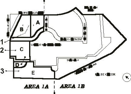
Figure 1: Site Plan
DISCUSSION: For Area 1A
Consolidated Density and Dwelling Units from Pacific Place and City Sites
There are four sites beside Granville Bridge that, while within the ODP, were not owned by Pacific Place prior to 1998 (see Appendix F6). Pacific Place consider that the densities allowed in the ODP only apply to the sites they owned. Staff have supported that position as previously reported to Council on the basis that this was the understanding at the time the ODP was framed. The sites (see Fig.1 above) include the following:
Site 1: City owned Pacific Street site, Lot 4
Site 2: City owned ( formerly Cominco owned) Canada Metals site
Site 3: Pacific Place owned (formerly Province owned) Beach Avenue site
Site 4: City owned redundant pump station site on Granville StreetThe additional density potentially attributable to these additional four sites is 8 988 m2 (96,759 sq.ft.). This additional density represents an increase of approximately 10.75% for Area 1A or 1% for the whole FCN ODP. The consolidated land area of 4 945 m2 (53,229 sq.ft.) represents an increase of approximately 16% of the land area of Area 1A.
The additional dwelling units generated by the consolidated density is 97 units. This increases the total number of residential units by approximately 10 % for Area 1A, or 1% for the whole of the FCN ODP.
As was noted in the Beach Neighbourhood rezoning issues report discussed by Council in June 1998, for any additional density, and resultant residential units, additional support facilities and amenities, such as park area, schools, daycare spaces, and public art would be assessed.
In the assessment staff took into account: the considerable public benefits of the City acquiring two non-market residential sites from Pacific Place; one at a nominal cost and one at a discount of 25% of the land cost that the City would normally have to pay; and that the City as the major owner of the unconsolidated sites is the principal beneficiary.
Staff concluded the following:
- park area: because of the limitations of land area, and that George Wainborn Park has previously been designed, staff would not expect additional park area and note that there is an overall surplus of 0.56 ha (1.4 acres) of park in the FCN (see Appendix F9, Park Requirements). Park Board staff support this approach.
- school sites: the FCN area currently includes two possible school sites (Roundhouse and International Village). The Roundhouse school is now being considered by the School Board for development and will meet anticipated school demands for the foreseeable future.
- daycare: social planning has determined that 3 additional daycare spaces should be funded to support the approved 69-space daycare approved for Area 1B. This would be funded by the City.
- public art: public art would be assessed for all additional market FSR as per normal City policy.
There are four reasons why staff recommend that consolidated density and units be added to the FCN ODP: the quality of urban design, neighbourliness and livability can be maintained for the area; the value of the consolidated density to Pacific Place can be used to further discount the cost of the non-market sites in Area 1A (see Non-market residential below); the additional value was an incentive for Pacific Place to purchase the Provincially owned site necessary to allow the Beach Avenue connection; it was the basis for the City’s purchase of the Cominco site for additional non-market residential units. Overall it optimizes the area’s development potential; and the additional units are supported by appropriate additional public benefits.
Non-Market Residential
Originally Area 1 was to be subject of a single rezoning application. During the initial design review, however, it became clear that a rezoning of the whole of Area 1 could not proceed until the property issues related to the 4 non-Pacific Place sites next to the Granville Bridge were resolved. Consequently, Area 1 was divided into Areas 1A and 1B, and Pacific Place proceeded to apply to rezone Area 1B with the expectation that the rezoning of Area 1A would proceed once the property issues were resolved.
The FCN ODP requires that 19% of the units in Area 1 be non-market units. During the rezoning of Area 1B, and in expectation that the property issues related to Area 1A would be resolved, Pacific Place asked that non-market units be shifted from Area 1B to Area 1A. Staff could not support this request until there was more certainty around the property issues related to Area 1A. When Council approved the rezoning of Area 1B on March 28, 1996, it was on condition that 236 units of non-market housing were provided in Area 1B (19% of all units in Area 1B).
Since the rezoning of Area 1B, the City acquired the former Canada Metal’s site and Pacific Place acquired the former Provincial site. Now that the City and Pacific Place are the only owners of property in Area 1A, and in the context of the detailed design for the neighbourhood, staff and Pacific Place have negotiated a distribution of non-market units to Areas 1A and 1B that achieves both the City’s and Pacific Place’s objectives. The proposal would see 4 non-market sites created in Area 1. There would be 2 large sites with a total of 246 non-market units in Area 1A, and 2 sites with a total of 186 non-market units in Area 1B for a total of 432 non-market units in Area 1 (19% of all units).
The proposal would see Pacific Place property consolidated with the City’s property in Area 1A to create the 2 large Area 1A non-market sites. There would be a shift of 50 non-market units to Area 1A from Area 1B. The total number of non-market units to be developed in Area 1 would increase by 20, and the requirement that 19% of all the units in Area 1 be non-market units would be maintained. Under the proposed arrangement, all of the non-market sites are unencumbered. They are not air-space parcels located above parking podia for adjacent sites, and consequently they can be developed independently of the adjacent projects. (Under the existing zoning for Area 1B, one of the Area 1B non-market sites could not be developed independently - see Area 1B discussion).
To compensate the City for developing its Area 1A property for non-market housing, and in recognition that without the property consolidation Pacific Place’s Area 1A sites could not be developed to their full potential, Pacific Place would give its share of one of the Area 1A sites to the City for a nominal fee and would forego 25% of the land cost that the City would otherwise have to pay for the second site. This has a real estate value of almost $3,200,000 to the City. In return, Pacific Place would be allowed to convert 65,000 sq. ft. of non-market floor area in Areas 1A and 1B to market housing, a value of $800,000, plus receive the indirect benefits of the consolidation for their development. The free land and the reduced cost for the two respective Area 1A non-market sites would allow the cost of the non-market projects to be reduced, with a greater likelihood that they would receive non-market unit allocations from the Province.
Staff supports the proposed arrangement for non-market housing because it:
- results in four good unencumbered non-market sites in Area 1,
- achieves 19% non-market housing for Area 1 as required for this area in the ODP; and
- improves the chances that the non-market housing will be funded and developed when the neighbourhood as a whole is developed.However, the non-market sites need servicing (roads and utilities) which will require the developer to have proceeded with the market sites in the area.
Beach Avenue Connection to Granville Street
The applicant proposes a road connection between the existing Beach Avenue to the west of Granville Street and the proposed Beach Avenue within the Beach Neighbourhood Area 1A. The FCN ODP states that “ A pedestrian and cycling linkage is to be provided to Beach Avenue. The option for a vehicular linkage is to be maintained.” The FCN ODP Illustrative Plan shows the new portion of Beach Avenue ending in a cul-de-sac, i.e., no through vehicular connection. This was due, in part, to Provincial ownership of the Beach Avenue connection which prevented continuation of the road at that time. Council previously advised that “it is not willing to consider through traffic, but will consider a drive-in, drive-out diverter between the existing Beach Avenue to the west of Granville Street and the proposed Beach Avenue.”
The major concern from the residents of South East Granville Slopes (SEGS) with having a through connection is of increased traffic through both SEGS and Beach Neighbourhood.
Staff reviewed several options, two of which are as follows:
Option 1(see Fig. 3): a modified connection to Granville Street that only allows a right-out-only diverter between the proposed Beach Avenue within the Beach Neighbourhood Area to the existing Beach Avenue to the west of Granville Street.
Option 2 (see Fig. 4): a cul-de-sac that would not allow any vehicular traffic between the Beach Neighbourhood and Granville Street except for emergency vehicles. However this would achieve a route for pedestrians and bicycles by means of a road dedication as envisaged in the FCN ODP.
Staff support Option 1, the modified connection that would prevent through traffic from the existing to the proposed Beach Avenue by means of right-out-only diverter for the following reasons:
- stops commuter through traffic from impacting SEGS and the Beach Avenue Neighbourhood;
- allows for pedestrian and bicycle movement between SEGS and the Beach Avenue Neighbourhood;
- allows for emergency vehicle access;
- meets subdivision requirements and minimizes pavement area;
- meets the principle of integrating the City road system while maintaining a sense of neighbourhood identity and definition; and
- supported by SEGS strata council chairpersons.The primary disadvantages with the right-out-only diverter is the potential for illegal vehicle access from Granville Street to the Beach and the increase of traffic on Granville Street going up to Pacific Street.
Option 2 (cul-de-sac) is likely to impact on the development capacity of the adjoining non-market sites. If Council selects the cul-de-sac option, the necessary re-design may result in a text amendment. It also restricts vehicular exiting options for residents, increase the amount of pavement area, and while it meets subdivision requirements, it approaches the serviceability limits of a cul-de-sac road.
The Urban Design Panel did not support the right-in/right-out proposal for the Beach Avenue extension. There was support for extending the pedestrian and bicycle routes through but strong encouragement for normalizing the street pattern and making it a through street.
The options are presented as Consideration B for Council’s decision at the Public Hearing.
Seawalk/Bikeway
At the westerly end of the seawalk/bikeway route the applicant proposes to route the combined seawalk/bikeway behind a building (building P, see Fig. 2) and not on the waters edge. This approach was illustrated in the FCN ODP. The rationale is that if the full seawalk/bikeway is required on the waters edge the building in this location may not be feasible with a potential loss in density. To enhance the public experience and connection to the water, staff have requested an additional pedestrian only seawalk of 3.6 m ( 12 ft.) and that the base of the building allows for commercial use to include such activities as restaurant and cafe uses. This secondary seawalk would be dedicated or established as Road. The applicant is in agreement with this.
Marina
Figure 5: Proposed Marina ExpansionThe proposal for Area 1A includes a marina for approximately 70 boat slips (50 existing plus expansion for 20) extending east from Granville Bridge. There is a temporary existing marina currently in this location. The proposal is to extend the existing marina out to the harbour headline and further east beside George Wainborn Park by approx. 47 m (154 ft.) up to the Park promontory (see Figure 5, Marina Proposal above, and Options below). The FCN ODP includes a marina in this location and states that it should have regard to, among other things, the following:
- “some space within marinas should be reserved for visitors;
- maintain key long views across the water;
- not overcrowd the water, especially the central basin; and
- opportunities for public boat launching should be achieved.”Staff have reviewed the proposal with respect to these criteria and comment as follows:
- visitor moorage: the applicant has proposed 200 nights per year be allocated for visiting boats which meets this public objective.
- view maintenance: the marina will have some impact on public views from the Park to the water. However, the prime long distance views are south-easterly across to the south shore of False Creek, whereas the proposed marina expansion is more to the south-west toward Granville Island where the views are shorter. Also the seawall is vertical in this location which allows reasonable views over moored boats, particularly between high tides.
- not overcrowding the water; while covering more water with boats is always sensitive, the location of this marina is outside the central basin and therefore overcrowding is not a primary concern although expansion out to the harbour headline does make the channel between the proposed marina and Granville Island narrower.
- public boat launching; there are very limited opportunities for public boatlaunching from car trailers in Area 1A without bringing new vehicular access down to the waterfront. This would significantly impact either the Park, marina or residential design being proposed. Therefore, staff believe that other parts of the Creek are better suited for this activity.
There are three other built, or planned, marina facilities on the north shore of False Creek. These are: the approved Quayside marina and it’s proposed expansion; Plaza of Nations marina; and the Abbott Street marina proposed in the FCN ODP. The Blueways program includes a policy to encourage non-power craft use east of Cambie Bridge. By agreeing to Pacific Place proposal to expanding the Quayside Marina, the City would anticipate that the potential development of the Abbott Street marina may preclude motorised boats and emphasise hand powered boats. A shorter range concept is to increase the visitor moorage available in the Creek. With these concepts in mind, staff considered two main options (see Figure 4, Marina Proposal and Options above) for the Beach Neighbourhood which are as follows:
Option 1: Expansion from the existing temporary marina of approximately 50 boat slips to approximately 70. The applicant proposes to expand out to the harbour headline (an expansion of approximately 8 boat slips) and an easterly expansion (an expansion of approximately 12 boat slips) to the existing promontory of approximately 50 m ( 164 ft.) , i.e., boats would be moored in front of 66% of the Park frontage, an increase of approximately 15% above the existing.
Staff support Option 1, which allows expansion to the marina, as it provides a balance between the public and private interests on the following basis:
- that the additional marina area and moorage spaces are appropriate with respect to Council policy regarding increasing permanent moorage capacity (Blueways Program Policies and Guidelines) and the concept of the encouragement of non-motorized craft at the east end of False Creek in Area 6 of the FCN ODP;
- that 200 visitor nights per year be allocated for visiting boats*; and
- that the False Creek Yacht Club (FCYC) would provide on their adjacent westerly site a visitor centre, make available to the public their pump-out station, laundromat and toilet facilities, and allow a right-of-way across their property in approximate alignment with the current informal pedestrian route adjacent, or close to, the water. A condition of this proposal is that access to this Marina site will be provided from the adjacent westerly FCYC land site owned by the Province, and that all servicing for this site is to be provided from the westerly FCYC site. *
* The intent is that these two items would be secured by legal arrangements and managed by FCYC. However, the FCYC lease the land they occupy from the Province and the Province would have to agree to the legal arrangements. This will have to be negotiated in the future and there is no certainty that the Province will agree. The other complication is that at this time there is no agreement between Pacific Place and the FCYC as to whether they will lease or buy the marina area.
(FCYC currently has a 5-year lease for the marina water lot from Pacific Place.)
Therefore, while staff believe it is appropriate to consider approving the marina expansion as part of this rezoning it would be done on the basis of a no-development covenant that would require the above conditions be met before the expansion could occur.
In the event that Pacific Place is unable to secure the necessary legal arrangements with either the FCYC, or the Province, Pacific Place would proceed with replanning the area and may require a text amendment for Area 1A that would require marina access, servicing and the public objectives (such as visitor nights, visitor centre, pump out station and toilet facilities where appropriate) from the upland Pacific Place sites. The text amendment would, if approved, significantly change the proposed plan, particularly building P (see Fig. 2) and may reduce achievable density.
Option 2: No expansion to the marina. This option would retain the existing marina which extends along the George Wainborn Park frontage of 175 m (574 ft.) for approximately 70 m (230 ft.), i.e. boats would be moored in front of 40% of the Park frontage. Staff would not propose reserved visitor moorage with this option as the status quo business plan does not include it.
Public commentary on the marina expansion has been divided. Park Board staff support the marina expansion.
The proposed Marina expansion will also occupy a portion of dedicated Road along the Shoreline Protection Works, and will also occupy a portion of the Richards Street outfall right-of-way. An encroachment agreement, or such other agreement, will be required which will provide for City access for maintenance, inspection, or replacement of the shoreline and outfall, and may involve temporary relocations of the Marina if necessary at no cost to the City.
There have been some objections from the public to any marina expansion because of its impact on views from the Park and additional water coverage. Therefore, Options 1, and 2 are presented as Consideration C for Council’s decision at the Public Hearing.
Staff note that the marina expansion, if approved, may not occur for 4-8 years as it would have to be subsequent to the necessary shoreline works in this area. When the marina is redeveloped temporary moorage will be accommodated in Area 1B. A temporary encroachment agreement, or such other agreement, to allow this occupation of the Road along the Area 1B shoreline would have to be negotiated.
Tower Heights
The ODP illustrated 4 towers (10 storeys or more in height) in Area 1A with extensive streetwall buildings of up to approximately 8 storeys. The applicant proposes 3 more towers with a proportional decrease in the height of the streetwall buildings. There are four factors influencing the increase of tower built form as follows:
· the desire to decrease streetwall heights which have been considered as generating too dominant a scale and blocking views at lower levels and, in the case of the crescent building form, needing to match the Council approved crescent height in Area 1B;
· the desire to accommodate the additional density from the consolidated sites;
· a general public preference for slimmer towers; and
· a 16% increase to Area 1A land area from consolidation. Staff have reviewed the proposal with respect to view and sun impact, building scale and livability and support the proposal.
Because of the substantial slope of the area from a high point on Pacific Street/Boulevard down to False Creek staff are recommending a minor change to the CD-1 By-law. The change would allow relaxation of permitted heights with the intent to ensure the appropriate public realm and livability relationships between ground level residential units, principal building entrances and the surrounding grade levels, noting that the actual maximum tower heights in the CD-1 by-laws will remain unchanged.
Marina and Parking Tunnel Agreements
As a condition of the Area 1A rezoning, Pacific Place will be transferring lands containing the shoreline protection works and walkway to the City for dedication or establishment as Road. The shoreline consists of a sloped bank extending below the water that is usable as marina. The primary reason for dedication to the City is to ensure access and control of the area for maintenance purposes.
Staff support the use of the water area because it is land being dedicated to the City as part of the shoreline. This water area would not otherwise be utilized by the City on a regular basis except for maintenance. Staff feel it is acceptable to allow marina use of the water over those lands at a nominal cost, subject to conditions for City access, maintenance, reconstruction of the shoreline.
The main shoreline walkway, at the westerly end of Area 1A, is directed inland behind Building “P” to connect to the SEGS walkways. To resolve potential conflicts between vehicular access to Building “P” and the shoreline walkway, the parking access is proposed to be provided from the adjacent Building “O” through an underground tunnel beneath the shoreline walkway. A legal agreement for the design, construction, and maintenance of the tunnel is a requirement of the zoning enactment. As Pacific Place will be dedicating the shoreline walkway to the City, staff feel it is acceptable to allow their use of the lands at a nominal cost.
In addition, City Council has previously approved the use of City road, transferred the City by the developer as part of rezoning, for the purposes of parking tunnels and marina uses over water area at a nominal fee in the Bayshore and Coal Harbour developments.
DISCUSSION: for Area 1B Text Amendment
Non-Market Residential
Area 1B was zoned CD-1 to accommodate 236 non-market residential units. The applicant proposes transferring 50 of these non-market units from Area 1B to Area 1A, and transferring 50 market residential units from Area 1A to 1B, for two main reasons. First, to accomplish the public objective of achieving unencumbered non-market sites, the planning of the two non-market buildings, and their structured parking, were rationalized with the outcome that the footprint of these two buildings were reduced. Second, one wing of one of the buildings would have had difficulty in meeting fire access requirements. While it was determined that adding 1 extra floor to one of the buildings had negligible impact on surrounding development, not all the building area could be maintained on the site. Overall these changes produce more viable and livable non-market residential buildings.
Staff note that the transfer of the 50 non-market units from Area 1B to Area 1A was contemplated at the time of the rezoning of Area 1B and the non-market housing agreements for Area 1B allows for this transfer.
Tower Heights
The applicant proposes increases in tower heights. When Area 1B was originally rezoned Council reduced the height of three buildings as follows: the crescent building form around the northerly part of the Park from 6 to 3-storeys; the non-market building (building F, see Fig. 2) wing from 4 to 2-storeys; and the landmark tower (building A, see Fig.2) wing from 4 to 2-storeys. Those changes were to allow the residents of Pacific Point (to the north across Pacific Street) better views. Those changes reduced the density of the rezoning and Council noted at the time that this density may not be achievable in the area. The applicant’s proposed tower heights would recapture that lost density.
The proposal is to modestly add to the height of some buildings, as follows (see Fig. 2):
- building B, 2 storeys (from 26 to 28 storeys)
- building G, 2 storeys (from 22 to 24 storeys)
- building J, 4 storeys (from 14 to 18 storeys)The rationale for adding these storeys is that the allowable density could not be effectively accommodated elsewhere on the site and that any view, shadow and scale impacts are acceptable.
Public Comment and Urban Design Panel Review
There were three public meetings held (see Appendix G1) and public correspondence has been received. In summary, public opinion was mixed on the requested tower heights.
The Urban Design Panel unanimously supported the application. However, they were concerned that the three-storey height of the crescent podium building is extremely weak in comparison to the very high towers. While recognizing that this had previously been agreed to by Council, and unlikely to be revisited, the Panel felt very strongly that it remain a major consideration for the success of the urban design of this project. (See Appendix G8 for complete UDP comments.)
CONCLUSION
Staff support the rezoning proposal for Area 1A. Staff consider the application successfully meets overall City public objectives, particularly noting the following:
- the delivery of two large, livable, non-market residential sites;
- a successful residential urban design that is both neighbourly and very livable, particularly along the edge of George Wainborn Park; and
- the completion of the seawalk/bikeway between George Wainborn Park and Granville Street.There are two principal decisions for Council which are: the type of connection between Beach Neighbourhood and Granville Street; and whether the expansion of the existing marina is appropriate.
Staff also support the proposed text amendment and amendments to the FCN ODP. The Director of Central Area Planning recommends the application be referred to a Public Hearing, and approved, subject to the proposed conditions presented in Appendix C. The applicant is in agreement with all the recommended conditions.
It is important to note that because the approvals for both Area 1A and Area 1B involve the transfer of units from one area to another, approval of each Area is contingent on approval of the other. Therefore, if Area 1B is not approved, Area 1A should also not be approved, and vice versa.
* * * * *

Table of Contents for Appendices
Appendix A: Draft CD-1 By-law for Area 1A
Appendix B: Draft CD-1 By-law for Area 1B (revisions to existing CD-1 By-law
#7675)
Appendix C: Draft Conditions of Rezoning
Appendix D: Draft Design Guidelines (for Area 1A and 1B combined)
Appendix E: Proposed FCN Amendments:
Appendix F: Additional Information
F1 Site and Context for Area 1A
F2 Site and Context for Area 1B
F3 Proposed Development for Area 1A
F4 Proposed Development for Area 1B
F5 Density for Area 1A and 1B
F6 Consolidated ODP Density and Residential Units From Non-Pacific Place Sites
F7 Non-Market Residential for Area 1A and 1B
F8 Overall Non-market and Market Residential Units for Area 1A and 1B
F9 Park Requirements
F10 Soils
F11 Social and Environmental Implications
F12 Public Art
Appendix G: Comments from the Public, Reviewing Agencies and the Applicant
G1 Public Input
G2 General Manager of Engineering Services Comments
G3 Health Department Comments
G4 Housing Centre Comments
G5 Social Planning Comments
G6 Police Department Comments
G7 Fire Department Comments
G8 Urban Design Panel
G9 Blueways Comments
G10 Disabled Committee Comments
G11 Seniors Committee Comments
G12 Bicycle Committee Comments
G13 Applicant’s Comments
Appendix H: Applicant, Property and Development Proposal Information
600 Pacific (Area 1A) Draft By-law
BY-LAW NO._______
A By-law to amend
By-law No. 3575,
being the Zoning and Development By-law
THE COUNCIL OF THE CITY OF VANCOUVER, in open meeting assembled, enacts as follows:
1. The "Zoning District Plan" annexed to By-law No. 3575 as Schedule "D" is hereby amended according to the plan marginally numbered _____ and attached to this By-law as Schedule "A", and in accordance with the explanatory legends, notations and references inscribed thereon, so that the boundaries and districts shown on the Zoning District Plan are varied, amended or substituted to the extent shown on Schedule "A" of this by-law, and Schedule "A" of this by-law is hereby incorporated as an integral part of Schedule "D" of By-law No. 3575.
2. Definitions
Words in this By-law shall have the meaning assigned to them in the Zoning and Development By-law, except as provided below.
Core-need Household means a household which would have to spend more than 30 percent of its annual gross income on shelter (including utilities) in order to live in an average market rental unit which is adequate and suitable for its basic needs.
Public Ferry Dock means a dock located on a water lot providing water access for public ferry transportation, but does not include any private marina or berth uses.
3. Uses
The area shown included within the heavy black outline on Schedule "A" shall be more particularly described as CD-1(___), and the only uses permitted within the outlined area, subject to approval by Council of the form of development and to
such conditions, guidelines and policies adopted by Council, and the only uses for which development permits will be issued are:
(a) Dwelling Units in multiple dwellings or in conjunction with any of the uses listed below, not exceeding 1,023 dwelling units provided that:
(i) a minimum of 17 percent of the units (but not including the units provided under clause (ii) below) shall be for family housing, all of which shall be designed in accordance with the Council-adopted "High-Density Housing for Families With Children Guidelines";
(ii) a minimum of 16.13 percent of the units shall be provided through government funded programs targeted for core-need households or for such non-market family housing programs or initiatives as City Council may generally define or specifically approve from time to time, and shall be designed for family housing consistent with clause (i) above; and
(iii) a minimum of 7.92 percent of the units shall be provided through government funded programs targeted for core-need households or for such non-market non-family housing programs or initiatives as City Council may generally define or specifically approve from time to time, but need not be designed consistent with clause (i) above;
(b) Retail Uses, but not including Gasoline Station - Full Serve, Gasoline Station - Split Island, and Vehicle Dealer;
(c) Service Uses, but not including Auction Hall, Bed and Breakfast Accommodation, Body-rub Parlour, Drive-through Service, Funeral Home, Hotel, Laboratory, Laundry or Cleaning Plant, Motor Vehicle Repair Shop, Motor Vehicle Wash, Production or Rehearsal Studio, Repair Shop - Class A, Restaurant - Drive-in, School - Vocational or Trade, and Sign Painting Shop;
(d) Office Uses;
(e) Child Day Care Facility;
(f) Cultural and Recreational Uses, but not including Arcade, Golf Course or Driving Range, Riding Ring, Stadium or Arena, and Zoo or Botanical Garden;
(g) Public Ferry Dock;
(h) Parking Uses;
(i) Public Authority Use;
(j) Marina Uses;
(k) Accessory Uses customarily ancillary to the above uses;
(l) Interim Uses not listed above and Accessory Uses customarily ancillary thereto, provided that:
(i) the Development Permit Board considers that the use will be compatible with and not adversely affect adjacent development that either exists or is permitted by this By-law;
(ii) the Development Permit Board is satisfied that the use can be easily removed and is of low intensity or low in capital investment;
(iii) the Development Permit Board is satisfied that there is no risk to the public from contaminated soils either on or adjacent to the subject site; and
(iv) development permits are limited in time to periods not exceeding three years.
4. Sub-Areas
The district shall comprise three sub-areas containing five sites approximately as illustrated in Diagram 1 below.
Diagram 1
5. Floor Area and Density
5.1 The total floor area for uses listed in Table 1 must not exceed the totals set opposite such uses, and any use permitted in section 3, but not listed in Table 1, is not limited by this sub-section 5.1.
TABLE 1
USE |
MAXIMUM FLOOR AREA |
Residential Uses Retail, Service and Office Uses |
92 600 m2 690 m2 |
5.2 The following will be included in the computation of floor area:
(a) all floors having a minimum ceiling height of 1.2 m., both above and below ground level, to be measured to the extreme outer limits of the building.
5.3 The following will be excluded in the computation of floor area:
(a) open residential balconies or sundecks and any other appurtenances which, in the opinion of the Director of Planning, are similar to the foregoing, provided that the total area of all exclusions does not exceed eight percent of the residential floor area being provided;
(b) patios and roof gardens, provided that the Director of Planning first approves the design of sunroofs and walls;
(c) the portion of a floor used for heating and mechanical equipment or other uses similar to the foregoing;
(d) the portion of a floor used for off-street parking and loading that for each parking area, is at or below the base surface;
(e) undeveloped floor areas located above the highest storey or half-storey with a ceiling height of less than 1.2 m and to which there is no permanent means of access other than a hatch;
(f) residential storage space provided that where such space is located at or above the base surface, the maximum exclusion shall be 3.7 m² per dwelling unit;
(g) amenity areas accessory to residential use, including the requirement of section 7.3 of this by-law, provided that the total area excluded which is at or above the base surface does not exceed 8 000 m²; and
(h) child day care facilities.
5.4 The Director of Planning may permit the following to be excluded in the computation of floor area:
(a) enclosed residential balconies, provided that the Director of Planning first considers all applicable policies and guidelines adopted by Council and approves the design of any balcony enclosure subject to the following:
(i) the total area of all open and enclosed balcony or sundeck exclusions does not exceed eight percent of the residential floor area being provided; and
(ii) no more than fifty percent of the excluded balcony floor area may be enclosed;
(b) windows recessed into the building face to a maximum depth of 160 mm, except that the Development Permit Board may allow a greater depth in cases where it improves building character.
5.5 The total floor area in each sub-area for the uses listed in Table 2 must not exceed the applicable totals set opposite such uses, and any use permitted by section 3 but not listed in Table 2 is not limited by this sub-section 5.5.
TABLE 2
MAXIMUM FLOOR AREA (in square meters)
|
|
SUB-AREA 1 (from Diagram 1) | |
Site A |
Site B | |
Residential Uses Retail, Service and
|
47 090 N/A |
12 524 N/A |
|
USE |
SUB-AREA 2 (from Diagram 1) | |
Site C |
Site D | |
Residential Uses Retail, Service and
|
28 663 N/A |
4 323 690 |
|
USE |
SUB-AREA 3 (from Diagram 1) |
Site E | |
Residential Uses Retail, Service and
|
N/A N/A |
5.6 Notwithstanding sub-section 5.5, the Development Permit Board may permit a maximum of 2 000 m² of residential floor area to be transferred from any site in sub-area 1 or sub-area 2 to any other site in sub-area 1 or sub-area 2.
6. Height
6.1 The maximum building height measured above the base surface, but excluding the mechanical penthouse and roof, is as set out in Table 4.
6.2 The Development Permit Board may permit an increase in the maximum height of a building where it is satisfied that the relaxation will enhance the livability of residential units and provided it considers all applicable policies and guidelines adopted by Council, subject to the following:
(a) the floor level of ground floor residential units, the principal entrance and the entrance lobby, are a maximum of 2.0 m above the building grades of the closest street; and
(b) the height measured from the lobby floor level must not exceed the maximum height in Table 4.
TABLE 4
MAXIMUM HEIGHT (in metres)
SUB-AREA 1 (from Diagram 1) | ||
Site A |
Site B | |
Maximum Height |
91.0 |
50.0 |
SUB-AREA 2 (from Diagram 1) | ||
Site C |
Site D | |
Maximum Height |
71.0 |
28.0 |
|
|
SUB-AREAS 3 (from Diagram 1) |
Site E | |
Maximum Height |
N/A |
7. Residential Component
7.1 Any development which combines residential with any other use shall have separate and distinct means of pedestrian access to the residential component from streets and on-site parking.
7.2 Private, semi-private, and public outdoor spaces shall be clearly separated and distinguished from each other.
7.3 In every building intended to contain core-need households a community room shall be provided.
8. Off-Street Parking
8.1 Off-street parking must be provided, developed and maintained in accordance with the applicable provisions of the Parking By-law, except that:
(a) retail uses shall provide a minimum of 1 space for each 100 m² of gross floor area up to 300 m², then 1 space for each 50 m² of gross floor area, subject to a maximum number of spaces 10 percent greater than the minimum calculated using this clause;
(b) restaurant uses shall provide a minimum of 1 space for each 50 m² of gross floor area for the first 100 m² of gross floor area, then 1 space for 10 m² of gross floor area for the next 400 m² to a total of 500 m² of gross floor area, then 1 space for each 20 m² over 500 m² of gross floor area, subject to a maximum number of spaces 10 percent greater than the minimum calculated using this clause;
(c) multiple dwelling uses, not including units designated for core-need subsidized seniors housing or family non-market housing, shall provide a minimum of 1 space for each 200 m² of gross floor area plus 0.9 spaces for each dwelling unit, except that no more than 2.2 spaces per dwelling unit need be provided while family non-market housing shall provide a minimum of 1.1 spaces for each dwelling unit; and
(d) office uses shall provide a minimum of 1 space for each 93 m² of gross floor area with a maximum of 1 space for each 80 m² of gross floor area.
8.2 The Director of Planning, in the exercise of his jurisdiction, may relax the provisions of this By-law in any case where literal enforcement would result in unnecessary hardship relating to the number of off-street parking and passenger spaces required.
8.3 The Director of Planning, before granting any relaxation pursuant to section 8.2, shall be satisfied that any property owner likely to be adversely affected is notified. Such notification shall be in the form appropriate to the circumstances.
8.4 Multiple-Use Developments
For the purposes of this section uses with the same formula for determining required parking spaces shall be considered to be of the same class. If a development contains parking for more than one use as listed in section 4.2 of the Parking By-law, the total number of parking spaces shall be the sum of the parking spaces required for the various classes of uses calculated separately and, unless otherwise permitted by the Director of Planning, in consultation with the City Engineer, taking into account the time-varying demand of uses, a parking space required for one use shall be deemed not to meet the requirement for any other use in that development.
8.5 Parking Space Requirement Exemptions
The required number of off-street parking spaces need not be provided where, subsequent to original construction of a building, any additions, alterations or change in use would, in total, result in an increase of less than 10 percent of the number of spaces required for the originally constructed building before any addition, alteration or change in use.
9. Off-Street Loading
9.1 Off-street loading must be provided, developed and maintained in accordance with the applicable provisions of the Parking By-law except that one loading bay shall be provided for every 200 dwelling units.
9.2 The Director of Planning, in the exercise of his jurisdiction, may relax the provisions of this By-law in any case where literal enforcement would result in unnecessary hardship relating to the number of loading spaces required.
9.3 The Director of Planning, before granting any relaxation pursuant to section 9.2, shall be satisfied that any property owner likely to be adversely affected is notified. Such notification shall be in the form appropriate to the circumstances.
9.4 Multi-Use Developments
For the purposes of this section, uses with the same formula for determining required loading spaces shall be considered to be of the same class. If a development contains more than one use as defined in section 5.2 of the Parking By-law, the total number of loading spaces shall be the sum of the loading spaces required for the various classes of uses calculated separately and, unless otherwise permitted by the Director of Planning, in consultation with the City Engineer, taking into account the time-varying demand of uses, a loading space required for one use shall be deemed not to meet the requirement for any other use in that development.
9.5 Loading Space Requirement Exemptions
The required number of off-street loading spaces need not be provided where, subsequent to original construction of a building, any additions, alterations or change in use would, in total, result in an increase of less than 10 percent of the number of spaces required for the originally constructed building before any addition, alteration or change in use.
10. Acoustics
All development permit applications require evidence in the form of a report and recommendations prepared by a person trained in acoustics and current techniques of noise measurement demonstrating that the noise levels in those portions of the dwelling units listed below shall not exceed the noise level set opposite such portions. For the purposes of this section the noise level is the A-weighted 24-hour equivalent (Leq) sound level and will be defined simply as noise level in decibels.
PORTIONS OF DWELLING UNITS NOISE LEVELS(DECIBELS)
Bedrooms 35
Living, dining, recreation rooms 40
Kitchen, bathrooms, hallways 45
12. This By-law comes into force and takes effect on the date of its passing.
DONE AND PASSED in open Council this day of 1999.
__________________________
Mayor
__________________________
City Clerk
500 Pacific Street (Area 1B) Text Amendment
(revisions to existing CD-1 By-law #7675 indicated as follows:
- strikeout deleted text
- Italics inserted text
BY-LAW NO. 7675
A By-law to amend
By-law No. 3575,
being the Zoning and Development By-law
THE COUNCIL OF THE CITY OF VANCOUVER, in open meeting assembled, enacts as follows:
1. The "Zoning District Plan" annexed to By-law No. 3575 as Schedule "D" is hereby amended according to the plan marginally numbered Z-451(c) and attached to this By-law as Schedule "A", and in accordance with the explanatory legends, notations and references inscribed thereon, so that the boundaries and districts shown on the Zoning District Plan are varied, amended or substituted to the extent shown on Schedule "A" of this by-law, and Schedule "A" of this by-law is hereby incorporated as an integral part of Schedule "D" of By-law No. 3575.
2. Definitions
Words in this By-law shall have the meaning assigned to them in the Zoning and Development By-law, except as provided below.
Core-need Household means a household which would have to spend more than 30 percent of its annual gross income on shelter (including utilities) in order to live in an average market rental unit which is adequate and suitable for its basic needs.
Public Ferry Dock means a dock located on a water lot providing water access for public ferry transportation, but does not include any private marina or berth uses.
3. Uses
The area shown included within the heavy black outline on Schedule "A" shall be more particularly described as CD-1(366), and the only uses permitted within the outlined area, subject to approval by Council of the form of development and to
such conditions, guidelines and policies adopted by Council, and the only uses for which development permits will be issued are:
(a) Dwelling Units in multiple dwellings or in conjunction with any of the uses listed below, not exceeding 1,243 dwelling units provided that:
(i) a minimum of 17 percent of the units (but not including the units provided under clause (ii) below) shall be for family housing, all of which shall be designed in accordance with the Council-adopted "High-Density Housing for Families With Children Guidelines";
(ii) a minimum of 7.24 percent of the units shall be provided through government funded programs targeted for core-need households or for such non-market family housing programs or initiatives as City Council may generally define or specifically approve from time to time, and shall be designed for family housing consistent with clause (i) above; and
(iii) a minimum of 7.72 percent of the units shall be provided through government funded programs targeted for core-need households or for such non-market non-family housing programs or initiatives as City Council may generally define or specifically approve from time to time, but need not be designed consistent with clause (i)above;
(b) Retail Uses, but not including Gasoline Station - Full Serve, Gasoline Station - Split Island, and Vehicle Dealer;
(c) Service Uses, but not including Auction Hall, Bed and Breakfast Accommodation, Body-rub Parlour, Drive-through Service, Funeral Home, Hotel, Laboratory, Laundry or Cleaning Plant, Motor Vehicle Repair Shop, Motor Vehicle Wash, Production Studio,
Repair Shop - Class A, Restaurant - Drive-in, School - Vocational or Trade, and Sign Painting Shop;
(d) Office Uses;
(e) Child Day Care Facility;
(f) Cultural and Recreational Uses, but not including Arcade, Golf Course or Driving Range, Riding Ring, Stadium or Arena, and Zoo or Botanical Garden;
(g) Public Ferry Dock;
(h) Parking Uses;
(i) Public Authority Use;
(j) Accessory Uses customarily ancillary to the above uses;
(k) Interim Uses not listed above and Accessory Uses customarily ancillary thereto, provided that:
(i) the Development Permit Board considers that the use will be compatible with and not adversely affect adjacent development that either exists or is permitted by this By-law;
(ii) the Development Permit Board is satisfied that the use can be easily removed and is of low intensity or low in capital investment;
(iii) the Development Permit Board is satisfied that there is no risk to the public from contaminated soils either on or adjacent to the subject site; and
(iv) development permits are limited in time to periods not exceeding three years.
4. Sub-Areas
The district shall comprise four sub-areas, containing six sites approximately as illustrated in Diagram 1 below.
Diagram 1 (revised)
5. Floor Area and Density
5.1 The total floor area for uses listed in Table 1 must not exceed the totals set opposite such uses, and any use permitted in section 3, but not listed in Table 1, is not limited by this sub-section 5.1.
TABLE 1
USE |
MAXIMUM FLOOR AREA |
Residential Uses Retail, Service and Office Uses |
130 414 m² 1260 m² |
5.2 The following will be included in the computation of floor area:
(a) all floors having a minimum ceiling height of 1.2 m, both above and below ground level, to be measured to the extreme outer limits of the building.
5.3 The following will be excluded in the computation of floor area:
(a) open residential balconies or sundecks and any other appurtenances which, in the opinion of the Director of Planning, are similar to the foregoing, provided that the total area of all exclusions does not exceed eight percent of the residential floor area being provided;
(b) patios and roof gardens, provided that the Director of Planning first approves the design of sunroofs and walls;
(c) the portion of a floor used for heating and mechanical equipment or other uses similar to the foregoing;
(d) the portion of a floor used for off-street parking and loading that for each parking area, is at or below the base surface;
(e) undeveloped floor areas located above the highest storey or half-storey with a ceiling height of less than 1.2 m and to which there is no permanent means of access other than a hatch;
(f) residential storage space provided that where such space is located at or above the base surface, the maximum exclusion shall be 3.7 m² per dwelling unit; and
(g) amenity areas accessory to residential use, including the requirement of section 7.3 of this by-law, provided that the total area excluded which is at or above the base surface does not exceed 10 000 m².
(h) child daycare facilities
5.4 The Director of Planning may permit the following to be excluded in the computation of floor area:
(a) enclosed residential balconies, provided that the Director of Planning first considers all applicable policies and guidelines adopted by Council and approves the design of any balcony enclosure subject to the following:
(i) the total area of all open and enclosed balcony or sundeck exclusions does not exceed eight percent of the residential floor area being provided; and
(ii) no more than fifty percent of the excluded balcony floor area may be enclosed;
(b) windows recessed into the building face to a maximum depth of 160 mm, except that the Development Permit Board may allow a greater depth in cases where it improves building character.
5.5 The total floor area in each sub-area for the uses listed in Table 2 must not exceed the applicable totals set opposite such uses, and any use permitted by section 3 but not listed in Table 2 is not limited by this sub-section 5.5.
TABLE 2
MAXIMUM FLOOR AREA (in square metres)
|
|
SUB-AREA 1 (from Diagram 1) | |
Site A |
Site B | |
Residential Uses Retail, Service and
|
38 567 N/A |
48 042 1 260 |
|
USE |
SUB-AREA 2 (from Diagram 1) | |
Site C |
Site D | |
Residential Uses Retail, Service and
|
30 696 N/A |
13 109 N/A |
|
USE |
SUB-AREAS 3 and 4 (from Diagram 1) | |
Site E |
Site F | |
Residential Uses Retail, Service and
|
N/A N/A |
N/A N/A |
5.6 Notwithstanding sub-section 5.5, the Development Permit Board may permit a maximum of 2 000 m² of residential floor area to be transferred from any site in sub-area 1 or sub-area 2 to any other site in sub-area 1 or sub-area 2.
6. Height
6.1 The maximum building height measured above the base surface, but excluding the mechanical penthouse and roof, is as set out in Table 4.
6.2 The Development Permit Board may permit an increase in the maximum height of a building where it is satisfied that the relaxation will enhance the livability of residential units and provided it considers all applicable policies and guidelines adopted by Council, subject to the following:
(a) the floor level of ground floor residential units, the principal entrance and the entrance lobby, are a maximum of 2.0 m above the building grades of the closest street; and
(b) the height measured from the lobby floor level must not exceed the maximum height in Table 4.
TABLE 4
MAXIMUM HEIGHT (in metres)
SUB-AREA 1 (from Diagram 1) | ||
Site A |
Site B | |
Maximum Height |
91.0 |
110.0 |
SUB-AREA 2 (from Diagram 1) | ||
Site C |
Site D | |
Maximum Height |
71.0 |
53.0 |
|
|
SUB-AREAS 3 and 4 (from Diagram 1) | |
Site E |
Site F | |
Maximum Height |
N/A |
N/A |
7. Residential Component
7.1 Any development which combines residential with any other use shall have separate and distinct means of pedestrian access to the residential component from streets and on-site parking.
7.2 Private, semi-private, and public outdoor spaces shall be clearly separated and distinguished from each other.
7.3 In every building intended to contain core-need households a community room shall be provided.
8. Off-Street Parking
Off-street parking must be provided, developed and maintained in accordance with the applicable provisions of the Parking By-law, except as follows:
(a) retail uses shall provide a minimum of 1 space for each 100 m² of gross floor area up to 300 m², then 1 space for each 50 m² of gross floor area, subject to a maximum number of spaces 10 percent greater than the minimum calculated using this clause;
(b) restaurant uses shall provide a minimum of 1 space for each
50 m² of gross floor area for the first 100 m² of gross floor area, then 1 space for 10 m² of gross floor area for the next 400 m² to a total of 500 m² of gross floor area, then 1 space for each 20 m² over 500 m² of gross floor area, subject to a maximum number of spaces 10 percent greater than the minimum calculated using this clause;
(c) multiple dwelling uses, not including units designated for core-need subsidized seniors housing or family non-market housing, shall provide a minimum of 1 space for each 200 m² of gross floor area plus 0.9 spaces for each dwelling unit, except that no more than 2.2 spaces per dwelling unit need be provided while family non-market housing shall provide a minimum of 1.1 spaces for each dwelling unit; and
(d) office uses shall provide a minimum of 1 space for each 93 m² of gross floor area with a maximum of 1 space for each 80 m² of gross floor area.
9. Off-Street Loading
Off-street loading must be provided, developed and maintained in accordance with the applicable provisions of the Parking By-law except that one loading bay shall be provided for every 200 dwelling units.
10. Acoustics
All development permit applications require evidence in the form of a report and recommendations prepared by a person trained in acoustics and current techniques of noise measurement demonstrating that the noise levels in those portions of the dwelling units listed below shall not exceed the noise level set opposite such portions. For the purposes of this section the noise level is the A-weighted 24-hour equivalent (Leq) sound level and will be defined simply as noise level in decibels.
PORTIONS OF DWELLING UNITS NOISE LEVELS (DECIBELS)
Bedrooms 35
Living, dining, recreation rooms 40
Kitchen, bathrooms, hallways 45
11. This By-law comes into force and takes effect on the date of its passing.
Beach Neighbourhood (Site 1A and 1B)
DRAFT CONDITIONS OF REZONING
Some of the conditions will be extensions, or additions, to agreements secured for Beach Neighbourhood Area 1B.
NOTE: These are draft conditions which are subject to change and refinement by staff prior to the finalization of the agenda for Public Hearing.
SCHEMATIC (a) THAT the proposed schematic development be approved
DEVELOPMENT by Council in principle, generally as prepared by Pacific Place Developments Corp. Planning and Design Team and stamped “Received, City of Vancouver Planning Department July 31 1998”, specifically in relation to the siting of buildings, development of ground plane, general building heights and massing, providing that the Development Permit Board may allow alterations to this form of development when approving the detailed scheme of development with guidance from (b) and (c) below;
DESIGN (b) THAT the proposed revised design guidelines entitled “Beach
GUIDELINES Neighbourhood CD-1 Guidelines” be adopted by resolution of Council at the time of enactment of the CD-1 By-law.
DEVELOPMENT (c) THAT prior to the final approval by Council
APPLICATIONS of the detailed form of development for each portion of the project, the applicant shall obtain approval of a development application by the Development Permit Board who shall have regard to design guidelines approved under (b) and particular regard to the following:
(i) design development to the mews to ensure its configuration, treatment, function, and adjacent built form provide an appropriate public R.O.W.; and
(ii) provide a Tree Management Plan by a Certified Arborist that includes:
1. survey of all trees over 8" in diameter;
2. tree retention, relocation and removal plan based on their existing condition and their relationship to the proposed development.
CRIME PREVENTION (iii) create a vital street face adjacent to the Granville Street THROUGH Bridge and the Seymour Street off ramp, taking into
ENVIRONMENTAL account pedestrian pathway concerns, with;
DESIGN (CPTED) - a landscaped pedestrian setback,
(CPTED) - residential units on the ground floor facing the street with individual entrances.
REZONING (d) THAT the text amendment for Area 1B and the rezoning of Area 1A shall be enacted concurrently.
NON-MARKET (e) THAT Council require 19% of the total units on sites in
HOUSING Areas 1A and 1B for non-market housing, located on
AMOUNT four or more sites.
MEWS PUBLIC (f) THAT Council require a statutory right-of-way for full
ACCESS public access to the site 1A mews linking Pacific Street to Beach Avenue.
ENERGY (g) THAT Council require the provision of low flow
EFFICIENT toilets, shower heads and faucets as standard
FEATURES features in Beach Neighbourhood, as and when required by the Plumbing By-law;
AGREEMENTS (h) THAT, prior to the enactment of the CD-1 By-law, the property owner shall, at no cost to the City:
SOILS (i) Obtain and submit to the City copies of all soils studies
REMEDIATION and the consequential Remediation Plan, approved by
(Pacific Place) the Ministry of Environment. Enter into or cause to be entered into by the Province of British Columbia, agreements satisfactory to the Director of Legal Services, which may include long-term leases of park from the Province, providing for the remediation of any contaminated soils on the Beach Neighbourhood Area 1 in accordance with a Remediation Plan approved by the Ministry of Environment and acceptable to the City, providing security satisfactory to the Director of Legal Services for the completion of remediation and indemnifying the City, the Approving Officer and the Park Board against any liability or costs which may be incurred as a result of the presence of contaminated soils on the site. Provided however, Pacific Place Holdings Ltd. or the Province shall not be responsible for soil remediation costs for lands within Area 1A owned by the City at the date of this report, except Pacific Place Holdings Ltd. shall be responsible for its share, as defined in the Infrastructure Agreement dated April 27, 1984, of the soil remediation costs of the City-owned old pump-station lands Area 1A.
SOILS (ii) Submit to the City a remediation plan for all newly
REMEDIATION dedicated streets and utility rights-of-way required to
(Road) serve the subject site, including utility construction plans compatible with the accepted remediation plan; together with any agreements deemed necessary by the City Engineer providing for the construction and installation of remedial works, including monitoring systems for, among other things, water discharges and ground water flows; and any other remedial works or systems required by the City Engineer all to the satisfaction of the City Engineer and the Director of Legal Services;
SOILS (iii) Execute an Indemnity Agreement, satisfactory to the
INDEMNITY Director of Legal Services, providing for security to the satisfaction of the Director of Legal Services, protecting the City, the Approving Officer and the Park Board from all liability or damages arising out of or related to the presence of contaminated soils on the lands comprising the subject site, howsoever occurring, arising during the period commencing immediately following the Public Hearing until such time as the Ministry of Environment issues Confirmations of Compliance, in the form appended to the Certificate of Remedial Process issued by the Ministry of Environment on September 7, 1990, certifying that the subject site, including all roads, utility corridors, open spaces and parks contained therein, have been remediated to Provincial Standards as defined in the Confirmation of Compliance. Provided however, this indemnity agreement shall not apply to lands within Area 1A owned by the City at the date of this report;
SOILS (iv) Shall, as required by the City Engineer and the City’s VANCOUVER Director of Legal Services in their discretion, do all CHARTER things and/or enter into such agreements deemed necessary to fulfill the requirements of Section 571(B) of the Vancouver Charter.
OCCUPANCY (v) Execute a Section 219 Covenant, satisfactory to the Director of Legal Services, that there will be no occupancy of any buildings or improvements on the subject site constructed pursuant to this rezoning until Confirmations of Compliance have been provided to the City by the Ministry of Environment;
NON-MARKET (vi) Execute one or more agreements satisfactory to the
HOUSING City Manager and Director of Legal Services, by which sufficient parcels shall be conveyed to the City for the non-market housing to be constructed within the site, at a price acceptable to City Council. Such parcels are for such non-market housing programs or initiatives as City Council may generally define or specifically approve from time to time. Amend the existing Area 1B Non-Market Housing Agreement to reflect the changes to the amount of non-market housing to be located on Area 1B occasioned by the text amendment to the Area 1B CD-1 By-law;
PROPERTY (vii) That prior to enactment Pacific Place Holdings Ltd.
CONSOLIDATION will consolidate their property with City property to create the non-market housing sites RS and T to the satisfaction to the City Manager, Director of Legal Services and the Manager of the Housing Centre.
OCCUPANCY BY (viii) Execute an agreement, satisfactory to the Director of
FAMILIES Legal Services and the Manager of the Housing Centre providing that occupancy or possession of dwelling units shall not be denied to families with children with the exception of units which may be designated as senior citizens’ housing;
PARKS (ix) Execute or amend agreements, satisfactory to the Director of Legal Services and the City Manager in consultation with General Manager of Parks and Recreation to ensure:
1. that the approximately 2.49 hectare park at the southern end of Richards Street (George Wainborn Park) identified in the FCN ODP as part of the Sub-area 1 development is provided to the City at no cost, either by conveyance, dedication or long term lease from the Province. This park shall be:
(A) designed and constructed by the property owner to the satisfaction of the General Manager of Parks and Recreation; and
(B) provided to the City, to the satisfaction of the Director of Legal Services,
prior to the earlier of:
(i) the occupancy of any building within Area 1A constructed pursuant to this rezoning, except for Building “L” and those buildings constructed on sites to be transferred to the City which are immediately adjacent the Granville Bridge and the Seymour Off-ramp;
(ii) the occupancy of that building that the City Manager determines contains the 625th residential unit constructed in Area 1B and Building “L” together, or
(iii) 10 years from the date of enactment of this rezoning, whichever shall first occur;
2. that the extension of David Lam Park identified in the FCN ODP as being required to service Area 1B is provided to the City at no cost, either by conveyance, dedication or long term lease from the Province. The park shall be:
(A) designed and constructed by the property owner to the satisfaction of the General Manager of Parks and Recreation; and
(B) provided to the City, to the satisfaction of the Director of Legal Services,
prior to the occupancy of Building “L” constructed pursuant to this rezoning enactment;
3. that Confirmations of Compliance in respect of this park area have been provided by the Ministry of Environment; and
4. that sewer rights-of-way satisfactory to the City Engineer be granted through the park for the storm sewers running to the Richards Street outfall.
PUBLIC ART (x) Execute an agreement, satisfactory to the Directors of Legal Services and Social Planning, for the provision of the public art in accordance with the City’s Public Art Policy;
MARINA (xi) Execute an agreement, satisfactory to the City Engineer and the Director of Legal Services, to ensure that:
1. no Development Permit in respect of any improvements on the Marina site and the upland Pacific Place lands shall be issued nor any development of the Marina site and Building O and P:
(A) Until a legal agreement is in place with the Province of British Columbia to secure the following requirements on the Province’s lot west of the Marina site:
i. Provision of all access and servicing requirements for the Marina site from the Province’s westerly lot;
ii Provision of 200 visitor nights per year for visiting boats;
iii. Provision of public amenities such as a visitor centre, pump-out station, laundromat, and toilet facility.
iv. Provision of a right-of-way across the Province’s lot in approximate alignment with the current informal pedestrian route adjacent the water;
OR
(B) Apply for approval of any necessary changes to the plan of the proposed Area 1A zoning. This may require reconfiguration of the adjacent building sites from the current rezoning proposal, and may require a text amendment, all to the satisfaction of the Director of Central Area Planning and the City Engineer for the:
i. Provision of all access and servicing requirements for the Marina site from the adjacent upland;
ii. Provision of any necessary public amenities such as visitor night requirement for visiting boats, visitor centre, pump-out station, laundromat, and toilet facility; and
2. If a Development Permit is issued for Building O or P, no Development Permit in respect of the Marina site shall be issued until the legal agreement referenced to in (xi) 1.(A) is in place.
(xii) Execute encroachment agreements or such other agreements, with a nominal fee for such use, to the satisfaction of the City Engineer and the Director of Legal Services, to allow the following:
1. The occupation by the Marina of portions of City roads along the shoreline protection works and along the Richards Street outfall. The agreement shall allow access for inspection, maintenance, and replacement of the City works, and may involve the relocation of the Marina at such time.
2. Temporary Marina access across the shoreline works in Area 1B, during the temporary relocation of the Marina during the course of Area 1A Shoreline Protection Works construction.
SERVICE (xiii) Execute a service agreement, satisfactory to the City
AGREEMENT Engineer and the Director of Legal Services, to ensure that all on-site and off-site works and services necessary or incidental to the servicing of the subject site (collectively called the “Services”) are designed, constructed, and installed at no cost to the City, and to provide for the grant of all necessary street dedications and rights-of-way for the Services, all to the satisfaction of the City Engineer and the Director of Legal Services. Without limiting the discretion of the said City officials, this agreement shall include provisions that:
1. no Development Permit in respect of any improvements to be constructed on the subject site pursuant to this rezoning shall be issued until the design of all of the Services is completed to the satisfaction of the City Engineer;
2. the design of all the Services will be completed to the satisfaction of the City Engineer prior to: (I) tendering for the construction of any of the Services; or (ii) any construction of the services if the Property Owner decides not to tender the construction;
3. no occupancy of any buildings or improvements constructed pursuant to the rezoning, except for those building sites to be transferred to the City which are immediately adjacent the Granville Bridge and the Seymour Off-ramp, shall be permitted until all Services are completed to the satisfaction of the City Engineer;
4. in addition to standard utilities, necessary services will include street beautification of Pacific Street, the new cul-de-sac road extending east of the foot of Granville Street, additional street improvement elements on Granville Street to improve the pedestrian environment, two traffic signals at the intersection of Richards Street/Pacific Street and Seymour Street/Pacific Street, and bus shelters necessary for a transit system to serve the Pacific Place development; and
5.in addition to standard utilities, necessary services will include a new sewer pump station, and soils remediation and abandonment of the existing sewer pump station site, all to be cost shared by the City and Pacific Place Holdings Ltd. as set out in the Infrastructure Agreement dated April 27, 1984. The new pump station site is to be provided at no cost to the City;
6. the servicing of any development of the water lot portion of the subject site shall only be provided for;
(A) on the adjacent westerly Provincial site;
- OR -
(B) on the adjacent upland area, which may include a text amendment of the zoning to reconfigure the adjacent upland area for proper access and servicing, all to the satisfaction of the City Engineer.
7. in any event, the Services shall be completed to the satisfaction of the City Engineer prior to 10 years from the date of enactment of this rezoning.
8. execute an encroachment agreement, or other such agreement, to the satisfaction of the City Engineer, Director of Central Area Planning, and Director of Legal Services, to obligate the owners of Buildings O and P to maintain, repair, replace the special surface treatment on the new cul-de-sac extending east of the south foot of Granville Street.
SHORELINE (xiv) Execute agreements, satisfactory to the City Engineer
WORKS and the Director of Legal Services, obligating the property owners, at no cost to the City to design and construct the shoreline works relevant to the subject site and which shall include a waterfront pedestrian/bicycle system (collectively called “Shoreline Works”), to the satisfaction of the City Engineer (and the General Manager of Parks and Recreation where such improvements encroach on park areas). This agreement will include provisions that:
1. no Development Permit in respect of any improvements to be constructed on the subject site pursuant to this rezoning shall be issued until the design of the Shoreline Works is completed to the satisfaction of the City Engineer;
2. the design of the Shoreline Works will be completed to the satisfaction of the City Engineer prior to tendering for the construction of these works, or the commencement of construction of the Shoreline Works if the property owner decides not to tender the construction;
3. the property owner shall grant all requisite ownership rights to the City, whether by dedication or perpetual right-of-way (as the City shall determine), over lands containing the Shoreline Works and shall grant access thereto, to the satisfaction of the City Engineer and the Director of Legal Services;
4. the property owner shall assure access to, and support of, the Shoreline Works from both the uplands and the water lots, and shall grant rights-of-way therefore as required by the City Engineer, including a blanket right-of-way over the water lots for access to the Shoreline Works for maintenance and repair purposes;
5. the property owner shall amend the temporary walkway letter agreement dated October 16, 1987, to the satisfaction of the City Engineer and Director of Legal Services, to include provisions for improved maintenance of any re-routings of the temporary walkway and for bypassing of construction areas;
6. the water lots shall be maintained, to the satisfaction of the City Engineer, in such a manner as to preserve the amenity value inherent in the Shoreline Works;
7. the property owner shall obtain all necessary approvals and permits under the Navigable Waters Protection Act (Canada) and any ocean dumping permits which may be required by Federal authorities;
8. the construction of the Shoreline Works shall be completed in accordance with the following schedules:
(A) no occupancy of any buildings or improvements constructed pursuant to this rezoning, except for Building “L” and those building sites to be transferred to the City which are immediately adjacent the Granville Bridge and the Seymour Off-ramp, shall be permitted until the Shoreline Works is completed to the satisfaction of the City Engineer (and the General Manager of Parks and Recreation where relevant);
(B) the occupancy of that building that the City Manager determines contains the 625th residential unit constructed in Area 1B and Building L together;
(C) in any event the Shoreline Works shall be completed to the satisfaction of the City Engineer prior to 10 years from the date of enactment of Area 1B rezoning.
9. Execute an encroachment agreement or such other agreement, with a nominal fee for such use and satisfactory to the Director of Legal Services and the City Engineer to allow an underground vehicular connector between Building “O” and Building “P” beneath the shoreline walkway at the western edge of the site.
FLOODPLAIN (xv) Execute a flood plain covenant, satisfactory to the Director of Legal Services and the Ministry of Environment;
AMEND (xvi) Re-evaluate, amend and/or release all existing
COVENANTS covenants and rights-of-way to address the proposed development to the satisfaction of the Director of Legal Services;
SUBDIVISION (xvii) Obtain approval and registration of a compatible subdivision plan.
Where the Director of Legal Services deems appropriate, the preceding agreements are to be drawn, not only as personal covenants of the property owner, but also as Covenants pursuant to Section 219 of the Land Title Act.
The facilities to be provided including the Services, Shoreline Works, and park, as well as site remediation, may, in the discretion of the City Engineer, General Manager of Parks (where the park is concerned) and Director of Legal Services, be constructed in phases, in accordance with phasing plans satisfactory to the aforesaid officials, and the respective Agreements will provide for security and occupancy restrictions appropriate to such phasing.
The preceding agreements are to be registered in the appropriate Land Title Office, with priority over such other liens, charges and encumbrances effecting the subject site as is considered advisable by the Director of Legal Services, and otherwise to the satisfaction of the Director of Legal Services prior to enactment of the by-law; provided however the Director of Legal Services may, in her sole discretion and on terms she considers advisable, accept tendering of the preceding agreements for registration in the appropriate Land Title Office, to the satisfaction of the Director of Legal Services, prior to enactment of the by-law.
The preceding agreements shall provide security to the City including indemnities, warranties, equitable charges, letters of credit and withholding of permits, as deemed necessary by and in a form satisfactory to the Director of Legal Services. The timing of all required payments shall be determined by the appropriate City official having responsibility for each particular agreement, who may consult other City officials and City Council.
APPENDIX D
Page 1 of 1
Draft Design Guidelines (for Area 1A and 1B combined)
APPENDIX E
Page 1 of 1
Proposed FCN ODP Amendments For:
Rezoning: 600 Pacific Street (Beach Neighbourhood Area 1A) and
Text Amendment for 500 Pacific Street (Beach Neighbourhood 1B)
Schedule A to By-law No. 6650 would be amended to reflect the rezoning and text amendment by adjusting diagrams labelled:
- “FIGURE 3 LAND USE” (Retail/service optional, ODP boundary)
- “FIGURE 4 RESIDENTIAL UNITS”
- “FIGURE 5 OFFICE DEVELOPMENT” (Retail Service Use)
- “FIGURE 7 PHASING OF PARKS AND COMMUNITY FACILITIES” (ODP boundary)
- “FIGURE 8 MARINAS” (size of marina)
- “FIGURE 9A MOVEMENT” ( roads)
- “FIGURE 11 SUBAREAS” (ODP boundary)
- “FIGURE 12 MAXIMUM TOWER HEIGHTS”
Additional Information
F1 Site and Context for Area 1A
The site (see Figure 1, Site Plan above) is bounded by Pacific Street, Granville Street, the future George Wainborn Park and the harbour headline. The land area is approximately 3.1 ha ( 7.6 acres) and is currently vacant. To the north is the Downtown South, to the east the Area 1B of the Beach Neighbourhood, and to the west the Granville Slopes neighbourhood.
F2 Site and Context for Area 1B
The site is bounded by Pacific Street, Richards Street, the existing first phase of David Lam Park, the future Beach Neighbourhood Area 1A and harbour headline, and includes George Wainborn Park. The land area is approximately 8.5 ha ( 21 acres) and is currently vacant. To the north is the Downtown South, to the west the Area 1A of the Beach Neighbourhood, and to the east is David Lam Park and the Roundhouse Neighbourhood.
F3 Proposed Development for Area 1A
The proposal is primarily residential with 246 non-market and 777 market units. Also included is a marina and small amount of retail/restaurant use adjacent to the waterfront walkway at Granville Bridge. There are nine buildings ranging in height from a minimum of 4 storeys to a maximum of 32 storeys. (See Appendix C for Draft Design Guidelines)
The 246 non-market residential units are located in three buildings adjacent to Granville Bridge and the Seymour off-ramp. Consistent with Council preferences, they are on stand alone unencumbered sites and not physically linked to any market development.
A seawalk/bikeway connecting George Wainborn Park to Granville Street is included.
F3 Proposed Development for Area 1B
Council approved Area 1B rezoning in March 1996. It included the following:
- 236 non-market residential units
- 1,007 market residential units
- daycare for 69 spaces
- 1580 m2 (17,007 sq.ft.) of retail, services and office uses
The requested Text Amendment is for the following:
- to transfer 50 non-market units from Area 1B to Area 1A and the transfer of 50 market residential units from Area 1A to Area1B
- to increase the tower heights of 3 buildings for a total of 8 additional storeys;
F5 Density For Area 1A and 1B
The FCN ODP allows a total of 214 026 m² (2,303,832 sq. ft.) of residential floor space comprising up to 2,169 units in Sub-Area 1. The FCN ODP also allows for an increase in the maximum number of units and floor area within each Area of up to 10 percent. This is subject to no increase in the overall ODP total of units and floor area, and provided that livability and compatibility with adjacent development are achieved. The FCN ODP base density for Sub-Area 1 is about 4.0 FSR net. The density (FSR) for Area 1A and 1B is summarized below.
Area 1A FSR |
Area 1B FSR | |||
m2 |
sq.ft. |
m2 |
sq.ft. | |
Pacific Place sites |
83 612 |
900,021.5 |
130,414 |
1,442,411 |
sub-total |
83 612 |
900,021.5 |
130 414 |
1,403,810.5 |
non-Pacific Place sites |
||||
City lot 4 |
1 935 |
20,828.85 |
||
City (Cominco) |
4 713 |
50,732 |
||
Provincial |
1 380 |
14,854.68 |
||
City (pump station) |
960 |
10,333.69 |
||
sub-total |
8 988 |
96,760 |
||
total |
92 600 |
996,770 |
130 414 |
1,403,810.5 |
m2 |
sq.ft. |
|||
grand total 1A and 1B |
223 014 |
2,400,581 |
||
*Should be noted that the City site (FSR 3 344 m or 35,995 sq.ft.) between Granville Street and the Seymour off-ramp was taken out of the ODP boundary when the Dance Centre was rezoned.
F6 Consolidated FCN ODP Density and Dwelling Units from Non-Pacific Place Sites
The western boundary of the original False Creek North Official Development Plan (FCN ODP ) includes four sites that were not owned by Pacific Place at the time of the FCN ODP approval. These sites are not specifically addressed or recognised in the FCN ODP with respect to density. The sites are:
Site 1: City owned Pacific Street site, Lot 4;
Site 2: City owned ( formerly Cominco owned) Canada Metals site;
Site 3: Pacific Place owned (formerly Province owned) Beach Avenue site; and
Site 4: City owned pump station site on Granville Street
When the planning negotiations between the City and Pacific Place were originally undertaken for the FCN ODP they were on the basis that Pacific Place owned all the sites within the FCN ODP boundary. Therefore when the balance between the private development rights and the public amenities such as parks, school sites and day cares and infrastructure costs such as roads and utilities, Pacific Place proceeded on the understanding that their lands were entitled to all the FCN ODP development rights to off-set those public costs.
Technically there could be an argument that the development rights attributable to the FCN ODP should be distributed proportionally over both Pacific Place and non-Pacific Place sites. However, on the basis that the FCN ODP provides a development framework and that it is subject to interpretation by Council, City staff have proceeded in discussions with the Pacific Place with the concept that additional density above that specified in the FCN ODP could be attributable to the non-Pacific Place sites. Furthermore, that density could be added to any other Area in the FCN ODP.
Therefore the proposition is that the non-Pacific Place sites remain within the FCN ODP boundary, that additional density is added to the FCN ODP, and that the value of the additional density will be negotiated between the City and Pacific Place as the rezoning proceeds.
The consolidated density potentially attributable to these four site is 8 988 m2 (96,749 sq.ft.). The existing density permitted by the FCN ODP for Area 1A is 83 612 m2 (900,021.52 sq.ft.). This additional density represents an increase of approximately 10.75% for Area 1A or 1% for the whole FCN ODP. There is also the ability to transfer the density to any other area in the FCN ODP.
Summary of Additional Density from non Pacific Place Sites
Site area |
Attributable FSR |
Attributable density | |||
Site |
m 2 |
sq.ft. |
m 2 |
sq. ft. | |
1 |
1 290 |
13,886 |
1.5 |
1 935 |
20,829 |
2 |
2 095 |
22,551 |
2.25 |
4 713 |
50,731 |
3 |
920 |
9,903 |
1.5 |
1 380 |
14,855 |
4 |
640 |
6,889 |
1.5 |
960 |
10,334 |
total |
4 945 |
53,229 |
8 988 |
96,749 | |
Therefore the four non-Pacific Place sites could add approximately 8 988 m2 (96,749 sq.ft.) to the FCN ODP buildable area of 83 612 m2 (900,021 sq.ft.) for Area 1A. This represents an increase density of approx. 10.75 % for Area 1A or 4.2 % for Area 1.
Dwelling Unit Count
Any additional density generated by including non-Pacific Place sites would add to the residential unit count. The FCN ODP unit count for Area 1A is 926 units. If all the additional floor area was utilized for dwelling units an additional 97 units (@ approximately 1,000 sq.ft. per unit) would be generated.
Therefore staff propose to add 97 dwelling units to the neighbourhood. It is proposed that 20% of these additional units be non-market residential(i.e. 20 non-market and 77 market units). Also it is proposed that the 432 units of non-market housing currently required be provided for the Beach Neighbourhood Area 1A and 1B, but that Pacific Place provide the land required for the approximately 246 units of non-market housing in Area 1A at a discount. This would reduce the cost of the two non-market projects proposed for Area 1A enabling the sites to compete for allocations of non-market units from the provincial housing programs.
Summary of Dwelling Unit Count With Addition of Non-Pacific Place Sites
Area 1A |
Area 1B |
Area 1A +1B | |||||
Current ODP |
Proposed Change |
Total
|
Current ODP |
Proposed Change |
Total
|
Total
| |
Non-market |
176 |
+70 |
246 |
236 |
-50 |
186 |
432 |
Market |
750 |
+27 |
777 |
1,007 |
+50 |
1,057 |
1,834 |
Total |
926 |
+97 |
1,023 |
1,243 |
- |
1,243 |
2,266 |
The additional dwelling units represents an increase in the total number of approximately 10 % for Area 1A, 4% for all Area 1, or 1% for the whole of the FCN ODP.
It should be noted that under standard rezoning policies, any additional density, and resultant residential units, additional support facilities and amenities such as park area, schools, daycare spaces, public art would be expected. Because of the limitations of land for park expansion or school sites, staff would not be expecting additions to these. This is partly in recognition of the good quality, discounted non-market sites being achieved in the area. However, staff would expect additional contributions to daycare spaces and public art to be assessed, but only for market units.
F7 Non-Market Residential for Area 1A and 1B
The FCN ODP requires that Sub-Area 1 includes: 19% non-market housing (11.3% family, 7.7% non-family) which equates to 412 units, of which at least 245 must be suitable for families (in recognition that this waterfront location is very suitable for family housing).
Proposed Non-market Buildings in Area 1A and 1B
Area 1A |
Area 1B | |||||
Non-market proposed |
family |
non-family |
total |
family |
non-family |
total |
building C |
42 |
96 |
138 | |||
building F |
48 |
48 | ||||
building R |
21 |
0 |
21 |
|||
building S |
54 |
81 |
135 |
|||
building T |
90 |
90 |
||||
total |
165 (67%) |
81
|
246 |
90
|
96
|
186 |
Unencumbered Sites: Staff requested that the applicant review all non-market residential sites in Beach Neighbourhood to ensure that they could be unencumbered ‘dirt’ sites, i.e. the phasing and construction of these projects could be independent from the market residential projects. With some adjustments this has been achieved.
Building Plans: Staff requested the applicant provide preliminary plans for all the non-market buildings, and daycare in Area 1B, to ensure at this stage that the building programs are achievable. The preliminary plans confirm that this is the case.
F8 Overall Dwelling Unit Count: Currently Permitted in ODP and Proposed
Required/permitted |
Area 1A |
Area 1B | ||||||
total # of market and non-market units |
926 |
1,023 |
1,243 |
1,243 | ||||
Current |
Proposed |
Current |
Proposed | |||||
% |
# of units |
% |
# of units |
% |
# of units |
% |
# of units | |
non-market non-family |
7.7 |
71 |
7.9 |
81 |
7.7 |
96 |
7.7 |
96 |
non-market family |
11.3 |
105 |
16.1 |
165 |
11.3 |
140 |
7.2 |
90 |
sub-total |
19 |
176 |
24 |
246 |
19 |
236 |
14.9 |
186 |
market non-family |
67.3 |
623 |
67 |
686 |
67.26 |
836 |
67.3 |
836 |
market family |
13.7 |
127 |
8.9 |
91 |
13.76 |
171 |
17.8 |
221 |
sub-total |
81 |
750 |
76 |
777 |
81 |
1,007 |
85 |
1,057 |
Total |
926 |
1,023 |
1,243 |
1,243 | ||||
F9 Park Requirements
FCN Park Provisions: Phasing of original 1989 ODP and as amended in 1993 with Quayside rezoning
|
Sub-Area |
Population |
Original ODP 1989 |
Amended ODP 1993 | ||
|
Park Req.* |
Park
|
Surplus or
|
Park
|
Surplus or
| |
Inter.Village (8)
|
3.77
|
10.49
|
6.72
|
10.49
|
6.72
|
Sub-total |
23.86 |
30.04 |
6.18 |
23.80 |
(-0.06) |
Beach 1B |
6.01 |
3.12 |
3.12 |
||
Sub-total |
29.87 |
33.16 |
3.29 |
26.92 |
(-2.95) |
Beach 1A |
4.66 |
6.14 |
6.14 |
||
Sub-total |
34.53 |
39.30 |
4.77 |
33.06 |
(-1.47) |
Cambie East (6A)
|
2.73
|
2.82
|
9.06
|
4.86 | |
Total |
40.72 |
42.12 |
1.40 |
42.12 |
1.40 |
* All park figures in acres.
** Assumes provision of entire 9.06 ac. Creekside Park extension (Sub-area 9) and the
1.44 ac. portion of Cooper’s Park west of the Cambie Bridge.
FCN Park Provisions: Phasing as amended in 1993 and with changes as proposed by staff for site IB rezoning
Sub-Area |
Units |
Population |
Required
|
Provided
|
Park Surplus
|
Approved rezonings
|
|||||
Int. Village (8)
|
800
|
1,392
|
3.77
|
10.49
|
|
Sub-total |
5,138 |
8,700 |
23.86 |
23.80 |
(-0.06) |
*Current Rezonings: |
|||||
Beach 1B
|
625 |
1,113 |
3.06 |
3.12 |
|
Sub-total |
5,783 |
9,813 |
26.92 |
26.92 |
0.0 |
Beach 1B (remainder) |
618 |
1,096 |
3.01 |
6.14 |
|
Sub-total |
6,381 |
10,909 |
29.93 |
33.06 |
+3.13 |
Future Rezonings: |
|||||
Beach 1A |
926 |
1,670 |
4.60 |
- |
|
Sub-total |
7,307 |
12,579 |
34.53 |
33.06 |
(-1.47) |
Cambie East (6A)
|
511
|
933
|
2.73
|
9.06
|
|
Total |
8,500 |
14,770 |
40.72 |
42.12 |
1.40 |
* NOTE: This assumes approval of a unit mix containing 19% non-market housing in each of site 1A and site 1B of Sub-area 1.
F10 Soils
The existing Tri-party agreements/covenants between the City, the Province and Pacific Place (Concord) require soil remediation to be complete before Occupancy Permits are released. This is confirmed to the City by issuance of a Confirmation of Compliance (CoC) by the Province. No Confirmations of Compliance have been issued so far for any parcels in Area 1A.
For the City Sites:
- 1428 Granville has been remediated and has a Certificate of Compliance - no further requirements are needed.
- for the other 2 City sites (Cominco and pump station site), the City requires a Site Profile to be completed (this should be done now) and will require an Approval in Principle, or a CoC, before the Zoning is approved (these are legal requirements as mandated by the consequential amendments that were put into the Charter when the Contaminated Sites Legislation was enacted (April 1, 1997).
The City would also require a Soils Covenant that requires that a CoC be issued prior to Occupancy.
F11 Social and Environmental Implications
Social: Beach Neighbourhood East will assist in the implementation of a socially diverse neighbourhood in False Creek North. Particular emphasis is placed on non-market family and non-market non-family housing opportunities.
Environmental: Because of the City’s emerging interest in sustainable development as it relates to the South East False Creek planning, staff have initiated discussions with Pacific Place and a group of sustainable experts to explore what sustainable development opportunities there are in the Beach Neighbourhood.
Beach Neighbourhood as planned will assist in intensifying residential activities and densities within present urban boundaries. This will reduce the need, distance and number of vehicular trips in the city, and encourage alternate transportation modes, including walking, biking and transit. Consequent benefits to air quality, energy costs and urban livability should result.
The plan for the whole of False Creek North, including Beach Neighbourhood, already integrates many sustainable planning and development principles which include, among others, the following:
- replacement of vacant contaminated industrial land with remediated land for primarily residential and open space uses, but also commercial uses, thereby reducing pressure on green sites;
- high density residential, with supporting community amenities such as schools, daycare and retail, located close to Downtown which minimise vehicle travel and maximise nearby work opportunities;
- integrated pedestrian and bicycle systems that minimise vehicular use;
-predominantly south facing orientation of both buildings and open space which enhances solar exposure:
- fibre optic systems for enhanced work/live opportunities; and
- opportunities for district steam heating that may reduce energy consumption.
While recognizing there are no specific sustainable development Council policies applicable to the Beach Neighbourhood, there are three aspects that should be pursued at the development permit stage which include the following:
· Bio-Diverse and Bio-productive Ecosystems: a sustainable landscape plan for public, common and private open space that maximises bio-diversity and bio-production, and minimizes surface water runoff.
· Energy Systems: on-going discussions with B.C. Hydro, among others, regarding low energy building systems, building construction, appliances, fixtures, and community energy planning.
· Water Treatment: on-going discussions with the City, among others, regarding storm and sanitary flows including grey water.
F12 Public Art
Funding for public art will be required consistent with Council policy. This will be secured by a legal agreement proposed as a condition of enactment.
Comments from the Public, Reviewing Agencies and the Applicant
G1 Public Input
Signs erected on site in April 1998. Over 1,000 notification letters were mailed in May 1998. The public information meeting was also advertised in the local newspaper. In addition approximately 950 letters were sent to residents of South East Granville Slopes and Pacific Point.
A neighbourhood information meeting was held in the neighbourhood on April 23 1998 at which approximately 30 neighbours attended. The principle comments from the public were:
- that there should be more public linkages through the development blocks.
- that the waterfront towers in Area 1B should not be increased.
- that the continuation of Beach Avenue was not a problem.
- that the minor marina expansion was not seen as a problem.
- that better and more direct access through the False Creek Yacht Club was desirable.
- that the potential view blockage to development in SEGS caused by the waterfront tower on Area 1A should be examined.
- there should be handicapped parking for visitors to George Wainborn Park.
- that the size of trees proposed at the waterfront in the Park would block views from the upper part of the Park.
- there should be rain protection in some locations in the park.
- that the park areas should be delivered as soon as possible.
- that the waterfront pedestrian and bicycle routes should be completed at the earliest possible time.
- overall support was also expressed.
A general public meeting was advertised and held on Granville Island on May 2 1998 at
which approximately 200 attended. The principal comments were:
- tower heights on the waterfront, and overall, were too high and height increases proposed in Area 1B not supported.
- lower the high building heights and increase the lower building heights.
- the 10-storey building on the waterfront should be pulled back further from the Creek edge.
- concerns with the proposed density being too high.
- concern above view blockage from SEGS to False Creek, particularly water area in front of David Lam Park.
- that there should be a restaurant, pub, coffee bar on the waterfront.
- poor alignment for pedestrian and bicycle route through False Creek Yacht Club.
- overall support was also expressed.
An information meeting was held in the neighbourhood on May 13 1998 at which approximately 15 neighbours attended. The principle comments from the public were:
- eliminate the marina to preserve views from the park.
- concern about traffic going through the neighbourhood.
- should introduce traffic calming measures.
- walkway around building on water edge should be much wider.
- limit tower heights to 16-18 storeys.
- support lower street wall building.
- support overall density.
- George Wainborn Park should include picnic benches.
- excellent park, seawall, and pedestrian-bicycle design.
G2 General Manager of Engineering Services Comments
Parking and Loading: Staff recommend that residential parking and loading requirements for Beach Neighbourhood be the same as those applied in the Quayside and Roundhouse neighbourhoods. Commercial parking requirements should conform to the Parking By-law.
All required parking will be underground or, occasionally, in one-storey podiums tucked in behind commercial or residential frontages. Access to residential parking will be from either Pacific Street or the new streets. Staff recommend that residential parking access be limited to one driveway per block on Pacific Street. No additional parking for the park has been required. Proposed Building “P” is located at the water’s edge adjacent the Granville Bridge, where the main shoreline walkways are directed inland behind Building “P” to connect to the SEGS walkways. To resolve potential conflicts between vehicular access to Building “P” and the shoreline walkways, the parking access will be provided from the adjacent Building “O” through an underground connector beneath the shoreline walkway.
As this development does not include lanes, off-street loading areas are provided for each building to accommodate moving vans and garbage/recycling collection.
Street Pattern: The street pattern consists of the extension of Richards Street, and the continuation of Beach Crescent from Area 1B west to meet the alignment of Beach Avenue in the SEGS neighbourhood. A short cul-de-sac road is also planned at the base of Granville Street to provide for parking and loading access to the waterfront buildings. Staff consider this road system adequate to service the site development.
Beach Avenue Connection at Granville Street: The 2 options under review for the intersection of Beach Ave. and Granville Street are: Option 1 - Right Out Only Diverter or Option 2 - Cul-de-sac. Engineering recommends Option 1 for the following reasons:
· Eliminates vehicular through traffic on Beach Avenue, east of Granville Street.
· Self-enforcing.
· Allows bicycle access.
· Allows for emergency vehicle access, and provides further options for residents to exit the neighbourhood.
· Reduces traffic to the cul-de-sac at the foot of Granville Street, compared to the right-in/right-out diverter.
· Provides further local traffic at Granville St. and Beach Ave. to provide additional “eyes on the street”.
· To a lesser degree than the cul-de-sac, restricts legitimate local access.
Engineering/Servicing Requirements: All on-site and off-site works for servicing the site 1A portion of the Beach Neighbourhood, including dedications and rights-of-way, will be secured through a services agreement proposed as a condition of zoning enactment
An agreement is also proposed to secure design and construction of the shoreline and waterfront walkway. The shoreline protection and waterfront walkway will be required to be completed and accepted by the City Engineer prior to the occupancy of the first
residential building in site 1A except for Building L and those buildings constructed on sites to be transferred to the City which are immediately adjacent to Granville Bridge and Seymour Street. Regardless of the development scheduling, the shoreline protection and waterfront walkway will be required to be completed and accepted by the City Engineer prior to the 10th anniversary of the site 1B rezoning enactment. The main shoreline walkway is directed inland for the western 60 meters of the site to resolve substantial elevation differences at this location and meet the alignment of the shoreline walkway in the SEGS neighbourhood. A secondary pedestrian walkway 3.6 meters (12 feet) in width is to be secured at the water edge at this location.
Subdivision will be a condition of enactment and all works, services, dedications and rights-of-way will be provided at no cost to the City, except for cost-sharing with the sewage pump station.
Staff recommend that a new sewage pump station be provided with this rezoning to service the Beach Neighbourhood and adjacent areas. The existing sewage pump station is not adequate to serve the proposed 1A site. A new facility is to be located at the foot of Granville Street on a parcel of City-owned land leased to the Province and subleased to the False Creek Yacht Club and Anderson’s Restaurant. Concord will be responsible for securing this parcel from the Province and the other parties. When completed, this new pump sation facility will enable the existing facility next to the Granville Bridge to be closed. The cost of this facility would be shared by Concord and the City as set out in the Pacific Place Infrastructure Agreement. The cost of removal, abandonment, and soil remediation of the old pump station site will be cost-shared by Concord and the City as per the infrastructure agreement, which forms a part of the consolidation land deal.
Marina Site Servicing: This proposed rezoning application for the Marina site anticipates that all access and servicing for the waterlot be provided from the adjacent westerly site, owned by the Province, and leased to the False Creek Yacht Club. There are no accommodations for loading, access, or servicing from the adjacent upland site for this waterlot. Engineering will be requiring that a no development covenant be registered against this waterlot, until such time as an agreement is obtained from the Province to secure these servicing obligations from the Province’s lot.
Principle or a CoC before the Zoning is approved (these are legal requirements as mandated by the consequential amendments that were put into the Charter when the Contaminated Sites Legislation was enacted (April 1, 1997).
The City would also require a Soils Covenant that requires that a CoC be issued prior to Occupancy, however since these are City owned sites I would have to ask the Law dept. for advice.
G3 Health Department Comments
1. The City’s acoustical criteria shall form part of the Zoning By-law, and an Acoustical Consultant’s report shall be required which assesses noise impacts on the site and recommends noise mitigating measures.
2. The Noise Control By-law does not require amendment.
G4 Housing Centre Comments
The Manager of the Housing Centre supports the proposed non-market housing arrangements for Area 1. The four Area 1 non-market sites are all viable. Each can be developed independently of adjacent development. The size of the two Area 1A sites compensates for their location next to the Granville Bridge; both have good open space opportunity. The reduced land cost for the 1A sites should make them attractive to the provincial housing programs. At present, the provincial programs’ priority is family housing, and most of the floor space in the projects designed for the Area 1 non-market sites can be developed for families if that is the only funding available. With respect to park area, it was determined that this was not required as there is a surplus park area of 0.56 ha.(1.4 acres) provided over the whole of the FCN (see Appendix F4 Public requirements).
G5 Social Planning Comments
Daycare: A 69 space daycare was secured for the whole of Area 1 by legal agreement at the rezoning for Area 1B. The recommended increase in units for Area 1A would generate an additional 3 daycare spaces. Rather than increase the size of the daycare, a payment-in-lieu would better meet the daycare objectives. The payment would be required at the time of construction of the new daycare facility and would be approximately $30,000 per space for a total of approximately $90,000.
Public Art: The public art contribution will be based on the approved Public Art Policies and Guidelines.
G6 Police Department Comments
In addition to the Beach Neighbourhood East CD-1 Guidelines, we have the following comments;
The key issue is the treatment of Granville Street and the off ramp areas under the bridge. This area is already struggling with a sense of anonymity partly created by existing buildings that turn their backs on this street with only corridors overlooking. The area has a lack of daylight penetration again, due to developments that build close to the underside of the bridge with minimal setback. Soft landscape surfaces are lacking surrounding and under the bridge causing noise to reverberate harshly. These spatial qualities give this section of Granville Street a negative feeling that should be remedied through new development (see Conditions of Approval).
Another issue is the pedestrian pathways from the Granville Street bridge to the street below and the pathway from the Granville Street shopping area to the aquabus and the seawalk. Many people use these marginal pathways yet little consideration is given to formalizing them and therefore making them safe. (The police have advised that some violence has taken place associated with the stairs from the bridge into the loop.) Could there be a study undertaken to review pedestrian requirements for these natural pathways. Although this seems like a paramount task, people will continue to use these connections unsafely if nothing is done.
We support the right only from Beach Ave to Granville St.
G7 Fire Department Comments
Generally, adequate fire fighting access is provided. However, at the development permit stage the following principles need to be clearly met.
1. All buildings must face a vehicular street, with the building's principle entrance be no less than 3m and no more 15m from curb. The street must be min. 9m in width.
2. Where a unit is completely cut off from the remainder of the building, the travel distance from street to the individual entrances must be within 45m. This will apply to townhouses in buildings S, M,F, A, D, C.
3. Buildings are considered to be 1 building for fire fighting when the internal corridors are designed as 1 building, i.e. buildings with different building cores that do not connect are not considered as 1 building for fire fighting purposes.
G8 Urban Design Panel Comments
On October 21, 1998 the Urban Design Panel reviewed the application. The Panel commented as follows:
EVALUATION: SUPPORT (6-0)
“George Wainborn Park:
The Panel strongly supported the proposed park and the improvements made to the many smaller adjacent outdoor spaces. The Panel supported the introduction of diversity in the lower portion of the park, as well as the potential for outdoor activities throughout the park. A suggestion was made that there may be the potential to include a children’s water play area. There was a recommendation for the trees to be as large as possible, with
adequate growing medium to ensure they can quickly achieve the stature illustrated. As well, the quality of paving materials should reflect the calibre of the overall design and be worthy of a civic park of this nature. Given the scale of the park, it was felt greater consideration should be given to weather protection. One suggestion was to include gazebos, or at the very least to extend the weather protection on the prow.
With respect to the water’s edge, the Panel hopes there will be opportunities for doing something other than the more typical hard edge treatment seen in other parts of False Creek, or at least look at increasing animation at the edge. The Panel also felt strongly that greater consideration should be given to animating the perimeter of the park at the base of the buildings with some retail-commercial use. Something at the southwest and southeast corners might also be appropriate.
Finally, there were a number of comments about the need to address sustainability in a park of this scale, and a recommendation that the Park Board consider carefully sustainability systems, e.g., water management, in a very neighbourhood-wide way.
Text Amendment:
The application for Text Amendment was unanimously supported.
The proposed transfer of 50 non-market units to the westerly side of the site was generally supported. The need to provide dirt sites for the non-market housing has generally improved opportunities for views, but more could be done in this regard. One Panel member questioned whether the additional height might be distributed differently to improve both towers, noting the additional four storeys on Building J makes it very similar in height to Building K. General support for the other increases in building heights B, J, and G with one call for additional height distributed over buildings J and K.
Rezoning Application:
The Panel unanimously supported this application. The very strong symmetry of the market housing was acknowledged, however, the panel cautioned that the resulting contrast between this and the now random nature of the non-market housing should be tempered by ensuring diversity in the design of the market housing. The integration of landscape and architecture was seen as a very positive aspect of the project. The mews were generally supported, with one recommendation to carefully consider the sight line at the terminus of the westerly mews.
There were no concerns about the increased tower heights, and the increased height of the northerly building gives it much more strength against the bridge, which is positive. The offset from the ramp is also a big improvement. One suggestion is to reconsider the distribution of the density over buildings N and O to lessen the impact of the very strong height and symmetry of the market housing against the lower non-market housing immediately to the west. The building closest to the water (O) could stand to be appreciably higher. This would also require adjustment to the towers stepping up to the towers on the crescent to achieve a smoother transition. There could be opportunities to reduce the bulk of some of the buildings adjacent to the park to enhance views from the upper floors. It was also suggested that the southerly non-market building might take on a more linear configuration to improve the livability of units adjacent to the bridge.
The Panel did not support the right-in/right-out proposal for the Beach Avenue extension. There was support for extending the pedestrian and bicycle routes through but strong encouragement for normalizing the street pattern and making it a through street. Restricted access was seen as inappropriate for a high density neighbourhood such as this as it fails to integrate with the existing street system and connect the two adjacent neighbourhoods.
One Panel member expressed concern about the extension of the marina into the park, and questioned the need for framing with the southerly arrangement of trees, given the framing that already occurs at the upper end of the park.
Notwithstanding the Planner’s explanation that the maximum height of the podium buildings around the crescent has been agreed to by Council and is unlikely to be revisited, the Panel felt very strongly that it remains a major consideration for the success of the urban design of this project. In relation to the very high towers the podium height as shown is an extremely weak urban design element. The Panel felt strongly that it would be unfortunate if this matter is not reconsidered. One member suggested the height should match the mature height (80') of proposed trees here.
The Panel looks forward to reviewing the design guidelines. Several members urged that they demonstrate sufficient flexibility in the massing and tower layouts so that it does not become necessary to forego density in order to achieve livability. This is also expected to relieve the strong symmetry of the scheme.
Finally, the Panel stressed that in a project of this scale, and given its proximity to Southeast False Creek, there needs to be a much greater response to sustainability issues. The Panel urged the incorporation of firm sustainability initiatives, including information on what might be appropriate for this site and how it can be accommodated.”
G9 Blueways: Water Opportunities Advisory Group Comments
On August 26, 1998 the Group reviewed the application and provided the following comments:
The FCYC indicated that they would consider providing the following as part of the expansion of their marina:
· 200 visitor mooring nights between April and October;
· a visitor centre that would coordinate visitor mooring with other FC marinas;
· a pump-out station, laundromat and toilets for use of visiting boaters;
· a pedestrian right of way along the seawall across the FCYC site;
· management of any visitor mooring buoys in False Creek; and
· a public boat ramp was discussed but would be too difficult to achieve.
Jim Lowden noted that when Pacific Place began it’s development, it was agreed that a marina would be permitted to extend up to the bulkhead; more recently it has been agreed
that a single row of boats could be accommodated beyond the bulkhead without obscuring views, but not on the bulkhead itself.
Alan Artibise noted that the expansion is very modest. Due to the seawall construction the FCYC will be losing six to eight slips which has not been factored into the proposed
expansion. They are currently negotiating with Pacific Place to purchase the east water lot and are hoping moorage revenue will cover some of their costs. They will be losing the land leased from Concord, where the laundromat and toilets are currently located, and are therefore proposing to relocate these facilities onto a floating structure under the bridge.
Pat Risden estimated that the FCYC accommodates about 15 visiting boats per night during the summer. When a vacant slip is used by a visitor, the revenue is divided between the member and the club. For reciprocal agreements, the first night is free. Alan Artibise noted that less than one-third of their visitors are reciprocal members. One or more slips, at approximately $1 per foot, would be guaranteed for the period between
April and October. Pat noted that the size of the visitors drop-in area is shown on the plans as being about 100 feet long.
Jim Lowden stated that the Park Board supports the Visitor’s Centre. The Provincial and Federal governments are moving towards designating False Creek as a “dump-free” zone and the FCYC has a pump-out station. Alan Artibise noted that their pump-out station is available to the public and that they will be buying a mobile unit as well.
Bob Hunter noted that the Creek is very narrow in the area where the Visitor’s Centre is proposed, and asked whether the dock would have to be moved outwards, further into the
Creek. Alan said he had spoken to a Marine Architect. One option is a piling system with a ramp.
Alan stated that the Visitor’s Centre would have a VHF, telephone and a computer system (that would hopefully link up with Coal Harbour) as well as provide tourism information. The centre would be staffed by a full-time Wharfinger, as well as part-time summer staff. The office would be open seven days a week from 8 am to 7 or 8 pm. They are also considering the possibility of having a powered dingy to show people where to go -- there may be a possibility of grant funds.
Jim Lowden asked if anyone has spoken with Customs and Immigration. Will they send someone down to visit arriving foreign boats?
Wayne expressed a concern about referrals to other marinas in other parts of the City. Jim Lowden noted that in down time, as long as a phone and a map with locations are available, the system would work.
Wayne suggested that Blueways provide a letter of endorsement for the proposed visitor’s centre and expanded marina facilities.
Beach Neighbourhood Rezoning
Michael Naylor provided a summary of the Beach Neighbourhood rezoning application. The seawall will be reconstructed to the current standard; otherwise it will follow the same alignment. At the eastern end of the site the proposed shoreline treatment includes stepped sandstone and grass down from the seawall and provides a continuation of the beach-like area. The current ferry dock is temporary. A permanent one is planned for the foot of David Lam Park and will be turned over to the City after it is constructed. There is also the possibility of a ferry dock being located at the bulkhead.
Jim Lowden noted that having a dock mid-way, at the foot of Homer, would serve the FCYC better and the club might be willing to build it. Don noted that in previous discussions regarding ferry locations, if there was to be only one dock, David Lam Park was considered a bit far east. The midway location might serve the neighbourhood better.
Mike Naylor stated that the ODP suggests that visitors moorage and a boat launch be provided and that views be protected. The boat launch is not viable at this location. The views will not be significantly impacted by one row of boats. In terms of expanding moorage, three options are being presented to Council:
i. to not allow any expansion of the marina;
ii. to allow the expansion of the marina with 50% of the expansion being secured by legal agreement for the use of visitors moorage; or
iii. to allow the expansion with no requirement for visitors moorage.
Bob noted that if the FCYC does as it plans, then new berths will be for its members, leaving open the area by the visitor’s centre. It was agreed that in providing a visitors
centre and moorage, the FCYC would be providing a public benefit and as such, should not be required to provide ten slips for visitors moorage.
In summary, the Water Opportunities Advisory Group supported the proposed rezoning of the Beach Neighbourhood development in principle but noted that they would ultimately require more detailed information. The following points were agreed on :
1. The visitors centre, continued walkway and additional slips provide substantial public benefit. As such Blueways supports the expansion of the marina and
FCYC’s plans to provide a visitor centre and have visitor moorage. It was felt that
it would be unnecessary for the rezoning to specify a particular number of slips to be designated as visitor moorage, as this may be restrictive for how the club will operate the visitor services. It was also deemed unnecessary for the number of slips in the expansion to be transferred from another marina.
2. A ferry dock for Beach Neighbourhood, to be located at the foot of Homer Street and incorporated into the east end of the parallel mid-way location, is supported by Blueways.
3. Expansion of the marina east of the bulkhead, with a single row of boats moored along a dock parallel to the straight stretch east of Wainborn Park, is supported by Blueways. This would also work well with the ferry dock connection. No boats would be permitted immediately east of the bulkhead (on the N-S axis) in order to maintain views from the park.
4. Blueways supports diversity in the shoreline treatment, particularly the beach-like area proposed for the triangular piece at the eastern end of the site.
5. Blueways would like to see commercial use in Building P (westerly waterfront building) overlooking the pedestrian route and the water’s edge.
G10 Disability Issues Committee Comments
On June 4 1998 the Committee reviewed the application. The Committee commented as follows:
· The areas is a large one and, for that reason alone, is potentially limited in access for some individuals and inaccessible to others. Every effort should be made to open it up to public transit.
· The section of the Planning Department responsible for this new neighbourhood might well find it profitable to exchange comment with that other section of the
same Department which is working the Wellness Walkways. The latter group has some good insights on what pedestrian streets should be.
· The Committee strongly emphasized that input be sought from users - particularly from people with disabilities - at the earliest possible stages of design. It is the repeated experience of the Committee that preliminary design decisions tend to be locked into place before consideration is given to questions of accessibility and usability, sometimes causing major difficulties for all concerned which might easily have been avoided at earlier stages.
G11 Seniors Committee Comments
On June 5 1998 the Committee reviewed the application. The Committee commented as follows:
It was observed that the previous neighbourhood of the City to be developed, the area around the Roundhouse, had been planned with much non-market housing space. That space, however, had largely been eliminated by payment-in-lieu agreements with developers. Asked for an explanation of this, Mr. Naylor commented that the Roundhouse Neighbourhood had been planned with an intertwined mixture of non-market housing with market-driven projects. The difference timing for the two types of dwellings was so great that in many cases developers were ready to build their market units before funding became available for non-market units. This would not be repeated in the Beach Neighbourhood, he indicated, because the newly planned non-market units are in five locations, separated from the market units, allowing developers to build market units as
soon as they are approved. A Committee member suggested that the final form of such a solution might be a full complement of market-rate residential units arranged around five empty holes in the ground.
Concern was raised about the submergence of seniors' housing into the broad category of non-family housing. When housing is divided into only two categories, family and non-family, the argument can and has been made that priority should be given to family housing, leading to long or even permanent delays in providing housing for the use of seniors. From the outset, there should be some definite allocation of space for seniors.
Some concern was expressed over the philosophical basis of a plan which might be interpreted as segregating market housing and residents from non-market housing and residents.
Concern was also expressed over traffic and transit in the new neighbourhood. If Beach Avenue is open to cars, it will almost certainly become a heavily traversed shortcut used to avoid delays encountered in other parts of the downtown core. Without public transit, the distances within this neighbourhood are such as to create difficulties for seniors who might otherwise seek out the quiet greenery of George Wainborn Park. Suggestions from Committee members ranged from making Beach Avenue a buses-only strip to allowing auto traffic in the neighbourhood but only after applying traffic calming techniques to the highest degree.
RESOLVED
THAT the Clerk forward a record of the comments of this Committee as requested by Michael Naylor of Central Area Planning, making it clear that many of the comments are of a general nature, not site-specific.
G12 Bicycle Committee Comments
On June 2, 1998 the Committee reviewed the application. The Bicycle Network Sub-Committee commented as follows:
1. Richards Street and Beach Avenue have the potential to provide an important link between Pacific Boulevard bike lanes and the English Bay bike route.
2. Beach Avenue should be calmed at Granville by means of a diversionary measure such as a bicycle permeable median in order to prevent drivers from using this route to bypass congestion on Pacific between Richards and Burrard.
3. The Seaside bike path should be designed with adequate sight distance, widening and curve radii at sharp corners.
4. More opportunities for bicycle access should be provided, particularly south to the seawall from the foot of Homer and along the west side of George Wainborn Park between Beach and the seawall. The pedestrian mews should be well designed for reasonable bike access by incorporating bike ramps at all stairs to allow bikes to be wheeled up and down.
5. During construction periods, adequate routes for cyclists, pedestrians and roller bladers should be planned and maintained. It is felt that this has not always been successfully accomplished in the nearby areas to the east.
These comments were endorsed by the Bicycle Advisory Committee at their meeting of June 17, 1998.
G13 Applicant’s Comments
The applicant commented on the report by letter on February 12 1999.
“Pacific Place Developments Corp. has reviewed the Area 1 referral report and supports the City staff recommendations contained in the report. Resolution of land ownership at the west side of Area 1 which in 1996 led to the splitting of Area 1 into two areas, has now been completed. Pacific Place has worked closely with City staff to create a proposal to consolidate these lands in a way that acknowledges the contributions of both parties in a fair and equitable manner. We look forward to the development of the Beach Neighbourhood at Concord Pacific Place as one unified neighbourhood.
Pacific Place has listened carefully to issues raised during the Area 1A rezoning public process as well as those that were raised during the Area 1B rezoning. We have attempted to respond to these issues in a positive manner. In consultation with City staff we have created a plan that will be both pleasing and beneficial to the people of the City of Vancouver. While Pacific Place supports the City staff recommendations put forth in this report, there are a number of issues that we would like to highlight and these are addressed below.
Beach Avenue Connection to Granville Street
Pacific Place recognizes the concerns of the SEGS neighbourhood regarding the potential for increased commuter traffic. We support a modified connection that would prevent unimpeded commuter traffic between SEGS and the Beach Neighbourhood yet allow for a right-out-only diverter from Beach Neighbourhood. Pedestrian, bicycles and emergency vehicle access would remain unaffected.
Marina Expansion
Pacific Place recognizes the need for increased moorage in False Creek. The proposed additional 20 slips is a modest expansion to the existing marina. The expansion is in keeping with Council policy and Blueways regarding increasing permanent moorage capacity in False Creek and will offer some relief for transient moorage.
Delivery of Infrastructure
Pacific Place has significant infrastructure obligations for Concord Pacific Place. We have a proven track record of delivering the required infrastructure closely timed to the actual occupancy of our neighbourhoods. This balanced approach to development recognizes the economics of the project and allows the neighbourhoods to be developed
in a manner that provides benefits to both the City and Pacific Place. To date we have worked closely with City staff on the development of the neighbourhoods. Pacific Place hopes that this recognition of a balanced approach to delivery of infrastructure will continue during these current unsettled economic times.
Pacific Place looks forward to continuing our good working relationship with the City to complete the rezoning process for the Beach Neighbourhood.”
APPLICANT, PROPERTY, AND DEVELOPMENT PROPOSAL INFORMATION
Applicant and Property Information: Area 1A
Street Address |
600 Pacific Street |
Legal Description |
|
Applicant |
Pacific Place Developments Corp. Planning and Design Team |
Property Owner |
Pacific Place Holdings Ltd. |
Developer |
Pacific Place Developments Corp. |
Site Statistics
Gross |
Dedications |
Net | |
Site Area |
3.906 ha. |
1.575 ha. |
2.331 ha. |
Development Statistics
Development Permitted Under Existing Zoning |
Proposed Development |
Recommended Development (if different than proposed) | |
Zoning |
BCPED |
CD-1 |
|
Uses |
Residential, retail and service |
Residential, retail and service |
|
Maximum Floor Space Area |
80 026 m2
|
93 290 m2 |
|
Maximum Height |
91 m |
91 m |
|
Parking |
to be determined |
per CD-1 by-law |
Applicant and Property Information: Area 1B
Street Address |
500 Pacific Street |
Legal Description |
|
Applicant |
Pacific Place Developments Corp. Planning and Design Team |
Property Owner |
Pacific Place Holdings Ltd. |
Developer |
Pacific Place Developments Corp. |
Site Statistics
Gross |
Dedications |
Net | |
Site Area |
11.488 ha. |
8.244 ha. |
3.244 ha. |
Development Statistics
Development Permitted Under Existing Zoning |
Proposed Development |
Recommended Development (if different than proposed) | |
Zoning |
CD-1 |
CD-1 |
|
Uses |
Residential, retail and service |
Residential, retail and service |
|
Maximum Floor Space Area |
131 674 m2 |
92 600 m2 |
|
Maximum Height |
110 m |
110 m |
|
Parking |
per CD-1 by-law |
per CD-1 by-law |
****
![[City Homepage]](/graphics/footnava.gif)
|
![[Get In Touch]](/graphics/footnavb.gif)
|

|

|

|
(c) 1998 City of Vancouver