|
CITY OF VANCOUVER ADMINISTRATIVE REPORT |

Report Date: |
April 11, 2005 | |
Author: |
Brigid Kudzius | |
Phone No.: |
604.871.6735 | |
RTS No.: |
4482 | |
CC File No.: |
5560-1 | |
Meeting Date: |
April 26, 2005 |
TO: |
Standing Committee on Transportation and Traffic |
FROM: |
General Manager of Engineering Services in consultation with the Director of Current Planning |
SUBJECT: |
Richards Street Bike Lane |
RECOMMENDATION
A. THAT the Richards Street Bike Lane be constructed as detailed in this report at a cost of $34,000 with funding from the following sources:
· $17,000 from the 2004 Streets Basic Capital Group CB2EA2E (Bicycle Network);
· The remaining $17,000 cost sharing from either the 2005 Translink Bicycle Program or the Province's Cycling Infrastructure Partnership Program (CIPP).
B. THAT commencing in 2006, the annual Operating Budget for Signage be increased by $3,000 without offset and subject to the 2006 Budget Review for maintenance of the route.
COUNCIL POLICY
Council approved the Downtown Transportation Plan on July 9, 2002, to improve downtown accessibility and liveability by creating a balanced transportation system that included establishing a downtown bicycle network.
Council approved the Downtown Transportation Plan Implementation Schedule on June 10, 2003, which recommended the implementation of a significant proportion of the bike lane network within 3 years.
Council approved the 1997 Vancouver Transportation Plan that emphasises the need for developing more bikeways.
PURPOSE
This report seeks Council's approval for funding to proceed with the implementation of the Richards Street Bike Lane as identified in the Downtown Transportation Plan
BACKGROUND
The Downtown Transportation Plan (DTP) identified a bike route network for the downtown as shown in Appendix A. This bike network was developed with two guiding principles. Firstly, it aimed to provide direct connections to existing routes and key destinations in and around the downtown. Secondly, it aimed to minimise the impact on downtown Vancouver by maintaining circulation and parking capabilities. Richards Street is a southbound bike lane linking Gastown and Yaletown.
DISCUSSION
The Richards Street bike lane is proposed for southbound cyclists between Cordova Street and Pacific Boulevard. The bike lane aims to provide a cycling connection between Gastown and Yaletown and to link destinations such as Waterfront Station, SFU Harbour Centre, Library Square, the Roundhouse Community Centre, George Wainborn Park and the False Creek Seawall.
Richards Street is wide enough to accommodate a bike lane by narrowing the existing travel lanes without significant impact to other road users. The bike lane is proposed for the west side of the street. A typical street cross section is shown below and the plan view is shown in Appendix B. The bike lane will be striped with two painted lines, one between the bike lane and the moving lane and one between the bike lane and the parking lane.
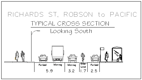
Typical Cross Section
To allow sufficient right turn queuing for vehicles wishing to turn westbound from Richards Street onto both Smithe Street and Robson Street without interfering with the bike lane, two parking spaces will be removed on the western side at each intersection. These parking spaces are currently restricted in the AM and PM peak hours. To improve visibility for cyclists it is also proposed to remove one parking space at the south west corner of Richards Street and Drake Street adjacent to the ambulance station.
The original bike lane design that was shown to the community and stakeholder groups showed a narrowing of the bike lane from 1.7m to 1.2m at several intersections to accommodate right turning vehicles. Based on feedback received from both the community and the Bicycle Advisory Committee (BAC), adjustments were made to the other traffic lanes to provide a continuous 1.7m wide bike lane for the entire length of Richards Street.
The Richards Street bike lane also offers the opportunity to build several corner bulges to improve the pedestrian environment of the street. Potential corner bulge locations have been identified and it is anticipated these bulges will be built as part of future adjacent property redevelopment along the street.
PUBLIC CONSULTATION
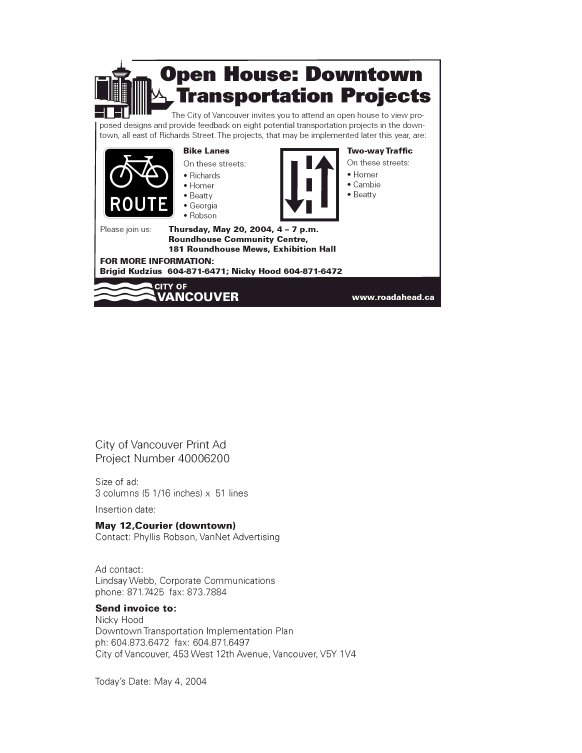
Residents and businesses in the downtown were invited to an open house held at the Roundhouse Community Centre on the evening of Thursday May 20, 2004. Staff from the DTP Implementation Team were in attendance to provide information and answer questions about the Richards Street bike lane and other DTP projects in the easterly end of downtown. Approximately 20 people attended the open house and 100% of the completed surveys indicated support for the Richards Street bike lane. A copy of the Open House advertisement is included in Appendix C and a summary of the additional comments received at the Open House are included in Appendix D.
Various stakeholders were also contacted directly, including the Vancouver Area Cycling Coalition (VACC), the Downtown Vancouver Business Improvement Association (DVBIA), the Yaletown Business Improvement Association (YBIA) and the Yaletown Residents Association. These organisations generally support the bike lane and have no concerns with the design. The BAC support the Richards Street bike lane design which was presented to them on January 19, 2005 (see Appendix E).
FINANCIAL IMPLICATIONS
The estimated cost of the Richards Street bike lane is $34,000 for route signage and pavement markings. $17,000 would be funding from the 2004 Streets Basic Capital Group CB2EA2E (Bicycle Network). The remaining $17,000 will be sought from either TransLink or with the Province's Cycling Infrastructure Program (CIPP) to further reduce the City's share of the cost. There should also be an increase to the 2006 Traffic Operating Budget for Signage of $3,000 for the maintenance of the new signs and pavement markings. Removal of five parking spaces will result in a reduction of parking meter revenue of approximately $15,000 per year, which will be covered by increases elsewhere in the system.
CONCLUSION
The Downtown Transportation Plan seeks to improve downtown accessibility and liveability by creating a balanced transportation system. The Richards Street bike lane is recommended as a component of the downtown network of bike lanes and is supported by the majority of those consulted. The Richards Street bike lane will increase accessibility and mode choice in the downtown.
- - - - -
Link to APPENDIX A - DOWNTOWN VANCOUVER BICYCLE NETWORK
Link to APPENDIX B - TYPICAL PLAN VIEW
APPENDIX C - OPEN HOUSE ADVERTISEMENT
APPENDIX D
PAGE 1 OF 1
APPENDIX D - OPEN HOUSE COMMENTS
Downtown Transportation Plan
May 20th, 2004 Open House Bike Lane Survey
COMMENTS |
Coloured bike lanes should be used in all downtown bike lanes. |
All bike lanes should have white lines on each side, including separation from parked cars. Parked car width allowances should be 2.0m not 2.5m and the extra 0.5m should be marked as a barrier to lessen potential of dooring. |
Right turn lane designs should be up graded with car transition to right lane at least one car length from intersection. |
Bike symbols on bike lanes should not be more than 30 meters apart so that there is always a bike symbol in the sight of a driver - visibility issue. |
1.2m bike lane width should be widened to 1.5m (1.4m) minimum at Smithe. By reducing left lane/parked from 5.7m, small alignment change is insignificant. |
Great ideas! Thank you! |
Even if there were cyclists painted on the edge of roads without lines I think it would help identify to motorists that cyclists use these streets. |
How about cyclists have priority in right hand lane signs where a bike lane is not feasible? |
These lanes help all cyclists. It helps keep traffic in its own lane there by reducing chance of injury to cyclists. Thank you. Keep up the good work. |
It is an excellent idea to have clearly marked bicycle lanes so people will be less likely to use the sidewalks. Good luck. |
Thank you so much for looking at these improvements. It will make downtown cycling much safer. Please continue to invest in cycling improvements on the bridge. |
I support the right turn bays. |
The Homer street profile looks like it can accommodate a bike lane, and would be very useful as a match to Richards and for Library square access. |
It would be good to see stencils and bike markings that don't wear off. Looks good! |
It would be preferable to not have bike lanes next to parked cars. |
Please double stripe'em, colour'em, put stuff in'em so people can't park/drive in'em. |
I prefer two way lanes on the same street rather than couplets. |
I would prefer double markings to keep cars parked off the bike lanes. Knowing coloured paint would be expensive; I think it would draw motorists' attention. My preference is red. Blue seems to fade in a short time. |
I am not fond of the 1.2m bike lanes. When you are between moving vehicles as a not so experienced cyclist, it would feel intimidating. I realize space is the problem and it would force you to take the lane and chase motorists off. Is it feasible to have the parallel street having the 1.5 in the opposite direction? No easy answer, I appreciate. |
Thank-you for all your hard work, looking forward to the implementation of the cycling facilities and believe many will utilize them. |
APPENDIX E
PAGE 1 OF 1
APPENDIX E - BICYCLE ADVISORY COMMITTEE RECOMMENDATION
CITY OF VANCOUVER
| |
MEMORANDUM April 5, 2005
TO: |
Brigid Kudzius, Engineering Services |
FROM: |
Nicole Ludwig, Meeting Coordinator |
SUBJECT: |
Richards Street Bike Lane |
The Vancouver Bicycle Advisory Committee, at its meeting on January 19, 2005, received a presentation from staff on the Richards Street Bike Lane and passed the following resolution:
RESOLVED
THAT the Bicycle Advisory Committee support the revised design for the 800 block of Richards Street bike lane as distributed at the meeting; and
FURTHER THAT the Bicycle Advisory Committee support the entire Richards Street Bike Lane plan.
CARRIED
(Ken Timewell opposed)
Nicole Ludwig
Meeting Coordinator
Phone: 604.871.6399
Fax: 604.873.7419
/nl