|
CITY OF VANCOUVER ADMINISTRATIVE REPORT |

Report Date: |
April 11, 2005 | |
Author: |
Wesley Joe /
| |
Phone No.: |
604.873.7736 /
| |
RTS No.: |
3911 | |
CC File No.: |
5757 | |
Meeting Date: |
April 26, 2005 |
TO: |
Standing Committee on Transportation and Traffic |
FROM: |
The General Manager of Engineering Services, in consultation with the Director of City Plans |
SUBJECT: |
Reclassification of Secondary Arterials to Neighbourhood Collectors |
RECOMMENDATION
A. THAT Council confirm the establishment of the new road category “Neighbourhood Collector” as described in this report.
B. THAT Council approve the re-classification of seven Secondary Arterial roads listed in the report to the category of Neighbourhood Collector.
C. THAT staff report back on a toolkit and priority system for traffic calming on Neighbourhood Collector streets.
D. THAT staff report back on the classification of the streets listed in Appendix B, and in the interim, no changes be made to increase the capacity of these streets.
E. THAT a funding proposal for the treatment of Neighbourhood Collector streets be brought forward for consideration as part of the review process for the 2006-2008 Capital Plan.
GENERAL MANAGER'S COMMENTS
The General Manager of Engineering Services and the Director of City Plans recommend approval of Recommendations A through E.
COUNCIL POLICY
In 1995, Council adopted CityPlan as its vision for the future of Vancouver. CityPlan supports the regional transportation objective of placing a greater emphasis on transit, walking and biking, ahead of cars to slow traffic growth in neighbourhoods and improve the environment.
In 1997, Council approved the Vancouver Transportation Plan, which identified a number of Secondary Arterial streets throughout the city as candidates for reclassification to Neighbourhood Collectors.
Between 1997 and 2004, Council approved six Community Visions. Four Visions include directions which support the reclassification of Secondary Arterials to Neighbourhood Collectors.
PURPOSE
The purpose of this report is to seek Council’s approval to reclassify seven Secondary Arterial streets to the new classification of Neighbourhood Collector, and to outline a plan to address the classification of many other low-volume Secondary Arterials and develop a program for traffic calming on Neighbourhood Collector streets.
BACKGROUND
In 1997, Council approved the Vancouver Transportation Plan. It established the following:
Secondary arterial roads which currently carry relatively low volumes and pass through predominantly residential areas may be reclassified as neighbourhood collectors. Neighbourhood collectors are intended to give local traffic access to the arterial road network and are not intended to carry a greater volume of traffic than they do now, except for trips generated by growth in the local neighbourhood, or to act as arterials. (Action R9)
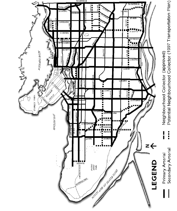
The Plan identified a number of secondary arterial streets to be considered for re-classification (see Appendix A).
Four of the six approved Community Visions contain directions supporting re-classification of Secondary Arterials identified in the Transportation Plan. These four Visions are: Victoria-Fraserview/Killarney, Sunset, Renfrew-Collingwood, and Hastings-Sunrise. Two approved Visions did not include directions regarding re-classification. Kensington/ Cedar Cottage does not contain any Secondary Arterials identified in the Transportation Plan. Dunbar does contain identified Secondary Arterials but the Vision Choices survey was silent on this topic. In addition to the streets identified in the Transportation Plan, the Renfrew-Collingwood Vision supported the reclassification of Slocan Street, from 22nd to Kingsway.
In January 2005, Council passed a motion to reclassify a portion of Victoria Drive as a collector street.
DISCUSSION
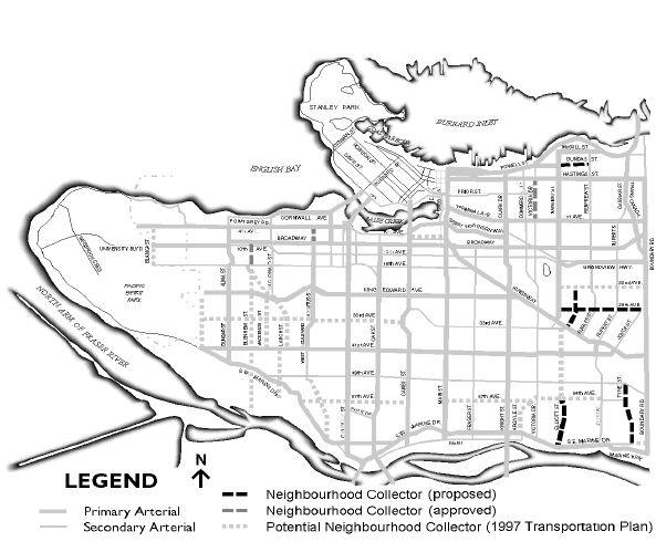
Staff have reviewed low volume Secondary Arterial Streets within the Victoria-Fraserview/Killarney, Sunset, Renfrew-Collingwood, and Hastings-Sunrise neighbourhoods. Based on these streets’ function in the road network and on community support for reclassification, staff recommend reclassifying the following seven streets at this time:
Dundas Street, Nanaimo Street to Renfrew Street
Slocan Street, E 22nd Avenue to Kingsway
East 29th Avenue, Nanaimo Street to Joyce Street
Tyne Street, E 49th Avenue to 54th Avenue
Champlain Street, E 54th Avenue to Matheson Street
Matheson Street, Champlain Street to SE Marine Drive
Elliott Street, E 54th Avenue to SE Marine Drive
These streets recommended for reclassification carry relatively low volumes of traffic and are in predominantly residential areas. They are not integral parts of the arterial street network and are not truck routes. All were supported for reclassification by the residents of their surrounding neighbourhoods in their respective Community Visions surveys.
Neighbourhood Collectors will not be changed to increase their capacity for vehicular traffic (e.g. adding through lanes by stripping parking).Changes may be made to improve safety, and improve conditions for pedestrians, cyclists and, in a few cases, transit users.
The Transportation Plan also established that Collector and Secondary Arterial streets with fewer than 10,000 vehicles per day may be considered for traffic calming which “would be aimed at slowing traffic to 50 km/h, not diverting traffic onto other streets.” All seven streets listed above fall below the 10,000 vehicle per day threshold, based on 1997 traffic volumes. Staff are currently working with residents of Blenheim Street and with CityPlan committees to develop a toolkit for Neighbourhood Collector traffic calming and a protocol for prioritizing candidate streets, and will report back when that work is complete.
Streets identified in the 1997 Transportation Plan but not currently recommended for reclassification are listed in Appendix B, with comments regarding future assessment for reclassification. Many of these streets have not yet been subject to public consultation regarding reclassification. Some which have had public consultation have received ambiguous results. Some require further functional review before staff can formulate recommendations regarding their classification. Several streets identified in 1997 are within the ARKS and RPSC Visioning areas. The Vision surveys in these areas are in process now and staff will report back on the classification of these streets when the results of these surveys are known. Staff will also report back regarding the classification of other streets as public consultation and functional reviews are completed. In the interim, no changes will be made to increase the capacity of these streets.
FINANCIAL IMPLICATIONS
There is no immediate financial consequence to the recommendations of this report. There may be an expectation that future traffic calming will be undertaken on some of these streets. Council will need to review these needs in the context of future capital budgets. A funding proposal for the treatment of Neighbourhood Collector streets will be brought forward for consideration as part of the review process for the 2006-2008 Capital Plan.
CONCLUSION
Staff recommend that Council approve reclassification of seven Secondary Arterials streets listed in this report as Neighbourhood Collectors.