Vancouver City Council |
CITY OF VANCOUVER
POLICY REPORT
DEVELOPMENT AND BUILDING
Date:
December 3, 2004
Author:
I. Smith/K. Hiebert
Phone No.:
873-7846/871-6066
RTS No.:
4635
CC File No.:
8206
Meeting Date:
December 14th 2004
TO:
Vancouver City Council
FROM:
Southeast False Creek Steering Committee
SUBJECT:
Southeast False Creek Official Development Plan
RECOMMENDATION
A. THAT Council refer the proposed South East False Creek Official Development Plan (ODP) to public hearing; and
FURTHER THAT the Director of Legal Services be instructed to prepare the necessary ODP By-Law for public hearing along with any ancillary by-laws the Director of Legal Services considers necessary;
B. THAT Council acknowledge the contributions of the Southeast False Creek Stewardship Group in the preparation of the Official Development Plan (ODP) and that staff report back on the continued participation of community advisory groups through the sub-area rezonings and development of the new community.
City Manager's Comment
The purpose of this report is to refer the revised Southeast False Creek Official Development Plan to public hearing in the New Year. Since Council instructed staff in July to revise the plan, a new form of development reflecting a low to medium rise option, including reconfigured street and park systems, has been developed. The public benefit package has also been revised with enhanced affordability, additional childcare and a larger community centre.
In July, Council also directed that the value of the City's lands in South East False Creek be reinvested in the project to achieve the reconfigured plan and revised public benefit package, but that the cost of servicing and developing the City's lands be recovered from the revenues generated from the City's lands. Consequently, a financial analysis of the reconfigured plan is required.
The financial analysis will be comprehensive and incorporate all costs including revised estimates for shoreline stabilization, soil remediation, servicing, and the costs of implementing the new public benefit package. The analysis will also address the allocation of costs between the City-owned lands and the private lands to be covered by the proposed SEFC ODP, and the City as a whole. The financial analysis of the costs of implementing the reconfigured plan will be completed by year end and will be made available to Council and the public in mid-January for consideration at the public hearing. This will ensure that Council has all the information it needs to make a balanced decision.
The City Manager RECOMMENDS approval of A and B noting that Council will be provided with full financial analysis prior to the Public Hearing.
COUNCIL POLICY
· In October 1999, Council approved the Policy Statement for Southeast False Creek to guide future planning of the site.
· In July 2004, Council approved amendments to the Southeast False Creek Policy Statement (contained in Appendix A) and established the Southeast False Creek Steering Committee to oversee the project.PURPOSE
The purpose of this report is to refer the Southeast False Creek Official Development Plan (SEFC OPD) to public hearing.BACKGROUND
Site Description
SEFC is located on the False Creek waterfront between Cambie Bridge and Main Street, north of 2nd Avenue. The site comprises a total of approximately 32 hectares (80 acres) of land currently zoned M-2 and FC-1. The City of Vancouver owns most of the land north of 1st Avenue and a number of sites between Quebec Street and Main Street. Translink owns a site north of 1st Avenue at the corner of Quebec Street. The remainder between Quebec Street and Main Street, and between 1st and 2nd Avenue is privately owned.
Recent Planning Process
In July 2004, at a public meeting, following comments and concerns raised by the public and advisory groups, Council made a series of choices establishing new directions for the SEFC ODP (see: Appendix B). The primary choices were a different financial approach allowing the current value of the land to be reinvested in the site and to pursue low- and mid-rise forms of development. The intent is that the revenues generated cover all development costs e.g. servicing, remediation, infrastructure costs, etc, but do not necessarily recover the land value or earn a profit for the City's Property Endowment Fund. This new approach and Council's direction permitted the development of a significantly different Official Development Plan, having particular regard to the heights, form, waterfront design and location of heritage buildings. At the same time the size of the community centre, the level of childcare, and housing affordability have been increased.
Figure 1
DISCUSSION
Vision for the SEFC Neighbourhood
The Official Development Plan (ODP) for Southeast False Creek provides a framework within which the environmental, social and economic sustainability objectives, intent, and policies contained in the Southeast False Creek Policy Statement are carried forward and realized in the design of the community.
South East False Creek is envisioned as a predominantly high density residential neighbourhood in which a mix of other uses will result in a community where people live, work, play and learn; a neighbourhood that has been designed to maintain and balance social equity, livability, ecological health, and economic prosperity, so as to support choices to live in a sustainable manner.
It is a community which is intended to move significantly towards sustainable development and in doing so, provide a learning experience which can be applied at a much broader scale. It has been contemplated as a complete community with goods and services within walking distance, and will offer housing linked by transit to nearby jobs.
To do this the SEFC ODP uses and builds on the knowledge gained from the major waterfront redevelopments in Vancouver. In addition to a complete community near jobs in the central area and which focuses on pedestrians and bicycles first and is linked to transit, SEFC will be unique in its commitment to reduce energy consumption and greenhouse gas emissions, reduce water use and waste, promote urban agriculture and green building practices, and move significantly toward social sustainability in an environment of acceptance, inclusiveness, health, safety and education.
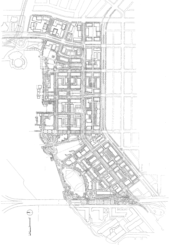
The Plan
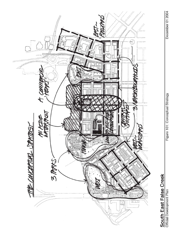
The Illustrative Plan in the ODP (see: Appendix A) has been developed on principles which embody comments from the public and Council's direction. Design principles and highlights of the plan include:
A. Neighbourhoods and Parks
Parks and public open space organize the community into three distinct neighbourhoods. The neighbourhoods derive their form and development footprint from the historic patterns of the site and adjacent communities. Three waterfront parks, a west, central, and east park space, are featured. In addition, small `pocket' parks have been created in three locations along 1st Avenue to provide residents with easy access to park space throughout SEFC.
While Council gave staff the ability to consider up to a 10% reduction in the 26.4 acres of park previously mandated on the public lands, the new Illustrative Plan includes 25.4 acres on the public lands (a 4% reduction) and an additional .45 acres on the Translink Lands for a total of 25.85 acres, totally a 2% reduction.
B. Low- to Mid-Rise Form
The new plan features a low- to mid-rise concept for height that is sensitive to the context and reinforces the natural form of the False Creek basin. The new plan integrates the private lands carefully into the concept, with generally lower heights on the public lands stepping up to 12 storeys (38 metres or 124 feet) on the private lands between 1st and 2nd Avenue. Slightly higher buildings are also being finalized in four locations on the private lands to frame open space and terminate views. A new vision south of City Gate would see heights quickly stepping down from a tower near Terminal Avenue and generally match the Van City building in height.
In developing a low- to mid-rise form the development footprint and street and pathway pattern has also changed. A finer grain, more pedestrian friendly urban structure has been developed north-south connecting the private and public lands, and east-west by adding mews and shifting the northernmost street closer to the water. In addition to the Salt Building, two other buildings with heritage merit (the `Sawtooth' and Wilkinson Building) are proposed to be retained in their current locations adding interesting variations to the plan.
C. Commercial Centre
The community will focus on a local commercial shopping area centred on Manitoba Street which includes the reuse of the Domtar Salt Building, in its current location, adjacent to the community square. Manitoba Street will extend around the Salt Building in a configuration to be determined at the sub-area zoning stage, and will be pedestrian-oriented. Local serving retail shops will be required at the ground level along both sides of Manitoba Street, including provision for a medium size grocery store and farmer's market, to provide for the shopping needs of the whole community. The community square north of the Salt Building is approximately .2 hectares (.5 acres) and will provide an area for community activities and open air retail.
D. WaterfrontThe introduction of a new street (Front Street) close to the water provides an opportunity for retail, restaurants, and community use to contribute to an active and exciting waterfront.
The public waterfront will be engaged with new development and animated through the selection of land uses and design of shoreline features, such as wharfs, boardwalks, and pedestrian bridges that recall the site's historical pattern of boat `slip-ways'.The community heart will be connected to a cluster of community services via Front Street and the Waterfront walkway/bikeway. A full-size community centre (30,000 sq. ft or 2,787 sq. m) to serve SEFC including a non-motorized recreational boating facility will be located in the vicinity of the waterfront area north of Front Street, with easy access to docks for launching boats. The elementary (K-7) school, along with a daycare and an after-school care facility, will be located within walking distance of the community centre/boating facility. The waterfront park between the community centre and school is proposed as a community `learning' garden to provide garden plots and sustainability lessons for children and adults.
Further investigation of shoreline stabilization issues and costs have resulted in an amended Illustrative Plan that suggests the opportunity for temporary structures, but no permanent habitable structures, within a 30 metre (98 foot) setback from the top of the bank of the shoreline. Staff will report back on a recommended strategy for the shoreline geotechnical (seismic) design as part of the Financial Analysis Report in January 2005.
E. An Integrated Sustainable Transportation Approach
The plan proposes a street system that minimizes the widths of right-of-ways, creates a finer pattern of development, and sets a hierarchy of pedestrian, bicycles and transit before the automobile. Standard residential street rights-of-ways have generally been reduced from 66 feet (20 metres) to 59 feet (18 metres), a 10% reduction, to increase the size of the park and development parcels.
The Illustrative Plan has been informed by a sustainable transportation study that anticipates that 60% of trips in future SEFC will be non-auto, and consequently includes many pedestrian routes into and throughout the park and development areas, from pathways to pedestrian-oriented mews, to sidewalks on tree lined streets.
Cycling is expected to be an important form of transportation for residents and workers in SEFC. Two important east-west bike routes are along the waterfront (the Seawall Walkway/Bikeway) and along 1st Avenue. The extension of the Ontario Street Greenway connects to Mt. Pleasant. On the east, the Central Valley Greenway connects SEFC to East Vancouver, Burnaby, and New Westminster.
In the central portion of the site, walkers and cyclists can choose a slower path on the water's edge that will accommodate many different types of users and activities and be more recreational in nature, or a faster moving waterfront by-pass on the north side of Front Street from Ontario to Columbia.
The right-of-way for 1st Avenue has been reduced by 10% from 88.5 feet (27 metres) in the previous plan to effectively 80 feet or 24.5 metres (including setbacks). 1st Avenue still provides a dedicated right-of-way for the proposed Downtown Streetcar, bike lanes in both directions, a parking lane and two moving lanes. In addition, provisions will be made for accommodating a bus route along 2nd Avenue, transit priority improvements along Main Street, and docks for the False Creek ferry operators along the SEFC waterfront.
The internal street network of SEFC is conceived as local-serving residential streets. Wherever possible, nearby arterials will accommodate vehicular traffic generated to/from SEFC. Sustainable landscaping and stormwater management will be showcased where possible and these design intentions will be expanded later as part of the SEFC Design Guidelines.
F. Housing Affordability
Instead of the 20% non-market and 80% market mix that had been previously contemplated, the new plan now contemplates 1/3 low income, 1/3 middle income, and 1/3 high income for the City Lands. In accordance with existing policy, the 1/3 low income will be distributed and integrated across the City owned lands. For the middle income (affordable housing component) a similar strategy will be employed in the detailed zoning stage. At that time, staff will report back on various options that would include market rental housing, market condominiums with restrictions to ensure long term affordability, or the integration of mixed market projects. Other options could include co-housing with affordability requirements or affordable live/work. The higher income component will also be determined at the time of detailed zoning, but it is generally thought that higher amenity sites next to parks and waterfront will be set aside for these units.
G. Sustainability
A comprehensive approach to sustainability across the site has been incorporated in the new plan. In addition to a complete community design and progressive sustainable transportation approaches, this plan is unique in its approach to re-using heritage buildings, urban agriculture, stormwater management, affordable housing and public amenities to support the social health of the community.
A Green Building Strategy for SEFC, as adopted by Council in July 2004 (see: Appendix C), will also be applied to the SEFC lands with a LEED gold standard for City owned buildings and demonstration of at least LEED silver on the private sites (although per Council policy registration is voluntary at this time), as well as some baseline mandatory environmental criteria for all development sites to reduce energy, greenhouse gas emissions, water use and waste, and promote urban agriculture. Social sustainability criteria in terms of meeting basic needs (e.g. affordable housing), maintaining and enhancing human capacity (e.g. local employment) and maintaining and enhancing social capacity (e.g. places for social interaction) have also informed the plan.
Draft indicators and targets in each of the spheres of sustainability are being developed and will be reported to Council before the Public Hearing. It is important to note that the targets are subject to updating as the project gets built out and as needs and technology permit even more ambitious objectives.
In addition, demonstration projects will be further investigated for implementation on the city-owned lands, as resources are identified for these projects. These demonstration projects will be confirmed at sub-area zoning stages or as funding partners are identified and could include:
· Environmental demonstration projects (greywater recycling, rainwater use indoors, composting toilets, blackwater treatment, and commercial greenhouses in public buildings);
· Olympic Village energy system and expansion capacity to larger energy precinct with the False Creek Flats and False Creek North (geothermal energy supply system, district heating system, sewer line heat recovery and fuel cell applications for emergency back-up systems);
· Special high quality design and artistic demonstration of stormwater management facility;
· On-site hydrogen production for fuel cell applications that minimises green house gas-based energy as an input;
· Solar/photovoltaic demonstration projects.Plan Statistics
The SEFC ODP By-law will regulate both the public and privately owned land. The total community will include approximately 587,576 sq. m. (6,324,822 sq. ft.) of development of which approximately 519,081 (5,587,524 sq. ft.) will be residential. These are gross density figures, and do not include exclusions. Of the units contemplated on the public lands, 1/3 will be low income (social/non-market housing), 1/3 middle income (affordable market), and 1/3 higher income (market). On the public lands, 35% of the units will be designed to be suitable for families with children. On the private lands, 25% of the units will be designed as suitable for families. At CD-1 zoning, staff will further investigate how best to achieve a compatible housing strategy on the Translink site and privately-owned lands.
In regard to the City-owned lands, the plan has achieved 203,773 sq. m (2,193,386 sq. ft) of residential uses, and 22,725 sq. m (244,608 sq. ft) of combined commercial and flex uses.A full provision of public amenities will also be supported in the ODP, including parks totalling 10.4 hectares (25.8 acres); a community/boating centre; childcare centres, out of school childcare spaces and family childcare spaces; and a site for a K-7 school.
The Private Lands
The plan for SEFC integrates the adjacent private lands through the street network, ground plane design, and building heights. While the general height maximum for the lands between 1st and 2nd Avenues is lower than previously contemplated, the maximum density allowance of 3.5 FSR that had been discussed with the landowners under previous plan scenarios has been maintained.
In the case of sites eligible for heritage and cultural density bonusing, staff will continue to work with landowners through CD-1 zoning to achieve additional density on specific sites, while maintaining coherence with the overall plan. For sites with heritage value, for example the Opsal Steel site, permitting density to be transferred out of the SEFC area (e.g. amending the Transfer of Density policy) along with other incentives such as tax relief, Development Cost Levy (DCL) relief, and granting opportunities through the Federal Government's "Historic Place Initiative" program, will be examined. The goal will be to craft an incentive strategy for each of these sites, using a variety of methods, while maintaining the viability of the City's program for banking heritage density as well as other City objectives.
In the case of the site currently planning to accommodate the existing Playhouse Theatre Production Centre, additional funding mechanisms for cultural amenities (senior government funding, private sector fund raising, capital plan, CACs etc.) will be explored during the CD-1 stage of planning.
An approach to development form has been established in the plan for the sites south of City Gate between Quebec and Main Street. However, staff note that the final density and heights will be resolved (applying the amenity bonusing policies of the City for development beyond the baseline plan) at sub-area CD-1 zoning stage as part of the negotiation around amenities and as further clarity regarding adjacent land uses and development form is achieved through the False Creek Flats planning process.
CONSULTATION PROCESS
The revised Official Development Plan and Illustrative Plan with supporting material and model were presented to Council's advisory groups, the adjacent communities and to the public generally. They were strongly supported, as outlined below.
A. SEFC Stewardship Group: The Stewardship group expressed strong support for the revised plan and ODP By-law. They noted that many changes, including more affordable housing, a full-sized community facility, increased childcare and a more active waterfront, were strongly advocated by the group when reviewing the previous plan. Their comments are provided in Appendix D and will be supplemented by more detailed comments that will be forwarded to Council prior to public hearing.
B. Heritage Commission: The Heritage Commission supported the revised plan with regard to the retention of the three identified heritage structures on the City's lands and the decision to leave them in or very near their current locations. Suggestions for additional improvement related to: further consideration of bringing water to the Salt building; leaving the Wilkinson Building in its existing location, and considering ways to re-configure the shoreline to recall the `slipways' of the past.
Staff have reviewed these suggestions and undertaken further study of the plan's ability to respond to them. A plan is currently being investigated which would leave the Wilkinson Building in its current location and have the road pass through the building structure. Additional technical work will be undertaken to review the feasibility of this proposal. Work is also being done on park design to recall the historic `slipways'. With respect to water near the Salt Building, the next phase of planning will look at opportunities to use stormwater in close proximity to the building.
C. The Urban Design Panel: The Urban Design Panel gave unanimous support to the revised Illustrative Plan, noting significant improvement to the height and massing, the integration of public and private lands, the redistribution of park spaces, and the active waterfront. It was felt that further design development was required to improve sunlight access into courtyard spaces and into the central "hinge" park.
D. Disabled and Seniors Committee: Strong and unanimous support was given for the revised Illustrative Plan. The inclusion of universal design as a requirement in the ODP to provide high levels of accessibility was also strongly supported and seen as a major step forward in planning for the disabled community. Investigation of accessibility and application to building design, public realm and open spaces will be conducted in consultation with the Advisory Committee on Disability Issues including implications on cost of development at the CD-1 stage of planning.
E. Vancouver City Planning Commission (VCPC): The Vancouver City Planning Commission strongly supported the new plan, noting in particular the improvements made by creating a more active waterfront area, the improvement to the height and massing of the proposal, and the improved public amenity package.
F. The Bicycle Advisory Committee (BAC): The BAC has given support to the plan, notably the changes that have been made to the ODP through an iterative process between staff, the design team, and the BAC members.
As a result, significant bicycle improvements were made to the plan including: provision of 1.5m bike lanes on 1st Avenue, wider bike facilities and a minimizing of potential conflicts along the waterfront route, accommodation of bike lanes or pathways on Ontario Street, separated from pedestrians. The BAC supports the ODP going forward with these revisions but has noted their continued interest in commuter bike facilities on Quebec and no drop off for the school.
Staff note that the current plan is a balance between all modes of transportation. The school drop-off will be looked at in detailed design, and while it is unlikely that the drop-off will be removed, its complete separation from the bike path can be achieved. With regard to Quebec Street, bike lanes are not possible due to the future development of the streetcar and the limitation imposed by existing SkyTrain columns. As a result staff are looking at bicycle improvements in Creekside Park.
G. Public Information Meetings: Two major events were held, one in the concourse of the Vancouver Public Library and one in Mt. Pleasant at the Ukrainian Auditorium. Both were very well attended, each drawing 200 - 250 people. The support for the plan was very strong, particularly for the low to mid-rise form, heights, sustainability measures including the transportation approach, and the active waterfront. The increase in affordable housing was also strongly endorsed. Ninety-four survey forms were filled out with a 73-80% support rate for the plan on all questions posed. Complete results of the survey are included as Appendix E.
FINANCIAL IMPLICATIONS
On July 20, Council instructed staff to amend the ODP and thereby broaden the public amenity package as follows:
_ Change the mix of housing on the City Lands to 1/3 low income, 1/3 middle income, and 1/3 high income;
_ Reduce the form of the development to mid-rise;
_ Develop a more attractive waterfront;
_ Increase the proposed community centre from 10,000 sq. ft. to 30,000 sq. ft. and accommodate a non-motorized boating facility;
_ Change the distribution of the park space to reflect a better balance over the site;
_ Narrow the street rights of way;
_ Leave the heritage buildings in place rather than move them;
_ Increase the childcare to normal development levels.Council was advised that these changes would have an impact on the financial assumptions that underlie the ODP with additional costs anticipated to be in the range of $47.5 million plus the still-to-be-determined foreshore stabilization and soil remediation costs associated with the revised form of development.
In response, Council instructed staff to invest the return expected on the value of the land owned by the City in SEFC - estimated at $50 million - in the project to assist in achieving the overall public amenity package.
Since July 26, the Illustrative Plan has been revised and work is underway to provide updated estimates of the impacts of the revised plan on development economics for the City-owned lands, and on the costs of preparing the site for development (including significant foreshore and soils requirements) and of providing the revised public amenity package. A full report on the financial issues arising from the revised ODP will be presented to Council in advance of the public hearing.
In revising the financial implications of the redevelopment project, staff have proceeded on the basis that Council's intention is to increase the contribution from the PEF such that its involvement results in a financial break-even position. That is, to the extent the outcome of this project can be accurately projected over 15 years, the project revenues would cover the costs of servicing and preparing the site for development and the Property Endowment Fund will invest the return it would have expected on the land into the public amenity package. This assumption is being built into the financial analysis.
Despite this additional investment, the cost of the public amenity package identified by the community and Council is significantly higher than the contribution expected from the PEF alone. However, the ODP financial plan continues to assume that the private lands would also contribute to the public amenity package anticipated for SEFC. Participation from private land owners within the ODP area would be achieved through the application of Development Cost Levies and Community Amenity Contributions on their developments that would be directed to the public amenity package. Moreover, to the extent that the development offers a wider public benefit, the City could use its more traditional funding sources, including the Capital Plan, City-wide Development Cost Levies (DCLs) and Community Amenity Contributions (CACs), senior government funding and partnerships. Staff are working on a financial strategy that will outline how the revised public amenity package can be achieved or adjusted in response to changing circumstances. This approach will be reported fully in the Financial Report.
ADDITIONAL ACTIONS AND CONSULTANCIES
In July Council also recommended further study in a number of areas.
A. A Public Investment Model. Reinvesting the value of the City's lands into the site is an investment in the community particularly in both social and environmental sustainability. To better reflect the benefits of this reinvestment, Council requested the preparation of an advanced financial model that would recognize additional social and environmental benefits where possible. Work is well underway on this model, which is being done in the format of Multiple Accounts Evaluation. It is the intention of staff to inform Council of the results before the public hearing. It is important to note that this analysis will bring forward another set of measures by which to evaluate the SEFC plan, however it does not easily fold into a cash-flow analysis to achieve Council's objective of `break-even' development on revenues and costs.
B. Targets and Indicators. In reconfirming its commitment to sustainability, Council asked that targets and indicators be developed as a means to measure success. As the indicators and the development of the advanced public investment model are linked, the two tasks have been combined. The consultancy will produce the initial targets and indicators recommended for the ODP on or before the Public Hearing.
C. Interfaith Spiritual Centre. In accordance with Council's recommendations the ODP by-law has been amended to include this use. The exact location(s) will be determined when discussions with the International Olympic Committee are concluded. The proponents behind the Interfaith Spiritual Centre intend to purchase or lease land from the City or Private landowners at market value.
D. Report on Bioremediation. On the instruction of Council a soils consultant is finalizing an assessment as to the applicability of bioremediation on the Southeast False Creek site. This assessment which looks at contamination, phasing, and bioremediation techniques, concluded that this approach had limited application on the SEFC site. The report will be forwarded to Council before the public hearing.
SEFC STEWARDSHIP
Staff note that moving toward sustainability requires community will, understanding and involvement. The SEFC Stewardship Group has played an important role in keeping watch over the SEFC ODP plan and process. Staff support the Stewardship Group's recommendation to continue their work through the CD-1 zoning stages, with the view that it evolves, over time, into a neighbourhood association, as recommended in the SEFC Policy Statement.
CONCLUSION
All of the July Council directions have been incorporated into the Official Development Plan and accompanying Illustrative Plan. The revised plan has been strongly supported by the public, all advisory groups and the Southeast False Creek Stewardship Group. Some potential additional costs have been identified that are dependent on strategies for Council's consideration for shoreline stabilization and soil remediation which will be detailed to Council in a forthcoming Financial Analysis report. The importance of securing a project contingency, without compromising key project goals, will also be discussed.
- - - - -
Appendix A SEFC ODP Illustrative Plan
Conceptual Plan
Appendix B
SPECIAL COUNCIL MEETING
(Choices and Directions for the Planning of Southeast False Creek)DECISIONS
DATE:
Monday, July 26, 2004
TIME:
2:00 p.m.
PLACE:
Council Chamber
Third Floor, City HallFor information, please call Tina Hildebrandt, Meeting Coordinator, at 604.873.7268
E-mail: tina_hildebrandt@city.vancouver.bc.ca1. Choices and Directions for the Planning of Southeast False Creek
A. THAT Council approve a Steering Committee for the redevelopment of Southeast False Creek co-chaired by the City Manager and Councillor Raymond Louie and also include Councillor Peter Ladner on the Steering Committee.
B. THAT the City Manager appoint relevant staff to the Southeast False Creek Steering Committee.
C. THAT the publicly-owned lands on Southeast False Creek generate a return to the Property Endowment Fund sufficient to recover the costs of servicing and preparing the site for development (estimated at $56 million in the current Official Development Plan submission);
THAT the contribution from the Property Endowment Fund as owner of Southeast False Creek lands to neighbourhood specific public amenities in Southeast False Creek be limited to the net development revenue generated by the value of the land (estimated at $50 million) plus the normal developer's risk margin/profit (estimated to be $12 million based on the current Official Development Plan submission); and
THAT the costs of broader City-wide public amenities that may be developed in Southeast False Creek be funded from traditional capital funding sources including City-wide Development Cost Levies and Community Amenity Contributions and the capital planning process or from non-City funding.
D. THAT Council confirm the following choices included in Section B of the Workbook (attached as Appendix A to the Policy Report dated July 14, 2004, entitled "Choices and Directions for the Planning of Southeast False Creek") as amendments of the Southeast False Creek Policy Statement:
THAT Council establish a target of 1/3 (non-market)/ 1/3 (affordable)/ 1/3 (market) housing policy for the SEFC City-owned Lands;
THAT SEFC provide a full-size community centre serving all of SEFC, including a community boating facility for non-motorized recreational boating;
THAT only Low and Mid-Rise buildings be permitted, west of Quebec Street, with the intent to realize the target density;
THAT, while 26.4 acres of park is preferred, slightly less park space (10% less park - 2.64 acres) may be considered in order to meet other priority objectives;
THAT the intent is not to widen 1st Avenue but to include building lines on City Lands to widen if necessary in the future after staff report back on the comprehensive transportation plan for SEFC including the Downtown Streetcar;
THAT a more active water's edge as a lively destination be pursued - encroaching into 30 m setback if necessary (phase so as to minimize encumbrance with False Creek sediment contamination management);
THAT instead of almost all residential, consider the opportunity for more than 200,000 sq. ft. of commercial development and jobs - especially of compatible activity such as eco-businesses, artistic businesses, net portal offices, and live-work; and
THAT the Salt Building and one or both of the other heritage buildings be kept generally in-situ (do not move them).
E. THAT Council approve the following new policies for the Southeast False Creek Policy Statement included in Section C of the Workbook (attached as Appendix A to the Policy Report dated July 14, 2004, entitled "Choices and Directions for the Planning of Southeast False Creek"):
THAT the SEFC ODP include specific sustainability goals, targets and indicators and require tracking/monitoring of performance with regular report out - for example, energy consumption and material consumption per capita - and commit necessary funding to do this; cross referenced with GVRD sustainability model;
THAT the SEFC ODP explicitly express the intent for architectural excellence and to bring significance to community buildings as `signature' designs; and ensure a distinctive design image for the whole community;
THAT a Neighbourhood Transportation Demand Management program be included as an integral part of the SEFC ODP implementation, including on-going monitoring as build out of SEFC occurs;
THAT a neighbourhood energy demand management program be included as an integral part of SEFC ODP implementation; and
THAT, as SEFC develops, the area should be used as a "learning lab", created with local universities and other interested parties. In this capacity, SEFC should act as a focus for research and development to implement and evaluate general principles of sustainable design with the intention of fostering understanding of ecological stewardship amongst professionals, academics, the development community, and the general public.
F. THAT Council confirm the following existing policies in the Southeast False Creek Policy Statement included in Section D of the Workbook (attached as Appendix A to the Policy Report dated July 14, 2004, entitled "Choices and Directions for the Planning of Southeast False Creek") as priorities:
THAT Council confirm as a priority, the policy requiring environmental sustainability (and LEED) that provides a new level of "base case" sustainability performance that can be applied to other projects in the City and implement demonstration projects to showcase especially innovative environmental measures (take risks to experiment) - such as using alternative energy and maximizing green roofs;
THAT Council confirm as a priority the policy requiring significant urban agriculture;
THAT Council confirm that the SEFC ODP boundaries will include City and adjacent private lands - and that this be reflected in an integrated Illustrative Plan and phasing policies;
THAT Council confirm that the SEFC development on City-owned lands be structured with a variety of parcel sizes so as to foster an incremental quality to the pattern of that development; and
THAT Council confirm as a priority the policy of universal design to provide high levels of accessibility, acknowledging that there are some exceptions that may be necessary related to rowhouse or multi-storey residential units; and include provisions for aging in place, including accessibility, mobility, and safety in the SEFC ODP.
G. THAT a consultant be retained to develop an advanced public investment model that considers the economic, social and environmental benefits of developing a model sustainable community in Southeast False Creek (e.g. "full cost accounting", "triple bottom line accounting", and/or "multiple accounts evaluation") using a gender-responsive lens.
H. THAT staff and a consultant review and recommend the most progressive approaches to soil remediation for Southeast False Creek lands.
I. THAT staff report back on the implications of leasehold vs. freehold on the City lands of Southeast False Creek.
J. THAT staff develop zoning for the private lands of Southeast False Creek that includes a level of outright density allowance and a higher discretionary level of density allowance with the discretion used to meet public objectives.
K. THAT the City develop in conjunction with the Vancouver Organizing Committee for the 2010 Olympic and Paralympic Winter Games (VANOC) a security strategy for the Olympic Athlete's Village in Southeast False Creek in regard to development and review it with local stakeholders (for example, setbacks and development phasing).
L. THAT the Southeast False Creek Official Development Plan and its Illustrative Plan be further developed with the following instructions: show strong preference for pedestrians, bicycles and transit over cars; reallocate park to provide a better balance between the east and west including smaller parks in the east neighbourhood providing that they do not dissipate usable park space; provide direct linkage of the Ontario greenway/bikeway into the park system; develop roofs as green spaces and for recreation with some consideration of linkages; and investigate approaches to bring water in closer association to the in-situ Salt building.
M. THAT Council approve the work program for development of the Southeast False Creek Official Development Plan and sub-area rezoning of the Olympic Athlete's Village, as well as staffing and budget, as set out in the Policy report dated July 14, 2004, entitled "Choices and Directions for the Planning of Southeast False Creek", at a total cost of $155,250 with the source of funds to be the Property Endowment Fund.
N. THAT staff report back on the requirement for additional funding for consultants arising from the resolutions above.
O. THAT staff report back when bringing forward the Southeast False Creek Official Development Plan and Illustrative Plan on benefits, costs and revenues for the City of this initiative.
P. THAT in completing the ODP and Illustrative Plan for SEFC, staff consider possibilities to narrow the exclusively residential streets to provide greater area for development or park.
Q. THAT the ODP be amended to make provision for the preservation, maintenance, and incorporation into the site of found artifacts and any discovered heritage fabric.
R. THAT staff report back in the context of the ODP on the option of an Inter-spiritual centre and shared house of worship, including business parameters, locational preferences, and zoning requirements.
S. THAT as part of the preparation of the ODP for SEFC, staff review the childcare requirements with the intent of achieving the major project standard if possible.
T. THAT Council acknowledge the on-going collaborative relationship between the City and the owners of the private lands, generally between 1st and 2nd Avenues and Main and Wylie Streets, and instruct staff to give priority to the development of a complimentary zoning, upon completion of the Southeast False Creek Official Development Plan, for these lands to be brought forward at the earliest opportunity after adoption of the zoning for the Olympic Athlete's Village.
- - - - -
Appendix C: Green Building Strategy & Proposed Implementation
SEFC Green Building StrategyA green building strategy for SEFC must achieve a minimum baseline of environmental performance in all facets of building design and construction. This strategy applies to all medium and high density residential (over 4 stories), mixed-use, commercial, institutional, and industrial developments in SEFC. This strategy is founded on the principles of the LEEDTM green building assessment program, which provides a robust tool to guide development of a variety of green building types. Developed as a 69 point system with a variety of "levels" of green achievement, the system is flexible enough to allow residential and mixed-use buildings to gain significant points in the LEEDTM system. Additionally, the local design and engineering community has embraced LEEDTM as the preferred building performance tool.
The "requirement" of LEEDTM certification as a mandatory standard for development is problematic. Being that the LEEDTM rating is determined after construction and after occupancy, it is impossible to ascertain with confidence the exact level of final certification. As such, it is advised that a green building strategy for the City of Vancouver should use LEEDTM as a design tool to shape development and set performance standards, creating a baseline for development in South East False Creek. Registration and completion of the program should not be mandatory at this time. In combination with the use of LEEDTM as a design tool, certain technologies and/or points under the system will be required by the City to ensure that each project meets the specific goals of the SEFC Environmental Reports and the Cool Vancouver Recommendations. These required elements will not be onerous, and will help the developer to achieve some of the LEEDTM identified objectives. All LEEDTM points would be available to the developer, with a minimum 34 points plus all LEEDTM prerequisites and City specific requirements as the baseline for developments using this strategy. The building must be designed and perform according to a minimum LEEDTM Silver standard.
The developer will make their own choice as to if they choose to undertake the full registration and certification process with LEED BC and the Canadian Green Building Council. If a project is formally registered through the CAGBC/LEEDTM BC to achieve a minimum LEEDTM Silver level, and registration is submitted with the development permit application and approved as condition of the development permit, then Part 2 (the LEEDTM-based portion) of the City's green building strategy can be waived. Part 1, mandatory requirements, must still be met by every project. All projects not formally registering with the CAGBC will follow the proposed green building strategy, with firm commitment taken through the development application and resultant development permit (A LEEDTM Accredited Professional must be on the design team). Given South East False Creek's mandate to be a model sustainable community, it is apparent that this may be a key opportunity to first use LEEDTM strategies to shape green building design in Vancouver.
The strategy below outlines those points in each LEEDTM category that are most easily attainable with little cost for a multi-unit residential, mixed-use, commercial, or institutional building. This strategy assumes that all prerequisites can be met and an Integrated Design Process (IDP) with a LEEDTM Accredited professional on board is undertaken from the outset. Points identified in this strategy were chosen through an evaluation of all LEEDTM multi-unit residential and mixed-use developments currently accredited and/or registered with the USGBC and CAGBC. Those points that were gained in nearly all projects were taken to be very viable. Those points attained by most projects were assessed against the development environment in SEFC (SEFC). Finally, "sustainable sites" points were determined solely on the basis of SEFC and its context.
PART 1: MANDATORY BASE LINE STRATEGY REQUIREMENTS
Energy:
Minimum energy efficiency to meet ASHRAE 90.1 2001 (this prerequisite will be defined through further consultation with stakeholders).
Specify energy efficient appliances -- EnergyStar rated appliance and/or gas appliances, except for laundry dryer.
Energy efficient lighting to follow ASHRAE 90.1 2001 including user metering, smart controls, and occupancy sensors for public spaces.Specify fireplaces listed as a heating appliance with a minimum combustion efficiency to meet or exceed ASHRAE/IESNA Standard 90.1 - 2001 heating appliance standards. No continuous pilot lights; interrupted power ignition is preferred. Electric fireplaces must be 100 percent efficient and offer heat/no heat modes.
Heating of domestic hot water to be done with high efficient boilers with a minimum efficiency of 87%; possible supplement by solar hot water.
Parking:
Maximum parking standard is less than the vehicle ownership of communities adjacent to SEFC for comparably sized dwelling units and scaled generally in response to the size of the dwelling unit, but even for the smallest units one parking stall per unit is permitted.
The Minimum Permitted Parking shall be .5 spaces per dwelling unit for dwelling units under 50 m2 GFA, 1 space per dwelling unit for dwelling units greater than 82.5 m2 GFA and scaled to .5 spaces plus 1 space per 165 m2 GFA for dwelling units between 50 to 82.5m2 GFA.
The Maximum Permitted Parking shall be 1 space per dwelling unit for dwelling units under 50 m2 GFA, 2 spaces per dwelling unit for dwelling units greater than 189 m2 GFA and scaled to .65 space plus 1 space per 140 m2 GFA for dwelling units between 50 to 189 m2 GFA.
Designated visitor parking shall be separately required at a rate of 0.1 spaces per residential dwelling unit, and provided either on-site or at a centralized parking facility nearby.
Ensure that a car-sharing [or co-op] vehicle, accompanied by a designated parking space, be provided for sites with 50 to 149 dwelling units, and a second car-sharing vehicle and space for sites with 150 or more dwelling units.For future car-sharing, one additional designated parking space, be provided per 100 dwelling units (but no less than one per site).
Specify that a minimum of 10% of parking spaces are designed as garages to accommodate conversion for a storage function (current outstanding City bylaw issue).
The provision of less than the minimum parking subject to approval by the General Manager of Engineering Services and Director of Planning of a site specific Transportation Demand Management (TDM) plan that restricts residents' car ownership and supports other means of mobility.
Water:
Dual flush toilets.
Low flow faucets and showerheads to exceed current best practices (preference given to fixtures meeting 1.5 gpm flow rates and 6/3 dual flush toilets).High efficiency irrigation system (drip irrigation), stormwater reuse for landscape irrigation, or no permanent irrigation.
Waste Management:
Composting for on-site gardens and/or landscaping.
3 streams of waste collection (on-site infrastructure should be provided for organic pick-up for future implementation if no organic pick-up is available at time of sub-area rezoning).
Management of construction and demolition waste, ensuring a minimum of 50% landfill diversion through construction process.PART 2: THE STEPS TOWARDS A LEED CERTIFIABLE BUILDING
Note: a "?" in the "points" category indicates a potential low-cost point depending on the IDP and the parameters of site, design, material availability, etc.
Category
Points
Sustainable Sites
Pre-Req. 1
- erosion and sedimentation control
Req'd.
Credit 1
- site selection
1
Credit 2
- urban redevelopment
1
Credit 3
- brownfield redevelopment
1
Credit 4.1
- alternative transportation; public transit
1
Credit 4.2
- alternative transportation; bicycle storage
1
Credit 4.3
- alternative transportation; alternative fuel refuelling st'n.
1
Credit 4.4
- alternative transportation; parking capacity
1
Credit 5.1
- reduced site disturbance; restore open space
0
Credit 5.2
- reduced site disturbance; development footprint
0
Credit 6.1
- stormwater management; rate or quantity
?
Credit 6.2
- stormwater management; treatment
?
Credit 7.1
- landscape and exterior design to reduce heat island; non-roof
1
Credit 7.2
- landscape and exterior design to reduce heat island; roof
1
Credit 8
- light pollution reduction
1
Section Total
10
Section Potential
12
Category
Points
Water Efficiency
Credit 1.1
- water efficient landscaping, reduce by 50%
1
Credit 1.2
- water efficient landscaping, no potable use or no irrigation
1
Credit 2
- innovative wastewater technologies
0
Credit 3.1
- water use reduction; 20% reduction
1
Credit 3.2
- water use reduction; 30% reduction
1
Section Total
4
Section Potential
4
Category
Points
Energy & Atmosphere
Pre-Req. 1
- fundamental building systems commissioning
Req'd.
Pre-Req. 2
- minimum energy performance
Req'd.
Pre-Req. 3
- CFC reduction in HVAC&R Equipment
Req'd.
Credit 1.1
- optimise energy performance; 20% new/10% existing
?
Credit 1.2
- optimise energy performance; 30% new/20% existing
0
Credit 1.3
- optimise energy performance; 40% new/30% existing
0
Credit 1.4
- optimise energy performance; 50% new/40% existing
0
Credit 1.5
- optimise energy performance; 60% new/50% existing
0
Credit 2.1
- renewable energy; 5%
0
Credit 2.2
- renewable energy; 10%
0
Credit 2.3
- renewable energy; 20%
0
Credit 3
- additional commissioning
?
Credit 4
- ozone depletion
1
Credit 5
- measurement and verification
0
Credit 6
- green power
?
Section Total
1
Section Potential
5
Category
Points
Materials & Resources
Pre-Req. 1
- storage and collection of recyclables
Req'd.
Credit 1.1
- building reuse; maintain 75% of existing shell
0
Credit 1.2
- building reuse; maintain 100% of existing shell
0
Credit 1.3
- building reuse; maintain 100% existing shell & 50% non-shell
0
Credit 2.1
- construction waste management; divert 50%
1
Credit 2.2
- construction waste management; divert 75%
1
Credit 3.1
- resource reuse; specify 5%
1
Credit 3.2
- resource reuse; specify 10%
?
Credit 4.1
- recycled content; specify 20%
1
Credit 4.2
- recycled content; specify 50%
0
Credit 5.1
- local/regional materials, 20% manufactured locally
1
Credit 5.2
- local/regional materials, 50% of above 20% harvested locally
?
Credit 6
- rapidly renewable materials
?
Credit 7
- Certified Wood
0
Section Total
6
Section Potential
8
Category
Points
Indoor Environmental Quality
Pre-Req. 1
- minimum IAQ performance
Req'd.
Pre-Req. 2
- environmental tobacco smoke (ETS) control
Req'd.
Credit 1
- carbon dioxide (CO2) monitoring
1
Credit 2
- increase ventilation effectiveness
1
Credit 3.1
- construction IAQ management plan; during construction
1
Credit 3.2
- construction IAQ management plan; before occupancy
?
Credit 4.1
- low-emitting materials; adhesives, & sealants
1
Credit 4.2
- low-emitting materials; paints
1
Credit 4.3
- low-emitting materials; carpet
1
Credit 4.4
- low-emitting materials; composite wood
?
Credit 5
- indoor chemical & pollutant source control
1
Credit 6.1
- controllability of systems; perimeter
1
Credit 6.2
- controllability of systems; non-perimeter
0
Credit 7.1
- thermal comfort; comply with ASHRAE 55-1992
?
Credit 7.2
- thermal comfort; permanent monitoring system
0
Credit 8.1
- daylight & views; daylight 75% of spaces
1
Credit 8.2
- daylight & views; views for 90% of spaces
1
Section Total
10
Section Potential
13
Category
Points
Innovation and Design Process
Credit 1.1
- innovation in design
1
Credit 1.2
- innovation in design
1
Credit 1.3
- innovation in design
?
Credit 1.4
- innovation in design
?
Credit 2
- LEED accredited professional
1
Section Total
3
Section Potential
5
Project Totals 34
Project Potential 47
LEED Ratings:
CERTIFIED 26-32 points
SILVER 33-38 points
GOLD 39-51 points
PLATINUM 52-69 points
Appendix DSEFC Stewardship Group Comments
The Stewardship Group (SG) supports the direction of the revised Illustrative Plan as a framework, which will both guide and offer potential flexibility in the SEFC neighbourhood development. It is important that the Illustrative Plan be seen in this manner, not as a specific design, but rather as an adaptable framework that allows for changes following reviews and adjustments to strategies. The plan integrates public open space into the neighbourhood in a range of sizes and locations to serve many uses. The plan responds to SG priorities for social sustainability, which are to provide for affordable housing, urban agriculture, and promote a sense of place and belonging for the neighbourhood. The full community centre facility is seen as AN important step toward achieving a neighbourhood sense of place. The plan promotes environmentally sustainable movement through the site by giving priority to walking, places for social gathering, cycling and riding ferries and streetcars. A complete list of SG comments will be forwarded to Council prior to Public hearing.
Stewardship
Making SEFC sustainable is about the will and understanding to move forward from where we are now to new commitments. As a SEFC neighbourhood emerges, it will need to watch and manage the daily life of the neighbourhood as it seeks a path toward sustainability. The neighbourhood will need support after completion of the ODP in the form of a neighbourhood association. A priority for SEFC is to begin to prepare a plan for creating this association, through a Stewardship Group that will guide SEFC.
The fledgling neighbourhood association will also need help with strategies for monitoring and fine-tuning of the neighbourhood's social, economic and environmental performance during and after development is complete. Participants should represent a range of interests and expertise that of residents, property owners, and businesses from the neighbourhood, as well as advisors knowledgeable in the practical issues of sustainable development and community issues.
Appendix E
SUMMARY OF COMMENT SHEETS FROM OCTOBER 19th and 23rd 2004 OPEN HOUSES
SEFC Public Consultation
October 2004
Comment Sheet Summary
94 comment sheets received1. In the previous consultation, the public supported environmental, social, and economic sustainability measures, but some advocated further `social' sustainability measures, for example a larger community centre and non-motorized boating facility, more affordable housing, and increased childcare facilities .
Do you support the sustainability directions proposed for the SEFC ODP (see: Sustainability Boards)?Yes - 85%
No - 6%
Blank - 9%YES:
· Strong support for sustainability directions, in particular, ped/bike and transit, larger community centre and provision of a boat facility, preservation of heritage buildings, principles of universal design, increased affordable housing, increased childcare facilities, strategies to reduce energy consumption, green spaces, and green fingers.
· Consider going further by including composting toilets, and greywater/blackwater treatment in all buildings on the site.
· Go further in terms of social sustainability.NO:
· Pursue more green space and water accessibility.
· Should explore the creation of a car-less community in SEFC to encourage more pedestrian movement.
· Land division should be strategized such that it could lead to smaller grain, yet dense development.2. The public wanted a more varied, more animated waterfront.
This proposal suggests a more active waterfront in the centre, creating opportunity for restaurants, cafes, shops, a community centre, and non-motorized boating facility etc. The other two-thirds of the waterfront will have a more natural treatment. * These proposals will be subject to provincial and federal environmental approvals.
Do you support the Revised ODP waterfront proposals?
Yes - 85%
No - 10%
Blank - 5%
YES:
· Strong support for the more animated waterfront shown in the proposal - natural shoreline in the west, and more activity in the east.
· Strong support for the idea of a community centre, restaurants, cafes & shops to create a vibrant community and destination.
· Ensure non-motorized boat access to the water.
· Green space should be programmed so that it is usable and the plan should include places for natural habitat, i.e. marshes for birds.
· Ensure there is a ped/bike path along the waterfront and that the waterfront is accessible to the public.
NO:
· Should pursue a more naturalized water's edge along the entire shoreline.
· Some preference for the water's edge design in the original ODP proposal.
· Concern that there is no large open-space park for the east portion of the site - a series of smaller parks will not be used as a park space for the residents in this area.
· Concern that retail will bring car traffic to the area and the waterfront ambience will be lost.
3. The public wanted a high density and well designed neighbourhood that integrated well with its surroundings.
This proposal has about the same density as the previous design, but in low (2 to 4 storeys) to mid-rise (6-12 storeys) forms. Higher buildings are only allowed to accent entrances to the neighbourhood, and on the eastern end of the site to transition from City Gate tower forms to the lower heights of Mt. Pleasant.
Do you support the ODP development form proposed for SEFC Public Lands?
Yes - 73%
No - 10%
Blank - 17%
YES:
· Support for low/mid-rise form of development and variety of development parcels.
· Support for a different building typology than downtown, one that is more human scale, integrated with the surrounding communities, and appealing to families.
· Higher buildings should be located closer to Main Street to integrate with City Gate development.
· Some suggest that higher elements should be explored to allow for more green space and less massing at the ground plane, and possibly some signature high rise buildings.
NO:
· Concern that 12+ storey heights will set a precedent for this area. The buildings should be lower in height to integrate with neighbourhood south of 2nd Avenue.
· Concern that the neighbourhood will be too monotonous - higher point towers should be included to absorb some density and create more green space.
· Should consider even lower building heights than what is proposed and increase public park space.
· Ensure that architecture in SEFC is unique and different from False Creek North.
4. The public wanted more park in the east and smaller parks.
The Proposal keeps significant park space along the waterfront, but also introduces "green fingers" that extend into the neighbourhood, and distributes some smaller public parks throughout the development and provides opportunity for private green spaces within development parcels.
Do you support the Revised ODP park locations?
Yes - 78%
No - 15%
Blank - 7%
YES:
· Support for green fingers and smaller parks.
· Ensure that paver used for the seawall is appropriate for bikes and roller bladders.
· Provide space for community gardens.
NO:
· Strong concern that the designated park areas are too small for outdoor recreation and that smaller park spaces will be misused and underutilized.
· Consider more public park space, and more variety between urban and natural parks.
· Concern that basketball courts under the Cambie Bridge will be noisy for residents living adjacent to the bridge.
· Consider a large waterfront park that extends along the entire edge of False Creek.
5. The public wanted to further recognize and retain the history and character of the site.
The proposal retains heritage buildings in their existing locations and uses them to shape the development pattern. It also marks the Canron building footprint, and suggests boardwalks, decks, and piers which recall the character of the site.
Do you support the Revised Proposal's approach to remembering the history of the site?
Yes - 82%
No - 8%
Blank - 10%
YES:
· Support for the approach to making SEFC unique and remembering the history of the site, in particular, the Domtar building proposal as a market at the heart of the community.
· Look beyond the retention of the heritage buildings, and further reflect the history of the site.
· Retain historical artifacts on site and integrate within the community.
· Need to ensure that upgrades of the heritage buildings are economically viable.
NO:
· Heritage places should be planned to create more memorable spaces - heritage sites should be more prominent.
6. Do you support the overall ODP concept design for the SEFC Public Lands?
Yes - 74%
No - 16%
Blank - 10%
YES:
· Support for overall concepts presented in this iteration of the SEFC ODP proposal as it meets the needs of the community in a balanced way.
· Ensure that there will be public transit servicing the residents of this neighbourhood.
NO:
· Explore a car-free community and streets designed for ped/bike traffic first.
· Need to further explore the solar energy potential in this area.
· Concern that this plan has no imagination in terms of the street grid.
· Concern that the recreation areas are too small and unusable.
7. Do you have any further suggestions for improvement/modification?
Building Form
· Some suggest that the plan should explore even lower building heights than what is currently being proposed, and some suggest that the plan explore higher building heights to increase the opportunity for more open space and views.
· Recognize opportunity for Vancouver to be a leader in urban design & development.
Structure
· Street design should consider more curves, less rigidity. This would assist in traffic calming and provide shadow variety.
Land Use
· Support for residential & related commercial area with shops, etc, and flexible spaces for community to evolve into, i.e. small squares for neighbourhood activities.
Transportation
· Strong support for the plan to explore further reducing the dependence on the car in this community by improving the ped/bike paths (in particular, provision of a fast bike lanes along 0 Avenue or 1st Avenue) and connections through the site and to adjacent neighbourhoods. Some suggest exploring a "car-less" community.
· Ensure that cyclists have priority over cars on the Ontario Street greenway, should consider making Ontario Street completely car-free.
· Strong support for the streetcar presence in SEFC, with a grass ROW.
· Support for a 2nd Avenue RAV Station to serve the residents and provide linkage to downtown.
· The water should be used as a way for public transportation (i.e. aqua-buses).
· Need for stronger pedestrian links by way of better sidewalks and tree lined streets.
Waterfront
· Support for more park along the water's edge
· More access to the water and longer docks non-motorized boats.
· Strongly agree with motor boat free waterfront area.
· Support for waterfront with shops, restaurants and cafes.
Green Space/Park/Recreation
· Support for rooftop gardening and community garden spaces to create more green spaces, and encourage urban agriculture.
· Concern that park areas do not offer adequate parking.
· Should include a covered skate park for beginner to intermediate users.
Environmental Sustainability
· Strong support for sustainable approaches in the proposal, but the plan should address the environmental benefits of the sustainability concepts.
· Sustainability should be equated with economic diversity in the investment sector.
· The energy portion of the plan needs to go further in terms of energy efficiency and strategies to reduce non-renewable energy use, i.e. PV, solar energy, geothermal, etc.
Community Facilities
· Consider a secondary school, swimming pool with the community centre, and more daycare space connected to (or close to) community centre, school, and park space.
Non-market Housing
· Non-market housing sites should be spread throughout SEFC and not all in one area.
· Concern that the 1/3, 1/3, 1/3 housing policy will decrease value of the market housing.
Universal Design
· Ensure that the physically challenged are kept in mind when building the residential units.
Interfaith Centre
· Support for the inclusion of an inter-faith centre as an example of how different faiths can come together.
Other
· More info re: home based businesses
· Thank you for listening to Public & revising plan.
· I'm amazed how far this been evolved --- well done!
· I think that the plans have improved since the last open-day. Good work!
· There seems to be a complete absence of the tourism aspects of this part of the city, in this place a tourism element should be considered.
· Congratulations on public input opportunities and incorporation of those suggestions.
· Comment sheet should ask for feedback about the process of consultation itself.
· Continue holding "open house" sessions
· Your plan makes me proud to live in a city that is forward-thinking, person-centered & concerned about the environment. Good work!
· Overall a very commendable effort which has my support.
· More info re: home based businesses
Appendix F: Draft SEFC ODP By-law
To be attached on or before December 14th, 2004.
* * * * *