|
CITY OF VANCOUVER POLICY REPORT
|

Date: |
January 17, 2005 | |
Author/Local: |
Ronda Howard: 604.873.7215
| |
RTS No.: |
4277 | |
CC File No.: |
5340 | |
Meeting Date: |
February 3, 2005 |
TO: |
Standing Committee on City Services and Budgets |
FROM: |
Co-Directors of Planning in consultation with the General Manager of Engineering Services |
SUBJECT: |
Metropolitan Core Jobs and Economy Land Use Plan: Terms of Reference and Funding |
RECOMMENDATION
A. THAT Council receive this report and defer the following Recommendations to the 2005 Interim Operating Budget.
B. THAT Council approve undertaking the Metropolitan Core Jobs and Economy Land Use Plan in accordance with the Terms of Reference attached as Appendix A.
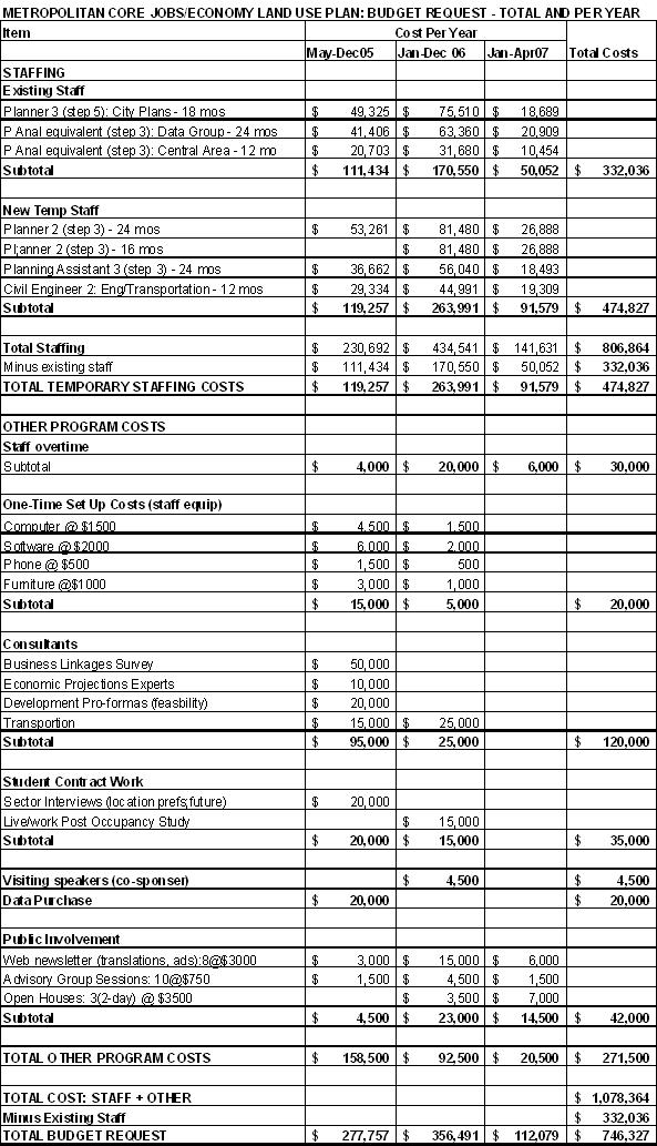
C. THAT Council approve hiring the following temporary staff: Planner 2 and Planning Assistant 3 for 24 months commencing in May 2005; Civil Engineer 2 half-time for 24 months commencing in May 2005, and Planner 2 for 16 months commencing in January 2006; at an estimated cost of $474,800 (pro-rated) including benefits. Funding to be added to the Community Services Group and Engineering Services operating budgets, without offset.
D. THAT Council authorize a budget of $271,500 to cover other program costs (consulting services, public consultation costs, etc.) for 24 months commencing in May 2005. Funding to be added to the Community Services Group and Engineering Services operating budgets without offset:
2005 $158,500
2006 $ 92,500
2007 $ 20,500
GENERAL MANAGER'S COMMENTS
The General Manager of Community Services RECOMMENDS approval of A, B, C, and D.
COUNCIL POLICY
Central Area Plan: In December 1991 City Council adopted the Central Area Plan: Goals and Land Use. In subsequent years Council adopted or amended several official development plans and zoning bylaws which implemented many aspects of the Central Area Plan.
CityPlan: In June 1995 City Council adopted CityPlan which contains various Directions related to this report including: maintaining a diverse economy and increasing jobs; priorizing walking, biking and transit use over car use; and recognizing the unique role of the Downtown and the Central Area.
Transportation Plans: In 1997 City Council adopted the Vancouver Transportation Plan, and in 2002 the Downtown Transportation Plan, both of which contain policies for transit and other transportation improvements that are based on achieving a certain number of employees and residents in the Central Area.
Downtown Interim Policies: On May 20, 2004, City Council adopted the Downtown District Interim Policies for New Residential in Areas C and F; and for Conversion of Existing Office Space to Residential Use. These policies were put in place to limit additional residential development pending further study of land needs for future employment use. Council also asked for a report back with terms of reference for a longer term land use study.
Job creation: On September 28, 2004 City Council adopted a resolution to encourage job creation and protection of existing employment as a key objective of City policy.
SUMMARY AND PURPOSE
This report outlines a major planning initiative to develop a long term land use policy plan to accommodate the future economy and jobs in the Metropolitan Core of Vancouver, and seeks Council approval of the terms of reference, staff, and funding required. The Metropolitan Core extends to 16th on the south and Clark on the east, containing 2/3 of the city's jobs.
This policy work responds to the May 2004 Council request to report back on terms of reference for a study which will lead to resolution of the future land use for the Downtown Interim Policy area in a broader context.
The Metro Core Jobs and Economy Land Use Plan will provide land use policies to replace the Interim Policy and for other employment areas within the Core. For areas in the Core with concurrent studies underway (False Creek Flats, the Port Strategic Plan, and Downtown Eastside Economic Revitalization), this work will provide an overall context and share key information and policy development. Finally, as this study progresses, it will provide basic information to lay the groundwork for subsequently addressing economic-related land use questions in other parts of the city and region.
It has been almost two decades since the research that led to the Central Area Plan: Goals and Land Use, adopted in 1991 and implemented through various zoning changes. New residential neighbourhoods have developed successfully over the past 15 years. Now, pressure is being felt to allow residential in areas that had been set aside for economic activities and to convert commercial buildings to residential. This presents challenges in ensuring we have appropriate land supply and zoning for the future jobs and services that should be located in the Core.
The Metropolitan Core Jobs and Economy Land Use Plan (Terms of Reference detailed in Appendix A) will start by understanding the current situation, and then project a range of futures for economic activity and for land supply and associated transportation and infrastructure capacity. This will lead to a better understanding of the land use and infrastructure issues we face in accommodating different possible economic futures. Subsequently, various policy options will be developed and evaluated, before being incorporated into a Policy Plan. The study will involve all the various interests who have a stake in the future of the economy of the Core using a range of consultation techniques.
The timing of this project to approval of the full Policy Plan by Council is two years. However, a major decision point will occur before 18 months, when an Issues Report is presented to Council. At this time, the existence and scale of issues related to various sub-areas of the Core will be outlined. For the Interim Policy area in particular, as issues become clearer leading to the Issues Report, a staff team will be examining feasible policy options. This means that resolution of the Interim Policy may be able to occur earlier than the rest of the Policy Plan. As well, by this time, the information base provided will assist other economy-related planning outside the Metropolitan Core.
Some existing staff in Planning and Engineering are available to undertake the work. However, in order to complete the study, temporary staff are required. In addition, funding for other costs such as consultant studies and public consultation is also requested.
Prior to finalizing the Terms of Reference for this study, a draft was made available for review and comment by key external groups (UDI, DVA, DVBIA, Board of Trade, BOMA, NAOIP, GVRD, etc). There is a widely shared interest in, and support for, undertaking this study as expeditiously as possible.
BACKGROUND
1. Waterfront Plans
In the 1970s, major land use changes related to the economy began in the Central Area, with the transformation of South False Creek from industrial to residential. This was followed over the next two decades by plans and rezonings from industrial to residential around the rest of the Creek and on Burrard Inlet, creating new communities in East and North False Creek, in Coal Harbour, and most recently planning in South East False Creek.
2. The Central Area Plan
In 1991, confirming and expanding upon the waterfront changes, a new vision for Vancouver's Central Area was crystallized in the Central Area Plan: Goals and Land Use Policy and adopted by Council. While the earlier changes had begun the transformation of industrial land, the new Plan changed the commercial land use nature of the Central Area.
The essential land use focus of the vision was to have two smaller, more focussed office areas in the downtown CBD and "Uptown" Central Broadway, surrounded by new high density residential neighbourhoods in Downtown South, Coal Harbour, and False Creek. Some areas on the periphery of the CBD core were to be "choice of use," with commercial or residential at the option of the developer. These major changes in previous land use policy were proposed in order to improve the balance between employment, residential, and transportation.
Other key land use directions in the 1991 Central Area Plan were to protect light industrial/service opportunities in nearby areas like Burrard Slopes, Mt. Pleasant, and the False Creek Flats to serve the needs of both the CBD and new residential areas; to allow "choice of use" as a means to preserve heritage in areas like Gastown, Chinatown, Yaletown, and Victory Square; and to target retail to key pedestrian streets.
In the five or six years after 1991, many (but not all) of these directions were implemented through detailed plans, zoning, and guidelines changes; public benefits plans; and Development Cost Levies bylaws.
Today, the new residential neighbourhoods have been realized very successfully, and faster than anticipated. The "choice of use" areas have also seen substantial development, mainly residential.
3. Today's Challenges
It has been 15 years since the Central Area Plan was approved, and about 20 years since the research and analysis on which it was based was done. Here are a few of the challenges we now face, that relate to the area's economic role in the city and region:
· Office development in the CBD has been somewhat slower than anticipated. Residential demand continues to be very strong, and residential land values very high. There is pressure for residential development in the area designated for CBD expansion, which might jeopardize the CBD's future economic role. On May 20, 2004, Council adopted the Downtown District Interim Policies for Residential in Areas C and F et al. to prevent residential development in the CBD and CBD expansion area from displacing commercial capacity, pending a long term land use review in these areas. Council also requested a report back on terms of reference for the land use review -which is this report.
· Heritage buildings in areas like Gastown and Yaletown have become home to many firms in the "new economy," which did not exist when the Central Area Plan was prepared. Current policy to allow residential use in heritage restorations could see significant displacement or limiting of this economic activity.
· Burrard Slopes and Mt. Pleasant light industrial/service areas are seeing intensified use by city-serving businesses, "new economy" firms, and businesses relocating from downtown residential areas. These lands are also under pressure from residential development. In False Creek Flats planning is underway to determine future land uses.
· New housing has been very successful in the Central Area, playing a key role in creating a balanced, vital, and alive downtown. New types of mixed use and live-work are being built. More information is needed to assist in Identifying future locations and types of development for continued appropriate residential growth, along with ensuring a land supply for economic activities.
It is important to now review the Metropolitan Core jobs, economy, and land use, and chart a path for the next decades. Unlike in 1991, when we had significant amounts of underused land, the Central Area has become much more developed. Land use decisions now assume more significance to protect or foreclose future opportunities. Having adequate and appropriate land and zoning is an important factor in meeting City and regional goals of encouraging jobs and healthy economic development. Land use for economic activity must also be compatible with transportation policy, including transit ridership targets, and has impacts on the City tax base and achieving a wide range of other City and regional goals.
DISCUSSION
1. Study Description
Recommendation A is to adopt the Terms of Reference (in Appendix A) for the study that will lead to a Metropolitan Core Jobs and Economy Land Use Plan. The study team will report to the Directors of City Plans and Current Planning, who will be jointly responsible. City Council will be kept informed by memos and briefings, as well as formal reports at key points.
The Terms of Reference provide a detailed description of all aspects of the study. An outline is provided below.
a. Study Scope
The ultimate study purpose is to develop a Policy Plan on future land supply and zoning in the Metropolitan Core - in the context of the rest of the city, and region, and beyond - that will:
· Provide for future economic development and jobs, and
· Accommodate the businesses and facilities that meet the goods, services, and activities needs of core residents, employees, and visitors.
The policy time horizon will be to the year 2031, while also noting shorter term and longer term factors where relevant.
The study will look at all economic sectors (i.e. professional services, financial services, retail, tourism, arts and culture, high tech, education, etc.), and at both the "local-serving" and "export-oriented" economy.
It will use established, adopted City goals as a basis on which to identify issues and evaluate options. These goals come from a range of sources: CityPlan, Vancouver Transportation Plan, Vancouver Sustainability Principles, etc.
While the focus will be on land use, the study will also include other related factors - i.e., key "one-of-a-kind" recreational and cultural places and facilities, and transportation and utilities. Transportation, in particular, along with land use, is an important aspect that affects the level of economic activity and employment that can be accommodated.
b. Study Area and Interrelationships
The study area is the Metropolitan Core - south to 16th Avenue and east to Clark Drive. The GVRD definition of the Metropolitan Core, similar to our definition of the Central Area, extends only to Main Street on the east. However, this study extends the Core boundary farther east to include nearby areas interconnected with the rest of the Core. This study pertains to different sub-areas within the Core in several ways:
· Information Base: Information will be collected and analyzed for the Metropolitan Core study area as a whole, providing a basic understanding and context of the economy of this area and its role in the city and region.
· Policy Development: Policy options will be focussed on sub-areas where no other planning is occurring, including the Downtown Interim Policy area. For areas that do have concurrent area planning programs, such as the Flats, this study will provide an overall context and share data collection, analysis, and policy development.
In addition, the study results and understandings of the economy will inform future work, beyond the Core, related to city-wide and regional economy-related land use and transportation issues.
c. Steps and Products
The study will follow five main steps over two years, with products at key points:
Step 1 Understanding Yesterday and Today
Step 1 assembles information on the current economic picture (all individual sectors, as well as the overall economic structure). It also researches the current urban development picture, including land use, transportation, and utilities. This step produces a series of Information Sheets, maps, and data. As well, studies and reports on the economy from many sources are being compiled into an Annotated Bibliography.
Step 2 Projecting Tomorrow
Step 2 predicts a range of economic and urban development futures. Economic futures will be based on a variety of factors, including trends and internal and external influences (demographics, technology, etc.) This gives an idea of the "demand" for different types of space and locations for businesses. The urban development futures, will show the "supply" of land and associated infrastructure that is be available under current zoning and plans. The products from this step are Economic and Development Projections.
Step 3 Assessing the Fit
Step 3 compares the projections, and assesses how well the future economic needs will be met by the future development and infrastructure pattern. Matches and mismatches are examined in the light of City goals. The issues that need to be addressed by policy are identified. The product is an Issues Report that goes to City Council for approval. This is a key decision point in the study. It will define where there are and are not land use and/or infrastructure issues related to the economy and the scope of those issues. For the Interim Policy area, this may allow Council to decide whether to pursue more employment-oriented land use options for this area in advance of full policy development for other Core sub-areas. (By the end of Step 3, there is also a key information base to pursue economy issues outside the Core.)
Step 4 Policies for the Future
Step 4 develops policy options to address the identified issues, and evaluates them in the light of City goals. The selected options form the Policy Plan. Products of this step are Policy Options, a Draft Policy Plan, and a final Policy Plan. As issues become clearer during the previous step, a staff team will begin examining the feasibility of policy options for the Interim Policy area, with the intent of resolving the policies for this area sooner, if possible, than for the rest of the Policy Plan.
Step 5 Actions for Tomorrow
Step 5 is the stage at which the approved policies in the Plan are implemented through changes to zoning, or other appropriate means. The work scope and resources necessary will be reported on at a future date, when more is known about what will be required. At this point we know there are likely to be changes to the zoning to replace the Interim Policy. Based on the earlier policy work for this area described in Step 4, this implementation work may be able to occur sooner than for the implementation work that may be needed in other areas of the Core.
d. Consultation
The consultation process will encompass the full range of interested parties: business owners and employees in the various economic sectors, landowners, real estate development interests, residents, and academics. It will also recognize the different levels of interest that people have, from wanting active involvement to wanting to be kept informed.
A key component will be the formation of an Advisory Group of about 30 members to provide advice to staff through review and evaluation of products at key points during the study. Staff will seek nominees and put together a wide cross-section of interests to serve on the Advisory Group.
There is also a long list of interested organizations, public agencies, firms, institutions, and individuals who will want to keep in touch, and be able to express opinions at key points. A series of e-mailings will draw their attention to the periodic web-based newsletters, which will in turn provide web links to the background information and products of the study at each step. There will also be open houses at three points, as well as staff presentations at meetings of key organizations.
The Planning study team will work closely with Engineering (transportation and utilities) and with other related projects, such as RAV, the Downtown Eastside, and False Creek Flats, as well as with Finance. Other City departments and agencies will also be interested in the outcomes of this study, including Engineering (other branches), Properties, Housing , Social Planning, Cultural Affairs, Heritage, and other Planning programs, as well as the GVRD. They will be kept informed throughout the study, and be invited to workshops to provide input at key points.
Prior to finalizing the Terms of Reference for this study, a draft was made available for review and comment by key external groups (e.g., Board of Trade, Downtown Vancouver Association, Downtown Vancouver BIA, Urban Development Institute, National Association of Industrial and Office Properties, Building Owners and Managers Association, GVRD) and internal staff groups. As was the case with the Downtown District Interim Policies for New Residential, there is a widely shared interest in, and support for, undertaking this study as expeditiously as possible.
2. Resources Required
A number of existing policy and data staff are available in Planning to work on this program and have begun data collection and research. There are also Engineering staff working on related projects (DT Transportation Plan implementation, False Creek Flats, DT Streetcar) who will be able to provide supporting data and analysis including information from consultant work. However, additional temporary staffing and other program costs are required. Recommendation C is to approve creating and funding four temporary staff positions:
· Planner and Planning Assistant for 24 months to focus on overall economic and land use aspects of the study and to coordinate and guide the study including public consultation;
· Planner for 16 months (beginning part-way through the study) to focus on policy development for the Interim Policy area; and
· Civil Engineer for 12 months (half time throughout the study) to focus on transportation capacities and constraints in servicing the employment land uses. (For example, the Downtown Transportation Plan which provides much needed information for this study, may need to expand its information base to look past the 2021 employment target. Also the Central Broadway corridor has not had the attention that other parts of the Core have had in transportation analysis.)
Recommendation D is to approve funding for other program costs including computer and office set-up costs; consulting and contract services for research; data purchase; and consultation costs.
These resources will take the program up to the end of Step 4, the adoption of the Plan. The work and resources required to undertake Step 5, the implementation of the Plan, (e.g., rezoning for the CBD), will be reported to Council at a later date, likely close to when the Plan is approved.
FINANCIAL IMPLICATIONS
The total project costs are estimated at $1,078,300, which includes existing available staffing resources of $332,000. Temporary resources required are, therefore, $746,300 as shown in the following table. A detailed budget estimate is provided in Appendix B. (It is anticipated at this time that no extra staffing resource will be required to complete Steps 1 through 4 of the study, beyond the resources identified here.)
2005
|
2006
|
2007
|
Total | |
New Temp Staff |
$119,257 |
$263,991 |
$91,579 |
$474,800 |
Other Costs (Data Purchase, Consultants, Consultation, etc) |
$158,500 |
$ 92,500 |
$20,500 |
$271,500 |
Total |
$277,757 |
$356,491 |
$112,079 |
$746,300 |
Terms of reference and budget for the policy implementation step, step 5, are not included in this report. They will be determined once the locations and scale of economy-related land use issues are known and will be reported to Council for approval. A best guess as to budget implications for this later work would be that existing staff would be available once their current projects are gradually completed. In that case, the budget needs would be for public consultation, and could be in the area of $200,000 to cover implementation work in several sub-areas.
The Co-Directors of Planning note that the Metropolitan Core Jobs, Economy, and Land Use Plan will be critical in ensuring the ongoing economic health and vibrancy of the Metropolitan Core, which is key to the City's goals for jobs, transit, and a sound financial footing, and is an important component of the city and regional economy. It is important that the work be done in a timely manner, and that it involves all the affected interest groups.
CONCLUSION
The Metropolitan Core Jobs and Economy Land Use Plan will ensure that the city has the appropriate land supply and zoning regulations, and associated infrastructure, to accommodate the future economy of the Metropolitan Core over the next 25 years. This area extending south to 16th and east to Clark now houses 2/3 of the city's jobs. The proposed Terms of Reference provide a roadmap for the study, outlining the purpose, steps and consultation. The requested funding, together with the staff team already available, will enable this work to proceed, producing an Issues Report prior to 18 months and a full Policy Plan in two years. This work includes resolution of the Downtown District Interim Policies and policies to address other economy-related land use issues on commercial and industrial lands in the Core, as well as providing an information base for economy-related planning outside the Core.
* * * * *
![]()
APPENDIX B
BUDGET ESTIMATE