|
CITY OF VANCOUVER ADMINISTRATIVE REPORT |

Date: |
November 16, 2004 | |
Author: |
Sandy James; Linda Chow | |
Phone No.: |
(604) 873-7679; (604) 873-7305 | |
RTS No.: |
4494 | |
CC File No.: |
5340 | |
Meeting Date: |
November 30, 2004 |
TO: |
Standing Committee on Transportation and Traffic |
FROM: |
General Manager of Engineering Services
|
SUBJECT: |
Completion of the Ridgeway Greenway-West Extension |
RECOMMENDATION
THAT Council approve the Ridgeway Greenway - West Extension as a dual route corridor identified in this report as Route A and Route G.
GENERAL MANAGER'S COMMENTS
The General Manager of Engineering Services recommends approval of this report.
COUNCIL POLICY
On July 18, 1995, Council adopted the Vancouver Greenways Plan. This plan supported the development of Greenways to improve walking and cycling opportunities to local connections and promote community building.
Council's transportation policy places the highest priority on pedestrians followed by cyclists.
PURPOSE
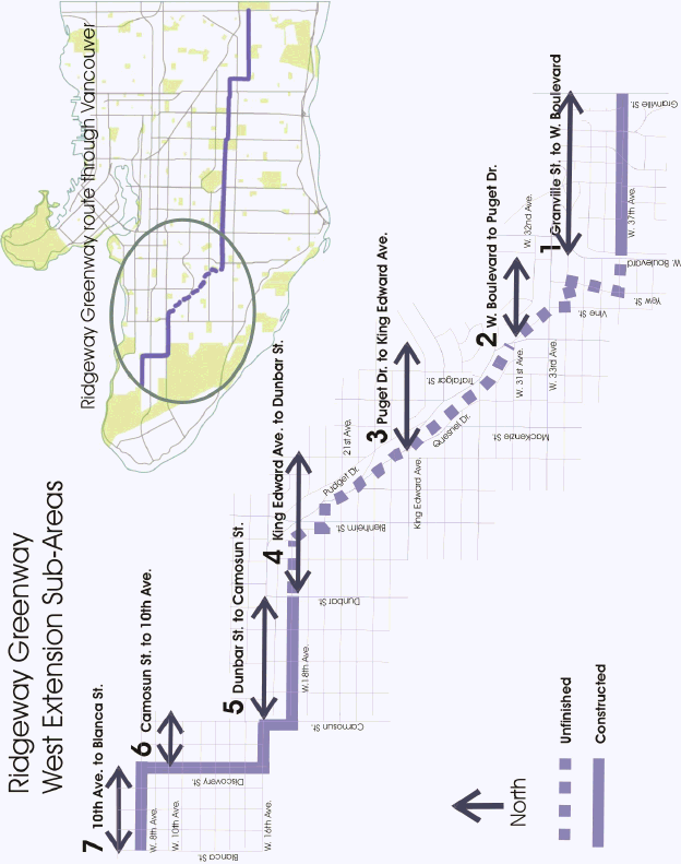
The purpose of this report is to establish the routing for the Ridgeway Greenway between Puget Drive and 31st Avenue to Quesnel Drive and King Edward Avenue (Sub-area 3, see Appendix A) of the Ridgeway Greenway to enable the detailed design and completion of this cross town greenway.
BACKGROUND
In 1995, Council adopted the Vancouver Greenways Plan and identified the Ridgeway as the first of fourteen citywide greenways to be constructed. The Ridgeway runs east-west and generally follows the ridge or the high point of the city connecting Pacific Spirit Park and Central Park in Burnaby. The portion in Sub-area 3 between West King Edward Avenue and Quesnel Drive to West 31st Avenue and Puget Drive is the final sequence that will complete this greenway.
In October 1998, Council considered the routing of the western portion of the Ridgeway which runs from the intersections of West 37th and Granville to West 8th and Blanca. At that time, the Ridgeway was divided into seven sub-areas for the purpose of public consultation. Based on community feedback, routes through all areas were approved except for Sub-area 3. The route through Sub-area 3 was not resolved due to a lack of community consensus on a preferred route.
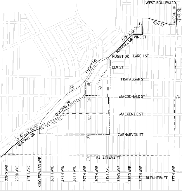
Council instructed staff to conduct further public process on six potential routes through Sub-area 3 and also to include consideration of an alternate route for the Ridgeway Greenway along West 37th to Balaclava, outside Sub-area 3. (In this report, the routes through Sub-area 3 are labeled Routes A to F and the route along West 37th to Balaclava is called Route G. See Appendix B).
Sub-area 3 is generally located between West King Edward Avenue and Quesnel Drive to the north and West 31st Avenue and Puget Drive to the south as illustrated in Appendix A.
DISCUSSION
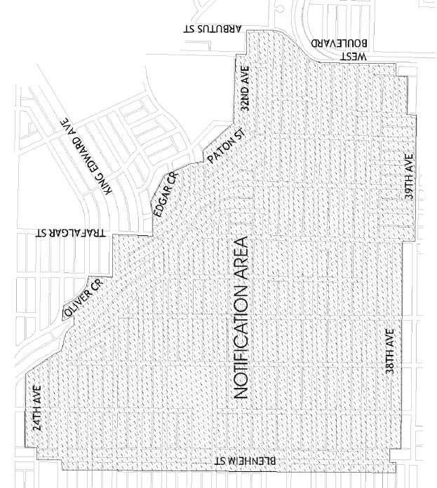
In the Spring of 2004 Greenways staff began the public process for choosing a Ridgeway route through Sub-area 3. An advertisement was placed in the Courier and flyers were delivered to the notification area (as outlined in Appendix C) for an Open House that was held at the Kerrisdale Community Centre on June 16, 2004. The intent of the open house was to re-introduce the project to the community, gather initial feedback on the proposed routes and explain the process. Project objectives were also reviewed by the community and these include following the topographic ridge of the City, taking advantage of city views, and making walking safer. Over seventy people attended this first open house.
Proposed routing issues expressed by the community included safety at busy intersections, maintaining access to views on the ridge routes, directness of routes, and concerns about steep elevation changes.
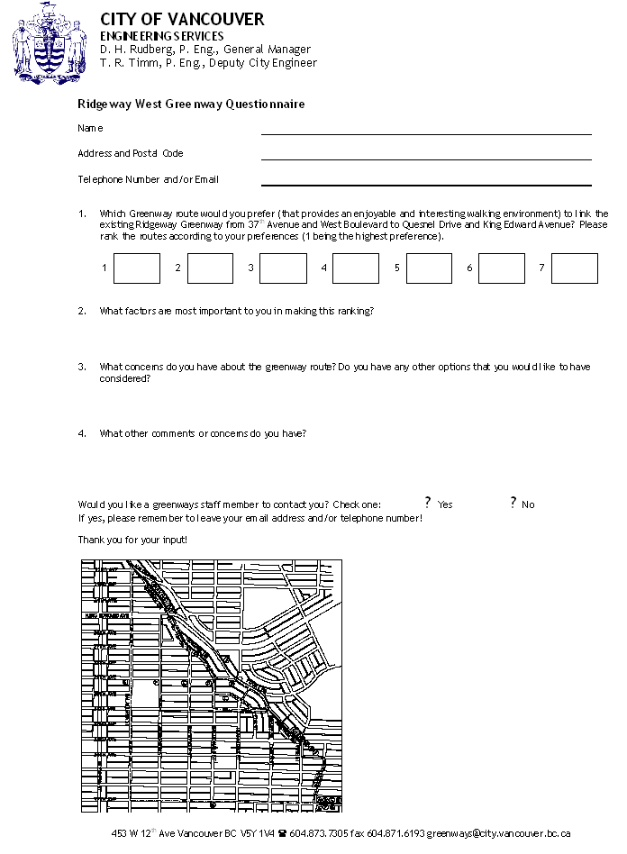
A survey was sent out in July 2004 to the notification area asking residents their preference for a greenway route. (See Appendix D for a copy of the questionnaire.)
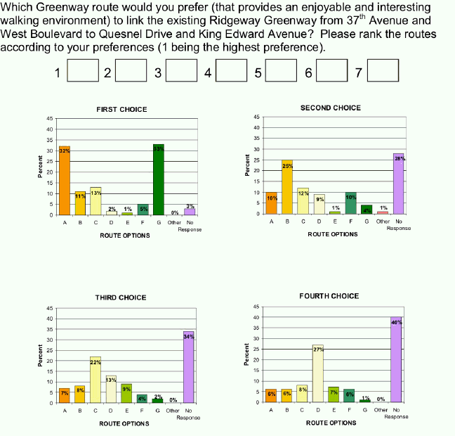
The questionnaire results (see Appendix E and Table 1) indicated that support for a greenway route through Sub-area 3 was 33 percent for Route G which does not go through the sub-area.
Route A was the residents' preferred route through the sub-area and received 32 percent support.
Route C, the second choice through the sub-area, received 13 percent of survey support.
Table 1: Questionnaire Results - First Choice
Route Option |
Percent (%) |
A |
32 |
B |
11 |
C |
13 |
D |
2 |
E |
1 |
F |
5 |
G |
33 |
No response |
3 |
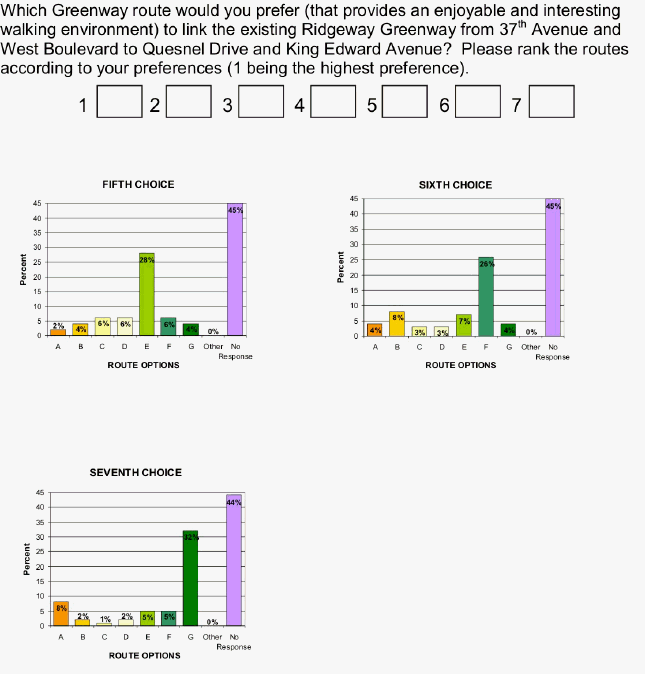
Results of the survey may have been skewed by a letter (see Appendix F) distributed to the notification area by two residents that advocated that survey respondents indicate their route preference for Route G only (outside the sub-area) and not include a second or third choice for a route within the sub-area. This meant that analyzing second and third route preferences in the survey would not be statistically valid.
A second Open House was held at the Kerrisdale Community Centre on September 22, 2004 to report back to the community that the survey results were inconclusive, and that staff would be reporting to Council for guidance on Sub-area 3 Ridgeway Greenway route selection.
Route G, which proceeds from 37th Avenue to Balaclava and then north to King Edward Avenue circumvents the sub-area. It does not follow the topographic ridge nor does it have view opportunities. However, Route G is flatter and more accessible to pedestrians and cyclists who find elevation changes challenging.
Route A follows Puget Drive and provides a safe crossing at King Edward Avenue, but it is below the topographic ridge, has a challenging connection along King Edward Avenue, and is on a busy street. Route A does go through the sub-area and the route would link up with the Council approved Ridgeway route to the north and east.
Route C, which generally follows Quesnel Drive was the City of Vancouver's originally proposed route in the 1998 process, as it best met the objectives of following the ridge, offering scenic views, and providing a safe pedestrian environment.
Staff therefore recommend that two routes be approved for the Ridgeway-Route G, which provides an accessible flatter route along West 37th Avenue to Balaclava and then north to King Edward Avenue, and Route A, which is below the topographic ridge of the City, has some scenic views, and provides a safe crossing of King Edward Avenue at Puget.
ALTERNATIVES/OPTIONS
The survey shows there is a desire for a safe, direct route that takes advantage of the spectacular views but is accessible to cyclists, pedestrians and disabled users who are uncomfortable dealing with steep inclines.
In response to this, staff recommends a dual route. The main greenway would follow Route A (see Appendix B) to take advantage of the direct connections to the approved Ridgeway route to the north and east, and a second greenway along Route G for those wishing gentler grades.
NEXT STEPS
If the proposed routes in this sub-area are approved, staff will work with the community on the detailed design and report back on costs and implementation of this segment. Both Routes A and G would require minimal signage, curb ramps in some locations, and some sidewalk improvements. Some intersections on Route A will need improvements for pedestrian safety and comfort, and these proposed improvements will be discussed with the community.
Approval of Route A would allow this segment to link to the previously approved sub-areas of the greenway to the north and east of Sub-area 3, and allow staff to proceed with the traffic calming public process which had been approved for Sub-area 4, but which has been delayed pending the decision on the routing through Sub-area 3.
Construction of these two segments will represent the final steps in the completion of the Ridgeway Greenway.
FINANCIAL IMPLICATIONS
The two routes would be constructed with minimal treatment, which would include sidewalk, curb ramps and signage. There is no cost estimate for this work as the details will be established through further public consultation once the routes are chosen.
CONCLUSION
The construction of two routes, Routes A and G would meet the Ridgeway Greenway and community objectives. The Ridgeway route along Route A would provide views for pedestrians, provide a safe crossing at King Edward Avenue, and a direct link with the approved Ridgeway routes to the north and to the east. Slope and accessibility issues would also be met by also adopting Route G, which is relatively free of grade, but does not follow the topographic ridge or have views.
* * * * *