Vancouver Community College
King Edward Campus
Policy Statement
Adopted by City Council ..........
DRAFT
CONTENTS
1. INTRODUCTION
2. BACKGROUND
2.1 History
2.2 VCC development needs
3. THE SITE AND CONTEXT
3.1 Description of Campus and Surroundings
3.2 Access and Parking
3.3 Policy context
4. LAND USE AND DENSITY
4.1 Existing uses
4.2 Proposed uses and density
4.3 Distribution of uses
5. URBAN DESIGN PRINCIPLES
5.1 General goals and principles
5.2 Campus precinct, identity and legibility
5.3 Built form and massing
5.4 Views
5.5 Open Space
5.6 Architectural expression
5.7 Public realm and linkages
5.8 Vehicular access, parking and servicing
6. TRAFFIC DEMAND MANAGEMENT STRATEGY
6.1 Introduction
6.2 Principles
7. COMMUNITY AMENITY STRATEGY
7.1 Introduction
7.2 Community needs and opportunities
7.3 Potential responses
8. SUSTAINABILITY
8.1 Sustainability principles
8.2 Green building principles
9. PHASING AND IMPLEMENTATION
9.1 Introduction
9.2 General principles
9.3 Delivery of Facilities and Infrastructure
1. INTRODUCTION
Vancouver Community College (VCC) proposes to carry out a phased expansion of its facilities at the King Edward Campus, located at 1155 East Broadway in Mount Pleasant. This expansion is intended both to resolve the severe space shortages affecting current operations and to provide new facilities to enable the College to meet the increasing demand for education and training in the city. The proposed expansion will require rezoning of the campus to amend the current CD-1 zoning.
In December 2003 Council authorized City Staff to carry out a planning process involving VCC, the local community and other interested parties to consider the issues raised by the proposed expansion of the campus and to develop an appropriate policy context. A key outcome of the planning policy process is the preparation by Staff of this Policy Statement document, which establishes the context within which a rezoning application can be considered.
The Policy Statement is structured as follows:
· Section 2 provides background to the proposals in terms of the history of the site and VCC's development needs.
· Section 3 provides a description of the campus site and its surroundings, and the existing policy context.
· Section 4 describes the program of facilities proposed on the campus and the level of new development expected.
· Section 5 outlines a series of urban design principles for the campus to guide the assessment of the rezoning and development proposals.
· Section 6 discusses the need for a Traffic Demand Management strategy for the campus.
· Section 7 assesses the community amenity needs which would arise from the proposals and discusses possible directions and opportunities to address these needs.
· Section 8 sets out the sustainability and green building principles which will need to be considered within the campus expansion proposals.
· Section 9 explains the phasing issues associated with the proposals and identifies a sequence for the delivery of key facilities and infrastructure.
2. BACKGROUND
2.1 History
VCC has been providing post-secondary education and training in Vancouver for the past 40 years and currently serves 25,000 full and part-time students a year in health, hospitality, business, English as a second language, adult basic education, career access, continuing education, trades and technology. These activities are divided between VCC's City Centre Campus and the King Edward Campus, as well as numerous rental facilities throughout Vancouver.
The King Edward Campus was opened in 1983 and has become the most heavily utilized major college campus in British Columbia with a total student population of over 8,400. Prior to the development of the campus the site comprised vacant land, a public park incorporating a sunken velodrome, a small manufacturing plant and the remains of a burnt out sawmill.
2.2 VCC Development Needs
The King Edward Campus comprises some 25 176m² (271,000ft²) of floorspace and was designed to accommodate 1,800 full time equivalent (FTE) students upon opening in 1983 (FTE is a standard unit used to represent student use of College facilities). However, by the 2003-2004 academic year the campus was serving some 3,500 FTE students. VCC is therefore experiencing critical space shortages for its current activities at the campus. In fact, the College would require 37% more floorspace to meet Provincial space planning guidelines at the current level of activity. In addition, the College is faced with the need to provide facilities for growth in order to continue to meet the ever increasing demands for education and job training from the residents of Vancouver.
VCC's long-term analysis suggests that the King Edward Campus requires 63 638m² (685,000ft²) of additional floorspace to meet the projected needs of the community over the next 10 years or so. As well as resolving current space shortages this would enable an expansion in the student population to approximately 7,300 FTE over that timeframe.
As a first phase of further development VCC's priority is to build a Health Sciences and Music facility of approximately 15 500m² (166,840ft²). This would enable the campus to increase its capacity to approximately 4,000 FTE students. Beyond this first phase the exact composition of new development is less clear as it will depend on future Provincial funding priorities as well as VCC's own academic focus. In addition to providing for the College's academic programs, new development will be required for complementary uses such as student-oriented food and retail facilities, amenities such as daycare and student oriented support facilities such as a library and study space. This Policy Statement is intended to be both robust and flexible enough to accommodate changes to the College's plans and priorities as later phases of expansion are brought forward.
3. THE SITE AND CONTEXT
3.1 Description of Campus and Surroundings
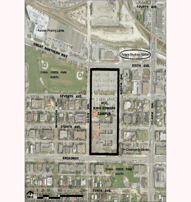
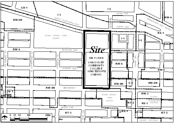
VCC's King Edward Campus occupies a rectangular 3.2ha (7.8 acre) area of land bordered by the 1100 Block of East Broadway to the south, Keith Drive to the east, Glen Drive to the west and Great Northern Way to the north. East 7th Avenue separates the campus into two full block parcels. The site and its context are illustrated on Figure 1: Site Context Plan and Plates 1 to 8.
The southerly block of the site slopes significantly from south to north, dropping some 20 metres from Broadway to 7th Avenue. This portion of the campus is occupied by a series of linked buildings which step down the slope, ranging from 2 to 4 storeys above grade. A network of courtyards and internal and external corridors provides circulation routes within and between these buildings. To the north of the main buildings lie the College's daycare facility, parking lots and servicing yard.
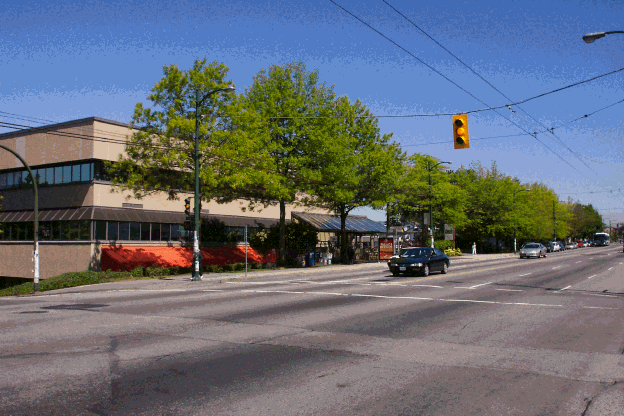
Apart from a two-storey block at the corner of Broadway and Glen the Broadway frontage of the campus is sunk into the slope of the site, meeting the sidewalk at grade. This enables views from Broadway across the campus to the Downtown skyline and the North Shore mountains, as well as the creation of a small plaza at grade which acts as the main pedestrian entrance to the campus.
Figure 1: Site context plan
1. View of campus from Broadway 2. Keith Drive frontage and community garden
3. View of Downtown skyline from 4. View of North Shore mountains from Broadway Broadway
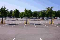
5. Campus internal courtyard 6. Parking lots dominate the northern part of the campus
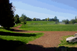
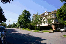
7. China Creek Park North 8. RM-4 properties on Glen Drive
Whilst Broadway is a busy vehicular route there is no commercial activity within the immediate vicinity of the campus, with the nearest significant commercial nodes clustered around Fraser and Broadway to the west and Commercial and Broadway to the east. In addition, there are gas station / convenience stores located at Broadway and Clark and 12th and Clark. The surrounding building stock on this stretch of Broadway comprises three and four storey apartment blocks interspersed with the occasional single family dwelling. Immediately opposite the campus on Broadway is South China Creek Park.
Along the Glen Drive frontage the campus buildings step down the slope at three and four stories, punctuated by two pedestrian entrances. To the west across Glen lie three and four-storey apartment blocks (zoned RM-4), built to a maximum density of 1.45FSR. North China Creek Park is situated across Glen at the northern end of the campus, between 7th Avenue and Great Northern Way. Glen Drive is a relatively busy route, requiring traffic signals at both Broadway and Great Northern Way.
Along the Keith Drive frontage the two-storey campus buildings are set back from the street and roughly match the scale of the apartment blocks to the east (zoned RM-4). Access between Keith Drive and Broadway is restricted to pedestrians only via a footpath running up the slope through a community garden. Traffic on Keith is consequently light, though some servicing access to the campus does occur from the street. Between 7th Avenue and Great Northern Way the area to the east of the campus is zoned I-1, with part of this block occupied by the SPCA facility.
The northern edge of the campus is defined by Great Northern Way, a fast moving vehicular arterial route skirting False Creek Flats. The edge of the campus abutting Great Northern Way is occupied by a parking lot, which is accessed from 7th Avenue. To the north across Great Northern Way lie a series of low-rise light industrial buildings (zoned I-3) with the former Finning Lands (recently rezoned CD-1) to the west. The future of this area is currently being assessed as part of the False Creek Flats planning study. In particular, the former Finning Lands are expected to be redeveloped at higher densities for a mixture of uses including education, hi-tech industry, residential and commercial.
The Policy Statement seeks to provide a framework for the expansion of the King Edward Campus which takes account of the fact that the site context is likely to undergo change during the period over which the campus is developed, particularly given the construction of a new Skytrain station at Clark and Great Northern Way. These changes relate most notably to the area to the north of the site which will be considered as part of the False Creek Flats planning process but also other potential areas of change elsewhere in the neighbourhood, including the residential blocks to the east and west. The evolving planning and development context to the campus will continue to be monitored as the rezoning of the site is assessed.
3.2 Access and parking
The campus is relatively well served by transit, with the Broadway corridor serviced by both Translink's regular trolley buses (#9) and the B-Line buses (#99). Trolley bus #22 also serves the campus, running north-south along Clark and Knight. The Broadway and Commercial Drive Skytrain stations are within a ten minute walk of the campus. In addition, a new Millenium Line VCC Skytrain station located immediately to the north-east of the campus is due to open in 2005, significantly improving transit access. Approximately 40% of students and staff currently use transit for their trips to the campus. The site also has good access to bike routes running east-west along 7th Avenue and north-south along Glen Drive.
A total of 533 parking stalls are provided on the campus, the majority of which are split between the `Economy Lot' (located between 7th and Great Northern Way) and the `Preferred Lot' (between 7th and the college buildings) which currently charge $1.50 per day and $2 per day respectively. Access to the Economy Lot is from 7th Avenue and to the Preferred Lot from either 7th or Keith. Recent surveys indicate that there is considerable spare capacity in the on-site parking lots and that a substantial proportion of staff and students choose to park off-site, mainly in the residential neighbourhoods to the east and west of the campus, most of which are not currently subject to parking restrictions.
3.3 Policy Context
Current Zoning
Figure 2 illustrates the current zoning of the site and adjacent areas. Following a Public Hearing in June 1980, Council conditionally approved the rezoning of the site from M-1 (Industrial District) and RM-3A (Multiple Dwelling District) to CD-1 (Comprehensive Development District). The Zoning Bylaw sets out the key development parameters for the site, as follows:
Permitted Uses
· School and recreational uses (Vancouver Community College), including:
· instructional classrooms
· regional office
· continuing education offices and classrooms
· vocational trade shops
· library, cafeteria, gymnasium and lecture theatre
· Accessory uses customarily ancillary to the above, including off-street parking and loading.
Floor Space Ratio
· The floorspace ratio for Phase 1 shall not exceed 0.82.
· The floorspace ratio for Phases 1 and 2 combined shall not exceed 0.9.
· [Note: Phase 2 was never built.]
Off-Street Parking
· A minimum of 540 off-street parking spaces for Phase 1.
View Preservation
One of the conditions of the rezoning was that the detailed scheme of development be first approved by the Director of Planning, having due regard to "...view preservation from Broadway...". This related to the previous, partially open and public use of the site and the views achieved across it.
In September 1980 the Development Permit Board conditionally approved the subsequent Development Application, which comprised a form of development which established view corridors from Broadway to the Downtown skyline and North Shore mountains. Although these views are not among the view cones formally approved by Council, the Council-approved form of development for the site reflects the clear intention to preserve views of the Downtown and North Shore Mountains from this part of Broadway.
Figure 2: Current zoning plan
4. LAND USE AND DENSITY
4.1 Existing Uses
The King Edward Campus provides facilities for a total population of over 8,400 students (approx 3,500 FTE) and currently operates programs in English as a second language, Music, University transfer, trades, continuing education, High School Completion and Upgrading, Adult Special Education as well as a variety of vocational training opportunities. In addition to providing teaching, study and research space for these programs the campus includes a variety of complementary facilities such as a bookstore, cafeteria and daycare. The existing facilities comprise a total of 25 176m² (271,000ft²).
4.2 Proposed uses and density
The proposed expansion of the campus is expected to include additional teaching and complementary facilities comprising 63 638m² (685,000ft²) of new floorspace. This level of new development would represent an increase in FSR from the current built FSR level of 0.78 (note that 0.9 is allowable under the current zoning) to approximately 2.8.
Whilst the nature of the proposed uses broadly reflects the current educational use of the site, which has become integrated into the surrounding neighbourhood since its opening in the early 1980s, the scale of the expansion in floorspace would represent a very significant increase in the density of development on the site. In order to assess this increased density careful consideration will need to be given to building height, form, orientation and massing and its impact on existing views and neighbouring residential properties. Section 5: Urban Design Principles provides guidance on how these issues should be addressed.
The proposed expansion of facilities will also significantly affect the intensity of use on the site through expanded student and faculty populations. It is projected that the campus could accommodate some 7,300 FTE students at completion of the development. This will require issues such as pedestrian and vehicular access, traffic management, parking and servicing to be comprehensively addressed and potential negative impacts for the neighbourhood mitigated. Section 5: Urban Design Principles and Section 6: Traffic Demand Management provide guidance on how these issues should be addressed.
At this stage the precise mix and level of different facilities has not been fully determined. The final mix of uses will need to provide a balance between teaching and support facilities to create a campus which meets the needs of students and faculty and is as self-sustaining as possible. The proposals should also include facilities which serve the needs of the local community.
The campus expansion is expected to provide for a mix of facilities including:
· Teaching facilities
· Informal study space
· Library
· Administrative and support facilities
· Social spaces
· Performance venues
· Indoor recreational facilities
· Complementary food and drink services
· Complementary retail/commercial facilities
4.3 Distribution of Uses
The following general principles should be applied to the distribution of uses and activities across the site:
1. The distribution of teaching and study facilities should be organised in a manner which, where appropriate, achieves operational synergies between and within faculties.
2. Active uses should be located to provide animation to key routes and spaces created within and around the campus. Examples of such uses include retail and food and drink services.
3. Uses which give rise to noise or other nuisances should be located away from residential adjacencies or otherwise mitigated.
5. URBAN DESIGN PRINCIPLES
This section sets out a series of urban design principles to guide the planning of the development and the consideration of a rezoning application for the site. These principles are intended to highlight opportunities and constraints associated with the redevelopment of the campus and to identify key urban design goals. As such they do not prescribe specific solutions but instead provide a framework of sound principles which encourage an appropriate development response to the site and its context without stifling innovation at either the rezoning or more detailed design stages.
5.1 General Goals and Principles
The following statements set out the broad goals and principles for the campus. These are followed by more specific urban design principles contained within sections covering the fundamental aspects of the existing and future development.
1. To foster a more legible College organization with a stronger sense of identity.
2. To establish a stronger identity and sense of place for the College through the redevelopment of unattractive and underused areas of the campus.
3. To establish a form of development that respects and responds to the existing and planned future neighbourhood context.
4. To preserve views across the site to the Downtown Skyline and North Shore mountains from Broadway whilst improving the College's presence on Broadway.
5. To integrate the campus more effectively with Broadway, the surrounding residential neighbourhood and future neighbourhood context with increased permeability through an enhanced network of pedestrian connections into and within the campus.
6. To capitalize on opportunities arising from the site's unique physical characteristics (slope) with enhanced roofscapes and surface treatments.
7. To enhance the streetscape around the site and to contribute to the pedestrian environment of both the neighbourhood and campus with active pedestrian-oriented uses which provide interest, comfort, and security.
8. To provide a range of complementary facilities which support the College and serve the needs of the local community centred on 7th Avenue, creating a clearly identifiable neighbourhood focus as an interface providing commercial services to the local community and College students and staff.
9. To plan vehicular access, parking and circulation to complement the urban design objective of creating a positive pedestrian environment and minimize impacts on the surrounding residential areas.
11. To reinforce transit orientation for students, staff and visitors to the campus by strengthening links to Broadway and the new VCC Skytrain Station.
12. To accommodate the future design of Great Northern Way.
13. To orient and configure new buildings to help define open space and street edges to create spaces where people can interact and relax.
14. To minimise opportunities for crime through careful consideration of built form, spatial layout, accessibility and natural surveillance.
15. To integrate sustainability measures into the campus plan and built form.
16. To accommodate flexibility in the campus plan to allow for growth and change in educational needs over time.
5.2. Campus Precinct, Identity and Legibility
This section deals with the campus's existing, very limited presence and identity along Broadway and it's future presence along Great Northern Way and the legibility of the building forms and edges within the precinct.
Campus Precinct
The campus precinct is comprised of two large sites consisting of entire blocks. The master plan is to expand the campus program space over the full extent of each block resulting in the campus precinct being linked by a more pedestrian oriented 7th Avenue. 7th Avenue is also part of the BC Parkway bike route and serves as an important neighbourhood street as it provides an opportunity for the residential neighbourhood to the east of the campus to link with neighbourhoods west of the campus, China Creek Park North, and the future Mount Pleasant Community Centre that will be located at 7th Avenue and Main Street. The treatment of 7th Avenue will need to accommodate these existing movements whilst also knitting the two blocks of the campus precinct together.
7th Avenue Neighbourhood Facilities
There is potential for 7th Avenue to become a focus of activity for both the campus and wider neighbourhood, providing facilities and services as a focus for the local community. These facilities should be pedestrian and neighbourhood oriented. They should seek to serve local needs and create a place for interaction between the College and the wider community. The development of these facilities should be planned in the context of existing and emerging plans elsewhere in the neighbourhood.
Campus Identity and Presence on Broadway
The campus currently achieves little presence on Broadway and provides few clues about point of entry or activities present. The campus's existing principle entry is located at the southwest corner along Broadway. Access into the campus is through depressed entry points at Broadway and along Glen Drive. The large plaza along Broadway, the existing building and public realm treatments contribute very little to the streetscape.
Legibility of Campus Environment and Wayfinding
The development needs of the campus will require a significant increase in building site coverage, generating large building forms that will have to fit together closely with limited open space opportunities between. The ability to orient oneself within the composition of buildings will be an important aspect that will need to be addressed. The campus plan will need to provide a high degree of legibility to orient students, staff and visitors to the primary movement corridors and access points within the campus and along its street edges.
Urban Design Principles
1. To develop a campus precinct by integrating 7th Avenue as an important pedestrian environment for both the College and the local community with facilities and activities which serve the needs of, and provide a meeting place for, the College and wider neighbourhood.
2. To create a greater sense of identity and sense of place along all of the College's street frontages, with particular consideration given to enhancing the existing Broadway frontage.
3. To significantly improve the quality and presence of the campus along the Broadway frontage by:
- Reinforcing the entrance to the principal circulation route (spine) using new building element(s), architectural features / signage and the introduction of active uses.
- Reinforcing the existing plaza as a focal element of the frontage through enhancement measures such as public art, street furniture and planting.
- Repairing the gap in the frontage caused by the existing below grade service yard on the Broadway frontage by improving the amenity and usability of this space. This should be considered in parallel with improvements to the pedestrian access between Broadway and Keith and the edge treatment of the community garden.
4. To orient people to the primary access points and movement corridors both within the campus and along its street edges using building forms to emphasize important nodes, entrances, links, public edges and places.
5. To complement the Great Northern Way frontage with public realm treatments and active uses that will enhance the campus's relationship to the new VCC SkyTrain Station with clear, direct pedestrian links to the principal circulation routes and nodes, including 7th Avenue.
5.3. Built Form and massing
The southern portion of the campus sits within the multi-family residential neighbourhood of Mount Pleasant (RM-4) having a density of 1.45 FSR and maximum height of 10.7m (35.1ft) and generally 4 storeys. To the north, across Great Northern Way is an industrial use zone, I-3 that permits an FSR of 3.0 and height of 18.3m (60ft), discretionary to 30.5m (100ft). To the east across Keith Drive, between 7th Avenue and Great Northern Way, the I-1 zone permits an FSR of 3.0 and a maximum building height of 18.3m (60ft). The site has a significant change in grade from Broadway down to 7th Avenue of approximately 20 m (65.6ft).
Given the residential character of the area surrounding the site, particularly south of 7th Avenue, a gradual transition in height is needed to maintain the ambience of the area and to avoid the College being out of scale with its context. Therefore, the east and west edges (Keith and Glen Drive) of the site should be of a scale sensitive to the neighbouring residential context. Additional height, within the site, could be supported with appropriate setbacks that will mitigate the building mass along these street frontages. The site slope should inform building massing and streetwall configuration. The proposals should also seek to respond, in terms of scale and massing, to the changing context to the north of the site.
While various depths of floor plates are needed to accommodate teaching spaces, student study areas, library needs and complementary facilities, large floor plates at higher levels can appear bulky and out of scale within this context. Large floor plate requirements should be located within the lower building mass.
Urban Design Principles
1. Along the Keith and Glen Drive frontages, new development should respect the scale of the residential neighbourhood with an objective of building heights to be generally no more than 3m (9.8ft) (i.e. approximately one residential storey) higher than the maximum height permitted under the existing (RM-4) zoning for the adjacent residential properties. Given the site slope, limited over-runs on height restriction would be considered provided that they are roughly balanced by under-runs on the same streetwall.
2. Additional building height, within the site, can be supported with appropriate setbacks (of at least 6m from the property line) that will mitigate the building mass along the Keith and Glen Drive frontages.
3. New buildings should be set back along Glen Drive to accommodate an enhanced pedestrian environment and respect the residential context. Public realm elements such as street trees, generous sidewalks, landscaping and seating should be accommodated.
4. New buildings should be set back along Keith Drive to accommodate an enhanced pedestrian environment and respect the residential context.
5. Where large floor plates are required to accommodate specific program needs, these should be located within the lower massing elements.
6. Higher massing elements should be configured to present their narrow dimension in a north-south orientation to minimize view blockage across the site.
7. Large and/or long building mass should be articulated to minimize its overall scale and bulkiness.
8. Building height and massing should be organized to minimize overshadowing of streets, buildings and spaces both within and adjacent to the campus.
9. An overly institutional uniformity in edge and massing treatments should be avoided.
10. Built form along Great Northern Way should be of a similar height and scale to that permitted within the I-3 context to the north.
11. New buildings and structures on the campus north of 7th Avenue should help to define the primary pedestrian route of Glen Drive and provide a strong built form edge for the east side of China Creek Park North in a manner consistent with the scale and height of the adjacent residential neighbourhood.
12. New development on the campus should not prejudice the utility of the community garden located at Keith and Broadway.
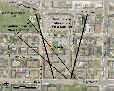
5.4 Views
Council's 1980 rezoning approval for the development of the campus was conditional on preserving long distance public views across the site from Broadway. This condition reflected the low-rise, open and public nature of the site associated with the previous use and the ability to use the change in grade. The subsequently approved form of development enables two key views from Broadway, as follows (see Figure 3: View corridors):
1. A view to the north-west of the Downtown skyline from the south-eastern corner of the site (defined by the edge of the existing College building to the west and the south-west corner of the existing QLT building to the east).
2. Views north across the site to the North Shore mountains.
These represent the best opportunities for such views for people using the East Broadway corridor and are valued by the local community, as evidenced by comments received at the Public Open Houses held as part of the policy planning process. In addition to these unique views across the site, attractive views to the north and north-west can also be gained from within the campus. A number of students and faculty have commented on the desirability of maximising these view opportunities from the new facilities.
The view to the Downtown Skyline is the highest priority and no further intrusion should be supported. In order to preserve views across the site from Broadway to the North Shore mountains, building heights on the campus should generally be below the line of sight established by the maximum height permitted (30.5m; 100ft) on the I-3 zone north of Great Northern Way. This will enable mountain views of the 1200ft elevation contour and above. Some building mass intruding into these views may be considered where it serves to frame the views. The proposals should both improve the presence and identity of the campus on Broadway and preserve these views.
Urban Design Principles
1. New buildings and structures on the campus should not obscure the existing view north-west from Broadway to the Downtown Skyline from the south-east corner of the site.
2. New buildings and structures on the campus should preserve the existing northerly views from Broadway across the site towards the North Shore mountains. However, the introduction of slender building elements which serve to frame these views may be appropriate subject to placement and design considerations.
3. Building mass significantly intruding into the line of sight established by the maximum height permitted (30.5m; 100ft) on the I-3 zone north of Great Northern Way should generally be limited to one north-south oriented massing block on each site (north and south of 7th Avenue) and located to minimize visual intrusion.
4. Within the context of the development parameters established within this Policy Statement, including the protection of public views, the proposals should strive to minimize impacts on views from private residential properties where possible.
5. Opportunities to take advantage of the visual overview of the roofscape as seen from Broadway and from within new campus buildings, with enhanced roofscapes and surface treatments for both existing and new buildings, should be pursued.
6. Opportunities to maximize views of the Downtown skyline and North Shore mountains from new buildings and spaces within the campus should be pursued.
Figure 3: View corridors diagram
5.5 Open Space
Open space provided on the campus should seek to complement existing open space in the neighbourhood and address the needs of the student population and staff. Due to the College's program requirements open space on the campus will involve a combination of at grade space and roof terraces. The location, configuration and design of open space on site should improve `livability', help order the pattern of buildings and facilitate wayfinding within the campus. Open space located at grade should be visible and accessible from public streets wherever possible. Buildings should be adequately set back from open space and principle facades kept in scale to ensure that people feel welcome to use a space. Active, publicly oriented uses should be located adjacent to open spaces to ensure animation.
Urban Design Principles
1. The open space system on site should meet some of the following needs: providing space for small, informal gatherings; providing space for larger, more formal gatherings; providing space for relaxation and restoration; and providing space for active recreation, leisure and sport.
2. If some open space needs are not met on site the potential for China Creek Park (North and South) to meet these needs should be explored.
3. Open spaces should be located to aid wayfinding, strengthen the circulation network of the campus, and articulate principal entry points.
4. Within the campus, access to open space, including utilization of roof surfaces as green open spaces, should be maximized to ensure a high degree of `livability' and access to sunlight.
5. Building forms and uses should help define and animate new open spaces.
5.6 Architectural Expression
The College is challenged to establish an architectural expression that will give the campus an identity within its own precinct, respect the varied context and avoid an overly institutional feel.
Urban Design Principles
1. Develop an urban character that will give the campus identity within its own precinct that also respects and responds to the varying contextual uses.
2. Develop an architectural palette that allows for variety and interest but contributes to a cohesive sense of identity.
5.7 Public Realm and Linkages
Public realm and animation of streets and open spaces
This campus is situated on two large sites and the anticipated program requirements would utilize the full extent of both sites. Therefore, it is important that the campus achieves a high degree of permeability and avoids inactive, blank edges. Pedestrian oriented animation to the public pathway system around the principle routes of the site should be maximized with a high degree of transparency to interiors of interest. Physical and visual links to the major internal circulation route(s) should be maximized.
Urban Design Principles
1. To introduce a clear, complete pattern of principal routes linked with internal walkways with visual and physical connections.
2. To ensure easy access into and through the campus for those with limited mobility.
3. To provide a variety of clearly marked entrances which are welcoming to the pedestrian.
4. Animation of the principal pedestrian routes around and within the campus should be achieved using active uses and transparent facades.
5. To enhance Glen Drive as an important pedestrian link between Broadway and the neighbourhood to the south and the future False Creek Flats to the north (including the Central Valley Greenway), the built form and public realm treatment along this frontage should provide pedestrian connections into the campus and building setbacks that will accommodate an enhanced pedestrian environment and respect the residential context. Public realm elements such as street trees, generous sidewalks, landscaping and seating should be accommodated.
6. To complement 7th Avenue as an important pedestrian environment for both the campus and neighbourhood, primary entries and active uses should be located along its frontages with building mass and heights that will maximize sun access.
Elevated pedestrian link above 7th Avenue
The College is considering an elevated pedestrian link above 7th Avenue to connect the two sites together, accommodate internal distribution from a principal interior circulation route (spine), address the change in grade across the site and reinforce the vertical circulation needs of the campus. If an elevated link between the two sites is contemplated then careful consideration should be given to ensure that the resolution of grade level activities, pedestrian animation and light will not be compromised.
Urban Design Principles
1. To ensure that public realm interfaces and entry points at grade level are given first priority to ensure a high degree of animation, pedestrian interest and accommodation of pedestrian access in early phases of expansion.
2. To provide an open generous stair to any proposed elevated pedestrian link that will contribute to the active pedestrian environment of the street and the ambience of the entry points and open spaces.
3. To ensure that any proposed bridge connection is designed to be as light and transparent allowing for a strong visual connection and natural light to the street below.
4. To design early phases of the development (south of 7th Avenue) to work both with or without a future elevated link.
5. Any consideration of a bridge link is subject to the approval of the General Manager of Engineering Services and would be outside the scope of the standard development application processes.
6. Any bridge would be required to be demountable (i.e. not an integral part of the buildings), with vertical clearances to the satisfaction of the General Manager of Engineering.
Transit connections
The College is well located for transit use to play a prominent role in the management of traffic and parking demands. Improvements to the quality and clarity of pedestrian linkages to, through and adjacent to the campus could help facilitate greater use of transit. Built form recommendations including height and setback measures are intended to enhance the pedestrian routes and where possible improve pedestrian convenience in transit linkages.
Urban Design Principles
1. To reinforce Keith Drive and 7th Avenue as a strong link to the Skytrain station.
2. To complement the Great Northern Way frontage with public realm treatments and active uses that will enhance the campus's relationship to the new VCC SkyTrain Station, and accommodate the future design of Great Northern Way.
3. To orient internal campus routes to provide strong connections to the new Skytrain station.
4. To strongly articulate principal entrance(s) on Great Northern Way to facilitate access from the new Skytrain station.
5.8 Vehicular access, parking and servicing
Access and egress points for vehicular parking and servicing should be located and designed to minimize their conflict with pedestrian circulation. Overall, traffic and access patterns should be developed to minimize their potential impacts on the surrounding residential neighbourhood.
Urban Design Principles
1. Streets, driveways, circulation aisles, parking and traffic controls should be designed efficiently, safely and with minimal impact on surrounding streets.
2. Access to the campus from adjacent streets should be organised to discourage traffic from using shortcuts through local residential streets.
3. At crossing points, particularly along primary pedestrian routes (including Glen Drive and 7th Avenue), streets should be treated in a fashion that provides good visibility between drivers and pedestrians.
4. Parking entry / exit points and lay-bys should be located and designed to minimize their impact on primary pedestrian / cycle routes, notably Glen Drive and 7th Avenue.
5. Surface parking will not be allowed at full build-out, with parking provided below grade.
6. Loading and service access requirements should be located along Keith Drive frontages to minimize impacts on campus activity and access.
6. TRAFFIC DEMAND MANAGEMENT STRATEGY
6.1 Introduction
The increase in student and staff numbers associated with the proposed expansion of the campus will give rise to a significant increase in the number of trips to and from the site each day. This will lead to additional vehicular, pedestrian and cycle movements in the vicinity of the campus and increased demand for parking.
The traffic and parking implications of the proposed campus expansion will require careful management to ensure that any potential negative impacts on the amenity of local residents and the environment and functioning of the local area are adequately mitigated. In particular, the level of provision and cost of parking on the campus will need to be addressed to ensure that overspill parking from the site does not cause problems in the surrounding residential streets. On-street parking management measures in the vicinity of the campus will also need to be reviewed. Parking provision on-site should be sufficient to accommodate all campus-generated demand at each phase of the College expansion, without encouraging greater use of single occupant vehicles.
To this end the College will be required to develop and implement a comprehensive Transportation Demand Management (TDM) Strategy as a condition of any rezoning approval. The focus of this strategy will be on minimizing use of the automobile for trips to the campus and maximizing the use of sustainable movement modes such as walking, cycling and transit. The TDM strategy will be subject to agreement with City staff and should involve consideration of measures including, but not limited to:
· Appointment of an Environmental Transportation Administrator by the College to monitor travel patterns, provide information to students and faculty on TDM measures and liaise with the local community.
· Implementation of a `U-Pass' programme to encourage transit use.
· Measures to improve local pedestrian connections to bus and Skytrain stops.
· Provision of an appropriate level of secure and accessible cycle parking.
· Appropriate vehicle parking provision and charging levels.
· A strategy to encourage carpooling.
The TDM Strategy will be required to establish travel performance targets and monitor travel patterns over time and report on outcomes; enabling measures to be introduced and / or adjusted if appropriate as the individual phases of the campus expansion are implemented. In concert with the TDM Strategy the College will be encouraged to maintain an environment fostering personal security such that students feel safe walking to and waiting for transit.
6.2 Principles
1. The development and implementation of a comprehensive TDM Strategy will be required as a condition of any rezoning approval.
2. The TDM Strategy will include transportation demand management strategies with travel performance targets and a monitoring programme, managed by an Environmental Transportation Administrator appointed by the College.
3. All campus-generated parking demand should be accommodated on the site at each phase of development.
4. Parking provision should be phased in line with the campus expansion and with reference to the results of monitoring of the TDM Strategy.
5. Through CPTED and campus planning the College should foster a safe environment for walkers and transit users.
7. COMMUNITY AMENITY STRATEGY
7.1 Introduction
In addition to City-wide Development Cost Levies attributable to all new construction to provide for improved city infrastructure, all rezonings are required to deliver public benefits through Community Amenity Contributions (CACs) in order to help address growth costs, area deficiencies and / or other community impacts and needs. Council may choose to seek a cash contribution or an amenity provided `in kind' by the development.
Since the size of the site is greater than 0.81ha (2 acres), the proposed rezoning of the King Edward Campus is classified as a non-standard rezoning. As such, CACs will be determined through a negotiated approach, taking account of a range of factors including the community impacts of proposed development, adequacy of existing neighbourhood facilities, development economics and community impacts. The preparation of a "White Paper" measuring demand for community amenities, in consultation with local community organisations, will be undertaken prior to rezoning to ensure that the impacts of campus expansion do not negatively affect the neighbourhood.
7.2 Community Amenity Needs and Opportunities
Pre-rezoning discussions involving City staff, College faculty and students and the local community have identified a number of needs and opportunities which the proposed rezoning could address. These can be summarised as follows:
Neighbourhood Parks
The Mount Pleasant neighbourhood is under-served in the provision of neighbourhood park space. The increased student and faculty population arising from the expansion of the campus may place additional demand on the two parks located adjacent to VCC - China Creek Park North and South.
Indoor recreation
The Mount Pleasant Community Centre, currently located at Ontario Street and 16th Avenue, will be rebuilt at the corner of Kingsway and Main Street by 2007. The Mount Pleasant Neighbourhood House is located at the corner of Broadway and Prince Albert Street. The increased student and staff population arising from the expansion of the campus may place additional strain on these two facilities.
Daycare
The campus currently provides a daycare facility with 37 spaces located on the Glen Drive frontage between the existing College buildings and 7th Avenue which is used by College employees, students and the local community. This facility will be displaced by the first phase of development and new and expanded facility(ies) will need to be provided. The expansion of the campus will result in the need for an increase in daycare spaces, to be determined by an assessment of the demand for daycare by employees, students and the local community. Temporary daycare facilities of an appropriate quality and accessibility will be required to maintain the service during construction of the permanent, expanded spaces.
VCC and the Community
The Mount Pleasant community has a diverse range of needs for educational, social and cultural facilities and programs which can in part be addressed by VCC. The College currently provides a variety of services and opportunities for the local community, ranging from formal education and training courses to the use of ancillary facilities such as the cafeteria and daycare. The expansion of facilities on the campus provides excellent opportunities to build on these initiatives and strengthen the College's links with the community. Community use of facilities, and the associated access and management issues should be carefully considered at the planning and design stage to ensure that full advantage is made of these opportunities. Community use of the facilities will be secured through a Community Use Agreement.
Public Art
The City's Public Art Program applies to all rezonings of 15 000m² (161,463 sq. ft.) or greater. The VCC development provides the opportunity to improve the College and community's public life through artist contributions to the public realm. The Public Art Program provided two options for fulfilling public art requirements. Option A requires a public art process including staff and Public Art Committee review of art selection and sitings. Option B permits payment of cash in lieu of public art, to the Public Art Reserve.
7.3 Potential Responses
The precise nature of the responses to the various needs and opportunities identified above will be subject to further review based on the demand analysis done as part of the White Paper on Community Amenities as well as negotiation as the rezoning application progresses to ensure that an appropriate range and level of CACs is provided. The following provides a framework for these discussions:
Open Space and Recreation
The constrained nature of the site and the College's program needs limit the potential to provide outdoor recreational space at grade level on the campus. However, the proposals will be required to incorporate various open spaces for passive recreation for students, faculty and the wider community. Wherever possible this space should be at grade and publicly accessible, though other opportunities to provide open space in areas such as roof terraces should also be realised.
The proposals will also be required to improve active recreational facilities either on site or in the local area to meet the additional requirements of the student and staff population. On-site facilities should be accessible to the wider community wherever possible. Plans for any such measures will be reviewed by the Park Board to determine whether or not recreational needs are adequately addressed.
Daycare
The existing daycare will need to be relocated and expanded to provide sufficient capacity to meet the demand for spaces from employees, students and the local community such that the demand for spaces does not negatively impact on the neighbourhood, including existing daycares. Temporary daycare facilities will be required to prevent any loss of service during construction of the new daycare. An expanded, permanent facility should be provided as part of the first phase of development in a form and location agreed with City staff and licensing authorities.
Community Use of Facilities
In association with the expansion proposals the College will be required to build upon existing community access to facilities and programs. This should consider a variety of areas, including:
· Provision of education and training courses, including short courses.
· Access to libraries and other study resources.
· Access to medical and daycare facilities.
· Use of auditoria and other venues for meetings and events.
· Provision of cultural programs and events.
· Events for seniors and people with disabilities.
· Events for families with children and for women.
· Access to indoor recreational facilities.
· Use of food and drink services.
Community use of the facilities identified to be of public benefit would be secured by a Community Use Agreement.
8. SUSTAINABILITY
8.1 Sustainability Principles
Many of the principles established within this Policy Statement help to create a framework for the sustainable development of the King Edward Campus. The key principles relating to sustainability include:
· The densification of an underused site within the urban area with good accessibility to transit.
· The encouragement of public use of College facilities; enhancing the educational, social, recreational and cultural facilities available to the local community.
· The incorporation of a mixture of uses, including both teaching and support services (e.g. daycare, health, recreation, food and beverage), which will contribute to the creation of a self-sustaining campus and minimise the need to travel.
· The implementation of a TDM strategy which will discourage use of the automobile and encourage sustainable modes of transport such as walking, cycling and transit.
· The creation of a focal point providing local services and facilities for the College and wider community.
· Integration of the new campus buildings and activities into the neighbourhood in a way which safeguards the amenity of existing residential properties.
· The planning of built form and massing to maximise access to natural light and minimise overshadowing impacts.
In relation to soils and groundwater issues, the proposals will be required to satisfy the regulations of the relevant government agencies as part of the rezoning process.
8.2 Green Building Principles
Within this broad framework there is significant potential to pursue sustainability further through the application of green building design and construction principles. Green building principles provide the tools to build in an efficient, healthy and ecological manner, with a variety of benefits including:
· Conservation of energy, water and other natural resources.
· Minimizing local environmental degradation through efficient site and building design, sustainable construction practices and low impact building materials.
· Supporting greenhouse gas reductions and saving building owners and tenants money through operational efficiencies.
· Improving the health, well-being and productivity of occupants.
VCC has indicated a willingness to positively address green building principles in areas such as stormwater management, natural light and ventilation and green roofs. City Council and staff are currently in the process of developing a green building strategy which will be applied to new development in Vancouver. Prior to formal adoption of this strategy, a condition of any rezoning approval for the King Edward Campus will require the applicant to submit a Green Building Strategy with each subsequent development phase in a Development Permit application. Each Green Building Strategy should be consistent with Council Policy regarding sustainability as it emerges and will be considered within the context of other design and public benefit requirements.
The Green Building Strategies should demonstrate adoption of LEEDTM principles to at least the same standard as required by the City for institutional buildings at the time of the Development Permit application. This should involve consideration of measures including, but not limited to the following:
Energy efficiency
· Opportunities for natural lighting and ventilation.
· Use and management of passive solar gain.
· Opportunities for alternative energy generation e.g. geothermal or ground source, solar panels, photovoltaic cells etc.
· Incorporation of energy efficient technologies for heating, lighting and other purposes.
· Incorporation of high quality insulation to reduce heating and cooling requirements.
Water conservation
· Specification of measures such as low flow fixtures and dual flush toilets (except in full accessibility stalls).
· Rainwater reuse and/or high efficiency irrigation for landscape areas.
· Integrated stormwater retention / management.
Waste management
· Reduction and recycling of demolition and construction waste.
· Waste management in three streams: recyclables, organic/composting (if facilities for use and/or removal exist) and garbage for compaction.
Health
· Indoor air quality and livability.
Materials
· Specification of building materials according to the following criteria:
- potential for use of recycled materials;
- low embodied energy;
- long-life, low maintenance properties; and
- well managed and sustainable sources.
9. PHASING AND IMPLEMENTATION
9.1 Introduction
The nature and scale of the proposed expansion of facilities on the campus necessitates a phased approach to the development. The content and location of the Phase 1 is relatively clear; comprising a 15 500m² (166,840ft²) facility for the Health Sciences and Music departments located on the Glen Drive frontage between the existing College building and 7th Avenue. However, at this stage there is considerable uncertainty regarding the number, sequence and timing of subsequent phases of development as issues relating to program needs, location of facilities and availability of funding are not yet fully resolved.
Given these uncertainties it is necessary to establish a series of principles to guide the phasing strategy. These include both general phasing considerations as well as principles concerned with securing the delivery of key elements of the proposals, including facilities and infrastructure with public benefits.
9.2 General Principles
1. The phasing of the campus expansion should follow a logical and orderly strategy which minimises disruption to College operations and the amenity of local residents.
2. Each phase should ensure that a balance is maintained between teaching and support facilities so that the student population is adequately served throughout its growth.
3. Each phase should be complete in regard to the infrastructure and parking requirements of that phase.
4. Each phase should deliver a component of community amenity.
5. Each phase will require a Construction Management Plan developed in consultation with the Director of Current Planning and the General Manager of Engineering Services.
9.3 Delivery of Facilities and Infrastructure
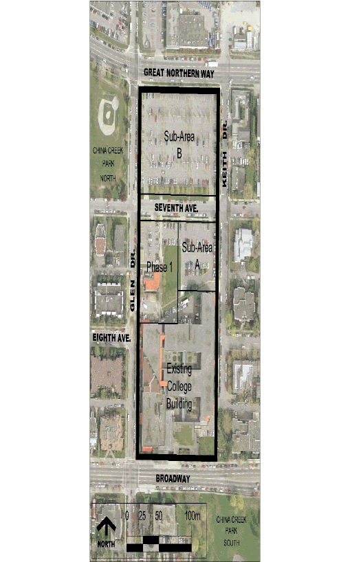
The following sets out principles for the timing of the delivery of key elements of the proposals in terms of facilities, infrastructure and public benefits. Reference should be made to Figure 4, which illustrates the various sub-areas within which new phases of development will take place.
The following should be delivered with Phase 1:
· Circulation
- `Central' section of the proposed north-south circulation `spine' linking existing building and 7th Avenue, including animating uses and links to Glen Drive.
- A prominent new entry to the `spine' from 7th Avenue to accommodate at grade pedestrian access from the new Skytrain station.
- Enhancement of the north-south circulation `spine' within the existing building and improvement of its connection to Broadway.
· Broadway presence
- Introduction of measures to improve the campus presence on Broadway including entrance features, and enhancement of the Broadway plaza and below grade service yard visible from Broadway. These measures should be introduced in parallel with the development of the campus south of 7th Avenue, with improvements made commensurate to the level of new development undertaken.
· Daycare
- Provision of temporary facilities during Phase 1 construction.
- Re-provision of expanded daycare as a permanent facility within Phase 1 building that meets the demand for daycare as agreed to with City staff.
· Public realm
- Streetscape enhancements (e.g. surfacing, landscape, lighting etc) on 7th Avenue and Keith Drive to improve pedestrian connections to the new Skytrain station. 7th Avenue enhancements should be carried out in the context of a design strategy for the whole of 7th Avenue with subsequent elements completed as part of later phases.
- Streetscape enhancements (e.g. surfacing, lighting, landscape etc) on Glen Drive south of 7th Avenue.
- Inclusion of Public Art contribution based on preparation of a Public Art Plan.
The following should be delivered prior to completion of development within Sub-area A:
· Public realm
- Streetscape enhancements (e.g. surfacing, landscape, lighting etc) to the south side of 7th Avenue.
- Inclusion of Public Art contribution based on preparation of a Public Art Plan.
The following should be delivered prior to the completion of development within Sub-area B:
· Campus circulation
- `Northern' section of circulation spine between 7th Avenue and Great Northern Way, including animating uses and strong entrance(s) on Great Northern Way to the new Skytrain station.
· Public realm
- Streetscape enhancements (e.g. surfacing, landscape, lighting etc) on north side of 7th Avenue and on Great Northern Way.
- Streetscape enhancements (e.g. surfacing, lighting, landscape etc) on Glen Drive north of 7th Avenue.
- Traffic calming (non-diversionary) on 7th Avenue.
- Completion of Public Art contribution based on preparation of a Public Art Plan.
· Recreation
- Contribution to meeting recreational needs to be agreed to with City staff.
Figure 4: Phasing sub-area plan