|
CITY OF VANCOUVER ADMINISTRATIVE REPORT | |||
Date: |
June 22, 2004 | |||
Author: |
Trish French, Melina Scholefield, Frank Ducote, | |||
Phone No.: |
7041/7916/7795 | |||
RTS No.: |
04258 | |||
CC File No.: |
8011/5762 | |||
Meeting Date: |
July 6, 2004 | |||

TO: |
Standing Committee on Traffic and Transportation |
FROM: |
General Manager of Engineering Services and Director of City Plans |
SUBJECT: |
Kingsway and Knight Neighbourhood Centre Shopping Area: Public Realm and Pedestrian/Traffic Improvement Plan |
RECOMMENDATION
A. THAT Council endorse the Kingsway & Knight Neighbourhood Centre Shopping Area: Public Realm and Pedestrian/Traffic Improvement Plan in Appendix A, to guide design and installation of street improvements, traffic signals, landscaping, beautification, street furniture design and placement and other items.
B. THAT Council approve project funding of $2,705,000 to implement the main package of improvements described in this report; source of City funding to be $1,040,000 from Streets Basic Capital, and $325,000 from the proceeds of the sale of the lane at King Edward Village; and $268,055 from citywide DCL's. The remaining funds would be provided by the King Edward Village site developer as a condition of rezoning ($249,145) and Translink ($823,500 subject to approval).
C. THAT additional annual operating costs of $3,500 related to ongoing maintenance of the new traffic signals, signs and road markings; and $31,550 related to the maintenance of the median and other landscaping, be reflected in future Operating Budgets, subject to the 2005 budget review.
GENERAL MANAGER'S COMMENTS
The General Manager of Engineering Services and Community Services RECOMMEND approval of the foregoing.
COUNCIL POLICY
On May 27, 1997, Council approved the Vancouver Transportation Plan which included directions to:
- Develop pedestrian priority areas in Neighbourhood Centres identified through Community Visions
- Improve pedestrian facilities by increasing opportunities for crossing busy roads safely, and providing incentives for walking throughout the City and especially within residential neighbourhoods
- Develop a commuter bicycle facility along the Kingsway corridor
- Install bike racks on blocks of commercial frontage and at major bus stops
- Improve the safety, comfort and convenience of bus stops and boarding areas
On July 21, 1994 Council approved a resolution
THAT a curb lane width of 4.3 m for a moving lane and 4.0 m for a parking lane be established as the desirable standard, where practical, to facilitate the integration of bicycles along new arterial streets; FURTHER THAT where this width is not practical, a standard of 3.7 m be adopted.
In July 1998, Council approved the Kensington-Cedar Cottage Community Vision, which identified Kingsway on either side of Knight as a "major neighbourhood shopping area...and community heart" with a "high priority for a wide range of improvements, to make it into a special community place along Kingsway." Vision Directions called for greater pedestrian safety, comfort, and amenity. The area was also identified as a focus for new housing variety, such as rowhouses, 4 and 6-plexes, and duplexes.
In July 2002, Council approved the first Neighbourhood Centre Delivery Program to be undertaken in Kingsway and Knight area, to implement the KCC Vision Directions for both the shopping area improvements and the new housing.
SUMMARY
The adopted Kensington-Cedar Cottage Community Vision (1998) identifies the area around Kingsway and Knight as a key shopping area and a location for new housing types, i.e. a neighbourhood centre. Since early 2003, through the Neighbourhood Centre Delivery Program (NCDP), staff have been working with community members to develop plans and initiatives that will implement these Vision Directions.
This report focuses on proposals and an implementation plan for one of the key products of the Kingsway and Knight NCDP, the Public Realm and Pedestrian/Traffic Improvement Plan (PRPTIP) for the shopping area along Kingsway between Inverness and Perry, and on Knight, between 22nd and King Edward.
The Plan has evolved through an extensive internal and public consultation process, which included work by a Shopping Area Working Group composed of community volunteers. The process culminated in a newsletter/survey that described, illustrated, and sought response to the major proposals.
Recommendation A is to approve the Plan in Appendix A. This Plan provides direction for revised street geometrics and signals; streetscape elements, such as street trees, sidewalk paving, planting and treatments; street furniture placement, style and colour; street lights and poles; and public art.
The most significant proposed public realm improvement is to introduce a landscaped median in the centre of Kingsway, between Inverness and Dumfries, while also accommodating a future bicycle facility in a 4.0 m curb lane. This is greater than the City's 3.7 m minimum standard for a shared cub lane. Achieving this requires moving the curbs along 4 block faces back a small amount. Of the options considered, this proposal best meets the three broad objectives that arise from the Community Vision and Vancouver Transportation Plan: creating a special visual character; providing more greening, and providing for a future bicycle facility. (Two other options for Kingsway were presented and considered: one which does not include a median but allows for a 4.3 m. curb lane for cyclists and cars; and one which includes the median but does not allow for a future bike facility.)
Other major proposed improvements are the normalization of Clark at Kingsway, to shorten pedestrian crossings and create landscaped "mini-parks"; changes to the Dumfries/Kingsway/King Edward intersection to provide shorter, safer crossings for pedestrians and bikes, and provide more landscaping; and landscaped bulges at Inverness, Perry and E. 23rd Ave. at Knight to assist with pedestrian safety and greening.
Recommendation B is for approval of the necessary funding. The overall cost of the project is estimated at $2.70 million, of which $1.07 will come from Translink and the King Edward Village rezoning. Of the City's portion of funding, about $1.04 million is available from the 2003-04 Streets Basic Capital; $325,000 from the proceeds of the sale of the lane in King Edward Village rezoning site; and $268,055 from DCLs.
PURPOSE
The purpose of this report is to seek Council approval of a Public Realm and Pedestrian/Traffic Improvement Plan (PRPTIP) for the Kingsway and Knight Neighbourhood Centre, as well as for the necessary funding to implement the Plan.
BACKGROUND
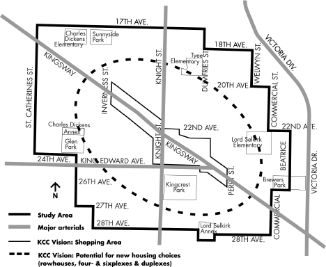
On July 4, 2002, Council approved the terms of reference for the first Neighbourhood Centre Delivery Program, in the Kingsway and Knight area. (Refer to Figure 1.) Products to be delivered from this program include:
· A Public Realm and Pedestrian/Traffic Improvements Plan, including: measures to upgrade the appearance, amenity, comfort and safety of the shopping areas (e.g. street furniture, bulges, medians, crossings, landscaping, and public art). This Plan is the subject of this report.
· Initiatives to enhance the viability of the shopping areas, including: retail/service strategy (completed), parking strategy (completed), assistance with business owner organization (ongoing).
· A Housing Area Plan, including: locations and types of new housing, as well as related measures dealing with traffic, parking, utilities, parks and greening, and city facilities. A report on this is being forwarded to Council at approximately the same time as this report.
Housing Zoning to be undertaken after approval of the Housing Area Plan, including: drafting, testing, and referral to Public Hearing of city-initiated area rezoning, and/or policies to guide future privately-initiated rezoning.
Figure 1: Kingsway and Knight Neighbourhood Centre Study Area
DISCUSSION
The Public Realm and Pedestrian Traffic Improvements Plan has been created to further a number of adopted policy objectives from the KCC Community Vision and Vancouver Transportation Plan including:
- creating a special community place;
- improving pedestrian safety, convenience and comfort;
- improving the shopping area's appearance;
- "greening" the street with landscape;
- providing for a future commuter bike facility along Kingsway.
Recommendation A is that Council approve the
Public Realm and Pedestrian/Traffic Improvements Plan (PRPTIP) in Appendix A. That Plan provides comprehensive guidance for improvements to be undertaken the public realm. Topics addressed in the Plan include:
· Revised street geometrics and signals
· Streetscape elements, such as street trees, sidewalk paving, planting and treatments.
· Street furniture placement, style and colour
· Street lights and pole colour
· Public art
The discussion below begins by outlining the public process that led to the development of the Plan. It then focuses on the most important improvements included in the Plan. Finally, total costs and funding sources are dealt with in the section on Financial Implications.
Public Process
The public kickoff "fair" for the Neighbourhood Centres program was held January 25, 2003. The event attracted approximately 250 residents and merchants from the area. Through this event and other outreach, staff recruited volunteers to form the Shopping Area Working Group (SAWG) including 4 merchants, 1 commercial property owner and 6 local residents. The task of the SAWG was to:
· Play a creative and critical role by assisting staff in generating, evaluating and narrowing the range of options for the plan;
· Advise staff on outreach, and ensure that as many people as possible in the area are involved or informed; and
· Assist in "watchdogging" the process to ensure it stays within the adopted Terms of Reference.
From February 2003 through to April 2004, staff held 9 working sessions with the SAWG. Activities included tours of the local shopping area and other comparable shopping areas, and "character preference" exercises. Staff also attended a number of meetings of the Cedar Cottage Business Association, to keep them informed of developments within the SAWG and seek feedback on the proposals being explored.
Options for the PRPTIP were developed through a combination of an internal staff design session, and ideas from the SAWG and business association. The options were refined in consultation with internal staff (including Planning, Engineering and Parks Board), the SAWG, the Cedar Cottage Business Association, and the Bicycle Advisory Committee.
In February 2004, a newsletter/survey was prepared describing specific proposals for the PRPTIP, with graphics and estimated costs. (It should be noted that subsequent refinement of design and costing has revised some of the costs.) The survey asked for preferences and opinions on funding priorities. About 3,200 newsletter/surveys were distributed to all households, commercial property owners, and merchants in the study area. All households received a full English and Chinese version of the survey. All commercial property owners and merchants received an English, Chinese, and Vietnamese version of the survey. The newsletter/survey was also posted on the web, with on-line response capability.
On February 12, 2004, staff held an open house to provide interested parties with an opportunity to ask questions about the proposals and to provide input on the options put forward. The Open House was advertised via the newsletter/survey, large banners, and posters. Because Kingsway is designated for a bicycle facility in the 1997 Vancouver Transportation Plan, cyclists who may have an interest in the route were invited through the Vancouver Area Cycling Coalition and Better Environmentally Sound Transportation list-serves. About 120 people attended the open house.
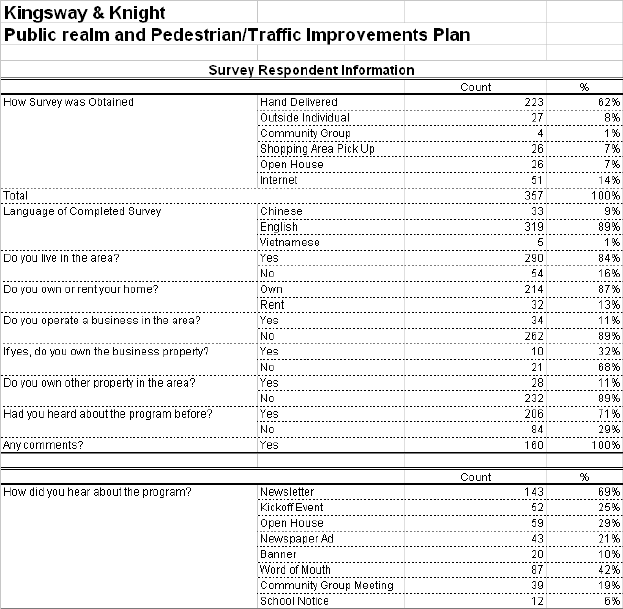
A total of 357 survey responses were received, which represents a return rate of approximately 11%. The return rate among local businesses was higher at 25%. This is a good response rate for a survey of this kind. The relevant survey results are referred to in the sections below discussing the proposed improvements. The full survey results are in
Appendix B.
Kingsway Improvements
Kingsway is a unique street in Vancouver, having been cut through the bush along an aboriginal trail in 1861 by the Royal Engineers, long before the City was incorporated in 1886. Its diagonal path makes it distinctive in the city grid.
In this shopping area Kingsway has a 30.5 m (100 ft.) right of way, with curb-to-curb width of 21.3 m. (70 ft. ) and 6 traffic lanes. Curbside parking is stripped in the peak direction during rush hours. Morning and evening 2 hour peak volumes are 5,000 to 6,000 vehicles respectively. This is among the five or six highest traffic volume local shopping areas in Vancouver. Local residents and merchants feel it has a "freeway-like" character at present.
Three cross-section options were developed for Kingsway, and included in the newsletter/survey. People were asked to rank their preferences. The options address the following policy objectives arising from the KCC Community Vision and the Vancouver Transportation Plan to varying degrees:
· Creating a special visual character
· Providing more greening; and
· Providing for a future bicycle facility.
All the options maintain the same number of traffic lanes and the same curbside parking.
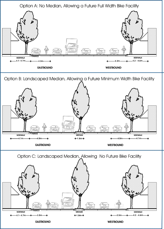
The options are described below and shown in Figure 2, followed by an evaluation of the public response, effects on street, trees and costs.
1. Options Description
(a) Option A: No median, allowing a future full width bike facility
This option optimises the future bike facility, but it does not contribute to the objectives of visual character or greening. The street would remain as it is now. There would be no median, which would allow a 4.3 m wide curb lane: the full City standard width for a shared cyclist/moving vehicle lane.
(b) Option B: Landscaped median, allowing a narrower width future bike facility
This option was designed to address all three policy objectives: visual character, greening, and provision for a future cycling facility. It provides a 1.8 m wide landscaped median and a 4.0 m wide curb lane. It requires moving the curbs in 4 block faces so that the total curb-to-curb width is widened by approximately 0.7 m, which still maintains desirable sidewalk widths (3.9 m to 4.3 m). In terms of the future bicycle facility, the curb lane would be wider than the City's minimum standard (3.7 m) for a lane shared by cyclists and moving vehicles, but not as wide as the full City standard for this situation (4.3 m). However, other than for peak traffic periods in peak directions (i.e. 2 ½ hours each way) parking is permitted, and the curb lane would meet the City standard for cyclists riding beside parked cars (4.0 m).
(c) Option C: Landscaped median, allowing no future bike facility
This option contributes to the objectives of visual character and greening, but does not allow for a future bike facility. It provides a 1.8 m landscaped median, and keeps the curbs where they are, allowing a 3.4 to 3.6 m curb lane. This option would require cyclists to share the existing curb lane with cars: motorists wanting to pass a cyclist would have to make a lane change, as now. If a bicycle facility is developed along the full length of Kingsway in future, these blocks would be an interruption in it.
Figure 2: Kingsway Cross-section Options
2. Options Evaluation
(a) Community Response
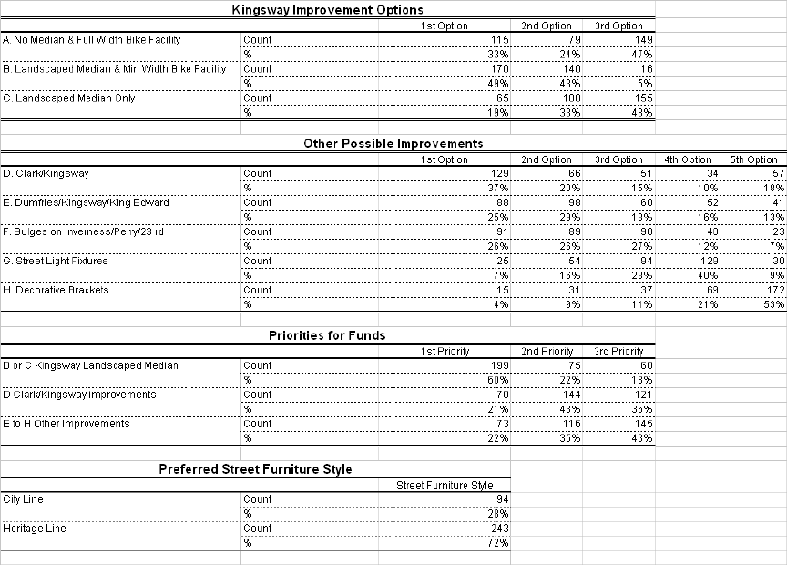
In terms of community support, Option B is the clear favourite: 49% picked it as most preferred, and 43% as second most preferred. The figures for Option A were 33% and 24%; and for Option C 19% and 33% respectively.
(b) Effects on Street Trees
There are currently 53 existing street trees in the area. Of these, 23 already require replacement due to roots that have damaged sidewalks. This would normally be done over time, as sidewalks are rebuilt.
Option A and C do not change the curb-to-curb road width, and therefore do not require removal and replacement of any additional street trees. Option B requires the removal of an additional 14 existing street trees. However, it should be noted that the overall Plan would result in a net gain of about 41 street trees, as well as 46 trees in the median, and 12 additional new trees in other the landscaped areas described below.
(c) Costs
Option A's cost would be limited to the $290,000 required to reconstruct four block faces of badly heaved sidewalks. This cost would be incurred by the City at some time, in any case. Option B costs approximately $592,000 for the landscaped median, plus $1.263 million to move the curbs, reconstruct the curb lanes, and reconstruct the damaged sidewalks in four block faces. The cost for Option C is $592,000 for the median, and $200,000 to reconstruct the damaged sidewalks: curb moving is not necessary. The City will be able to cost share both the median and curb/sidewalk reconstruction (see Financial Implications section below for details).
The cost of installing a landscaped median on Kingsway is higher than on most arterials, reflecting the fact that the original trolley line sub-base still runs down the middle of street, and must be dug out where the median will go. The cost of relocating the four block faces of curbs and rebuilding the curb lane in Option B reflects the fact that when installed, the existing curb lane base was constructed of concrete, most likely to cover inferior existing fill material. It should be noted that at some point in future the City would have to do this reconstruction work in any case.
(d) Recommended Option
The Bicycle Advisory Committee prefers Option A because it provides the highest standard for cyclists. Park Board staff would prefer options that minimize tree removal, but acknowledge that in order to meet all of the long term civic objectives some additional tree removal may be necessary.
While taking these views into consideration, Planning and Engineering staff feel that Option B best satisfies all three of the City's adopted policy objectives: enhanced visual character, greening, and future bike facility. It is also the option that is strongly preferred by the community. The recommended Plan therefore reflects Option B.
Other Improvements
The following major improvement elements were described in the newsletter/survey and are included in the PRPTIP. Respondents were asked to rank the priority of projects in their opinion.
1. Clark/Kingsway Normalization and Mini-parks
This proposal realigns Clark Drive to intersect Kingsway at right angles. It substantially reduces pedestrian crossing distances, and allows landscaped "mini-parks" to be located on the northeast and southwest corners. In addition to reducing both the distance and time for pedestrians to cross Kingsway, the coordination between the traffic signals on Kingsway at Knight and Clark is improved and should help ease congestion at Kingsway and Knight. The cost, including curb realignment, landscaping, signal moving and cyclist push-button is estimated at $378,000. This proposal was ranked first by 37% of respondents.
2. Dumfries/Kingsway/King Edward Crosswalk Relocation, Median, and Greening
This proposal relocates the pedestrian crossing of Kingsway and King Edward to Dumfries, shortening it and adding a new pedestrian/cyclist-activated signal. A landscaped median is added on King Edward, providing a refuge for pedestrians and cyclists at the intersection. The proposal also adjusts the south-east corner of the intersection, reducing pedestrian crossing distance across King Edward, slowing right-turning vehicles, and improving driver sight-lines of both oncoming traffic and crossing pedestrians. The cost, including curb realignment, median, signal, and landscaping is estimated at $178,600. This proposal was ranked first by 26% of respondents.
3. Landscaped Bulges on Inverness, Perry, and E. 23rd
Landscaped corner bulges would be added at these three locations to reduce pedestrian crossing distances, improve the visibility of pedestrians by motorists, prevent illegal parking too close to the intersection and for landscaping. The cost is estimated at $92,000. This proposal was ranked first by 25% of respondents.
4. New Street Light Fixtures
This proposal is to retrofit the existing 60 cobra head street light heads with substantial luminaires that would be both decorative and reduce night sky glare. These are distinctive compared to the lights used along the rest of Kingsway, and will help add definition and character to the area. The estimated cost is $112,000. This proposal was ranked first by 7% of respondents.
(A proposal was also put forward to install historic light brackets at the pedestrian level on existing light poles. At present they would be decorative only, i.e. without light fixtures, although in future the commercial property owners could fund the lighting if they wished. This proposal was only supported by 4% of respondents, and is not included in the Plan.)
FINANCIAL IMPLICATIONS
Table 1 shows the costs of various elements of the Plan, together with how the costs will be shared among the City, Translink, and the King Edward Village project (through conditions on the approved rezoning). Table 2 shows the funding sources for the City's portion of the costs.
Table 1: Costs and Cost Sharing
Cost ($) |
Cost Sharing ($) | ||||
City |
Translink |
K. Edward Village | |||
1 |
Kingsway Median & Curbs/Sidewalks |
1,855,300 |
1,170,455 |
596,000 |
88,845 |
2 |
Kingsway & Clark Imps |
378,000 |
211,500 |
166,500 |
0 |
3 |
Kingsway/King Ed/Dumfries Imps |
178,600 |
28,800 |
60,500 |
89,300 |
4a |
Inverness Bulges |
35,000 |
35,000 |
0 |
0 |
4b |
Perry Bulges |
35,000 |
35,000 |
0 |
0 |
4c |
23rd/Knight Bulge |
22,000 |
11,000 |
0 |
11,000 |
5 |
Dumfries Triangle Imps |
29,300 |
29,300 |
0 |
0 |
6 |
King Ed Village Related |
60,000 |
0 |
0 |
60,000 |
7 |
Kingsway Decorative Light Fixtures |
112,000 |
112,000 |
0 |
0 |
TOTAL |
2,705,200 |
1,633,055 |
823,500 |
249,145 | |
Table 2: City Funding Sources
2003-04 Streets Basic Capital |
1,040,000 * |
Proceeds from sale of Lane at King Edward Village |
325,000 |
Development Cost Levies |
268,055 |
TOTAL |
1,633,055 |
*includes: