|
CITY OF VANCOUVER ADMINISTRATIVE REPORT |

Date: |
February 23, 2004 | |
Author: |
Fred Lin | |
Phone No.: |
604-873-7693 | |
RTS No.: |
03820 | |
CC File No.: |
5757/8019 | |
Meeting Date: |
April 6, 2004 |
TO: |
Standing Committee on Transportation and Traffic |
FROM: |
General Manager of Engineering Services |
SUBJECT: |
Collingwood Village Neighbourhood Traffic Plan |
RECOMMENDATION
A. THAT Council approve the Collingwood Village Neighbourhood Traffic Plan as described in this report, to be funded by the contribution from Concert Properties Ltd. for an amount of $102,150, with an additional $147,850 from the Streets Capital Account 30006364- Collingwood Village Traffic Measures.
B. THAT the one-way southbound measure on Tyne St., between Archimedes St. and Kingsway, be installed on a trial basis for a period of no less than six months.
C. THAT following the trial period, traffic counts be taken as well as a follow-up survey with the affected residents to determine whether the trial one-way measure will be installed on a permanent basis.
D. THAT the Traffic Operating Budget for Signage be increased by $2,000, without offset and subject to 2005 Budget Review, for the maintenance of the new traffic measures, commencing in 2005.
COUNCIL POLICY
· In May 1997, Council approved the Vancouver Transportation Plan that emphasizes the need to mitigate the effects of traffic in local neighbourhood areas and to give priority to streets and neighbourhoods where traffic impacts are most serious.
· It is Council policy to implement diversionary traffic calming measures on a trial basis, with a follow-up survey, before making the measures permanent.
· In 1993, as part of the rezoning of the Joyce/Vanness Industrial Area, Council instructed that a neighbourhood traffic plan be developed for the Joyce Station Area, prior to Phase IV development.
PURPOSE
The purpose of this report is to seek Council's approval and funding to implement the Collingwood Village Neighbourhood Traffic Plan, as described in this report.
BACKGROUND
In 1993, Council approved the rezoning of the Joyce/Vanness Industrial Area to allow for a high-density residential community (Collingwood Village). As a condition of approval, Council requested that prior to Phase IV development proceeding, traffic impacts from the earlier phases be studied and a mitigation plan be undertaken at the cost of the developer. The focus was to be on the portion of the Joyce Station Area located generally to the south of the Collingwood Village.
In early 2003, the project proponent (Concert Properties Ltd.) for Collingwood Village undertook a traffic impact study, as part of the prerequisites to the last phase of the development. The study was conducted to (i) assess the impacts of the development on the existing neighbourhood to the south and (ii) identify mitigation measures to alleviate the impacts. The results of the study were subsequently presented to the area residents in an open house held on March 26th, 2003. In that open house, residents had an opportunity to express their opinions about the findings and mitigation measures identified in the traffic impact study, and to bring forward any additional traffic concerns they have that were not identified in the study. The study results and residents' inputs provided a good basis for the proposed neighbourhood traffic plan.
Following the open house, a resident working group was formed to work with City staff on designing a traffic plan for the neighbourhood. After a series of meetings, a draft plan was developed to (i) ameliorate the impacts of the development on the neighbourhood and (ii) address residents' concerns about the existing traffic conditions on their streets.
TRAFFIC PLAN ELEMENTS
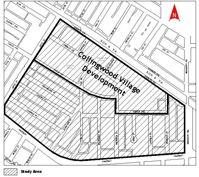
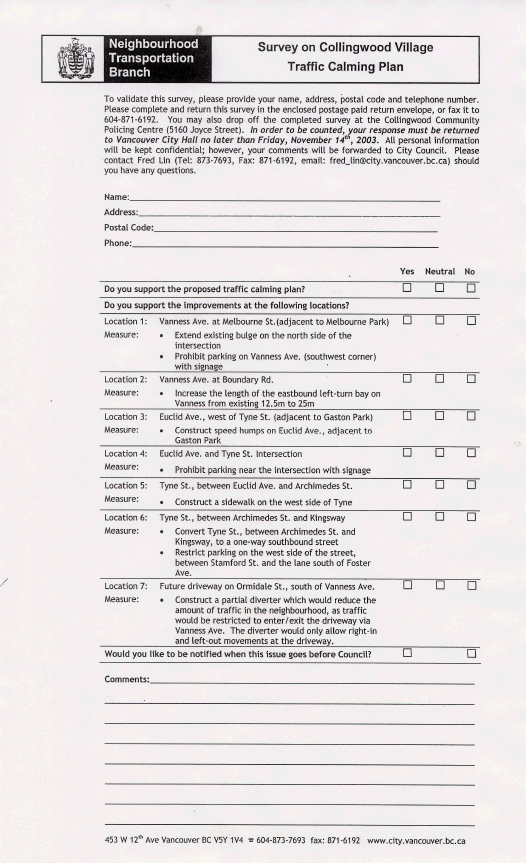
For the purposes of developing the traffic plan, the Collingwood Village neighbourhood is defined to be bounded by Joyce St. to the west, Boundary Rd. to the east, Vanness Ave. to the north, and Kingsway to the south. See Appendix A for the map of the study area.
The proposed plan includes measures at seven principal locations intended to deal with various traffic- and pedestrian-related issues. The following provides, at each location, a description of the proposed improvements and the issues they intend to address. See Figure 1 for the schematic illustration of the plan.
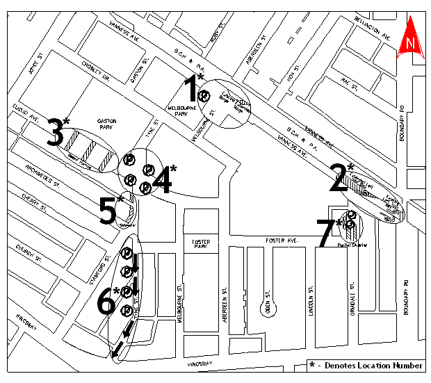 Figure 1. Proposed Neighbourhood Traffic Plan
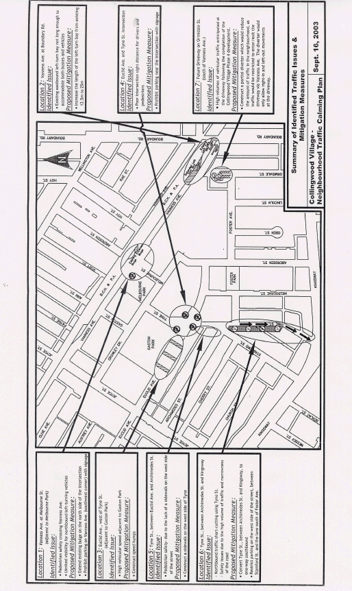
Location 1: Vanness Ave. / Melbourne St. Intersection
At this location, the sight distance available to pedestrians (southbound) and drivers (northbound left-turning) crossing Vanness Ave. was found to be insufficient. To address these issues, it is proposed that the corner clearance on the southwest corner be increased and the existing mid-block bulge on the north side of Vanness Ave. be extended.
Location 2: Vanness Ave. / Boundary Rd. Intersection
The eastbound approach of this intersection consists of a shared through/right-turn lane and an exclusive left-turn lane measured to be approximately 12.5 m in length. It has been determined that the length of the left-turn bay is not sufficient to accommodate the amount of traffic that currently turns at this location, which has resulted in conflicts between the queued left-turn vehicles and the through/right turn vehicles in the curb lane. This queue is expected to lengthen to approximately 25 m upon the completion of the Collingwood Village development. It is therefore proposed that the left-turn storage bay be lengthened to at least 25 m to meet the future demand and to reduce the potential for conflicts.
Location 3: 3400 Block of Euclid Ave. (adjacent to Gaston Park)
Speed humps are recommended at this location. The humps would reduce the high vehicle speeds recorded on the street (50km/h), which is located adjacent to Gaston Park and has a posted speed limit of 30km/h.
Location 4: Euclid Ave. / Tyne St. Intersection
The intersection sight distance is found to be insufficient for drivers and pedestrians crossing Euclid Ave. To address this issue, it is proposed that corner clearance be increased on all legs of the intersection.
Location 5: Tyne St., between Euclid Ave. and Archimedes St.
Pedestrian safety is a main concern at this location. Currently, no sidewalk is provided along the west side of Tyne St., between Euclid Ave. and Archimedes St. To stay on the sidewalk, pedestrians walking to and from Kingsway are required to cross to the east side of Tyne St. at Euclid Ave. and then cross back to the west side of Stamford St. at Archimedes St. This has resulted in unsafe conditions as many pedestrians follow the shortest distance and walk on the west side of the roadway on Tyne St., with their backs facing the traffic. To address this issue, a pedestrian sidewalk is proposed along the west side of Tyne St., between Euclid Ave. and Archimedes St.
Location 6: Tyne St., between Archimedes St. and Kingsway
This section of Tyne St. has been identified as a shortcutting route. The street is a local residential street that carries more than 3,000 vehicles per day, which is significantly greater than the 1,000 vehicles per day typical on other residential streets in the city. The high volume likely stems from the fact that the signal at Kingsway facilitates non-local vehicles short-cutting using Tyne St. The high volume, combined with a relatively narrow street allowance, has resulted in safety issues and complaints from the public. To address these issues, it is proposed that Tyne St. be converted to a one-way southbound street and the on-street parking be restricted on the west side of the street, between Stamford St. and the lane south of Foster Ave. These improvements are expected to reduce the amount of short-cutting traffic in the neighbourhood and at the same time, reduce the potential of conflicts, especially in the sections with a narrow street allowance.
The one-way measure on Tyne St. is diversionary and would be installed first on a trial basis for a period of no less than six months. Following the trial implementation, traffic would be monitored on adjacent local residential streets to ensure an unacceptable level of traffic diversion does not occur. Staff will then consult with the affected residents and report back to Council as to whether the measures should be made permanent.
Location 7: Future Driveway on Ormidale St., between Foster Ave. and Vanness Ave.
It is anticipated that upon the completion of the Collingwood Village development, the amount of traffic on Ormidale St. and Foster Ave. would increase to more than 2,000 and 2,500 vehicles per day, respectively. As indicated previously, this amount of traffic would be higher than the amount of traffic volume typical on other residential streets in the city. To reduce the amount of traffic (generated from the development) on these streets, it is proposed that a partial diverter be installed at the future driveway on Ormidale St., between Foster Ave. and Vanness Ave. The diverter would reduce the amount of traffic in the neighbourhood, as vehicles would be limited to accessing the driveway using Ormidale St. directly to and from Vanness Ave. only.
NEIGHBOURHOOD CONSULTATION
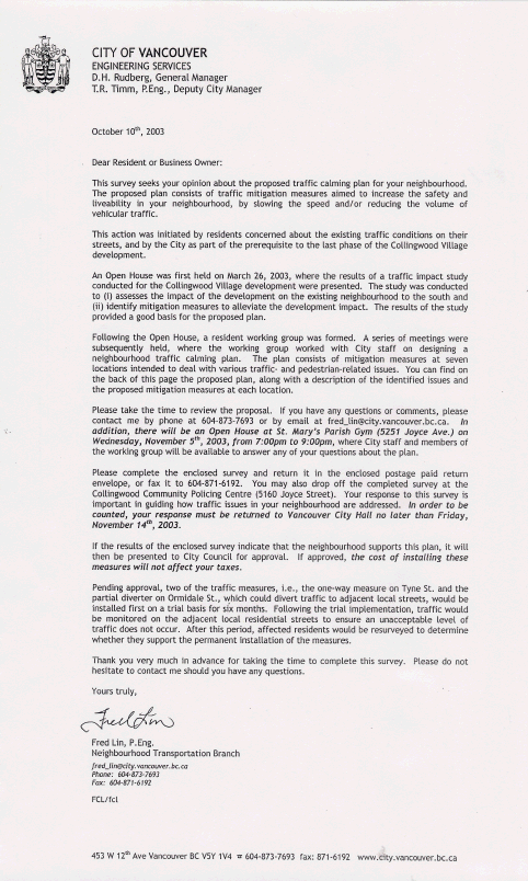
In October 2003, more than 2000 surveys were distributed to the neighbourhood residents to seek their opinions on the proposed traffic plan. See Appendix B for the survey sent out. Survey results and comments are included in Appendices C and D, respectively. The results of the survey show that the proposed traffic plan is well-supported (90% approval rate) by the neighbourhood residents. All of the proposed individual traffic measures received an approval rate of 75% or more, except for the partial diverter on Ormidale St. Specifically, a lower support rate (61%) is obtained for the diverter; however, 31% of the respondents are indifferent to the proposal. In general, comments received were very positive, with some requesting ongoing monitoring of traffic to ensure that no significant diversion of traffic does occur.
FINANCIAL IMPLICATIONS
The total cost to implement the Collingwood Village Neighbourhood Traffic Plan is estimated to be $250,000, with an amount of $102,150 to be funded by the contribution from Concert Properties Ltd. and the remaining $147,850 from the Streets Capital Account 30006364- Collingwood Village Traffic Measures. There should also be an increase to the Traffic Operating Budget for Signage by $2,000, without offset and subject to 2005 Budget Review, for the maintenance of the new traffic measures, commencing in 2005.
CONCLUSION
It is recommended that Council approve the Collingwood Village Neighbourhood Traffic Plan as described in this report, based on the overall benefits to the neighbourhood and the strong support from the affected neighbourhood residents.
- - - - -
APPENDIX A
STUDY AREA
APPENDIX B
ENGINEERING SURVEY
APPENDIX C
SUMMARY OF SURVEY RESULTS
Location and Traffic Measure |
Approval Rate |
Disapproval Rate |
Neutral |
|
Overall Traffic Plan |
90% |
2% |
8% |
Location 1: Vanness/Melbourne
|
86% |
5% |
9% |
Location 2: Vanness/Boundary
|
86% |
1% |
13% |
Location 3: 3400 Block of Euclid
|
79% |
8% |
13% |
Location 4: Euclid/Tyne
|
90% |
4% |
6% |
Location 5: Tyne, between Euclid and Archimedes
|
87% |
2% |
11% |
Location 6: Tyne, between Archimedes and Kingsway
|
75% |
11% |
14% |
Location 7: Future Driveway on Ormidale, between Foster and Vanness · Construct a partial diverter at the future driveway location on Ormidale |
61% |
8% |
31% |
APPENDIX D
SURVEY COMMENTS
Approval:
· Please also consider putting a traffic calmer on the corner of Aberdeen and Foster (adjacent to the small park) as a lot of southbound cars on Aberdeen are speeding. This is a serious concern for me as speeding cars/drivers pose danger on children playing in the park and people crossing the street.
· I want more safety at the corner of Tyne and Archimedes because it is a 4-way intersection. Cars always come running on Tyne with a great high speed and kids are playing in the two adjacent parks. My house on Archimedes was hit 3 times with speeding cars. One time, a car came into my yard. Please hurry, do something! Very dangerous!
· Traffic on Joyce is very heavy- what about plans to reduce the amount of traffic on Joyce?
· Great plan. Thanks. For Location 4, would a full stop intersection be helpful to reduce the speed for location 3 and for drivers and pedestrians at the intersection?
· Future "high density" residential development should be put on hold pending local traffic improvements, and the support of community services. Row houses preferred than more high-rise buildings in the area. Single houses are even more preferred.
· Is there any more information available on the City of Vancouver's website? Please email me.
· I wholeheartedly approve of well-planned traffic calming measures. They improve safety and livability of the neighbourhood at minimal financial costs. My only concern is with location 2 that it would facilitate (and increase) vehicle traffic cutting through the neighbourhood on Vanness, with no benefit to pedestrians, cyclists or transit.
· 1) Euclid and Tyne should be made to a four-way stop intersection. 2) Stamford from Kingsway north to Archimedes should be one way going north. 3) Church should be one way going east or blocked off at Joyce and Church. 4) Church needs residential parking signs to stop parking from businesses on Kingsway. 5) We requested a wheelchair cut out on the two sidewalks (north side) of Church on the lane behind Joyce (east), could these be done while they are working on Joyce? Please reply to my email.
· I'm concerned that changes proposed at location 6 might further increase traffic on Church. Also, I hope you will consider reducing the already heavy traffic on Church, with a number of speed bumps, lane narrowing, and resident-only parking measures. Ditto for the Kingsway/Church alley. Eliminating parking in front of the Subway store on Vanness at Crowley before a pedestrian is killed by someone turning east off Joyce as parked vehicles obscure vision there.
· Traffic changes will go a long way to making this a safer neighbourhood.
· There is no provision being made for speed hump for Crowley & Gaston Park. This also is a speedway. No provision for Gaston & Crowley for stop signs - very dangerous southeast corner. At Gaston and Vanness, it is impossible to see any oncoming traffic until you are in the centre of the road with the way parking is now right to the corner.
· Do what you can to keep the traffic out of residential streets. There is too much commercial traffic on Joyce Street, with heavy trucks going all night.
· Speed bumps would also be useful on Crowley between Tyne & Joyce, specifically along Gaston Park where the children's playground is located. Speeding vehicles are an issue even with the posted playground zone speed limits.
· Construct speed humps on Crowley Drive.
· At location 4, could you consider posting 4-way stop signage for drivers and pedestrians? Crosswalk markings should be installed in addition to the proposed parking restriction near the intersection.
· Thank you.
· Location 4: Would like to see a 4-way stop not the existing 2-way.
· Grass cutting at Gaston Park: Please don't do it early in the morning.
· No comments.
· With Collingwood Village developing, more and more people have already moved into the neighbourhood and will continue to do so. New traffic construction is not enough for safety. Every morning, there are many people (including children) walk cross Tyne, Crowley and Vanness to the Skytrain station for work or for school. But the existing traffic conditions are not satisfactory and even dangerous. I strongly support the plan.
· I'm not often a pedestrian but from a motorist point of view, location 4 is for sure the most dangerous spot in our neighbourhood and should be dealt with as soon as possible.
· Restrict parking on roadway (Vanness) for added pedestrian safety to access the building.
· Location 1: Install a crosswalk on the east side at the Vanness/Melbourne intersection. Location 4: Better make it a 4-way stop intersection. Location 6: If Tyne is converted to a one-way street, there is no need to restrict parking on either side.
· Location 3: instead of constructing speed bumps, why not put a 4-way stop at Euclid and Tyne? Then drivers will come to a complete stop then proceed again with caution.
· As a pedestrian, I have had numerous close calls with left turn autos. How about no left turns at busy intersections? Drivers seem to be too busy watching oncoming traffic to even bother with pedestrians in the crosswalk.
· Better alternative for location 4 is a 4-way stop.
· Permit parking between Tyne and Melbourne has assured us permanent parking for our wheelchair vehicle. Thank you so much.
· Would it be possible for the landscaping crew working at Gaston Park not to commence their work so early in the morning? It disturbs a lot of people still sleeping in the vicinity? Thank you.
· About location 6 - I propose that Tyne between Archimedes and Kingsway stay open as a two way street and make it a No Parking street. Also paint white, broken dividing lines on pavement. Residents living there should use their garage to park their cars. Also do not proceed with the Collingwood Development, use that space for parks. Thank you.
· Every intersection including quiet street or avenue should have a stop sign or 4-ways stop sign.
· Can a left turn signal be added on Boundary and Vanness for left turn from Kingsway to Vanness? It always takes me minutes waiting for the turn. That will also reduce the traffic at 41st and Kingsway. Call me if there is any misunderstanding please.
· If it needs to be done, I would suggest having the new type of (broader and shallower) humps, rather than the old fashion narrow and abrupt type which is very harmful to vehicles.
· 1) On crossroads between Tyne & Crowley, limited visibility for eastbound and westbound left turning vehicles. I would suggest posting 3-way signage. 2) Location 4 would be safer with a 4-way stop control. 3) Tyne, between Euclid and Crowley, has many cars parked on both sides of the street, which makes visibility very poor. The bend of the road makes it worse. Two speed bumps before and after the bend may make it safer.
· I would like to see a traffic light installed at the intersection of Euclid and Tyne.
· Restricting Tyne to one way is not a good idea as the traffic light on Tyne and Kingsway makes it a vital road up and down from the shopping area. I think restricting parking would be sufficient.
· A nice and quiet area makes all the difference in living. This is what we have been waiting so we do look forward to the good news in the near future.
· We need a 4-way stop sign on Tyne at Euclid. There is a 2-way stop sign on Euclid but it would be much safer if it is upgraded to a 4-way stop sign. The neighbourhood gets busier and busier with increasing traffic and new housing development. That intersection is too wide and ineffective with only a 2-way stop sign. Plus the streets at that intersection are on a slight slope.
· These proposals really help everybody towards improving the safety on the road. Excellent. Keep it up.
· If this plan does not happen, I'm not sure if I'm available to attend future meetings because I do shift work. Thanks.
· Visibility coming out of Gaston - northbound onto Vanness is very poor, due to the parked vehicles. I would like to see parking restrictions at this junction also.
· Go ahead.
· Suggest a 4-way stop at location 4.
· From Gaston to Vanness, making either right or left turns is very danger because the poor visibility. There are so many vehicles parking too close to the T-intersection. I hope that the City would do something about it.
· Suggestion: Install left turn signal for northbound traffic on Boundary at Vanness.
· I still think speed humps are the best means to control speed. As I walk across the street from Euclid to Tyne, Gaston and Crowley, and Vanness at Melbourne, you see drivers drive very fast on the street. Sometimes I screamed at the drivers to slow them down because they are driving as if they were on a highway.
· Installing speed bumps on Euclid (location 3) is a very good idea. Safety of children living in the area would increase.
· I get around in an electric wheelchair. I shop at Safeway, London Drugs and other stores on Kingsway. I travel up the hill on Melbourne or Tyne. The biggest problem that I encounter is that the power poles, light poles and telephone poles located inside the walkway of the sidewalks. The amount of clearance for my wheelchair is minimal. Could the worst of these poles be moved or the sidewalk be widened to allow for more clearance?
· I support the proposed traffic calming plan 100% especially the measures proposed at location 3 (to construct speed humps on Euclid). I live in front of the Gaston Park and cars are speeding so much. I am concerned not only for my kids but for all pedestrians. One more concern is that it's hard to park in front of my house even I have my parking permit. Only 2 permits are allowed for every household but some houses have 3 or 4 cars, and not all of them have permits. Sometimes I have to park my car 8 houses away from my house because it is so full and I have to carry my kids and 18L bottled water at the same time. Only 2 hours of parking are allowed but people park 3 or more hours. I don't know if we can solve this matter? Thanks for looking into it.
· I think these new ideas are great.
· Good idea if you construct speed humps on Euclid adjacent to Gaston Park. People tend to drive very fast on the street. People ignore the speed limit sign, drive as fast as 60-70km/h. Please do something!
· Euclid and Tyne could use a four way stop.
· I think in addition to installing speed bumps on Euclid Ave. adjacent to Gaston Park, they should also be installed on Euclid Ave. between Tyne and Aberdeen. I have been waken up many times in the middle of the night by cars that come down along Melbourne and then take Euclid westbound at a very high speed. Please let me know what you think about this suggestion!!!
· I would like to propose that location 6 on Tyne between Archimedes and Kingsway, parking be restricted on both sides of the street because of the narrowness of the road. The corner street of Tyne and Foster should be fixed.
· Yes to question 1. No from 2 to 6. Should also consider paving the back lane between Euclid and Archimedes between Joyce and Tyne. Lights in the back lane between Archimedes and Joyce would be a good improvement as well.
· No one-way on Tyne. Yes to no parking on west side of Tyne. I live on Foster and I use Tyne to come home from Safeway as there is a traffic light.
· I have one comment about the intersection of Gaston & Vanness. It is very dangerous for cars coming out from Gaston and turning either right or left onto Vanness, due to the limited vision of oncoming cars. We should either extend the length of parking restriction on the southwest and southeast corners or not allow any parking at all.
· 1) Location 4: install a 4-way stop and move the 30 km/h park sign closer to the intersection. 2) Location 6: restrict parking on west side but keep the 2-way traffic. 3) Crowley Drive: a lot of speeding and drugs trafficking. Construct 3 speed bumps on Crowley, i.e. one between Tyne and Melbourne, one between Tyne and Gaston, and one between Joyce and Gaston.
· 1) Straighten Tyne out, remove hydro pole on east side Tyne. 2) Put 4-way stop signs at Tyne and Euclid, as cars on Tyne heading south have very poor visibility of the Euclid traffic.
· Location 6: Tyne between Archimedes and Kingsway - also prohibit parking on the east side of Tyne between Archimedes and Kingsway to make it wide enough for both directions of traffic rather than the one-way proposal.
· We really recommend the construction of speed bumps on Vanness, all the way between Joyce and Boundary. This is badly needed due to the increases in traffic volumes and vehicle speeds, on top of many pedestrians crossing the street. We also recommend a bus stop on the east corner of Gaston at Vanness (eastbound), due to the irresponsible drivers who park very close to the corner and block the view of cars and pedestrians coming from south of Gaston (this is very dangerous and it very collision prone).
· Locations 3, 4 and 5- 4-way stop are better than speed hump. Location 6- I would suggest not to make a one-way street. It will not be convenient for me to go back home when I shop on Kingsway. Location 3- Speed humps do not look nice on city streets.
· We don't have enough information to comment on Location 7. Locations 4 and 6 should be top priority. Both of them pose serious problems. Northbound traffic turning west off Gaston at Vanness faces the same problem as at Location 1. The biggest problem in our neighbourhood is the poor diver visibility caused by people disobeying the no parking signs and doing double parking, etc. Parking laws must be enforced.
· Thank you and good luck with the surveys.
· If you are going to construct speed humps on Euclid, why not include Crowley? I've been living here for 7 years and I think the worse area that people don't care about the park speed limit is at Crowley. This is especially true in summer when they show off their expensive sports car to young women hanging out at the basketball court. My son was almost run over there. My wife and I are scared to cross on the street. Thank you.
· Please consider putting speed bumps on Crowley and Gaston as many drivers drive around with park at a very high speed. There are many kids play in Gaston Park, especially in summer.
· I would like to see speed humps along Vanness between Joyce and Boundary. People are continuously speeding down Vanness. It is a very dangerous road for pedestrians. I am a victim of a near miss by a car speeding down Vanness. What will it take to get speed humps? A death?
· I mostly agree with the traffic calming plan proposed for Collingwood. I would like to suggest a new plan for making Kingsway (from Joyce to Tyne) more pedestrian friendly. This could be done easily by installing metal or wood chairs and benches even providing for a new crosswalk at Safeway.
· Location 6: allow two-way traffic to the laneway off Tyne and one-way from Archimedes to the laneway. Business utilizes the laneway for customer parking and for rear access. The proposal will severely impact customer flow and business flow.
· Location 4: 4-ways stop at Tyne and Euclid. Suggestion: speed bumps before and after Foster Park on Aberdeen.
· I have seen people driving more than 70km/h on Vanness, from Joyce to Boundary.
· I would like to see a 20km/h speed limit all around the high density areas, i.e., Tyne, Crowley, Melbourne and others. Every time my granddaughter and I try to cross Melbourne Street coming out of the Emerald Tower, we get run over by a car zooming around from Vanness to Melbourne.
· I am hoping the changes happen as soon as possible at location one because I have several close calls. There are so many vehicles parked on Vanness and blocking sight of traffic on Vanness when I turn left.
· My only concern is the proposed changes at location 6- would it increase traffic on Melbourne/Tyne/Stamford?
· Thank you for letting me respond to your survey. Yes, I agree with these traffic issues around in neighbourhood.
· Regarding location 6, if this proposal is accepted, would it mean that southbound traffic will start to use Melbourne or more likely Aberdeen as a southbound shortcut from Kingsway? Some of the side streets are necessary during heavy traffic time to relieve congestions on main roads such as Boundary, Kingsway and Joyce.
· These all sound like good ideas. Especially the improvements proposed at locations 1, 4 and 6. Those are dangerous spots in the neighbourhood right now.
· I'm not so sure that I understand what's been proposed at location 1. I'm very much interested in the overall traffic improvements and hope you'll do something. Everyday I turn left from Melbourne to Vanness and most of the time there's some car or truck that's obstructing the view of an oncoming vehicle. This could be fatal if a car accident were to happen.
· Speed humps are also needed on Tyne between Crowley and Euclid. This is next to the children's playground, with a bend, and limiting visibility. Parking should also be restricted to one side in this block. Thank you for acting quickly. Excellent!
· We have been waiting for something like the proposed changes for a long time. We are glad to have a say and hope that these changes go through for the safety of all the families who live in this beautiful and growing neighbourhood. Thank you.
· Excellent work! I was very happy to see this survey. Thanks for the work.
· Good initiatives.
· I would suggest that there should be underground parking for the high rise buildings on Euclid, Melbourne and Vanness. Alley connecting Melbourne and Tyne Streets should be paved smoothly. People use this as shortcut and there is a lot of traffic. This alley is in a really bad shape and it is hard for disabled people to walk.
· Location 4: Why not make the intersection 4-way stop? Location 6: Many vehicles were parked in the "No-waiting Zone" on Tyne at the northwest corner of Kingsway, beside Starbucks, which always block the traffic at the traffic light. I hope you will solve this problem.
· Proposed parking restriction in front of the hydro pole (in front building) in case of a fire. Now only limited to two hour parking on weekdays and Saturdays and people with parking permits.
· I think the proposed improvements would definitely increase the safety of both pedestrians and drivers. I would like to suggest that a 4-way stop at the Euclid and Tyne intersection be installed. The angle at which the streets intersect makes it difficult to see traffic. For example, when traveling southbound on Tyne, it is very difficult to see Euclid traffic. I would like to suggest making improvements for people crossing to and from the Skytrain on the east side of Joyce. Thank you for looking into this.
· Location 4 could have stop signs on all approaches and making all vehicles stop. This would slow down the traffic on Euclid. Location 6 should stay two-way and no parking and take the grass out at the bottom. If it goes one-way we would have to use Kingsway and make a left hand turn at our streets. This makes it more dangerous and also makes Kingsway busier.
· Why is the permit parking on Ormidale not free? I have to pay for a permit so that I can park on my street (and I will never get another permit). 90% of the cars parked on Ormidale have no permit. When I phone, sometimes traffic enforcement comes around 2PM (too late) but Telus quits at 4. What we need is to have the street checked once or twice a week and do it between 9-11AM. Thank you.
· One-way northbound on Tyne all the way from Kingsway to Crowley and Melbourne and Aberdeen one-way southbound with light on Kingsway to allow access to Kingsway. Location 4 is a very dangerous intersection especially when foggy.
· In my opinion, the proposed plan is well designed. The only addition I could think of is adding a left turn light for the traffic going northbound on Tyne when crossing Kingsway. If Tyne becomes a one-way street, more vehicles will be turning left on Kingsway to use Stanford and it would be good to accommodate this increase. Also, a left turn light from Boundary to Vanness is necessary.
· Location 4: Due to the poor visibility at the intersection, 4-way stop signs are necessary, combined with parking prohibition, near the subject location. Thank you!
· Location 4: Put 4-way stop sign rather then prohibiting parking.
· The corner where the back lane meets Tyne is a problem as people or cars getting out can not see the traffic, but the one-way operation will help.
· During morning rush hour, a lot of drivers rush through red light at the intersection of Tyne and Kingsway (westbound). Some drivers pull their cars up too much on Kingsway to turn left to Tyne. Too many cars stop and park at the no stopping zone adjacent to Starbuck coffee in the morning. Thanks.
· Location 4- Euclid and Tyne intersection should have a 4 way stop sign. Location 3- speed humps would also be good along Tyne (between Euclid and Crowley) and along Crowley (the other side of Gaston Park). There are a lot of young drivers speeding along this area.
· Where pedestrian crossing safety is involved (Locations 1 and 4), crosswalks should be considered. Also, the intersection of Tyne and Euclid is irregular shaped - a traffic circle would help slow down the traffic and ensure safe passage of vehicles.
· Stop trucks from using the lane behind Kingsway and 5240 Tyne as a turn-around. They are too big to navigate the lane safely.
· Location 6: These should be surveyed as separate issues. I do not support making Tyne southbound only but I do support restricting parking on one side of the street.
· We are glad that measures have been taken to make our streets safer. We are concerned about the volume of traffic and the narrowness of Tyne and some without sidewalks. Please keep us informed. Thank you.
· I wish that location 6 gets approved as we seen way too many accidents and speeding cars going southbound and northbound. It's a matter of time before there is an accident.
· At the intersection of Joyce and Vanness, there should be left-turn only signals for traffic on Joyce.
· It is very hard to see traffic when coming out of the parking lot to turn on Vanness.
· It would be nice if some traffic calming circles or speed bumps could be installed along Crowley, adjacent to Gaston Park. Cars also tend to speed through this stretch. Don't want see location 6 turn into a one-way street (southbound only). It is a convenient route to access Safeway.
· Enforce speed limit on Vanness from Joyce to Boundary and Joyce to Rupert. Enforce the 24-hour no parking in the lane from Crowley to Vanness.
· I have seen a lot of cars speeding on Vanness and Melbourne. Maybe it's time to enforce the law to stop people from speeding and to prevent pedestrians from getting hit. More officers are needed to patrol around this neighbourhood. I am sure that pedestrians will appreciate added safety on the roads.
· Thank you for taking this initiative. Changes do need to be made due to volume of vehicles in the area.
· Location 1: This item should be dealt with first as there are many near accidents at this location everyday because of the large vehicles blocking view of drivers turning left.
· Location 4: Alternatively, make it a 4-way stop intersection. Location 1: Alternatively can be made a 3-way stop intersection.
· Thanks!
· Too many commuters are using these streets as a shortcut, for what? Just to shave off a few minutes. Please do something soon or something tragic might happen.
· The section of Vanness between Joyce and Boundary needs some kind of speed control, i.e., speed bumps perhaps. I have been living on Vanness for 5 years. I've seen enough people speeding up and down Vanness. Something needs to be done, especially when you consider the number of elderly and youngsters living in this area.
Disapproval:
· More discussion with local residents is required.
· Location 6: I feel parking restriction is all that's required. Location 3: Vehicle speed/volume does not seem unsafe. Speed bumps would be a waste of time and money.
Neutral or No Preference Indicated:
· Location 6 - parking on Tyne, and the lane behind Starbucks - needs to be enforced. My suggestion to City Council would be that they do a major study on the traffic patterns and traffic volumes before developers are allowed to build these mega developments. The original streets that feed in and out of Collingwood Village cannot adequately handle the volume of traffic- these streets were there when the Collingwood Village was industrial (e.g. clay pot mfg. and warehouses).
· Location 3- I think it would be better if police authority enforce the speed on adjacent to parks. A lot of drivers don't follow the speed limits especially near parks and school zones. If the police authority gives tickets to the speeders, people will start obeying the speed limits. Location 4- 4-way stop is the solution to these streets. Prohibiting parking at this intersection won't help very much because of the angle of Tyne Street. Believe me as I always use these streets and putting a 4-way stop is the best solution.
· Greater patrol is needed. Parking is terrible on all the streets and double parking is frequent. Visitor parking is available in buildings (houses difficult to get permits). All renters can rent parking in apartments. Are the parked cars belonging to residents or sky train patrons? Going north from Safeway (now by Tyne because of light) will be difficult unless a signal is available at Melbourne to travel north. 4-way stops at all possible places within the area bounded by Joyce, Boundary, Vanness and Kingsway. Take a look at north Burnaby from Boundary east especially north of Hastings.
· Location 6: Don't need to do both one-way and parking restrictions.
· No comments.
· So many new high rise buildings are coming up in the vicinity, thus the population is increasing by leaps and bounds. Traffic problems and vehicle numbers are on the rise. Needing necessary improvements to save accidents and precious lives.
· I really don't like the idea of the one-way street.
· Location 6: If restricting parking on the west side of the street between Stamford and the lane south of Foster, then Tyne between Archimedes and Kingsway doesn't have to be one-way.
· Location 6: I do support restricting parking but I just do not want Tyne to become one-way because it would make shopping inconvenient for the neighbourhood drivers.
· For location 4 (Euclid and Tyne intersection), there needs to be a 4-way stop to ensure safety. Intersection is wide and visibility is very low for traffic on both streets. As far as the Crowley and Tyne intersection, the visibility is also very low for cars on Tyne. There needs to be a 3-way stop sign there.
* * * * *