POLICY REPORT
DEVELOPMENT AND BUILDING
Date: March 9, 2004
Author/Local: A. Duncan/6269
RTS No. 03925
CC File No. 5305
Meeting Date: March 23, 2004
TO: |
Vancouver City Council |
FROM: |
Director of Current Planning |
SUBJECT: |
CD-1 Rezoning - 1475 Howe Street |
RECOMMENDATION
A. THAT the application by Rafii Architects Inc., to rezone 1475 Howe Street (Lots 23 - 30, Block 121, DL 541, PL 210, Lot C, Block 121, DL 541, PL 17157, Group 1 NWD; PID: 007308621; 015505529; 015505634; 015505685; 015505707; 015505774; 015505472; 015505481; and 015505812) from FCCDD to CD-1, to permit a residential and live-work development in a 30-storey tower and townhouses at a floor space ratio of 4.95, be referred to a Public Hearing, together with:
(i) plans received October 10, 2003;
(ii) draft CD-1 By-law provisions, generally as presented in Appendix A; and
(iii) the recommendation of the Director of Current Planning to approve, subject to conditions contained in Appendix B.
FURTHER THAT the Director of Legal Services be instructed to prepare the necessary CD-1 By-law generally in accordance with Appendix A for consideration at the Public Hearing.
B. THAT, subject to approval of the rezoning at a Public Hearing, the Noise Control By-law be amended to include this Comprehensive Development District in Schedule B as set out in Appendix C; and
FURTHER THAT the Director of Legal Services be instructed to bring forward the amendment to the Noise Control By-law at the time of enactment of the rezoning by-law.
GENERAL MANAGER'S COMMENTS
The General Manager of Community Services RECOMMENDS approval of A and B.
COUNCIL POLICY
Relevant Council Policies for this site include:
· Granville Slopes Policies, adopted on November 30, 1989, June 20, 1991 and July 29, 1993;
· Granville Slopes Neighbourhood Concept Plan, endorsed by Council on November 30, 1989;
· Transfer of Density Policy and Procedure, adopted January 25, 1973 and last amended August 1, 2002;
· Live/Work and Work/Live: Vancouver Overview including Strategic Directions adopted June 13, 1996; and
· Public Art Policies and Guidelines, adopted June 23, 1994 and November 22, 1994.
PURPOSE AND SUMMARY
This report assesses an application to rezone nine parcels from False Creek Comprehensive Development District (FCCDD) to Comprehensive Development District (CD-1) to permit development of a 30-storey residential tower and residential and live-work units in a townhouse form at an overall density of 4.95 floor space ratio (FSR). The site is located in the FCCDD where rezoning to this use is supported by the Granville Slopes Policies and the Granville Slopes Neighbourhood Concept Plan. The proposed FSR represents an additional 10% imported heritage density above the 4.5 FSR suggested by the rezoning policies.
Staff recommend that the application be referred to a Public Hearing and be approved with conditions.
DISCUSSION
Use: The proposed rezoning would permit a mix of uses, including dwelling units and general office live-work. Although the FCCDD allows limited new commercial (retail/service/office) along the Pacific Street frontage, general office live-work is proposed. A total of 16 076 m² (173,052 sq. ft.) of primarily residential in a 30-storey tower, including 3084.3 m² (33,200 sq. ft.) residential in townhouse form and 408.8 m² (4,400 sq. ft.) in live-work units.
Density: The Granville Slopes Policies and the Granville Slopes Neighbourhood Concept Plan suggest a density on the subject site of 4.5 FSR. Transfer of an additional 10%, or 0.45 FSR, to be purchased by the developer from a site that has heritage density vested within the heritage density "bank" is also proposed. This raises the density to 4.95 FSR. The receiving site is just outside the Transfer of Density boundary, the area within which heritage density transfers may be considered. However, given that the urban design analysis demonstrates the proposed development can support the additional density, staff support importation of heritage density to this site (refer to Appendix D for more information).
Form of Development: (Note plans in Appendix E.) The proposed form of development, which is generally supported by the Granville Slopes Policies and the Granville Slopes Neighbourhood Concept Plan, includes a 30-storey residential tower, two-storey loft-style live-work townhouse units along Pacific Street, three-storey grade-entry townhouses alongHowe Street, and a four-storey block of stacked two-storey units facing May and Lorne Brown Park and the north-south lane. In addition to site and podium level green spaces, two "sky gardens" are proposed. These three-storey landscape features (set into the tower) are intended to add unique amenity spaces for residents' use as well as provide visual delight, especially since they will be highly visible from both the Burrard and Granville Street bridges.
The Granville Slopes Neighbourhood Concept Plan (GSNCP) indicates a tower location closer to Pacific Street than the proposed tower location, which is approximately 9 m (30 ft.) further south (refer to Appendix F). This shift in tower siting was proposed by the applicant to increase the separation distance from the tower to the west, 888 Pacific Street. The GSNCP limits height to 64 m (210 ft.) plus an additional 4.6 m (15 ft.) to encourage an interesting roof form for sites not affected by view cones. The proposed tower is located just outside a view cone and would rise to an overall height of almost 91.4 m (300 ft.), the maximum height permitted in the Downtown District north of Pacific Street. The applicant's rationale for the extra height was to have a taller, slimmer tower form that would reduce view and shadow impacts on neighbouring buildings, in particular 888 Pacific which is considerably shorter (approximately 46 m [150 ft.]) since it falls under a view cone. The proposed split-slab form, which rises from a narrow footprint on a north-south axis and steps back at the 18th floor and again at the 29th and 30th floors, is intended to lighten the tower's massing. Approximately three floors would be attributed to the imported heritage density.
Urban Design Analysis: There are three primary aspects to the proposal that differ from the existing Granville Slopes Policy and accompanying illustrative plan (refer to Appendix F):
· the proposed tower at 30 storeys is approximately 9 storeys higher;
· the density of 4.95 FSR is 0.45 FSR higher; and
· the tower is located approximately 9 m (30 ft.) in a southerly direction on the block than the existing policy.
The challenge is to determine whether a taller, but slimmer, tower that is located further south on the block with an increase in density can be developed and still achieve neighbourly relationships with adjacent buildings. The primary criteria in making this assessment are private views, shadowing and built form relationships. Analysis of these criteria shows that the form of development is compatible with neighbouring development. There are further design refinements required to many aspects of the proposal which are presented as design development conditions to the rezoning. These can be readily addressed at the development permit stage.
Park Board staff are concerned about the potential impacts of shadowing on May and Lorne Brown Park by a potential tower to be located on the east side of the 1400 block of Howe Street. Therefore, they suggested that not moving the 1475 Howe Street tower further souththan as illustrated on the GSNCP may leave more flexibility for siting the tower on the east side of Howe Street, i.e., moving it further north, to achieve the typical Downtown South tower separation of 24.4 m (80 ft.). However, the ability to shift a tower much further north on the east side of Howe Street (than illustrated in the GSNCP) is extremely limited due to constraints of proximity to the Howe Street on-ramp to the Granville Bridge and the 24.4 m (80 ft.) separation would be achievable regardless of the location of the 1475 Howe Street tower.
Overall, staff support the form of development generally as proposed (refer to Appendix D for further urban design discussion).
Parking: Parking and loading will be provided in accordance with the Parking By-law, including relaxation and exemption provisions. A reduction in the minimum parking requirement will be offered to encourage co-operative vehicles. Three levels of underground parking for 254 vehicles, 193 bicycles and one Class B residential loading space as well as a designated drop-off area are proposed to be accessed from the lane to the west and are supported by Engineering Services.
Sustainability: There are many good sustainable aspects inherent in the proposal which, among others, include development of a high-density residential site that supports the downtown efficiently, discourages car usage, encourages people to walk to work, and allows easy access to amenities and recreation. There is also an initiative by the applicant to pursue sustainability further with the objective of designing and constructing this market residential building as a "green building" (refer to Appendix D for more information).
Public Benefit: By City policy, developments in the Granville Slopes area at the time of this rezoning application were charged a total of $67.82/m² ($6.30 per sq. ft.) for the Development Cost Levy (DCL) and Community Amenity Contributions (CAC). At the time of application, the DCL rate was $26.91/m² ($2.50 per sq. ft), leaving a CAC rate of $40.90/m² ($3.80 per sq. ft.). Since then, the DCL rate has increased to be $64.59/m² ($6.00 per sq. ft.) after July 1, 2004. This project will be subject to this new rate by virtue of receiving its building permit after this date (DCLs are paid at the rate current on the date a building permit is issued). Therefore, the CAC will be the remaining $3.23/m² ($0.30 per sq. ft.). A suitable public benefit for the CAC portion will be determined in accordance with CAC guidelines and will be reported back to Council. Importation of heritage density vested within the heritage density "bank"is considered to be a public benefit and is not subject to CACs.
Public Art: Like most private-sector developments greater than 14 864 m² (160,000 sq. ft.) which require rezoning, this project is required to contribute $.95 per buildable square foot to public art. The proposal is to integrate public art into the design of the site. A public art consultant has been retained and prepared a first draft of a public art plan. The UrbanDesign Panel provided additional suggestions for consideration for public art sites within the development. Since the proposal is to integrate the public art into the design of the site, it is not expected that an allocation of the project budget to the Public Art Maintenance Reserve for maintenance of the artwork will be required.
CONCLUSION
Planning staff conclude that, although the proposed siting and height deviate from the policies, they are generally compatible with the intent of the FCCDD, the Granville Slopes Policies and the Granville Slopes Neighbourhood Concept Plan in terms of form and density. In addition, the proposed importation of heritage density is supportable. Therefore the Director of Current Planning recommends that the application be referred to Public Hearing and approved with conditions.
- - - - -
APPENDIX A
DRAFT CD-1 BY-LAW PROVISIONS
Note: A By-law will be prepared generally in accordance with the provisions listed below, subject to change and refinement prior to posting.
Use
· A maximum of 151 dwelling units.
· A maximum of 4 General Office Live-Work premises each having an individual entrance facing Pacific Street where General Office Live-Work is defined as the use of premises for a dwelling unit, general office, or both uses in conjunction with one another, provided that:
a) any such use must not include a health enhancement centre or any dating service, entertainment service, exotic dancer business, social escort service or other similar business, as determined by the Director of Planning in consultation with the Chief License Inspector; and
b) any development permit for such premises shall be for dwelling unit, general office, and dwelling unit combined with general office.
· Accessory Uses customarily ancillary to the above uses.
Density
· Maximum floor space ratio of 4.95, based on calculation provisions of the Downtown District Schedule.
· Covered, exterior entry walkways and corridors at the ground level that provide weather protection shall be excluded from computation of floor area.
Height
· A maximum of 91.4 m (300 ft.) or 30 storeys.
· The section 10.11 Relaxation of Limitations on Building Height provisions of the Zoning and Development By-law shall not apply beyond 91.4 m (300 ft.).
Setback
· A minimum setback of 3 m (10 ft.) from the south property line.
· A minimum setback of 3.7 m (12 ft.) from the Howe Street property line.
· A minimum setback of 3 m (10 ft.) from the Pacific Street property line.
· A minimum setback of 10.2 cm (4 in.) from the west property line.
Parking
· Per Parking By-law, including relaxation and exemption provisions, except that a minimum of 0.8 off-street parking spaces per dwelling unit plus 1 space per 200 m² of gross floor area shall also be required and a maximum of 0.2 spaces per dwelling above the minimum shall be permitted.
· The minimum parking requirement may be reduced by 3 spaces for each co-operative vehicle and parking space provided to the satisfaction of the General Manager of Engineering Services, to a limit of 1 co-operative vehicle per 60 dwelling units.
Acoustics
· Per RM-4N District Schedule.
APPENDIX B
PROPOSED CONDITIONS OF APPROVAL
Note: Recommended approved conditions will be prepared generally in accordance with the draft conditions listed below, subject to change and refinement prior to finalization of the agenda for the Public Hearing.
FORM OF DEVELOPMENT
(a) That the proposed form of development be approved by Council in principle, generally as prepared by Rafii Architects, Architect, and stamped "Received City Planning Department", October 10, 2003, provided that the Director of Planning may allow minor alterations to this form of development when approving the detailed scheme of development as outlined in (b) below.
(b) That, prior to approval by Council of the form of development, the applicant shall obtain approval of a development application by the Director of Planning or the Development Permit Board, who shall have particular regard to, among other things, the following:
Design Development:
(1) Design development to the tower and Howe Street townhouses;
Note to Applicant: Aspects to review include, among other things, the principle pedestrian entrance to the tower on Howe Street should have more prominence and identity; the tower form/character should be refined overall and visually come to the ground; the sky gardens need to be detailed with respect to landscape and character treatment; and the townhouse character along Howe Street needs to have a stronger rhythm and individual unit identity.
(2) Design development to the Pacific Street live-work units that increases their height to three storeys and sets them back 3 m (10 ft.) from the property line;
Note to Applicant: Aspects to review include, among other things, the live-work units need to have a stronger scale and character compatible with the scale and character of Pacific Street.
(3) Design development to the south façade of the townhouses facing May and Lorne Brown Park to balance with the architectural massing and character of the park-facing façade of the existing adjacent building to the west;
(4) Design development to the streetscape details along Howe and Pacific Streets;
Note to Applicant: Aspects to review include, among other things, the three-storey development along Howe and Pacific Streets should reflect the Downtown South streetscape details that include among other things, a 3.7 m (12 ft.) setback (3 m/10 ft. along Pacific Street) and patios that are approximately 1 m (3 ft.) above grade. The proposed streetscape design needs to accommodate both a short-term resolution for the existing conditions and a long-term plan that accommodates the future beautification treatment. The proposed street furniture can be considered but should not be the Downtown South colour or design. All existing street trees, furnishings and utilities (e.g., hydrants, poles, etc.) should be shown on the site plan.
(5) Design development to the small plaza at the corner of Pacific and Howe Streets;
Note to Applicant: Aspects to review include, among other things, allowance for public seating and provision of windows in the adjacent townhouse and live-work units that overlook this area for safety and security purposes.
(6) Design development to delete portions of the building and parkade shown within dedicated areas;
Crime Prevention Through Environmental Design (CPTED):
(7) Design development to take into consideration the principles of CPTED having particular regard to reduce opportunities for:
- theft in the underground parking area including full separation of residential and live-work parking,
- break and enter to ground level and podium level residential units,
- mischief in alcoves on the lane and at the corner open space,
- graffiti on blank walls and skateboarding on low walls and landscape furnishings, and
- providing direct internal access to townhouse units where appropriate;
Note to Applicant: Theft in the underground parking has become a significantconcern in new towers downtown, therefore, special attention should be paid to parking security.
Landscape:
(8) Design development to the central common open space to provide permanent seating and a stronger "centre" to the space and provision of secure and equipped outdoor play area suitable for children;
Note to Applicant: As part of development permit approval, a secure and equipped outdoor play area suitable for children (refer to section 3.3 of the City's High Density Housing for Families with Children Guidelines) must be provided to the satisfaction of the Director of Social Planning. Particular care should be given to provide adequate fencing and fall zones (contact Community Care Facilities Licensing staff if you may require more information), and to avoid toxic plants and landscaping materials in and around the play area (a list of toxic plants is available as an appendix to the City's Childcare Design Guidelines and is available on line or by calling the City's Early Childhood Co-ordinator at 604-871-6042).
(9) Design development to ensure adequate soil depth for proposed trees as part of the streetscape within the property line; and
Note to Applicant: At the development permit stage, sections should be provided to confirm adequate soil depth for tree growth.
Sustainability:
(10) Planning and Engineering staff to work with the applicant to pursue sustainability measures for the buildings and landscape, so as to design and construct a "green building", as part of the approval of a development permit.
AGREEMENTS
(c) THAT, prior to enactment of the CD-1 By-law, the registered owner shall, at no cost to the City:
Heritage Density Transfer:
(1) submit typical Letters A and B, (available from the Project Co-ordinator) to be completed by both the owner of the "donor" site and the owner of the "receiver" site.
Note: Letter B should be modified to reflect rezoning enactment rather than development permit application. The owner of the donor site should also supplement Letter B with an accounting of the following: amount of density awarded by City Council, all transactions that have occurred to date (including any tentative agreements for purchasing density and the final balance anticipated).
Public Art:
(2) execute an agreement, satisfactory to the Directors of Legal Services and the Office of Cultural Affairs for the provision of public art in accordance with the City's Public Art Policy, such agreement to provide for security in a form and amount satisfactory to the aforesaid officials; and provide a preliminary public art plan to the satisfaction of the Director of Cultural Affairs setting out the proposed public art program aims, artist terms of reference, site and artists selection methods, project budget, implementation plan and a schedule.
Engineering Services:
(3) ensure the following are addressed to the satisfaction of the General Manager of Engineering Services and the Director of Legal Services:
(i) consolidate Lots 23 - 30, Block 121, DL 541, PL 210, Lot C, Block 121, DL 541, PL 17157, Group 1 NWD; PID: 007308621; 015505529; 015505634; 015505685; 015505707; 015505774; 015505472; 015505481; and 015505812;
(ii) dedication of a 3.05 m by 3.05 m (10 ft. by 10 ft.) corner cut off from the south-west corner of Lot 23;
(iii) dedication of a portion of Lot C for road purposes (approximately 7.6 m/24.8 ft. at the lane and 4.4 m/14.3 ft. at Howe Street);
(iv) undergrounding of new BC Hydro and Telus services from the closest existing suitable service point;
(v) connection of the site to BC Hydro's dual radial electrical servicing system; and
(vi) execute a legal agreement satisfactory to the Director of Legal Services.
Soils:
(4) ensure an approved remediation plan has been accepted or a Certificate of Compliance (COC) or Conditional Certificate of Compliance (CCOC) has been issued by the Provincial Ministry of Water Lands and Air Protection.
Note to Applicant: The City may also require a soil agreement (covenant) be registered on title which in part Holds issuance of an Occupancy permit pending receipt of a COC or CCOC.
APPENDIX C
DRAFT AMENDMENTS TO NOISE BY-LAW NO. 6555
Amend Schedule B by adding the following:
"[CD-1 #] [By-law #] 1475 Howe Street"
APPENDIX D
ADDITIONAL INFORMATION
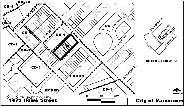
Site, Surrounding Zoning and Development: This 3 247.8 m² (34,960 sq. ft.) site is comprised of nine parcels on the west side of Howe Street Pacific Street. The site has a frontage of 86.8 m (284.6 ft.) and a depth of 36.6 m (120 ft.). The site length along the north south lane is 90.8 (297.8 ft.).
The properties to the east, across Howe Street, contain industrial uses backing onto the Howe Street access ramp to the Granville Bridge. These properties, as well as May and Lorne Brown Park to the south across the east-west lane, are also zoned FCCDD. The property to the west, across the north-south lane, is zoned CD-1 and was developed for residential use under the FCCDD (townhouses along the street, tower above). The sites to the north, across Pacific Street, are zoned Downtown District (Hornby Slopes in Downtown South) and are developed with a range of residential, commercial and hotel uses.
Proposed Development: Neighbourhood Concept: The False Creek Comprehensive Development District (FCCDD), the Granville Slopes Policies and the Granville Slopes Neighbourhood Concept Plan (GSNCP, refer to plan in Appendix F) clearly describes the urban design and planning intentions for this site. In summary, these include the following:
· Density: a maximum density of 4.5 FSR;
· Tower Height: a maximum tower height of 64 m (210 ft., approximately 21 storeys) with relaxations up to 68.6 m (225 ft.) for sculpting of interesting roof forms;
· Floor Plate Size: the recommended floor plate size for the area is 604 m² (6,500 sq. ft.) which is typically found in the neighbourhood;
· Built Form: one tower with low-rise development facing Pacific Street, Howe Street and May and Lorne Brown Park; and
· View Cone: one Council-approved view cone (Granville Bridge to Crown/Grouse view corridor) goes over the south-westerly corner of the site (the proposal complies with this view cone).
Applicants Proposal: The applicant's proposal differs from the applicable policies in several ways:
· Density: FSR of 4.95 ( 0.45 over policy with the additional 10% purchased fromthe heritage density bank): 47 951 m² (157,320 sq. ft.) + 4795.1 m² (15,732 sq. ft.) heritage = total of 52 746.3 m² (173,052 sq. ft.);
· Tower Height: 30-storey residential tower at 91.4 m (300 ft.), approximately 9 storeys and 27.4 m (90 ft.) above policy; staff note that six of these nine storeys are attributable to slimming the tower and three storeys are attributable to adding the 10% heritage density;
� Floor Plate Size: floor plates of 520 m² (5,600 sq. ft.) rather than 604 m² (6,500 sq. ft.) typically recommended, resulting in the slimmer tower form; and
· Built Form: the tower is located approximately 9 m (30 ft.) further south than illustrated in the GSNCP (refer to Appendix E).