|
CITY OF VANCOUVER POLICY REPORT
|

Date: |
January 27, 2004 | |
Author: |
F. Ducote | |
Phone No.: |
7795 | |
RTS No.: |
03879 | |
CC File No.: |
8205 | |
Meeting Date: |
February 24, 2004 |
TO: |
Vancouver City Council |
FROM: |
Director of Current Planning and the Director of Real Estate Services, in consultation with the General Manager of Engineering Services |
SUBJECT: |
A Neighbourhood Commercial Centre on City Lands between Pacific Street and Beach Avenue, and between Howe and Seymour Streets, under the Granville Bridge |
RECOMMENDATION
THAT Council endorse in principle the creation of a small local-serving neighbourhood commercial centre under the north end of the Granville Bridge, subject to a report back on the results of a study on the uses, form, and amenities for the subject area.
CITY MANAGER'S COMMENTS
The City Manager RECOMMENDS approval of the foregoing.
COUNCIL POLICY
Relevant Council policies affecting the study area include:
1984 Southeast Granville Slopes;
1989 Granville Slopes Neighbourhood Concept Plan;
1990 False Creek North Official Development Plan;
1997 Bridgehead Design Guidelines - sets limits on heights and setbacks;
2002 Downtown Transportation Plan - recommends reconfiguring the Granville Bridge loops to create a conventional street pattern to improve sense of entry into Downtown Vancouver and reclaim buildable land;
2002 Pacific Boulevard Redesign - recommends changing the street from Burrard Bridge to Nelson Street into a "great street".
PURPOSE AND SUMMARY
Staff have identified the opportunity to establish a small but unique neighbourhood commercial centre in the area beneath the north end of the Granville Bridge, south of Pacific Street. The centre would serve the needs of adjoining developing high density residential neighbourhoods of the westerly False Creek North neighbourhood, Downtown South and Granville Slopes, as well as provide for local employment opportunities. Existing zoning precludes such uses. The development of the centre would also seek to improve pedestrian and bicycle links between the downtown plateau and False Creek. Consultant services for urban design and retail potential are anticipated as technical bases for possible zoning changes.
DISCUSSION
Residents of the emerging neighbourhoods of the westerly False Creek North development area, Downtown South and Granville Slopes do not have convenient access to daily shopping needs, particularly groceries and related goods and services. If local goods and services were to be made available within a convenient 5 to 10 minute walk of all residents in this area, it would eliminate the need for people to either climb the steep slope to Drake or easterly to Yaletown, a distance of more than 600m to the nearest full service grocery store.
The intended relocation of the impound lot from the subject area provides an opportunity to revisit the disposition and use of these lands. As the largest property owner, the City can also take the lead to see that positive change is realized in a timely and coordinated fashion. Since engineering arrangements for the bridge require long-term City ownership, the proposed direction would continue to respect City requirements through continued ownership while creating a business opportunity for the City that provides for residents' needs and improves access to False Creek. Continuing City ownership of parcels under bridge structures may also provide an opportunity for City involvement in development of the lands (Figure 1).
Figure 1. The Study Area

The Granville Loops area, North of Pacific Street
A staff team comprised of the Planning, Engineering and Real Estate Services Departments and the Housing Centre are currently engaged in scoping a review of the lands in and adjacent to the Granville Bridge loops and ramps north of Pacific Street between Howe and Seymour Streets. The Downtown Transportation Plan recommended reconfiguring the freeway-style loops with a street grid configuration. Upon implementation, this significant change will permit the City to redevelop its adjacent lands to create a fitting gateway to downtown, to provide spacious pedestrian linkages from Granville Street down to the waterfront elevation of False Creek North, and to integrate Downtown South neighbourhoods with the North False Creek community. A separate report to Council outlining the scope of this initiative is forthcoming.
Lands South of Pacific Street
The study area is located south of Pacific Street, with the focus being the Granville frontage north of Beach Avenue. As previously noted, the City owns most of the parcels, which vary in size from single lots to entire blockfaces. Existing uses include the City's impound lot, auto repair facilities and vacant lots. Small buildings of heritage interest are in the area, along with some privately owned lots. A social housing site west of the extension of Seymour Street is included in the study area for adjacency purposes but is not part of the study itself, nor are the properties fronting Howe Street.
Study Objectives
The main objective of the study is to clarify land use and urban design policy about development of the subject lands as a mixed use "neighbourhood centre" to serve the residents of the adjoining neighbourhoods and complement waterfront commercial and marina uses. The centre is also to provide convenient weather-protected pedestrian and bicycle routes in the north-south direction, including linking to a possible future vertical pedestrian/bicycle connection to/from the Granville Bridge. Activity and built form will also contribute to Pacific Boulevard as a "great street".
Desired Land Uses
In general, the proposed centre should accommodate retail sales and services found in Vancouver's neighbourhood centres - greengrocers, fish and butcher shops, a pharmacy, landscape shop, cafes and coffee shops, book stores, dry cleaners, hardware stores, hairdressers and the like. Service-related and professional offices may also be considered as supportive uses, along with other compatible uses that generate local jobs. A separate retail study will provide advice on the preferred sizes and mix of uses, given anticipated demand and available space.
This could also be an excellent place for relocation of retail and service uses that will likely be displaced from the 1400 block of Hornby Street as further buildout of residential development occurs there. Appropriate community uses could also benefit nearby residents. Service stations, mini-storage facilities, warehouses, surface parking lots, drive-in establishments and other pedestrian-unfriendly uses are not anticipated to be accommodated in the future.
Character
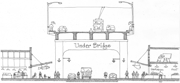
The situation under the bridge has the potential for creating a very special character area of modest scale with full year-round weather protection and wide sidewalks for outdoor retailing, that could lend form to an amorphous area and support existing restaurants and marinas along False Creek. The location of bridge and ramp supports and the Engineering Department's requirement for a 3m setback from the bridge and ramp decks present a serious challenge to physical and economic development. However, if addressed in a creative way these challenges may provide an opportunity to create a unique place. Figure 2 suggests how a "high street" beneath the bridge could look and feel.
Figure 2. The High Street under the Granville Bridge
Deliverables
The planning and urban design consultant will work with staff to identify physical opportunities and constraints, urban design and land use principles, and preferred built form directions for the neighbourhood centre. Illustrative plans, sketches and a design rationale will document this body of work. A separate retail consultant study will provide information about demand and space requirements for specific uses that could locate in the area. Staff will base recommendations for rezoning and parcelization to Council on these studies.
The study is timely as there are potential tenants interested in the area and they need guidance soon so they can make business decisions about location of their premises.
FINANCIAL IMPLICATIONS
The project will be co-managed by the Planning and Real Estate Services Departments, with the participation of Engineering Department staff, and within existing resources. The cost of the urban design consultancy will be $10,000, and $2,500 for the retail report. The source of funding will be the Property Endowment Fund as it owns all the City land involved and will benefit from any new development.
CONCLUSION
Given all the changes in the area, this is a timely opportunity to bring forward for Council's consideration an exciting urban design vision and proposed zoning for a neighbourhood centre on the City-owned property at the north Granville Bridgehead.
* * * * *