 CITY OF VANCOUVER
ADMINISTRATIVE REPORT
Date: |
June 24, 2003 | |
Author: |
Michael Naylor | |
Phone No.: |
604-873-7237 | |
RTS No.: |
03167 | |
CC File No.: |
8023 | |
Meeting Date: |
July 10, 2003 |
TO: |
Standing Committee on Planning and Environment |
FROM: |
The Director of Current Planning in consultation with the Director of City Plans, the General Manager of Parks and Recreation, the Director of the Housing Centre, the Director of Cultural Affairs, the Director of Social Planning and the General Manager of Engineering Services |
SUBJECT: |
East Fraserlands Planning Program - Progress Report |
RECOMMENDATION
THAT Council receive for information this progress report on the East Fraserlands Planning Program and authorize staff to proceed to the next phase of public consultation.
GENERAL MANAGER'S COMMENTS
The General Manager of Community Services RECOMMENDS approval of the foregoing.
COUNCIL POLICY
· Fraser Lands: Land Use Report, approved November 1987
· Industrial Lands Policies: Fraserview, approved March 1995
· CityPlan, approved May 1995
· Waterfront Pedestrian / Bicycle Pathway Widths Policy, 1997
· City-wide CAC and DCL Policy, 2000
· Regional Context Statement ODP, 2000
· Victoria Fraserview-Killarney Community Vision, approved January 2002
· East Fraserlands Planning Program, approved May 28, 2002
· Cost Recovery Policy
· City Non-Market Housing Policy
· Financing Growth
PURPOSE AND SUMMARY
This report informs Council of the current status of the planning work for East Fraserlands which began in July 2002. It also seeks Council's endorsement to proceed to the second round of public consultation.
After a long, iterative process working with the proponents since July 2002, a concept plan has been drafted for the East Fraserlands which is ready for public review. While the plan goes a long way to balancing the many competing economic and policy objectives surrounding this site, there are a number of outstanding concerns outlined in this report to do with residential density, building heights, commercial land use, public amenities and development phasing. Rather than seek Council's direction on those issues at this time, staff propose to seek the public's input and then return in the fall with a draft Policy Statement and specific recommendations. To that end, this report is for Council's information.
BACKGROUND
This report is a follow-up to an information report dated September 19, 2002 which reported on the status of the East Fraserlands. A number of areas of concern were identified in that report and further work has occurred involving staff and the proponent team. The proponents consist of the two major owners of property in the study area. Weyerhaeuser owns 69.9 acres south of Kent Avenue and the City of Vancouver (represented by Real Estate Services) owns the majority of the land north of Kent (36.5 acres). About nine acres of land included in the planning area belong to other owners who are not participating as proponents in the process. Both Weyerhaeuser and the City intend to sell their properties to others who will redevelop. Two interested developers, ParkLane Homes and WesGroup Income Properties, have been working with Weyerhaeuser as part of the proponent team since November 2002.
The goal of the current planning program is to have an adopted Policy Statement for the site along with an "Illustrative Plan." The Policy Statement will inform the next phase of planning work which will either be rezoning or an Official Development Plan. The proponents have requested that an Illustrative Plan be part of the current program so that plan-related elements, such as required land dedications, density distribution, building heights and land-use allocation can be determined with greater certainty than is typically done in a policy statement. The proponents have also requested that the City determine the level of the public amenities that will be required for the project. While the plan elements and amenity requirements are usually addressed at a later stage in the planning, these items have great importance to the proponents in their business decisions about the site, so they have requested that they be considered now. The City has engaged the services of Coriolis Consulting to provide the economic analysis.
Currently proposed for the site is a predominately residential community of about 9,000 people in a variety of housing types. The plan includes a substantial commercial component proposed in the form of a high street that also serves as the core of a neighbourhood centre. The new community is to include parks, a riverfront walk, a school, childcare facilities and other public amenities. It would be built out over a period of about 20 years.
Many areas of agreement have been reached between the proponents and city staff on an initial concept. There are also some issues which are still outstanding, such as the scale and nature of the commercial component, overall residential floor area and building heights.
Public consultation last occurred on this project in July 2002. It will be beneficial to the process to undertake more consultation as a next step prior to drafting the Policy Statement and final plans for the site. It is proposed that this consultation begin right away this July. A draft policy statement and final plan will be drafted later in the summer and presented again to the public for final comment, before seeking Council's approval in the fall.
Figure 1 - East Fraserlands Planning Area

DISCUSSION
Industrial Use
The September report discussed the prospect of the site remaining in industrial use. The site is not considered strategic to the Industrial Lands Policies which are neutral on whether it should be retained for industrial use or let go. Due to its proximity to existing residential areas, it is less suitable for heavy industry than other sites along the Fraser River which are more clearly protected by policy. Light industry remains a land-use option that is supported by policy should proposals to develop it as such come forward.
But, since industrial use is not mandated and there has not been market demand to redevelop under the industrial zoning, the focus of the current planning effort has been to examine other uses. Still, in examining the economic viability of those other uses, the industrial land values are used as the base against which the value of the other uses is compared. Should the site be unable to economically support residential use at this time, including an adequate level of amenities, then industrial use remains as a viable option.
Soils Constraints
New information has arisen since September as a result of ongoing soils and geo-technical investigations. Soil contamination will not be a major constraint to redevelopment on the site except for an area on the riverfront in the centre of Weyerhaeuser's land, which has deep creosote contamination. This area will be subject to remediation measures over a long period of time resulting in severe constraints on redevelopment. Weyerhaeuser has commenced the remediation process on their site.
There are also geo-technical constraints on development particularly south of Kent Avenue, in the middle and eastern portions of the site. The presence of soft soils challenges tower construction in these areas. A stabilization dike will have to be constructed along the river's edge to stabilize soils prone to liquefaction.
The Draft Concept
A concept for the site has been drafted which works with the site's constraints and opportunities, while seeking to balance the objectives of existing City policies with the business needs of the landowners and prospective developers. (See Figure 2.)
The proposed plan overlays the site with a grid pattern of new streets forming about two dozen blocks to receive the new development. Three dedicated crossings of the rail would be opened in addition to the existing ones across Kerr and Boundary. The open space system features three neighbourhood-size parks evenly distributed near the water across the site, linked by a continuous "riverwalk" along the waterfront.
In the middle of the site, a north-south "high street" extends from Marine Way to the river which is to be the focus of a new "neighbourhood centre" containing retail services and community amenities such as a school, childcare facilities and indoor recreation space. The riverfront, at the end of the high street, is to be a vibrant and active public place with restaurants and maritime-related activities.
The remaining blocks, on either side of the neighbourhood centre, will be all residential featuring a range of housing types with an emphasis on ground-oriented housing. Various aspects of the plan are explained in further details in the following sections.
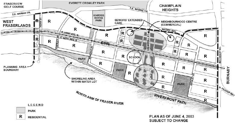
Figure 2 - East Fraserlands Draft Concept Plan
Residential Use: Residential use on this site is supported by a number of Council policies. Consistent with the Liveable Region Plan, it is a substantial infill site close to the metropolitan core that can accommodate new growth without infringing on limited agricultural lands and forests. On a local scale, the community vision for the Victoria-Fraserview/Killarney (VFK) area supports housing on this site, at a higher density than single-family.
The current plan proposes a range of housing types and densities from townhouses to apartment towers. An important objective for this site is to provide a large proportion of the housing in the form of ground-oriented housing which is suitable for families and a range of other household types. Small-lot freehold rowhousing is proposed as part of the ground-oriented housing which would meet a recognized demand in Vancouver for freehold tenure.
While residential use on this site is well supported by policy, two concerns were raised by the public in July 2002: 1) The proposed overall density for housing in East Fraserlands is higher than the surrounding areas to the west and north. There is concern that this will result in a population that is too high, creating transportation impacts, particularly because the area is at present poorly served by transit. 2) In order to meet the objectives for ground-oriented housing as well as achieving the landowners' density objectives, tower development is necessary. Towers are being suggested by the proponents as high as 28 storeys. Existing development in West Fraserlands has a maximum height of 14 storeys and some residents expressed difficulty envisioning this area as suitable for taller towers.
The residential densities contemplated for this site will result in a population increase of 8,000 to 10,000 people depending on the final density and area devoted to housing. The advantage of such a population is that it creates a critical mass needed to support a neighbourhood centre including retail, transit and community services and amenities. The low population of West Fraserlands (4,000) does not provide the critical mass required for retail and other services. The concern over the lack of transit and fear that the new population will be auto-dependent is understandable, but a critical mass of people is essential to make commuter transit service viable and local services available so that trips by car can be reduced. The site is well suited for future rapid transit access and for expanded bus access.
The concern over tower height is also understandable for this area of the city which, apart from the West Fraserlands towers, is predominately low-rise. The towers in West Fraserlands have a golf course upland of them, so that view impacts were less of an issue. East Fraserlands has views from Champlain Heights and from Everett Crowley Park which may be impacted by towers. The proponents have been asked to illustrate what the towers would look like and where they would be located for the upcoming round of public consultation. This is important as the information provided on building heights at the July 2002 open houses was very preliminary and conceptual. The public requested more information on the location and design of the towers.
In the upcoming round of public consultation, staff will seek reaction to the proposed population, the mix of housing types, the building heights and the character of the neighbourhood, before drafting relevant policies for the residential component.
Commercial Use: The proponents' initial proposal included a 250,000-square-foot destination shopping centre on 20 acres of land at the far eastern end of the site, adjacent to Boundary Road and Burnaby's industrial park. This proposal was not consistent with the Community Vision policy for Victoria-Fraserview/Killarney which indicated commercial use at Kerr Street. That policy also limits commercial activity in a redeveloped East Fraserlands to the level required to serve the whole Fraserlands area, but not the broader community. Nor was it consistent with CityPlan policies concerning "neighbourhood centres." CityPlan policies call for the creation of neighbourhood centres to provide a "heart" for a community by clustering the commercial activities with community facilities in a location that is walkable from surrounding residential areas. Public reaction from last July supported existing policy. Concern was expressed about traffic impacts of retail that draws from a wide area. Big-box stores were not supported, but typical neighbourhood-serving stores providing for food and basic household needs were. Restaurants and unique businesses along the riverfront were also supported.
In the current plan, the proposed commercial has been moved to a more central location in East Fraserlands where it can better function as a walkable destination from the planned community and from part of the existing West Fraserlands area. Its form has evolved into a "high street" on an extension of Cromwell Street from Marine Way to the riverfront. The proposed school, community space, and a riverfront park are located nearby. The total proposed floor area has been reduced to 200,000 square feet with 140,000 square feet north of Kent Avenue and 60,000 square feet to the south. The current proposal anticipates that the portion to the north of Kent would include a major food anchor (about 40,000 square feet) plus another 40,000 square feet of anchor space (such as a drugstore or hardware store) either as a single store or divided between several smaller stores. The remaining 60,000 square feet would consist of a number of smaller shops, services, and a gas station. Large-format (big-box) stores, of the type permitted in the Highway-Oriented Retail Areas further west on Marine Drive, are not proposed. The proponents would like the commercial floor space north of Kent to be built in the first years of the 20-year project.
The concept for the commercial portion stretching south of Kent to the river is to add a south anchor to make the whole high street viable with the north portion related to a Marine Way exposure and the south to a maritime village entertainment focus. This area would likely include a mix of local-serving retail and service uses together with restaurants, cafes, speciality shops, and possibly some commercial activities similar to those occurring on Granville Island or in Steveston. The proponents are proposing that this commercial space be developed in later phases of the project, when demand warrants its construction.
The location of the proposed commercial is generally supported because it would be central and within easy walking distance for the anticipated 8,000 to 10,000 residents of the new community. It would also be reasonably close to people living in West Fraserlands. Additional work is needed in the next planning phase relating to the impacts, form, and scale of the commercial development.
Coriolis Consulting, the City's economic consultant for the project, was asked to comment on the amount of commercial space which might be supported by the community's population at build out. At the abstract level they were reviewing, and based on gross assumptions, they advised that in the order of 100,000 square feet of floor space could be supported by the residents of the new community and the existing Fraserlands development. This is only half the commercial floor space proposed by the proponents. Consistent with the wishes of the proponents, Coriolis also advised that early development of commercial uses would improve the economic return generated by the site.
After further review with Coriolis and the proponents, there is a rationale for allowing some commercial floor space beyond the amount that would be local serving in order to help create a vibrant commercial core for the community. Developing the first phase of the commercial space in the short-term is also economically desirable and supportable. This conclusion is based on several factors:
· the belief that the lack of local-serving retail for the existing residents of West Fraserlands should be addressed in the short term;
· feedback from the July open houses that indicated that a food store was considered to be desirable by many West Fraserlands residents;
· a recognition that a food store is an important component of most successful neighbourhood centres and that few food retailers would be willing to operate the smaller (20,000-square-foot) store that the projected population alone could support;
· an acceptance of the argument that some additional commercial floor space would serve existing commuters using Marine Way rather than attracting new traffic;
· concern that development of large-format stores on Marine Way in Burnaby could pre-empt desirable commercial uses in East Fraserlands unless retail development was permitted in the short term.
Clustering all the commercial space in one location, rather than scattering it in a few smaller nodes, is also supported because a single location is more likely to create a vital neighbourhood centre.
However, support for more commercial floor space than would be required by the projected population, and for completing most of that floor space in advance of residential development, is contingent on:
· a configuration of the anchor stores in the first phase of development which strongly supports pedestrian use of the north-south high street;
· a study to establish the size of a food store (with a maximum size of 40,000 square feet) that would not damage food retailing in existing centres (especially Champlain Mall, Collingwood, and Victoria Drive);
· a study to establish type and size of the other anchors (with a total of no more than 40,000 square feet) that would not damage anchors in existing centres;
· the development of an acceptable mechanism to ensure that the size and function of the first-phase retail (north of Kent) does not pre-empt development of the high street south of Kent to the Fraser River as residential development unfolds;
· parking which does not exceed ratios in the City's Parking By-law and which is configured in a manner which is consistent with the development of a neighbourhood centre;
· the look and feel of all commercial development being consistent with the concept of a neighbourhood centre which acts as the "main street" heart of the emerging community.
Finally, while a case can be made for an amount of retail floor space that is beyond the local-serving amount called for in the Community Visions policy, the range for consideration would be from 140,000 square feet (for a mostly neighbourhood-serving commercial area supported by a mid-size food anchor) to the 200,000 square feet in the draft plan (with its wider array destination commercial space).
In the next round of public consultation, the City will seek public reaction to the high street concept and the scale of proposed commercial, before drafting relevant policies for the site.
Urban Structure: In the September report, the size of the blocks and number of streets was raised as an issue. Proposed was a small number of streets that resulted in large blocks, similar in scale to the surrounding areas of West Fraserlands and Champlain Heights. In these areas the street rights-of-way occupy about 20% of the gross land area, whereas in a typical Vancouver block pattern about 30% of the land area is devoted to streets. Fewer streets have to carry more traffic. Large blocks result in the use of private roads to access buildings. There is often poor pedestrian access as there are fewer ways to pass through an area and diminished space overall for the public realm.
Noticing that economic viability is sensitive to the amount of land that has to be dedicated,
a balance is sought in a street network which attempts to meet the needs of circulation and the public realm while minimizing the dedication requirement. While the design of the street network is still under discussion, the current plan has a system that more or less achieves a good balance. That system would see about 25% of the land area devoted to streets, although it depends where dedicated lanes may be needed and whether some public access ways can be achieved through statutory rights-of-way instead of dedication. The objective for street character will be for narrow, calmed, tree-lined streets that are an attractive focus for community life and friendly to pedestrian and bicycle traffic.
Public Amenities
The City seeks to secure within new communities a level of services and amenities for new residents and employees. When planning large new communities, an amenity package is negotiated based on a series of factors including projected community needs, public input, neighbourhood context, past practice, City standards for services, and an economic analysis of the proposed development that takes into consideration the change in land value resulting from a change in zoning. In each case, staff recommend Council approve a negotiated package of public amenities and facilities to be provided by the developer.
Most major downtown projects (Coal Harbour, Bayshore, and False Creek North) provided a very high level of amenity because land value increases were dramatic between moribund industrial/rail use and high-density residential use. The non-downtown projects (Arbutus Neighbourhood, Collingwood) provided a more modest package of amenities which corresponded to the more modest increase in land value. In some instances, to ensure an adequate level of service and amenities for a new community, Council has also approved supplemental measures such as Capital Plan allocations. Or, more recently, City-wide DCLs collected from a particular development area have been applied to DCL-eligible amenities which have been provided within the development boundaries as part of a negotiated amenity package. While the level of amenity provided in these instances is different than in downtown major projects, the resulting neighbourhoods have proven to be successful in terms of neighbourhood and market acceptance.
In accordance with the Community Amenity Contribution Policy, East Fraserlands, as a "non-standard rezoning," will require a negotiation to determine the appropriate amenity package. To determine the financial ability of the project to provide the desired public amenities, the City has engaged Coriolis Consulting to undertake a pro-forma analysis. The pro-forma measures the economic potential available under the existing zoning against a proposed new use and density. Since residential units achieve a lesser price in these outlying areas than in the downtown, the expected increase in land value going from industrial to residential use will not be large enough to achieve a standard of public amenity comparable to the major downtown projects.
Coriolis undertook an initial analysis in December based on some preliminary assumptions about land uses and floor space and not on a specific plan. It showed that the project was close to being viable after delivering an amenity package outlined in the following sections. This initial pro-forma analysis indicates that with a specifically tailored package of public amenities, the transformation of the area from industrial to residential appears economically viable. In response to the results of the analysis, staff came up with some further changes to the plan to realize this economic viability: 1) that the amount of dedicated road area be reduced by about three acres; 2) that undeveloped, City-owned parcels on the west side of Kerr Street be considered for residential redevelopment; 3) that up to five acres of land could be considered for seniors' extended care use instead of residential and commercial; and 4) that the school site to the west be foregone (and made available for residential development) in preference to an amalgamated larger site near the neighbourhood centre in East Fraserlands.
The economic analysis is still preliminary and must be revised after public feedback has been received and analyzed, and the development options are further refined.
Parks and the Riverfront Walk: Comments received at last year's public events showed that parks are very important to the local community. The vast majority of respondents expressed a desire to achieve the full park standard in the East Fraserlands. Of primary importance to most was the continuation of the public waterfront with a naturalised foreshore and with bicycle and pedestrian paths. Many people also mentioned the re-creation of natural watercourses as an important interest.
Compared to the rest of the city, Killarney is rich in parks, with 7.0 acres of neighbourhood park per 1,000 residents. Everett Crowley Park alone is 94 acres, plus there is an array of smaller parks and greenways. Because Killarney's parkland more than meets existing park standards, staff felt that the amount of park achieved in East Fraserlands was of less of a priority than other park planning objectives such as location, good distribution, variety, functionality, waterfront potential for public access and use, linkages and environmental performance.
The proposed park and open space system features three parks, each of 3 to 6 acres in size, on the riverfront connected by a continuous waterfront pathway. Part of the park land is proposed as a green corridor that would connect the river to Kinross Ravine. The corridor would provide the opportunity for a watercourse. The ravine has a stormwater culvert which might eventually be opened to the watercourse depending on flow, water quality and environmental regulatory approvals. The corridor would also provide a green link to Everett Crowley Park.
The combined total land area of parks and path is proposed at 15 to 17 acres, depending on the population. This would give a park ratio of about 1.7 acres per 1,000 residents for the new development itself, while the neighbourhood park ratio for all of Killarney would become 5.6 acres per 1,000 residents. The proposed park and open space system generally meets the park planning priorities identified for this site, so staff support this approach. In the next phase of planning work, the City will seek public reaction to the amount, configuration and design of the parks, before drafting relevant policies for the open space system.
School and Community Facilities: A 1.5-acre school site is proposed in the current plan which would accommodate a grades K-to-12 school. This school would be in lieu of an elementary annex proposed for a site west of Kerr Street. The West Fraserlands school site was obtained by the City through the development process, however the Vancouver School Board has not yet built the facility.
With 8,000 to 10,000 people proposed and a high concentration of family housing, staff are looking at one school large enough to accommodate students from the East and West Fraserlands developments and to include both elementary and secondary students. Requiring a secondary school is somewhat unusual but given the capacity enrolment at the closest high schools, there is a concern that the area's projected 600 high-school students may need to bus or drive an unacceptable distance to school.
The K-to-12 school is suggested for the centre of the East Fraserlands site, near the high street and in the neighbourhood centre. In order to make the most efficient use of land and to foster community interaction, it is proposed that the school play fields be located within the park areas, and that approximately 10,000 square feet of indoor recreation space, a 69-space childcare and 45-space out-of-school care facility be co-located with the school in a community "hub."
Of concern for the public will be the timing of the community hub. While the site will be secured as a condition of development, the construction funding for the school is dependent on provincial funding programs. Careful planning for the phasing and delivery of the community hub amenities will be required as has been done in other major projects to ensure that they can be delivered in a timely manner independent of provincial funding programs.
In addition to the community hub, childcare facilities are proposed throughout the site in a variety of types of facilities which would include another 69-space daycare centre and 10 small "family" daycares which will likely be designed into non-market family housing projects. The childcare proposed will secure an initial program at the outset of the development. Given the focus on family housing and an expected high concentration of young families, future demand may surpass this program and ways of augmenting the childcare provision will have to be sought.
A public art budget is proposed that will enable a meaningful contribution to the three park areas as well as to the waterfront walkway. By focussing the art budget in the public open space, staff believe that an acceptable level of amenity can be achieved within the economic resources available on this site. A library contribution is not being sought as the Champlain Library was recently expanded.
Given limited value increases projected from an industrial-to-residential rezoning, new neighbourhood-scale developments outside the inner-city (Collingwood and Arbutus Lands, for example) have not been able to derive solely from project economics all public facilities and amenities at theoretically full standards. Instead, a strategic approach must be adopted whereby:
· a tailored amenity package meeting essential needs is achieved through the project economics;
· amenities are secured that otherwise cannot be technically or easily secured through other means (such as open space);
· it is practical to augment initial amenities as need be over the years, based upon expressed rather than theoretical demand; and
· it will be reasonably within the economic means of the City to round out the amenity provisions in the future.
As such, it is likely that some further amenities will be garnered for the new community in the future in the normal competition with other neighbourhoods for civic resources, such as from City capital plans.
In the next phase of planning work, public response to the proposed public amenities package will be obtained.
Affordable Housing
The City's policy is to require that 20% of the units in new neighbourhoods be set aside for affordable housing (i.e. non-profit co-operative and rental housing - previously called "non-market" housing) with a priority on core-need households. The purpose of this policy is to ensure that there is an income mix in new neighbourhoods and that low and modest income households have an opportunity to live in them.
The policy assumes that senior government funding for affordable housing is available. The requirement imposed on the developer of a new neighbourhood is to make the affordable housing sites available at a price that works within the maximum budgets established by the senior government programs. These budgets are based on average multi-family land costs in the region.
In high-value locations, such as Coal Harbour and False Creek, this requires that the developer provide the sites at less than market value, an implied subsidy from the developer. In lower value locations, the affordable housing land value is typically equal to the market value and no subsidy is required from the developer. This is the case with East Fraserlands now as it was when the West Fraserlands was developed a decade ago. Consequently, the developer of East Fraserlands should not need to provide a subsidy for the affordable housing component, and requiring that 20% of the units be set aside for affordable housing will not compromise the economic viability of the project as the developer will receive market value for the affordable housing sites. However, the developer does make the sites available to the City.
It is proposed that the developer(s) of East Fraserlands be required to set aside 20% of the units for affordable housing. The challenge for the City will be the possible lack of senior government funding for affordable housing. Currently there is little Federal or Provincial funding for affordable housing, and what funding that exists is limited and requires contributions from other partners. If the East Fraserlands sites were ready to be developed now, the City would have to consider options of how to develop the sites outside of senior government programs or possibly to forego the opportunity all together. The funding context may change before affordable housing sites in East Fraserlands become available, or over the course of the development, so it is prudent to set aside the necessary sites for the amount of such housing preferred. However, it needs to be noted that realizing the City's mixed income objectives for East Fraserlands will be difficult in the absence of senior government funding programs.
Relationship to City-wide DCLs
Assessments pursuant to the City-wide DCL By-law will be paid to the City as development proceeds in the East Fraserlands. These funds may be expended on eligible capital projects such as: constructing drainage and transportation works; providing and improving park land; establishing daycare facilities; and providing replacement housing. Staff will be recommending in a subsequent report to Council that DCL funds collected from development in East Fraserlands pursuant to the City-wide DCL By-law be spent on specific eligible capital projects within East Fraserlands that are identified in that report.
Phasing of Development and Delivery of Amenities
Critical to this project's success, both in terms of meeting policy objectives and in terms of being financially viable, is the timing at which it proceeds. Amenities and commercial services should become available as the population grows. The early development of commercial uses north of Kent Avenue should not jeopardize the development of the high street south of Kent. To meet these goals, a sound phasing strategy should be devised in the Policy Statement and adopted as part of the development requirements.
Sustainability
The proposed plan addresses sustainability through the reuse of an old industrial site, remediation of degraded soils and foreshore conditions, preservation of a waterfront and open space system for public use, and provision of mixed uses within a highly liveable and walkable community. Relocation of the retail component to the middle of the site increases opportunities for pedestrian access and the creation of a community heart. The current plan also addresses social sustainability by ensuring that a variety of housing types, both market and non-market be developed to meet the needs of families, singles, elderly, children and persons with special needs.
Early in the process the proponents commissioned Holland Barrs Consulting to identify sustainability opportunities and constraints for the site. Development of those sustainability options is anticipated as the project develops and they will be fleshed out in the Policy Statement and as part of the package of public requirements that will apply to the development. Specific areas for consideration include built-form initiatives (passive solar heating, green buildings, etc), rainwater management, and alternative energy management systems. Staff are pleased that the proponents have agreed to examine what they can offer regarding sustainability, and look forward to that contribution and the public's reaction to it.
Public Consultation and Assessment
The major public consultation on this project was in a series of open houses in the Fraserlands and Champlain Heights communities in July 2002. At that time there was only preliminary information to show the public, but the events were well attended and many comments were received. The second round of public process has been delayed for a number of months while the proponents regrouped to include the prospective developers. Some members of the public have expressed concern over the lack of consultation, including the Victoria-Fraserview/Killarney Vision Implementation Committee after a brief presentation on the status of the project at their annual general meeting.
It is proposed to get out to the public as soon as possible to show them the plan and receive feedback on the issues outlined in this report. The proponents have been requested to prepare a package of drawings that illustrates the full range of proposed building types (including proposed towers), the neighbourhood centre, the open space system, the public realm and sustainability potentials.
The format for this second round will include public open houses and community meetings/workshops that enable group discussion and review of proposals. Topics of high interest, such as parks, will have separate meetings if necessary. It is proposed that the open houses will be held in late July with follow-up meetings held in August and extending into early September. Staff will be sensitive to the fact that people may be away during the summer and schedule events accordingly.
After receiving and assessing public feedback, a policy statement and final plan will be drafted and taken back to the community in the fall, prior to being presented to Council for consideration.
FINANCIAL IMPLICATIONS
There are no financial implications related to completing the planning program. A budget for the planning work, together with a work program, was approved by Council on May 28, 2002.
PROPONENTS' COMMENTS
Context: Planning in the south-east sector of Vancouver has evolved over the past 40 years. Following the closure of the Kerr Road dumpsite in the mid-1960s, the City initiated a planning process for the Champlain Heights area which led to the redevelopment of ±150 acres of City-owned land during the 1970s and 1980s. The City-initiated planning and development of the Riverside and Fraserlands neighbourhoods came next - in the late 1980s and early 1990s.
The `missing piece' has been Weyerhaeuser's Canadian White Pine and K3 operations at Marine Drive and Boundary Road. While the previous planning activities respected Weyerhaeuser's ongoing operations at this location (and the City decided not to pursue development of their lands to the north), there was a general acknowledgement that this site would one day make the transition to some type of residential use.
For the past fifteen months, the proponent team of Weyerhaeuser / ParkLane / WesGroup and the City's Real Estate Services have been working with City staff to create a mutually supportable Policy Plan that will permit these lands to become an exciting new addition to the existing residential communities in south-east Vancouver.
The Importance of Balance: A cornerstone principle of the East Fraserlands project is to achieve a `balance' - a balance of commercial, residential, and amenity uses that create a vibrant, liveable new neighbourhood with a unique character that is at the same time financially attractive to a developer to pursue the transition from industrial to residential use. To date, we have not quite achieved consensus on the entire basket of components that need to come together to create this `balance' - but a number of challenging and difficult issues have been resolved and there is a solid understanding of the various components.
Residential Uses: Redevelopment of these lands provides Vancouver with an opportunity to create a new residential community. The plan could accommodate up to 9,500 people in approximately 5,000 residential units. This residential community would be situated next to approximately 15 acres of waterfront walkways and public open space. This new community will provide a broad range of housing types from fee-simple row houses to high-rise apartment units.
In terms of the residential density and, by extension, building height, it is noted that the East Fraserlands community will be more `urban' than its surrounding counterparts. The City and proponent team have worked very carefully to develop a strategy that varies building height across the site to minimize the impact of existing views.
Commercial Uses: The commercial uses - particularly on Marine Drive - are the financial engine of the project. The very first iteration of the plan proposed 250,000 square feet of commercial uses on 20 acres on the Boundary Road edge. The intent was to provide upfront revenue to the project pro-forma to help fund amenities and services for the new community.
Through a series of plan revisions, the commercial precinct has migrated to the centre of the site and has also been reduced in overall size. The commercial now forms a `High Street' retail spine that connects the commercial component on Marine Drive with the mixed-use residential uses to the south.
The commercial uses continue to be a fundamental part of the `balance' of the project. It must also be stressed that the Marine Drive component is relatively more important to the overall viability of the project. The current plan - which anticipates 140,000 square feet of commercial uses adjacent to Marine Way - is believed to represent the minimum viable development program. Reducing the floor area further may, we believe, prevent the commercial area from achieving the needed critical mass and jeopardize the project's ability to deliver the package of amenities envisioned for the area.
The High Street commercial uses south of Kent Avenue will only be viable once there is a substantial residential population in the immediate area. We have learned from the West Fraserlands neighbourhood that it is not dense enough to support local-serving commercial uses. To make the High Street work in East Fraserlands, people need to be in place first before shopkeepers will take the risk to open a new store.
Amenities: With respect to amenities, we believe that the plan must also provide a `balance.' The single most important amenity will be the new waterfront walkway that will connect with existing walkways in the West Fraserlands and Burnaby. This was such an important part of the amenity package that it has been on every iteration of the plan.
The parks that are planned have the potential to provide a variety of active and passive uses. If the parks are well-planned, the physical area of the park space becomes a matter of perspective. Again, it is a question of balance - weighing the diverse needs and demands for park space, childcare, and other amenities to achieve a mix that responds to the needs of this new community.
There also needs to be a mechanism to balance the amenity and infrastructure costs across the various property owners (i.e. Weyerhaeuser, City of Vancouver, Spools Lumber and Public Storage). For instance, at present, almost all of the park area is located on the Weyerhaeuser land - there needs to be a funding mechanism to correct this imbalance.
Proponents' Conclusion: While preparation of the Policy Plan has been a lengthy process, we believe that the components of the plan represent a viable balance of amenities and economics that, if ultimately supported by the community and Council, would see this area of the City become a truly vibrant new Vancouver neighbourhood.
CONCLUSION
This report provides information on the progress of the East Fraserlands planning program. With Council concurrence, staff will proceed with the second round of public consultation prior to drafting a Policy Statement for the site.
* * * * *