Appendix B. RAV Proposal - Cambie Corridor Land Use and Compatibility
City of Vancouver
April 4, 2003
I. RAV Proposal: Cambie Corridor
The Cambie corridor has been identified as a preferred alignment for a regional-scale rapid transit service in numerous technical studies and in the Vancouver Transit Strategy. The primary advantages of a Cambie route are the number of regional-scale destinations along it (e.g. hospitals, Langara College, City Hall, Central Broadway business/medical district) and the potential for redevelopment on specific sites along the route. It is also a relatively short and direct route between Richmond and Downtown Vancouver, the region's largest employment centre with 143,000 jobs in 2001, and potentially 175,000 jobs in 2001. These factors contribute to Cambie having a higher potential ridership than other corridors. The public ownership of the right-of-way is an additional advantage.
Characteristic of the Cambie route is that traffic and topographical conditions require the line to be in tunnel at least as far south as King Edward Avenue, and likely beyond to 37th or 49th. As well, the Cambie Heritage Boulevard, from King Edward Avenue to Marine Drive, was designated by Council in 1993 as a heritage landscape.
The base case alignment proposed by the RAV Project for the Cambie Corridor is for the line to start at Waterfront Station (at Cordova Street), run along or under Granville Street, under Davie Street, under False Creek, then down Cambie to the Fraser River and a crossing to Richmond. One alternative would see the line run on Granville but then turn on to Robson, cross False Creek on a new bridge, and rejoin the base case alignment in the vicinity of Cambie and Broadway.
TransLink is currently studying rail transit options for the Northeast Sector of the region. One option under consideration is a diesel light rail service that would run from Coquitlam and Port Coquitlam through south Vancouver, using the Canadian Pacific Railway tracks along the north side of the Fraser River. This service could tie into a Cambie RAV line at Marine Drive.
Ability to Serve Land Use South of False Creek
The Cambie corridor contains several large, regionally-oriented commercial and institutional land uses. The corridor, as defined by a 1,000 metre radius around the five base-case stations, contains 19 million square feet of industrial and commercial space. There are 20,400 jobs located within a seven minute walk (500 m radius) of the base-case stations. If the walking radius is extended to fifteen minutes (1 km radius), an additional 34,000 jobs would be captured. See Table 1 for details.
The bulk of employment which could be served by RAV is in the eastern portion of the Central Broadway medical/civic precinct. There are also significant concentrations in the 41st and 49th Avenue station areas, such as Oakridge Shopping Centre and Langara College. RAV's effectiveness in serving Vancouver General Hospital is reduced by the distance from the Broadway station to the various hospital facilities; this ranges from 500 to 950 metres.
The hospitals on Oak Street (Womens & Childrens, GF Strong) contribute many jobs within a 10 to 15 minute walk of the King Edward station. An additional station at 33rd Avenue would provide more convenient access to these facilities. The Marine Drive station would provide access to jobs in the Marine Drive Industrial Area.
A number of the employment uses in the corridor also generate large numbers of non-work trips. Examples include:
· students travelling to Langara College (7,500 students) and language schools on and near Broadway;
· shoppers patronizing Oakridge Centre (17,500 visitors/day), City Square and Central Broadway retailers;
· people attending medical specialists in the Central Broadway area; and;
· visitors to the City Hall and the hospitals along the corridor (VGH and Women's & Children's each have 7,500 visitors/day).
Housing in the corridor includes a variety of types, ranging from single-family dwellings to apartment towers. Altogether, 14,350 residents live within a seven-minute walk of the proposed stations. If the walking radius is extended to fifteen minutes an additional 36,700 residents would be captured.
Ability to Shape Land Use South of False Creek
There is potential for RAV to foster growth in the employment base in the corridor. Current zoned capacity allows for an additional 13 million square feet of commercial and industrial space, generating over 30,000 new jobs, for a total of 85,000 jobs. Adding stations at 2nd Avenue in Southeast False Creek and at 33rd Avenue would shorten walking times from some employment areas and add another 2,000 jobs to the overall catchment.
Future development could add up to 23,000 more residents to the population served by RAV. Current zoned capacity allows for 5,000 additional residents. Beyond this, additional growth can be achieved though the Oakridge-Langara Area Plan (2,900 more residents), likely redevelopment of institutional properties (1,500 to 1,800 more residents), and the Southeast False Creek sustainable community (12,850 residents). Adding a station in Southeast False Creek would make access to the RAV line convenient for future residents and connect to the Downtown Streetcar for travel to the south shore of False Creek and Granville Island.
Table 1. Population and Employment: Cambie Line outside Downtown | |||||||
Population 2001 |
Commerce & Industry sq ft 2001 |
Jobs
|
Zoned population capacity |
Population capacity (re-zonings) |
Jobs capacity |
Regional Serving sites | |
SE Creek - 500m core |
1,612 |
2,233,604 |
5,410 |
150 |
12,850 |
2,739 |
|
SE Creek - next 500m |
533 |
1,697,792 |
3,691 |
- |
2915 |
||
Broadway - 500m core |
3,785 |
4,205,201 |
11,812 |
701 |
6,038 |
BC Cancer City Hall | |
Broadway - next 500m |
9,924 |
5,711,271 |
15,826 |
1,056 |
4,298 |
VGH | |
King Edward - 500m core |
3,211 |
73,556 |
373 |
534 |
69 |
||
King Edward - next 500m |
8,335 |
577,027 |
2,468 |
1,979 |
840 |
W&C Hospital | |
33rd - 500m core |
960 |
430,655 |
4,331 |
4 |
1,150 |
- |
|
33rd - next 500m |
695 |
60,324 |
175 |
3 |
- |
||
Oakridge - 500m core |
2,239 |
896,671 |
3,385 |
- |
765 |
123 |
Oakridge Mall Centre |
Oakridge - next 500m |
4,030 |
298,241 |
682 |
166 |
935 |
54 |
|
49th Ave - 500m core |
2,169 |
81,033 |
197 |
2 |
110 |
- |
|
49th Ave - next 500m |
4,653 |
169,941 |
1,787 |
64 |
1,600 |
74 |
Langara |
Marine - 500m core |
2,785 |
1,065,343 |
2,472 |
99 |
5,037 |
||
Marine - next 500m |
6,783 |
2,259,859 |
4,317 |
177 |
9,339 |
||
Current 5 stations |
|||||||
500m core |
14,352 |
6,914,241 |
20,386 |
1,336 |
2,515 |
12,769 |
|
next 500m |
36,718 |
12,438,104 |
34,188 |
3,592 |
14,250 |
16,854 |
|
51,070 |
19,352,345 |
54,574 |
4,928 |
16,765 |
29,624 |
||
All 7 stations (adding SE False Creek and 33rd Avenue) | |||||||
500m core |
16,761 |
8,986,063 |
27,980 |
1,490 |
14,875 |
14,152 |
|
next 500m |
34,953 |
10,774,455 |
28,946 |
3,446 |
2,530 |
17,520 |
|
51,714 |
19,760,518 |
56,926 |
4,936 |
17,405 |
31,672 |
||
Current five proposed stations shown in standard type. Additional two stations shown in bold italics.
| |||||||
II. Compatibility between RAV and adjacent land uses
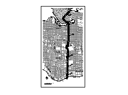 Figure 2
Segments of the Cambie Alignment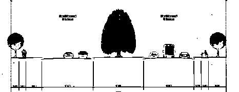
Figure 1. Cambie Boulevard Existing Conditions (RAV Report)
Should RAV be approved, consideration will need to be given to how best to integrate the line into the communities it will serve. The following sections discuss the range of vertical alignment options presented in the RAV Project Definition Report (i.e. where the line is proposed to be underground, at street-level, or above street level) and the implications for community fit and urban design.
A key issue in determining compatibility is the proximity of the line to residential uses. Options for the line in the downtown would not affect residential uses, with one exception. A surface Granville-Robson alignment would pass several mixed-use buildings on Robson and future residential development sites between BC Place Stadium and the Cambie Bridge. Up to 800 future residential units could be affected by this alignment. Outside the downtown, there are 218 residential properties along Cambie Street in the section where the RAV line might, in the worst case, be visible to residents (King Edward Avenue to the Fraser River). If all or part of the line in this section is built on the surface, it will either run down the centre of the Cambie Heritage Boulevard or along either side.
Cambie vertical alignment options
Figures 2 and 3 summarize the vertical alignment in Vancouver of each alternative included in the RAV Project Definition report. Each vertical alignment option is represented by a different pattern in Figure 3. The first alternative for each system type (fully or partially grade-separated) maximizes underground operation. Each successive alternative incorporates increased at-grade or elevated operation.
Alternative 4 is an exception as it places the system in a trench in the south part of Cambie Street, where alternatives 2 and 3 have it elevated. It is possible that the final alignment selected could use some combination of the alternatives illustrated.
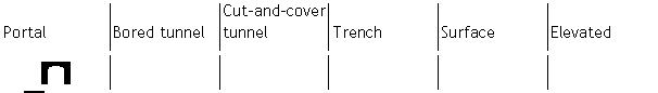
Figure 3 Vertical Alignment Options from RAV Project Definition (refer to Figure 2 for Alignment Segments)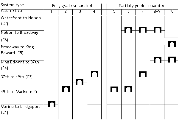
Note: Alternatives 8 & 9 have been combined as they are the same in Vancouver. Alternative 10 follows a different route than the other options. It would operate on the surface along Granville Street from Waterfront Station then turn on to Robson. It would become elevated east of Beatty Street, cross over False Creek on a new bridge immediately east of the Cambie Bridge, and remain elevated until 8th Avenue where it would enter a tunnel and station at Broadway.
Community Fit Issues by Alignment Type
As illustrated in Figure 3, a range of vertical alignment options is under consideration by the RAV project. Each type raises issues of integration into the community as well as specific concerns given unique circumstances in the Downtown and along the Cambie corridor.
Tunnels
There are two basic ways of constructing tunnels - by boring and by cut-and-cover methods. The illustration below (Figure 4) is taken from the RAV Project Discussion Guide, and shows a cut-and-cover tunnel under the Cambie median. This section discusses the general issues concerning these two methods of construction.
Bored Tunnel
Bored tunnels are being considered by the RAV project to go under the narrowest, heavily-trafficked portion of Cambie Street. Two tunnels are required, one for each train direction. All but one alignment option would extend these well into the downtown while others extend them south of King Edward Avenue.

Figure 4 Tunnel Cross-Section (RAV Report)
Of all alignment types, bored tunnels have the least effect on the surface. Consequently, bored tunnels are used where constructing the line on or from the surface would be either impossible or cause unacceptable disruption. Bored tunnels are created using a Tunnel Boring Machine (TBM) that excavates a cylindrical hole in the earth. The hole is then lined with concrete or steel to provide structural integrity. Bored tunnels are the most expensive form of construction and require suitable ground conditions, and so may not be practical or affordable throughout an alignment. Key observations include:
1. The tunnel must be relatively deep, making stations more expensive and more time-consuming for passengers to access.
2. Evidence of the tunnel's presence between stations is limited but would include vent shafts or emergency exits depending on the distance.
3. The visibility of the line at stations could be limited to small-scale entrances giving access to escalators, elevators and stairs connecting to the platforms.
4. Suitable sites must be found during construction to assemble the tunnel boringmachine and to remove large volumes of excavated material. This activity would be intensive and potentially disruptive. An ideal site (e.g. False Creek, Fraser River) would permit excavated material to be barged, rather than trucked away.
5. Disruption during construction would be limited to the sites where the TBMs are assembled and removed, locations where excavated material is removed, and station and emergency exit/vent shaft locations.
All of the RAV options propose a bored tunnel under Cambie Street between 8th Avenue and King Edward, and in some options further south, due to the traffic and land use difficulties associated with other alignment types. All options except one extend this tunnel under False Creek and into downtown for the same reasons, as well as to serve to the Yaletown/Downtown South area.
Cut-and-Cover Tunnel
Cut-and-cover tunnels are under consideration by the RAV Project for the Oakridge area and for Granville Street downtown. They are built from the surface by excavating to the required depth and width, pouring concrete "boxes" to accommodate the rail tracks and trains, then restoring the ground surface above. They can be built where surface or elevated operation is not desired and where the disruption during construction is considered acceptable. While cheaper than bored tunnels, they are more expensive than surface or elevated options. Other observations include:
· The tunnel can be relatively shallow, making stations relatively convenient to access and less expensive to construct.
· Evidence of the tunnel's presence between stations is limited but would include vent shafts or emergency exits depending on the distance.
· The visibility of the line at stations could be limited to small-scale entrances giving access to escalators, elevators and stairs connecting to the platforms.
· Excavated material must be trucked from the construction site.
· As the ground must be fully excavated, any surface features, such as trees, must be removed. If this construction technique were used on Cambie, as some options propose, it would result in the loss of trees and landscaping if the tunnels were built under the median. Construction under traffic lanes would disrupt traffic during construction but would preserve the boulevard. The consequences on local businesses during construction would be substantial in either option, but more severe if the tunnel is placed below the traffic lanes as vehicular access would be curtailed and construction would be closer to businesses.
· In the downtown, a cut-and-cover tunnel could require the closure, or rerouting at a lower elevation, of the underground pedestrian connections between Pacific Centre, Vancouver Centre, and the Hudson's Bay Company department store.
Cut-and-cover options in the RAV proposals are limited to the section between 37th and 49th, and perhaps part of the route under Granville Street downtown. Ground conditions and cost issues are the basis of using cut-and-cover along part of Cambie. For Granville Street, a cut-and-cover tunnel would reduce costs and place the busy downtown stations near the surface, where they would be easier to access.
Portals
A tunnel portal is required wherever a tunnel starts or ends and another form of alignment begins. Tunnel portals can be relatively visually unobtrusive or highly intrusive depending on where they are placed. Key considerations include:
· Where a cut is required to transition from a tunnel to surface or above surface treatment, the obtrusiveness of the portal depends on the length of cut required, which is determined by the ground slope. If the ground slopes up, a train entering a tunnel requires a relatively short cut. If the ground slopes down, a longer cut is required. These transition areas are problematic because of the visual effects of retaining walls and the barrier effect that they create for pedestrian and road traffic.
· A tunnel portal placed in the middle of the street would be very difficult to mitigate. Portals are easier to mitigate where they can be incorporated into buildings or where a station can be used to mask the portal itself (e.g. Stadium SkyTrain station).
At least one tunnel portal is required under all RAV options and it would be on Cambie Street somewhere between King Edward and 63rd Avenue, depending on where the RAV line surfaces. A portal in a traffic lane south of 49th would be relatively less intrusive because the slope down to the Fraser River helps reduce the length of cut required. A portal in the median of Cambie would take space from the Heritage Boulevard.
North of 37th Avenue, the slope of the land suggests that a portal would be very intrusive because of the slope up from False Creek. Some options propose a portal on Granville Street downtown, between Nelson and Smithe streets. This would be very difficult to mitigate because of its position in the middle of a downtown block and the constraints imposed by the relatively narrow street width.
Trench
The vertical alignment of a trench is slightly below grade and open to the sky, as shown below in an illustration from the RAV Discussion Guide.

Figure 5 Trench Cross-Section (RAV Report)

Figure 6b Surface Cross-Section - at centre of median (RAV Report)
Operating rapid transit in a trench in the middle of Cambie Street between 49th and 63rd Avenues is identified in one option. This would permit cost-saving at-grade construction of an automated system (like SkyTrain) in this segment. A trench alignment would be intrusive and akin to an extended version of the cuts required for tunnel portals. Key observations include:
· Most of the trench would be shallow enough that the tops of trains would be above ground level. The trench would have to be deepened in places where vehicle or pedestrian crossings are provided.
· Technologies, such as SkyTrain, use a live electric rail for their power supply. For safety, the edges of the trench would have to be fenced to prevent people and objects from entering the trench. Such fencing would need to be secure and could be visually obtrusive if not carefully screened.
· The likely limited distribution of crossings of the trench, and the need for secure fencing, would make it a physical and visual barrier through the community.
· Noise from the transit system would be partially contained within the trench, although the hard surface walls would act to reflect, rather than attenuate, sound.
· A trench type alignment would significantly reduce the width of the Heritage Boulevard. Detailed design would need to determine if it would be possible to locate the trench on one side of the boulevard but local impacts would be inevitable.
Surface
The RAV Project is considering options for surface alignments along Cambie south of King Edward and also along Granville and Robson streets downtown. Surface operation on the Cambie median could start at King Edward, 37th, or 49th Avenues. The RAV Discussion Guide illustrates two approaches for surface alignments, one on the outside of the Cambie median and the other in the middle of the median, as shown in the two figures below.
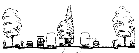
Figure 6a Surface Cross-Section - at side of median (RAV Report)
Surface operation in the corridor would require the use of a partially grade-separated system (i.e. not automated). An overhead contact wire system would supply power to the trains, taking the place of the track-level power rails used by fully grade-separated systems. Surface operation raises issues around integration into traffic and community fit. Considerations include:
· Crossings of streets and paths need to be controlled to prevent trains, vehicles and pedestrians from colliding. In some cases it may be possible to integrate the train operation into the traffic signal system with little effect on vehicle movement. At complicated intersections with high turning volumes (e.g. Cambie and 41st), this may be problematic.
· Collisions on surface systems in other cities are usually the result of motorists or pedestrians disobeying signals or going around crossing gates. Safety systems should be designed, as much as possible, to prevent this from occurring.
· The design of the system could contribute or detract from the street environment. A system using attractively designed low-platform stations, an unobtrusive overhead contact wire system and a well-designed track (e.g. grass between the rails) could blend in with the street environment. Conversely, a system using high-platform stations, an overhead contact wire system with abundant poles and wires, and exposed ballast (large gravel) between and to the sides of the rails would be obtrusive.
· The level of fencing on surface segments would need to balance restricting access with aesthetic considerations. As the system would not be automated, an acceptable balance should be easier to achieve. Fencing would not be required in areas of low-speed operation (e.g. downtown streets).
· Passengers enjoy being able to see their surroundings. This can be an advantage to businesses that would be invisible from an underground system but a disadvantage to residents who may have privacy concerns.
· Noise issues would need to be considered in track and vehicle design to minimize the noise received by residents.
Surface alignment issues specific to the downtown include:
· The Downtown Transportation Plan identified an all-surface alignment on Granville Street, from Waterfront Station to the Granville Bridge, as the only surface option that would be appropriate for a regional-scale system such as RAV.
·
Downtown streets are generally actively used and there is little room for new uses without displacement. A surface system on Granville could require moving the bus services now on Granville to Howe and Seymour streets, likely requiring changes to those streets, such as bus lanes and parking reductions that would affect adjacent properties and businesses. Not relocating the buses could result in sidewalk widths too narrow for current pedestrian demands, and too narrow for the increased pedestrian traffic that will come with a RAV line and growth in the downtown.
· Surface operation on Granville could require a portal between Nelson and Smithe. This could alter pedestrian and vehicular access, and affect adjacent properties.
· One alignment option suggests the use of Robson Street between Granville and Beatty. This would require a significant reconfiguration of this street with reductions inparking and vehicular access.
·An additional bridge over False Creek would be challenging in terms of land available for access on both sides of the Creek, view impacts, and the difficulty of integrating a new bridge into the street system on either side of the creek.
Surface alignment issues specific to Cambie Street include:
· The Cambie Heritage Boulevard. The tracks could either go down the middle of the boulevard, with the existing trees removed and new trees added between the tracks and road traffic, or they could run at the edges of the boulevard, preserving the trees but providing less screening of the tracks from residents. Some combination of these options could be used to preserve the most significant trees while providing better screening in other areas.
· If the tracks took over an existing traffic lane, on-street parking would likely be lost, at least during rush hour.
Elevated
All proposed alignments include a section of elevated guideway south of 63rd Avenue for the RAV line to cross over Marine Drive and connect to a new bridge over the North Arm of the Fraser River. In some alternatives, the RAV Project is considering elevated alignments on Cambie south of 37th; and between Robson and Beatty, and Cambie and 8th. The Project's Discussion Guide shows two alternative elevated alignments for the Cambie Boulevard, as shown below.

Figure 7a Elevated Profile - sides of median (RAV Report)

Figure 7b Elevated Profile - centre of median (RAV Report)
Elevated alignments are the most difficult to adapt to their surroundings but are the cheapest way to construct a fully grade-separated system. It may not be possible to provide sufficient mitigation to make an elevated system acceptable. Key considerations include:
· Elevated structures are visually obtrusive and cast shadows. Vegetation could be planted below an elevated guideway but would not conceal the structure, just soften some of its appearance.
· An elevated system would significantly alter the appearance of the Heritage Boulevard. Some trees would need to be removed to provide space for support columns and to prevent them from interfering with the guideway over time.
· Elevated stations are especially dominating of their surroundings. As evidenced by the Millennium Line stations, even imaginative architectural designs can not conceal the visual bulk of the stations.
· Crossing opportunities under an elevated structure are not constrained, an advantage for vehicular and pedestrian traffic.
· While passengers on elevated systems enjoy expansive views, this is at the expense of the privacy of residents at or below the elevation of the guideway.
· Transitions between elevated structures and other forms of alignment create physical and visual barriers.
· Sound can travel some distance from an elevated structure and affect many properties, although this can be reduced with acoustic barriers near track-level.
· If an elevated structure travels across properties, their development potential would be reduced in order to provide adequate separation between the trains and other uses. For example, City guidelines developed for road bridges mandate that residential towers be at least 30 metres (horizontally) from bridges. This guideline could be applied to elevated rail lines. Creative design, such as integrating the guideway into a building, as done by the VanCity tower at Main and Terminal, could help alleviate but not eliminate this concern.
· An elevated structure between Robson and Beatty, and Cambie and 8th could affect 800 future residential units and the streetscape design of approved developments.
Summary and Conclusions
A range of vertical alignments are being considered by the RAV Project, each of which raises particular concerns surrounding their integration into adjacent neighbourhoods. Some alignment types, such as bored tunnels, have relatively little impact except during construction and then only at certain sites. At the other extreme, elevated guideways are highly visible to adjacent communities and are difficult to integrate. Surface alignments can be integrated where good design practices are followed and where they do not have unacceptable effects on other traffic. Should a RAV line be built, it will likely use a mix of alignment types and these must be chosen based on their ability to fit into the communities served, as well as cost considerations.
The potential for development around stations would seem to vary little between the alignment types, based on the experience in Greater Vancouver to-date. There has been extensive development along existing SkyTrain lines adjacent to at-grade, elevated andtunnelled portions of the lines. The developments at Collingwood Village and Metrotown suggest that even elevated lines may not be a significant obstacle to redevelopment if new development is designed to tolerate an elevated system.
III. Background on the Cambie Heritage Boulevard
Urban Design
In 1929, Harland Bartholomew completed the first plan for the City of Vancouver. It incorporates principles of the English Garden City and ideals of the US City Beautiful movement, in particular the combined design and landscape concept of "Pleasure Drives". The plan identifies the city's need for "...a continuous chain of pleasure drives developed for the primary purpose of accommodating the increasing thousands of vehicles driven for pleasure." Further, it states that "It is time the city considered giving those who find great enjoyment in these leisure-time and holiday tours a special route touching many of the larger parks and having qualities not possessed by ordinary city streets."
Drawing on an established tradition in cities such as New York, Chicago and Washington DC, the plan calls for a system of parkways and boulevards, which would encircle the city at its shoreline and bisect the city in both north-south and east-west directions. The plan called for "long, well-planted and developed parkways and boulevards touching, at intervals, parks of different types." Specifically, the plan identifies Cambie Street as a "Cross City Boulevard," and one of the most important direct routes from the business centre of the city, skirting Little Mountain Park (now Queen Elizabeth Park), to the Fraser River. The plan includes suggested right-of-way cross-sections which reflect the design principle of a roadway bordered on both sides by a landscaped and treed boulevard. Other similarly treated streets in the city include Stanley Park Drive, King Edward Avenue, Boundary Road, and portions of Marine Drive.
Landscape Features
The Bartholomew Plan, and the subsequent 1947 Major Street Plan, set out the overall urban design and landscape framework for Cambie Street between King Edward Avenue and Southwest Marine Drive. In accordance with these plans, Cambie Street has been developed with a wide right-of-way (ranging from 140 to 200 feet), with two roadways (northbound and southbound) separated by a wide central median and bordered on either side by civic boulevard. Cambie's central median and civic boulevards (approximately 40 blocks long) are heavily treed with over 1,000 shade, ornamental and coniferous trees. In concert with the 1,500 trees in the adjoining Queen Elizabeth Park arboretum, Cambie is one of city's finest examples of living urban forest and heritage landscape.
Within the overall heritage landscape of the Cambie Street right-of-way, the landscape elements and/or plantings of special interest include:
· The ornamental trees that are now 50 to 75 years old along the Cambie Heritage Boulevard and in the Queen Elizabeth Park arboretum are almost all the vision and work of W.C. (Bill) Livingston, the former Superintendent of Parks for Vancouver.Beginning in 1938 as a Park's Foreman and over his next 36 years with the City, Livingston is credited with the development of more than thirty of Vancouver's beaches, recreational grounds, playing fields, display gardens, and treed streets and boulevards.
· The Cambie Heritage Boulevard's tree legacy began with its northerly eight blocks, with the planting of the rare golden yellow-leaved English elm, `Vanhoutei' in 1936 and the `Giant Redwood' or `Bigtree' from California's Sierra Nevada Mountains in 1938; some of these trees are approaching 200 feet in height.
· The repeated groups of Japanese flowering cherries, `Pink Perfection' and Yoshino cherry, as well as double-white `Shirofugen' and vase-shaped pink `Kwanzan', appear as the theme flowering trees along the Boulevard.
· The Boulevard and the adjacent park arboretum are also unique in having two West coast conifers, the Falsecypress', used as ornamentals and grouped in threes throughout.
· Finally, the Boulevard's collection of three species of dogwood trees is of special importance, not only because it is the Provincial flower, but also for its rare and discouraged use as a street tree - nonetheless, these trees have thrived.
IV. Land Use Information for Central Broadway
To respond to the RAV proposal, Council requested information comparing the north-south rapid transit route to the Western Extension of the Millennium Line.
Planning for the Millennium Line concluded that an extension from VCC station to Granville Street, and eventually UBC, was the top priority for the completion of the line. This is because, amongst other things, Broadway is one of the busiest transit corridors in the region with over 50,000 transit users daily. The second largest job centre in the region is located along Broadway between Main and Arbutus. Approximately 60,000 jobs, with the capacity for an additional 30,000 jobs by 2021, are found in this section. It also contains 47,000 residents with capacity for an additional 7,000 by 2021. It is heavily used by vehicular traffic with over 40,000 vehicles per day.
In order to serve the development capacity in the Broadway corridor, bus service would need to increase but this would not address increasing vehicular congestion and bus volumes would approach saturation. Given the job growth potential in the Broadway corridor, rapid transit is critical to facilitating and serving this growth efficiently. Accelerating this requirement is Broadway's role in absorbing "spill over" job growth from the downtown. The employment capacity in downtown of an additional 40,000 employees could be reached within 15-20 years.
* * * * *