Vancouver City Council |
ADMINISTRATIVE REPORT
Date: March 19, 2003
Author/Local: Ian Fisher/604-873-7172
Melina Scholefield/
604-873-7916
RTS NO.02967CC File No.5560-1
CS&B: April 10, 2003
TO:
Standing Committee on City Services and Budgets
FROM:
General Manager of Engineering Services and Director of City Plans
SUBJECT:
Whole Route Analysis: Clark Drive-Knight Street Corridor
RECOMMENDATIONS
A. THAT Council direct staff to proceed with the Clark-Knight Corridor Whole Route Analysis, as described in this report, including the Consultation Plan described in Appendix B; and
B. THAT Council approve funding of $120,000 ($84,000 in 2003 from Contingency Reserve and $36,000 in 2004) for the Clark-Knight Corridor Whole Route Analysis and for a City-wide noise survey.
C. THAT Staff continue to pursue cost sharing opportunities with senior governments.
COUNCIL POLICY
On May 27, 1997 Council approved the Vancouver Transportation Plan, which proposed goods movement initiatives for Knight Street, subject to a full cost accounting and whole route analysis of the corridor.
Council approved Community Visions for Kensington-Cedar Cottage on July 28, 1998, and for Victoria-Fraserview/Killarney and Sunset on January 15, 2002. These Visions contain a number of directions regarding transportation and housing along Knight Street.
The Urban Noise Task Force suggested Knight Street as one of four top priority streets for noise mitigation. This recommendation was supported by Council when the Task Force's report was received May 27, 1997.
PURPOSE AND SUMMARY
The purpose of this report is to introduce key land use, transportation and environmental issues along the Clark Drive-Knight Street Corridor and seek Council approval for a Whole Route Analysis (WRA) to address these issues. The purpose of a WRA is to examine the function and operation of an entire route, in a manner that recognizes its land use and transportation roles, and the consequences for local residents, the goods movement industry, transit users, pedestrians, commuters and businesses.
The Clark-Knight corridor faces unique challenges that stem from its role as the City's primary goods movement arterial, and the predominantly residential land uses along it. The 3,000 trucks using the corridor each day make Clark-Knight the most important truck route in the City.
However, this role has resulted in livability concerns for the 2,800 people who live directly on the corridor and those nearby. As well, safety for pedestrians, cyclists and vehicle occupants is a pressing issue. The corridor's heavy traffic volumes combined with high collision rates are affecting goods movement. The long-standing concerns of residents and road users led to a recommendation in the 1997 Transportation Plan that staff undertake a WRA to assess the issues and develop options for improvement.
The work program described in this report takes a holistic approach to land use, transportation and environmental factors affecting the corridor. Its initial stage involves issues analysis by staff and consultants, followed by a public process of evaluating options for corridor improvements.
The outcome will be a Corridor Plan. The Plan will recommend short and medium-term improvements and future projects and policy directions that will help achieve the directions set out in the Transportation Plan and the Community Visions. The Plan will also recognize that Clark-Knight will continue to be a primary arterial and goods movement corridor in the City. Work will be undertaken using existing staff resources. The estimated cost for this project, primarily for the public process and consultant work, is $120,000. Of this total, $60,000 is for a City-wide noise survey that will provide information of a much broader interest than this one corridor.
BACKGROUND
The 1997 Vancouver Transportation Plan recommends improvements to Knight Street to facilitate goods movement, subject to a WRA of the Clark-Knight corridor. The WRA will assist the City in better integrating current and future land use planning with transportation decisions for the corridor.
The Clark-Knight corridor is a major traffic artery in Vancouver, extending eight kilometres from Burrard Inlet to the Knight Street Bridge across the Fraser River. North of 13th Avenue, the corridor follows Clark Drive. South of 13th, it follows Knight Street.
The corridor carries 38,000 to 55,000 vehicles per day, with the heaviest volumes occurring near the Knight Street Bridge. Trucks comprise nearly 9% of daily traffic volumes, the largest proportion for any City arterial. This is due to the corridor's strategic position linking the Port and industrial areas on the north side of the City with industrial areas in south Vancouver, Richmond, Delta, Surrey, and beyond via Highways 91 and 99.
The historical development of land uses and transportation infrastructure has shaped the corridor. Unlike Main, Fraser and Victoria, Knight was never a streetcar route and developed with lower intensity and fewer commercial land uses than these nearby arterials. Development along Knight consists mainly of single-family homes with small-scale commercial uses at major intersections. Two elementary schools (Queen Alexandra and Sanford Fleming) were built on the street in the early 1900s, long before it became a major arterial.
The corridor's present function was established in the 1929 Vancouver Major Streets Plan, which designated it as a six-lane arterial. However, it was not until the opening of the Knight Street Bridge in 1974 that the corridor became a prominent regional roadway. The subsequent openings of the Alex Fraser Bridge and the Richmond Freeway (Highway 91) further reinforced Knight's role as a major regional goods movement and traffic arterial. Clark-Knight is included (except for the few blocks north of Hastings Street) in TransLink's Major Road Network (MRN).
Today, the corridor's transportation function and the predominantly residential land uses along it create livability issues for residents and safety concerns for pedestrians, cyclists and motorists. Like most Vancouver arterials, the street right-of-way is fully used, limiting opportunities for roadway changes if traffic capacity is to be maintained.
Over the past year, staff have consulted with stakeholders, documented conditions on the corridor and identified problems and opportunities. This work is summarized in a Background and Issues Paper (on file in the City Clerk's office and available online at www.city.vancouver.bc.ca/knight) and is the basis of the work program discussed in the following section. Guiding policy directions from the 1997 Vancouver Transportation Plan and the Kensington-Cedar Cottage, Sunset and Victoria-Fraserview/Killarney Community Visions are summarized in Appendix A.
DISCUSSION
The work program to address the key land use, transportation and environmental issues identified in the Issues Paper has three stages:
· Stage 1: Further Study and Analysis of Issues;
· Stage 2: A Process for Working with Stakeholders; and
· Stage 3: Report to Council with Recommendations for a Corridor Plan.Stage 1: Further Study and Analysis of Issues
The following sections detail the questions related to land use, transportation and the environment that the WRA will address through further technical studies and stakeholder discussions.a) Land Use
Land use issues focus on industrial areas and the needs of the Port, housing and redevelopment, and parks and community centres:
Topic
Key Questions and Issues
Industrial Areas & Vancouver Port Vancouver
What would encourage more businesses with close ties to Downtown and the Port to locate in these areas?
Housing & New Development
Within the framework of CityPlan and the Community Visions, how can more livable housing be developed along Knight Street?
Parks & Community Centres
How can park edges be designed to reduce traffic noise, while maintaining safety, access, mountain views, and existing park facilities?
b) Transportation
Transportation issues focus on general traffic, safety, goods movement, transit, cyclists, pedestrians, school crossings and the street environment:
Topic
Key Questions and Issues
General Traffic
There are locations along the corridor where congestion is an issue. Given the physical limitation of the road right-of-way and the priority needs of pedestrians, cyclists, transit and goods movement ahead of private vehicles, improvements for general traffic must be balanced with the needs of other road users. What measures could ease congestion and neighbourhood short-cutting, particularly with continuing traffic growth along the corridor?
General Traffic Safety
Safety is a pressing issue. Conditions at 49th, 33rd and Kingsway, in particular, require further investigation to understand how collision frequency and severity could be reduced. Reducing conflicts related to on-street parking should also be investigated.
Poor driver behaviour including aggressive driving, speeding and red-light running, although not unique to this corridor, is an issue. How can infrastructure and streetscape design, traffic controls, education and enforcement be combined to discourage these risky behaviours?
Goods Movement
Given Clark-Knight's importance to local and regional truck networks, how can travel conditions for trucks be improved, particularly during the non-peak periods when truck volumes are greatest? What measures could be considered to improve safety and travel time reliability?
Transit
Transit ridership on Clark-Knight is relatively low. How can the safety, comfort and convenience of transit travel - both on transit and in the journey to and from transit - be improved? What route and service changes would encourage greater transit use?
Cycling
The Clark-Knight corridor is not conducive to cycling. What alternative routes would provide access to major destinations on the corridor and to the existing bicycle network? What options exist for improving cyclist safety and amenities along the corridor, particularly near commercial areas, parks, schools and community centres?
Pedestrian Activity
Clark-Knight has narrow and often unkempt boulevards, sidewalks close to traffic, missing curb ramps, heavy traffic, noise, and a high concentration of diesel vehicles, making for an undesirable pedestrian environment. How can pedestrian safety, comfort and accessibility be improved? How should improvements be prioritized?
School Crossings
There is a need to look for improvements in access for the schools whose catchment areas cross the corridor. What opportunities are there for improving pedestrian crossings to the schools on the corridor?
Street Environment
The look and feel of the corridor is that of an urban highway; it lacks the street animation found on most other City arterials. How could visual interest be added to reduce the impact of heavy traffic and make the street less conducive to speeding?
c) Environment
Environment issues focus on noise and air quality:
Topic
Key Questions and Issues
Noise
How can new building design be adjusted to improve residential livability along the corridor? Should new dwellings be required to meet noise guidelines? Are noise fences appropriate and/or workable in the corridor?
Air Quality
How can the City work with other agencies and levels of government to address air quality issues?
Most of these issues require in-depth study to develop and assess options for improving conditions. While much of this work will be done by City staff, funding is requested for a city-wide noise study that will provide a basis for dealing with noise issues on Clark-Knight and arterial streets in other City neighbourhoods. The results will also be particularly applicable to the growing number of mixed-use, residential-above-commercial developments on arterials in the City. The proposed noise study has two components:
· City-wide survey of traffic noise levels - Noise conditions at about 60 city locations will be assessed, including several locations along the Clark-Knight corridor. This will provide a comparison of noise conditions on arterials serving different functions (e.g. with and without trucks, major transit routes, secondary arterials) and associate the noise levels with traffic volumes. This work will help illustrate the effects of truck and other types of traffic on the local noise environment.
· Noise source identification - The objective of noise source identification is to understand the composition of traffic noise in a variety of situations. The study will identify the number and nature of highly intrusive noise events in a variety of arterial conditions. The study will also compare recorded noise levels and the perceived loudness of the noise sources. The conclusions will inform the development of appropriate noise control strategies for various arterial conditions.
The proposed noise study will also complement a concurrent City initiative to develop a Homeowner's Guide to Noise Reduction. This guide will provide residents with ways to reduce the impacts of street noise on their homes. In addition, a consultant review of noise fences, completed in 2001, will be reported on through the WRA project.
Other City projects which relate to the Clark-Knight corridor include a False Creek Flats rail study and the Kingsway and Knight Neighbourhood Centre project. City staff are also involved in a safety review of the corridor being conducted by ICBC.
Stage 2: A Process for Working with Stakeholders
Stakeholders want the City to take an integrated approach to public involvement on this project. Perspectives and priorities of the Vancouver Port Corporation, the BC Trucking Association, ICBC, TransLink, the Police, community groups, and individual residents are likely to be diverse and in some cases divergent. Representatives of these interests will be brought together in an Advisory Committee to advise the study, monitor the public process and comment on options. This will assist stakeholders in developing a greater appreciation for and consideration of each others' interests and finding mutually agreeable solutions. A facilitator will assist the consultation program.A one-year project schedule is proposed. The process is designed to be inclusive and efficient, recognizing the time that many residents have already invested in the Community Visions, as well as the head-start provided by the Vision Implementation Committees.
The public process will begin this May and will include newsletters and advertising, an introductory open house, community events and several advisory committee meetings.Special efforts will be made to reach out to the large non-English speaking population along the corridor. Staff will also meet with groups to address local issues, such as access to schools. The process, time lines, and roles and responsibilities are detailed in Appendix B.
Stage 3: Report to Council with a Corridor Plan
It is anticipated that the Corridor Plan will include two types of recommendations:· Short and medium-term improvements that can be implemented through existing City programs and processes. Examples include signal timing modifications, pedestrian safety measures, safety improvements and landscaping.
· Projects and policy directions which require a level of analysis and staff resources beyond the scope of the Whole Route Analysis. Examples include rezoning along the corridor to require new housing to meet noise standards or developing and evaluating goods movement priority measures.
FINANCIAL IMPLICATIONSThe budget for the Clark-Knight WRA project is $120,000. The requested sources of funding are $84,000 from Contingency Reserve in 2003 and $36,000 in the 2004 Operating Budget. As detailed in the table below, the bulk of the budget items are for public consultation and for a noise consultant.
Item
Budget
PUBLIC EVENTS - open house/community events, Advisory Committee mtgs
$46,500
Newsletters (4 x 6,500 households/businesses)
$22,000
School flyers (4 x 1700 students)
$1,800
Advertising
$8,300
Open house (1) and community event (2) translation and staffing
$5,700
Catering
$700
Facilitation
$8,000
CONSULTANT FOR NOISE STUDY
$60,000
REPORT PRODUCTION
$2,500
Sub-total
$109,000
Contingency (approx. 10%)
$11,000
TOTAL
$120,000
Staff will pursue cost sharing opportunities for the WRA with the federal government, which has indicated an interest in improvements for Clark-Knight as part of their Border Infrastructure Funds program. In addition, there may be some opportunities for cost-sharing the noise study with the Vancouver Coastal Health Authority.
CONCLUSION
The Clark-Knight corridor provides a critical transportation function for the City and the region. However, the interface between this transportation function and the predominantly residential land uses is problematic. The land use, transportation and environmental issues identified for the corridor are closely linked and an integrated approach is needed to develop solutions to address them. The Whole Route Analysis detailed in this report provides a framework to develop workable solutions.
* * * * *
APPENDIX A
Whole Route Analysis:
Clark-Knight Corridor
GUIDING POLICY DIRECTIONS
The 1997 Vancouver Transportation Plan and the Kensington-Cedar Cottage, Sunset, and Victoria-Fraserview/Killarney Community Visions provide directions to guide the WRA project including:
1. 1997 Vancouver Transportation Plan
· Growth in demand for transportation will be accommodated by improving alternatives to the car, primarily transit but also walking and cycling;
· Overall road capacity will not be increased;
· The car will continue to be the major form of transport for people travelling outside their neighbourhoods;
· The existing truck network will be largely maintained. Improvements in access to the Port of Vancouver and Vancouver International Airport will be pursued; and
· Intersection improvements, such as left turn bays, may be required to improve safety at some intersections. These will be designed so as not to increase capacity and wherever possible will be accommodated within the existing road width. Such improvements will be subject to a full cost accounting to ensure impacts on neighbourhoods are minimised.
2. Community Vision Directions
· Streetscape improvements in Kingsway & Knight area (KCC);
· Improve conditions and safety on Knight Street for residents, pedestrians and transit users (KCC, VFK, Sunset);
· Improve the transit `experience'(KCC, VFK);
· Address access problems to community facilities created by the heavy arterials (KCC);
· There should be on-street parking in shopping areas wherever possible (KCC);
· Small, local shops should line the sidewalks, instead of developments with parking lots in front or buildings without storefronts (KCC);
· Rowhouses, four- and six-plexes and duplexes should be clustered around Knight and Kingsway (KCC). Duplexes should be permitted where they conform with neighbourhood character (Sunset). Duplexes should be permitted where they conform with neighbourhood character, especially along transit routes (VFK);
· Senior's housing should be built near shops, parks and transit; and
· Urban traffic noise should be reduced (KCC).
APPENDIX B
Whole Route Analysis:
Clark-Knight Corridor
CONSULTATION PLAN
The consultation plan for the Whole Route Analysis has been developed from the public processes for the 1997 Transportation Plan and the Kensington-Cedar Cottage (KCC), Victoria-Fraserview/Killarney (VFK) and Sunset Community Visions. These processes have provided some of the guiding principles and issues for the analysis and thus give the WRA a head-start. Given this background and the WRA team's consultation with stakeholders about a process approach, an inclusive, but time-efficient process is proposed. The public process objectives, process components, time lines and the roles and responsibilities of the various participants are detailed in the following sections.
OBJECTIVES
The objectives of the Consultation Plan are to:
· Include a broad range of stakeholders: residents, goods movement, transit, commuters, schools;
· Target communications and outreach to the most affected parties;
· Reach English-as-a-second-language populations;
· Bring stakeholders with different interests together to discuss issues collaboratively;
· Structure the process efficiently to avoid stakeholder burn-out; and
· Allow for flexibility within the process to respond to the needs of participants, including the City.
PUBLIC PROCESS OVERVIEW
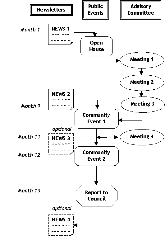
The one-year process will include an Advisory Committee, a series of public events, and regular communications with the public through newsletters and advertising, beginning in May 2003. The process will offer a variety of methods for the public to provide input. Newsletter surveys, open houses, and community events (featuring interactive displays and discussion groups) will be available to encourage participation appropriate to each participant's level of interest and availability. A diagram of the consultation process and associated time lines is on the following page:
Clark-Knight Whole Route Analysis Public Process Diagram
Advisory Committee
The project will have an Advisory Committee, composed of community, commercial and governmental representatives. This group will monitor the project and advise staff on community outreach, as well as providing a creative and critical role in helping analyse and evaluate options. Committee members are expected to have and express opinions that are different from each other, and consensus is not necessarily expected. The committee is advisory to staff and the process and will not make decisions on which proposals are carried forward at the various stages of the project.
The committee is to be composed of 11 to 19 members, as follows:
· 1-2 members from each community along the corridor (Strathcona, Grandview-Woodlands, Mt. Pleasant, Kensington-Cedar Cottage, Sunset, and Victoria-Fraserview/Killarney);
· 1-2 representatives from businesses along Clark Drive and Knight Street;
· 1-2 members from TransLink to represent transit and Major Road Network interests;
· A representative from the Vancouver Port Authority;
· A representative from the BC Trucking Association;
· A representative from the Insurance Corporation of British Columbia (ICBC).
The Advisory Committee will meet four times over the term of the project. Additional meetings will be arranged if there are issues that would best be dealt with by subcommittees. The timing of the full committee meetings will ensure it is kept abreast of input received at public events, and able to contribute to the design and content of subsequent events. Committee members will also be encouraged to attend the public events planned for the study.
Public Events
The following table explains each public event in more detail:
Event |
Purpose |
Open House
|
· Introduce project, process, purpose and staff team;
|
|
Community Event 1 Winter 2004 |
· Present proposals developed by staff based on past public input and consultation with the Advisory Committee; · Identify public priorities; · Translated display panels and staff members with a second language will be present. |
|
Community Event 2
|
· Review draft Corridor Plan proposals and priorities; · Receive public comment on draft plan; · Translated display panels and staff members with a second language will be present. |
Communication with Communities
Communications with resident and non-resident groups will be important to generate interest and maximise participation. For this reason, a newsletter, school flyers and advertising effort is proposed. Advertising will include newspapers with local, regional and multicultural readership. In addition, a feature spot on the Greater Vancouver television program will be pursued.
Up to four newsletters are proposed for distribution to 6,500 residents and businesses within approximately one block of the corridor. Each newsletter will be issued in English and Chinese. The purpose of each newsletter is:
· Newsletter 1 - provide general background on the corridor, describe and outline the process for the Whole Route Analysis, advertise the open house, and highlight some of the key issues. A questionnaire/comment form will also be provided to solicit feedback and recruit Advisory Committee participants.
· Newsletter 2 - outline various options, provide an opportunity for feedback, and advertise the first community event.
· Newsletter 3 (optional) - summarise the draft plan that staff are developing for Council's consideration, provide an opportunity for feedback, and advertise the second community event.
Other communication tools may be substituted depending on the educational needs of the project.
· Newsletter 4 (optional) - Communicate Council's final decisions to participants and the communities along the corridor. Other communication tools may be substituted depending on the educational needs of the project.
Public process participants' roles and responsibilities
The roles of the various process participants are summarised in the following chart:
The Community |
Advisory Committee |
City Staff & Consultants |
City Council | |
Manage the process |
X |
|||
Project monitoring |
X |
X |
||
Outreach |
X |
X |
||
Facilitate events |
X |
|||
Identify Issues |
X |
X |
X |
|
Generate ideas for addressing issues |
X |
X |
X |
|
Develop options |
X |
|||
Detailed analysis |
X |
|||
Review proposals |
X |
X |
X |
|
Indicate a preference for various proposals |
X |
X |
X |
|
Recommend a Corridor Plan |
X |
|||
Approve the Corridor Plan |
X |
![]()