|
|
POLICY REPORT
URBAN STRUCTURE
Date: September 17, 2002
Author/Local: K.Hiebert/604-871-6066
RTS No. 02939
CC File No. 2608
Council: September 19, 2002
TO:
Vancouver City Council
FROM:
Director of Current Planning, in consultation with the General Manager of Engineering Services, General Manager of Parks and Recreation, and the Director of Legal Services
SUBJECT:
CD-1 Text Amendment: Beach Neighbourhood (Area 1B) - 500 Pacific Street Marina
RECOMMENDATION
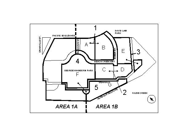
A. THAT the application by Pacific Place Developments Corp. to amend CD-1 By-law No. 7675 (# 366) for Beach Neighbourhood (Area 1B) at 500 Pacific Street to add a marina sub-area, be referred to a Public Hearing together with:
(i) revised plans by Peter Busby and Associates Architects received September 5, 2002;
(ii) the recommendation of the Director of Current Planning that the application be approved, except that the marina moorage area (or footprint) be reduced from 5 022 m² to approximately 2 728 m², the maximum size of the ancillary floating building be reduced from 150 m² to 75 m², the number of floats be reduced from two to one, and the number of moorage berths be reduced from 27 to 13; and
(iii) draft by-law amendments generally as presented in Appendix A which reflect the recommendations of the Director of Current Planning set out in the preceding subparagraph (ii) of this Recommendation A.FURTHER THAT the Director of Legal Services be instructed to prepare the necessary by-law for consideration at the Public Hearing.
B. THAT the Director of Current Planning be instructed to make application to amend the False Creek North Official Development Plan, By-law No. 6650, to add a marina sub-area in Area 1B Beach Neighbourhood, and that the application be referred to the same Public Hearing together with:
(i) draft by-law amendments generally as presented in Appendix C; and
(ii) the recommendation of the Director of Current Planning that the application be approved, but including a reduction in marina moorage area and ancillary marina building size as set out in Appendix C.FURTHER THAT the Director of Legal Services be instructed to prepare the necessary by-laws for consideration at the Public Hearing.
C. THAT the General Manager of Engineering Services and Director of Legal Services be authorized to enter into an agreement with Pacific Place Developments Corp. permitting usage of the water area over a portion of City Road for marina use at a nominal fee.
D. THAT amendments to the Beach Neighbourhood Design Guidelines, as set out in Appendix D, be approved at the time of enactment, including a reduction in the permitted expansion zone in Beach Neighbourhood (Area 1A).
GENERAL MANAGER'S COMMENTS
The General Manager of Community Services RECOMMENDS approval of A, B, C and D.
COUNCIL POLICY
Relevant City Policies, Plans and Guidelines include:
· Central Area Plan, approved in December 1991.
· False Creek North Official Development Plan, approved April 10th, 1990.
· Beach Neighbourhood CD-1 Guidelines (500 and 600 Pacific Street), approved October 21st, 1999.
· False Creek North Policy Statement, approved in August 1988.
· False Creek North shoreline and pedestrian/bicycle concept plans, approved in October 1991.
· Blueways Policies and Guidelines, approved December 1998.PURPOSE AND SUMMARY
This report assesses an application by Pacific Place Developments Corporation (PPDC) to amend CD-1 By-law No.7675 (#366) for Beach Neighbourhood - Area 1B (500 Pacific Street) to add a marina sub-area east of the George Wainborn Park seawall promontory.
This text amendment and a related report amending the Southeast Granville Slopes Official Development Plan represent a coordinated effort by City staff, PPDC, and the False Creek Yacht Club (FCYC) to resolve outstanding marina development and related issues in a way that balances public and private benefits along the waterfront in this vicinity.
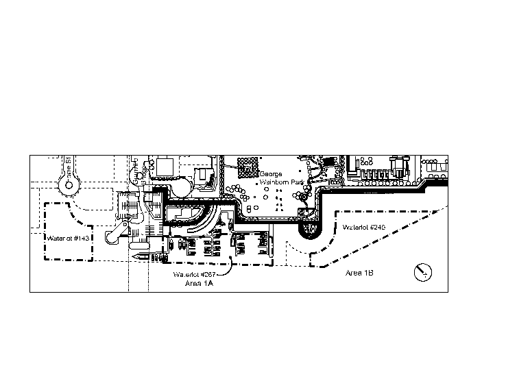
The application proposes that 20 mooring berths or 4 706 m² (50,656 sq. ft.) of water area for marina uses, as permitted by the zoning for Beach Neighbourhood Area 1A, but not yet developed, be relocated a very short distance to the east to create a separate marina in Beach Neighbourhood Area 1B on a waterlot owned by PPDC (Waterlot #249). PPDC's proposal also calls for an additional 7 mooring berths or 316 m² (3,402 sq. ft.) of water coverage for marina uses to accommodate the new marina for a total of approximately 27 mooring berths, depending on the size of boats (5 022 m² footprint). One floating building for ancillary marina use is proposed.
Figure 1: Transfer of Marina Area from Area 1A to Area 1B, Beach Neighbourhood
Additionally, approximately 600 m² (6,458 sq.ft.) of water coverage for marina uses on Waterlot #267 (between the existing FCYC docks and the Harbour Headline) is required to accommodate extensions to the FCYC docks to provide five dedicated transient moorage berths.Staff recommend a revised marina footprint and configuration as noted in recommendation A(ii) that: (see Figure #2)
· removes the second `spine' of the proposed marina, reducing the marina footprint,
· reduces the size of the ancillary floating service building from 150 m² to 75 m², and
· allows for 14 additional berths, plus the 5 dedicated transient moorage berths. These are provided in the expansion area approved in 1999, between the Harbour Headline and FCYC docks and to the east of the FCYC docks at the foot of George Wainborn Park.Figure 2: Staff Proposal
If this proposal is approved, the primary benefit for PPDC will be the approval of a small marina separate from FCYC. FCYC will gain a longer security of tenure with a ten yearlease on the waterlot they currently lease from PPDC. This rezoning is being processed in conjunction with an amendment of the Southeast Granville Slopes (SEGS) Official Development Plan to make the FCYC's existing berths on the west side of the marina (Waterlot #143) a permanent use. (See: Figure 3: Waterlots).Figure 3: Subject Waterlots
Public benefits proposed by the applicant include the following:
· significant increased views of open water from George Wainborn Park,
· increased moorage in False Creek, and
· five permanent visitor moorage berths at FCYC docks, each available 365 nights per year for visiting boaters (total 1,825 visitor moorage nights per year).Staff are also recommending the applicant (PPDC) provide alterations to the public ferry dock planned for David Lam Park to make it wheelchair accessible.
In addition, the application would secure the following public benefits identified as part of the Beach Neighbourhood Area 1A rezoning (1999) for the expansion of 20 berths adjacent to the existing FCYC:
· an identifiable public walkway (public right-of-way) across the FCYC site, under the Granville Street Bridge, closer to the water than the existing walkway/bikeway,
· an information centre, including a moorage referral service, available to visiting boaters, and
· a public pump-out station, laundromat and toilet facilities for visiting boaters.The application has presented staff with the challenge of assessing the considerable public benefits offered by the proposal against the view impacts of the relocated marina. The FCN ODP states that marinas should be "of a size, number and location to maintain street-endviews and key long views across the water". Although the new location of the marina opens up views in front of George Wainborn Park it also impacts long open water views to the far shore to the southeast.
People attending the Open House held August 19, 2002 indicated general support for the proposal (62% of received comment sheets were in favour). However, some have raised objections to the new marina location because of potential view impacts, increase in water coverage for marina uses, and environmental impacts associated with marinas generally.
The application was revised to respond to staff and public concerns. The revised application as presented in Figure #6:
· reduces the number of accessory marina buildings to one;
· proposes a mix of small, medium, and large boats;
· locates large boats (30 m/100 ft. long) away from the George Wainborn park and seawall promontory; and
· proposes a configuration that allows for some view penetration through to open water.The revised marina configuration still affects long views across the water to the southeast, particularly from the seawall promontory at George Wainborn Park by putting boats in the sightlines of long views. Staff are recommending several conditions to further reduce the marina footprint and strike a more appropriate balance between public and private benefits.
The Director of Current Planning recommends that the application be referred to Public Hearing and approved subject to conditions. He also recommends that he be directed to make application to amend the False Creek North Official Development Plan to include the proposed marina on the illustrative site plan, and that this application be referred to the same Public Hearing.
BACKGROUND
Site and Surrounding Context: The site is within Area 1B of the False Creek North (FCN) Official Development Plan (ODP). It is located south of Pacific Street between the Granville Bridge and David Lam Park. (see Figure 4)
Existing Zoning and Development: The current zoning for Beach Neighbourhood 1A 600 Pacific Street (CD-1 No. 8109 (#399)) includes marina uses. The FCYC marina is currently in this location under a lease arrangement with PPDC. In 1999, Council approved the expansion of the marina of another 20 berths (4,706 m²/50,656 sq. ft.) out to the Harbour Headline and further east beside George Wainborn Park by approximately 47 m (154 ft.) up to the Park promontory. Accordingly, the CD-1 Guidelines for Beach Neighbourhood showapproximately 70 boat berths (50 existing plus expansion for 20) extending east from Granville Bridge (see Figure 5, Current Approved Marina Plan). The False Creek North Official Development Plan includes a marina footprint in this location.
Figure 4: Site and Surrounding Context
When the marina expansion was approved (600 Pacific Street Rezoning, Beach Neighbourhood, Area 1A) in 1999, it was with the condition that several public amenities be provided:
· a public right-of-way across the FCYC site, which will bring an additional path closer to the water than the current seawall walkway/bikeway,
· 200 visitor nights per year for visiting boaters,
· a visitor welcome centre and visitor moorage referral service,
· a public pump-out station, laundromat and toilet facilities for visiting boaters, and
· Access to the marina site was to be provided from the adjacent westerly FCYC land site owned by the Province, and all servicing for this site was to be provided from the westerly FCYC site.Prior to actual marina expansion, PPDC was required to secure these provisions through an arrangement with the FCYC, or apply for a text amendment to Area 1A to reconfigure the adjacent building sites and satisfy the required conditions on its own lands.
FCYC is on a one year lease of the waterlot( #267) owned by PPDC. In 2002, Council agreed to defer for one year, until March 2003, PPDC's obligation to complete a portion of the Area 1 shoreline and the George Wainborn Park. This was to allow PPDC and FCYC time to try and reach an agreement on the future role of the yacht club on Pacific Place's site, and to determine whether the agreement contemplated for the extension of 20 berths on the waterlot in front of the park could be achieved.
The FCYC has expressed concern about their security of tenure. With this application, PPDC have indicated they will provide the FCYC with a ten year lease on their waterlot just east of Granville Bridge (Waterlot #267), in exchange for provision of required public amenities for marina expansion.
In another report to Council, the Director of Current Planning recommends a text amendment to the Southeast Granville Slopes (SEGS) Official Development Plan to allow marina uses on a permanent basis on Waterlot #143, at the base of Howe Street. That text amendment will regularize a use that has been permitted on a temporary basis for the past 16 years, and will provide greater security of tenure for FCYC on the west side of their existing location.
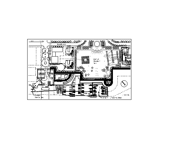
Figure 5: Currently Approved Marina Expansion
Policy Context: The False Creek North Official Development Plan states that any marina should have regard to, among other things, the following:
· uses ancillary to marinas, such as repair facilities and parking, should be accommodated at unobtrusive locations,
· some spaces within marinas should be reserved for visitors,
· marinas should be of a size, number and location to maintain street-end views and long views across the water; not overcrowd the water, especially the central basin,
· services such as parking and loading should be located to be functional and convenient for marina users, and
· opportunities for public boat launch should be achieved.Blueways False Creek Policies and Guidelines state that opportunities should be sought to:
· increase permanent moorage capacity in False Creek, ensuring that any initiatives are consistent with the False Creek North Official Development Plan and other relevant policies, and
· reserve some space within marinas for visitors.There are three other built, or planned, marina facilities on the north shore of False Creek. These are: the built Quayside marina, Plaza of Nations marina, and the Abbott Street marina proposed in the False Creek North Official Development Plan.
Proposal: An initial rezoning application was submitted July 31, 2002 and revised September 5, 2002. The first rezoning application, which was reviewed by the public at an Open House in August, proposed the following (see Figure 6):
· The relocation of 20 berths (4,706 water area square metres) from the currently approved location for expansion, shown in the CD-1 Beach Neighbourhood Guidelines, to create a new marina area east of George Wainborn Park on Waterlot #249,
· Moorage berths that accommodate large boats up to 30 m (100 ft. long),
· The transfer of permitted commercial floor space for land development from site B Area 1B, Beach Neighbourhood, to allow for five single-storey buildings proposed in five locations (391 m² of density), at a maximum size of 5.5 m wide (13 ft.) by 18 m long (60 ft.). The use proposed for these buildings was accessory to the marina uses (i.e., storage, mechanical, laundry, washrooms, clubhouse, etc.), and
· five dedicated berths for transient moorage between the FCYC docks and the Harbour Headline (approximately 600 m² or 6,458 sq. ft. of water area).The first marina proposal was revised to respond to staff and public concerns regarding loss of open water views to the south-east shore of False Creek the large size of boats contemplated, and the proposed number and size of the floating accessory buildings.
Figure 6: First Applicant Proposal
The revised rezoning proposal involves the following, with respect to its provisions for the waterlot and marina in the Beach Neighbourhood (Area 1B) (see: Figure 7):
· Relocation of up to 20 berths (4,706 water area square metres), of the approved marina expansion area in Area 1A ( shown in Beach Neighbourhood CD-1 Guidelines) plus an additional 316 m² (3,402 sq. ft.) of marina use area or 7 berths to create a new marina east of the George Wainborn Park in Beach Neighbourhood Area 1B (total 27 berths, depending on the size of boats),
· one single-storey accessary marina building (150 m² or 1,615 sq. ft. of density), at a maximum size of 9.5 m wide (31 ft.) by 16 m long (53 ft.). The use proposed for this building is accessory to the marina uses (i.e., storage, mechanical, laundry, washrooms, clubhouse, etc.) and is for non-residential purposes, and
· five dedicated berths for transient moorage between the FCYC docks and the Harbour Headline (approximately 600 m² or 6,458 sq. ft. of water area).DISCUSSION
Staff have reviewed the revised proposal with respect to the False Creek North Official Development Plan marina use criteria, and the Blueways Policies and Guidelines for False Creek. The following comments summarize this review along with discussion of related issues.
Ancillary Uses: The accessory marina building proposed by the applicant is 150 m² or 1,615 sq. ft. Because it is for a small marina , staff recommend that the building be no larger than 75 m² (807 sq. ft.). As a point of comparison, the accessory marina building for the Quayside marina is about 200 m² (2,153 sq. ft.) for a marina with 115 berths. A smaller building would also help minimize open water view impacts from the seawall to the south.
Figure 7: Revised Applicant Proposal (Preferred by Applicant)
Parking will be located in an unobtrusive location - in the parking structure for Building 1K in Area 1B (see: Figure 8).
Figure 8: Location of Building K
Visitor Moorage:
The application proposes more visitor moorage nights and visitor services than those contemplated for the previous marina expansion, in front of George Wainborn Park in Area 1A, Beach Neighbourhood.
A total of five permanent berths for visitor moorage, each available 365 days per year, would be made available to the boating public for temporary, short-term moorage through extensions to the False Creek Yacht Club docks. These permanent berths would provide between 700 and 1,600 more moorage nights depending on the number of visitors during the winter, considerably more than the previous marina expansion requirement of 200 visitor nights.
The proposed boater information/moorage referral centre would provide general boating information to the boating public and a moorage referral service to assist visiting boaters in finding local short-term moorage. The centre would be operated daily and staffed generally the same hours of operation as the FCYC office. (i.e., seven days a week in the summer months [May, June, July, August], from 9:00 a.m. to 5:00 p.m and in the winter months, the centre will be staffed at five days a week, from 9:00 a.m. to 5:00 p.m.). The centre will be accessible to the boating public from the water.
The moorage referral service should include keeping track of available marina berths in the downtown Vancouver area daily, and providing available information and/or referrals to the visiting boaters.
Views
The applicant provided an view analysis of the impacts of the new marina location and configuration from five key points along the seawall and Beach Neighbourhood area (see: Figure 9).
Figure 9: View Locations
STREET END VIEWS: The proposal creates open water views from the Richards Street end. The Homer Street extension street end will maintain an open water view, when viewed from Beach Avenue (see Figure 10: View#1). As shown in the view analysis below, the eastern single-accessory building does not obstruct the Homer street end view.
Figure 10: View #1 from Homer Street End
PUBLIC AND PRIVATE VIEWS: View impacts can be summarized as follows:
· Views from George Wainborn Park: Open water views directly in front of the park to the south will be created by the relocation of moorage to Area 1B. These views include Granville Island in the backdrop, specifically the floating homes, Emily Carr School of Design, the Ocean Cement site and Granville Bridge. Long views to the south-east from the park should not be significantly impacted where the park is at a higher elevation than the seawall.
· Views from the Seawall Promontory (View #4): Views to the south east will be impacted in the foreground, particularly during high tides. At the request of City staff, the applicant has agreed to located larger boats away from the promontory at the east end of the marina. (See: Figure 11 and 12 View #4)
Figure 11: View from Seawall Promontory with Marina at High Tide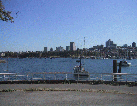
Figure 12: View from Seawall Promontory (Currently)
· Views from the Seawall: The length of seawall with fronting marina uses will be impacted in the foreground. Moreover, the length of seawall with fronting marina uses would increase approximately three fold compared to the length of seawall with fronting marina uses by the previous rezoning. At the request of City staff, the applicant has agreed to align the moorage berths perpendicular to the seawall to allow maximum view penetration through to open water. (See View #2, Appendix G)
·
Private Views: Relocation of the marina area to east of George Wainborn Park moves marina uses into the viewshed of some of the residents who have or will purchase units in buildings on sites 1GHJ and 1K, Beach Neighbourhood. The applicant states they have notified all prospective buyers of sites 1GHJ and 1K of this marina proposal. (See View #3, Appendix G) The applicant notes that relocation of the marina area will improve water views for those who have or will purchase unites in buildings 1D,M,N, and 1O.The relocated marina provides more variety of views for those on the seawall by providing for open water at the Park's frontage, rather than having the marina extending over a longer continuous portion of the walkway. This contributes to a pattern of views of marinas and boat activity alternating with open water views from Burrard Bridge to David Lam Park, with marina uses appearing again at the base of Davie Street (Quayside Marina).
However, prime views are generally considered open water long views, and from the seawall promontory these are south-easterly across to the south shore of False Creek, to Charleson Park, the south shore marinas and residences, and the Broadway skyline (see: Figure 12).
Because the proposed configuration of the new marina in Area 1B impacts these views, staff recommend a modified marina footprint (discussed below).
Water Coverage: The applicant's proposed marina relocation and expansion east of George Wainborn Park represents a net increase of 316 m² (3,402 sq. ft.) in the amount of water covered by marina use. The five permanent berths proposed for visitor/transient moorage, to be provided in the FCYC marina, would add a further, approximate, 600 m² (6,458 sq. ft.).
Some members of the public have raised concerns about this increase in water coverage. About one- third of the new marina footprint is open water, allowing views in between the floating `spines'. In addition, because the new marina location is in a small sheltered bay area east of the park promontory, there are advantages to the new location in terms of not overcrowding the water. The previous marina expansion area was to be to the harbour headline in the narrowest portion of the False Creek channel. Although additional moorageslips are to be provided in this vicinity to accommodate transient moorage, the berths will be within the harbour headline.
Parking and Loading: As required by the Parking By-law, parking will be provided at one space per two berths in Building 1K. Two Class A loading spaces will also be required or a lesser number of the satisfaction of the Director of Current Planning and General Manager of Engineering Services.
Public Access and Boat Launching: Staff believe it is reasonable that the applicant should provide alterations to be developed public ferry dock at David Lam Park, making it wheelchair accessible, e.g., a `ramp rider'. The dock will be accessible to both ferry companies as well as the public for short-term dinghy use and small boat launching.
The public will also be given access to this public ferry dock for non-motorized boat launch and retrieval at nominal or no cost to users. The types of water craft that will be launched from this location are canoes, kayaks, sailboard/wind surfing boards which can be carried by one or two individuals and that do not require boat trailer for launching.
Permanent Moorage: The new marina would provide an increase of about 7 permanent moorage berths, in addition to the 20 berths proposed to be relocated from Area 1A.
Occupation of City Road: The proposed marina will occupy portions of existing dedicated City road along portions of the sloped bank of shoreline, east of the promontory. An agreement will be required to allow occupation of the City road by the marina. Staff are willing to support a term of 40 years, with an option to renew for an additional 40 years, for the use of this area for the marina, as was done at the Quayside marina. This agreement would also secure City rights for the access, maintenance, repair and reconstruction of the shoreline protection works.
Pedestrian Walkway: A significant public benefit that has been agreed to with this marina expansion is the design and construction of a pedestrian walkway across the FCYC site (through Lots 161 and 167) in a location and of a width, as well as on terms and conditions to the satisfaction of the Director of Current Planning and City Engineer.
FCYC has committed to provide this pedestrian walkway in principle. Concerns have been raised by the FCYC and Engineering Services regarding the impacts of this walkway through parking area on the site. When the public ROW is developed through the site, it is anticipated that 10 to 12 surface parking spaces will be lost. Parking requirements for the site will require further review during the Development Permit process, and in conjunction with the development of the final design and layout of the walkway through the FCYC site.Staff are willing to work cooperatively with the FCYC to assess their parking requirements and identify options for locating appropriate parking in the vicinity.
Staff Recommendation - Modified Marina Footprint: (See Figure #13) Staff and PPDC have worked together to identify ways to minimize the view impacts of the new marina footprint. PPDC subsequently submitted a revised mix of boat sizes and marina configuration that goes a considerable way to minimize view impacts.
However, the second floating `spine' of the proposed marina puts boats 10-18 m (35-60 ft.) in length within the sight lines of prime long distance views from the waterfront walkway promontory across to the south shore of False Creek. Because of these view impacts, staff do not support the second `spine' of the proposed marina and recommend it be removed.
Secondly, a smaller ancillary floating marina building would help reduce open water view impacts from the seawall. Staff recommend that the ancillary floating service building not exceed 75 m² (807 sq. ft.), and provide transparency where building function permits it.
Figure 13: Staff Proposal
Staff support the mix and location of boat sizes proposed by the applicant for the longer float near the seawall, specifically eight 15 m (50 ft.) boats on the west portion of the float, then a 18 m (60 ft.) boat east of that, two 30 m (100 ft.) boats, one of 27 m (90 ft.) and one of 24 m (80 ft.). Ultimately, these boat sizes might vary, but staff recommend that the longer boats be located at the eastern end of the spine.
Staff's recommendation would reduce the size of the marina footprint east of George Wainborn Park by approximately 14 berths. The applicant has expressed serious concerns about the financial viability of this smaller marina footprint. Staff suggest that Council consider permitting the applicant to develop the balance of berths from the reduced marina footprint in the previously approved marina expansion area (Area 1A). This would allow PPDC the option of developing about 14 additional berths, as well as the 5 dedicated transient moorage berths, in the area between the Harbour Headline and FCYC docks and to the east of the FCYC docks at the foot of George Wainborn Park.
Maintaining some of the proposed berths at the foot of George Wainborn Park would trade off some of the view benefits of the applicant's revised proposal. Specifically, this option would encroach upon short views across to Granville Island that would have been created at the foot of the park by the applicant's revised proposal. However, these views across to Granville Island are shorter, and generally considered less important than the long open water views that would be compromised by the second spine east of George Wainborn promontory. If this proposal is supported, the applicant will have to make arrangements to lease portions of the Richard Street right-of-way.
Public Benefits: The public amenities referred to in Appendix B will be secured through legal arrangements between the applicant, FCYC, and the City. Public benefits will be attached by covenant to Waterlot #267 or #249 so that the owner, PPDC, or other leasee, will assume responsibility for provision of the public benefits, should the FCYC not continue to lease Waterlot #267.
Board of Parks and Recreation Comments: The proposed marina causes a loss in quality of public view. Council has to weigh these impacts against the proposed public benefits. Park Board staff are supportive of the rezoning as long as the new marina configuration adheres to the draft rezoning conditions, including most importantly conditions that keep views from the promontory to the southeast free of obstructions. (See: detailed comments, Appendix E.)
Urban Design Panel Review: The Urban Design Panel will review this application on September 18, 2002 and their comments will be forwarded to Public Hearing.
PUBLIC INPUT
Varied public opinion regarding the applicant's marina expansion/reconfiguration has been received. An open house was held on August 19, 2002 and was attended by members of the False Creek Yacht Club, paddlers, kayakers, area residents as well as purchasers of units in the buildings that have been listed in the Beach Neighbourhood area. The majority of those in attendance and who filled out comments sheets (62%) supported the proposal to relocate the berths from in front of George Wainborn Park (Area 1A) to the new location.
Generally, members of the False Creek Yacht Club were supportive of the proposal. Paddlers, including kayakers, have raised concerns about the views and increasing boat congestion of the Creek. Others have raised concerns about environmental considerations (garbage disposal, noise impacts, local environmental impacts etc.) associated with marinas and boats generally.
The Planning Department has received 21 e-mails in opposition to the marina proposal as of September 11, 2002.
APPLICANT COMMENTS
We believe that our revised application is a fair and balanced solution responding to a number of diverse and sometimes conflicting objectives. It provides a number of key public benefits as noted in this report. It offers more varieties of views by providing for open water at the Park's frontage, rather than having the marina extending over a longer continuous portion of the walkway. Combined with the impact of tides fluctuations this will create an interesting pattern of views of marinas and boat activity alternating with open water views. Our application also provides for longer-term tenure for the False Creek Yacht Club as well as much-needed moorage in False Creek including moorage for visiting boaters. From our experience with the recently opened Quayside marina the 150 m² ancillary building is a minimum size required regardless of the size of the marina; unfortunately the 75 m² building recommended by staff is too small.
We have carefully reviewed the solution proposed by staff. It creates a much smaller eastern marina that will have a number of operational concerns. The economies of developing such a small marina are also a concern. While it is clearly not our preferred solution, we would reluctantly find it acceptable if the size of the ancillary building was set at the 150 m² as wehave proposed. Again we believe that our revised application is a fair and balanced solution offering a number of key public benefits to the residents of Vancouver and specifically False Creek North.CONCLUSION
This text amendment of the Beach Neighbourhood Area 1B zoning represent an effort by the City, Pacific Place Developments, and the False Creek Yacht Club to achieve a variety of public and private benefits. The proposal resolves long-standing issues, including the provision of a public right-of-way across the provincial lot which would bring a walkway closer to the water as well as other public amenities. However, long south-easterly views across the water from locations on the seawall walk will be compromised by putting boats within their sightlines with the new marina location. Staff's recommended configuration would minimize those view impacts. The principal decision for Council is whether the relocation of planned berths in a new location east of the George Wainborn Park is appropriate in light of the identified public benefits.
The Director of Current Planning recommends that the application be referred to Public Hearing and approved subject to conditions. He also recommends that he make application to amend the False Creek North Official Development Plan to include the proposed marina on the illustrative site plan, and that this application be referred to the same Public Hearing and approved.
* * * * *

APPENDIX A
Page of 2
DRAFT CD-1 BY-LAW TEXT AMENDMENTS
500 Pacific Street (By-law No. 7675)
An amending by-law will be prepared generally in accordance with the provisions listed below.
1. In Section 3 (Uses), insert "including Marina limited to 13 moorage berths" in (f) after "Cultural and Recreational Uses,".
2. In Section 4 (Sub-Areas), replace Diagram 1 with the new diagram below which adds a fifth sub-area (5) and a seventh site (G):
DIAGRAM 1
APPENDIX A
Page of 2
3. In Section 5 (Floor Area and Density), replace Table 2 by the following:
Table 2 - Maximum Floor Area (in square metres)
Sub-Area and Site
|
Uses | |||
Sub-Area |
Site |
Residential |
Retail, Service and Office |
Cultural and Recreational |
Sub-Area 1 |
Site A |
38 567 |
N/A |
N/A |
Sub-Area 1 |
Site B |
48 042 |
1 110 |
N/A |
Sub-Area 2 |
Site C |
30 696 |
0 |
N/A |
Sub-Area 2 |
Site D |
13 109 |
N/A |
N/A |
Sub-Area 3 |
Site E |
N/A |
N/A |
N/A |
Sub-Area 4 |
Site F |
N/A |
N/A |
N/A |
Sub-Area 5 |
Site G |
N/A |
N/A |
75 |
4. In Section 6 (Height), replace Table 4 by the following:
Table 4 - Maximum Height (in metres)
Sub-Area and Site
|
Maximum Height (in metres) | |
Sub-Area |
Site | |
Sub-Area 1 |
Site A |
91 |
Sub-Area 1 |
Site B |
110 |
Sub-Area 2 |
Site C |
71 |
Sub-Area 2 |
Site D |
53 |
Sub-Area 3 |
Site E |
N/A |
Sub-Area 4 |
Site F |
N/A |
Sub-Area 5 |
Site G |
5 |
* * * * *
PROPOSED CONDITIONS OF APPROVAL
500 Pacific Street (By-law No. 7675)
These draft conditions of rezoning approval are subject to change and refinement by staff prior to the finalization of the agenda for the public hearing.
FORM OF DEVELOPMENT
(a) THAT the proposed form of development be approved by Council in principle, generally as prepared by Peter Busby and Associates Architects Inc., and stamped "Received, City Planning Department, July 31, 2002" and further amended as of September 05, 2002, provided that the Director of Planning, or Development Permit Board, may allow alterations to the form of development when approving the detailed scheme of development as outlined in (b) below, except that the marina moorage area (or footprint) must be reduced from 5 022 m² to approximately 2 728 m², the maximum size of the ancillary floating marina building must be reduced from 150 m² to 75 m², and the number of floats reduced from two to one.
DEVELOPMENT APPROVAL CONDITIONS
(b) THAT, prior to final approval by Council of the form of development, the applicant shall obtain approval of a development application by the Development Permit Board who shall have particular regard to the following:
DESIGN DEVELOPMENT
1) design development to the marina configuration and lay-out to maximize public views from the adjoining seawall public walkway and nearby George Wainborn Park aspects to review include, and are not limited to:
- limiting the number of float spines to one and maintaining its east-west orientation,
- locating the larger moorage berths at the eastern end of the spine,
- limiting the number of ancillary floating service buildings to one, limiting its width, length and height, and providing transparency where building function permits it, and
- not locating any berths or floating building in the Homer Street-end view corridor.
DESIGN GUIDELINES
(c) THAT proposed revisions to the Beach Neighbourhood (500 and 600 Pacific Street) CD-1 Guidelines be adopted by resolution of Council at time of enactment of the CD-1 and False Creek North Official Development Plan amending by-laws. (see Appendix D).
LEGAL AGREEMENTS
(d) THAT, prior to enactment of the CD-1 and False Creek North Official Development Plan amending by-laws, at no cost to the City, the registered owner shall make arrangements for:
NO-DEVELOPMENT COVENANT
1) Execute a Section 219 Covenant, satisfactory to the Director of Legal Services, providing that there will be no development of Waterlot #249 and #267 nor will there be any Development Permit issued in respect of any building or improvements to be constructed on Waterlots #249 and #267 pursuant to this rezoning until all of the conditions and agreements required below are completed to the satisfaction of the General Manager of Engineering Services, and the Director of Legal Services.
SOILS - STUDIES AND REMEDIATION PLAN
2) Obtain and submit to the City copies of all soils studies and the consequential Remediation Plan, approved by (Pacific Place) the B.C. Ministry of Environment. Enter into or cause to be entered into by the Province of British Columbia, agreements satisfactory to the Director of Legal Services, providing for the remediation of any contaminated soils on the area in accordance with a Remediation Plan approved by the Ministry of Environment and acceptable to the City, providing security satisfactory to the Director of Legal Services for the completion of remediation and indemnifying the City, the Approving Officer and the Park Board against any liability or costs which may be incurred as a result of the presence of contaminated soils on the site. Provided however, Concord Pacific Group Inc. or the Province shall not be responsible for soil remediation costs for lands owned by the City at the date of this report.
SOILS - REMEDIATION PLAN
3) Submit to the City a remediation plan for all newly dedicated streets and utility rights-of-way required to serve the subject site, including utility construction plans compatible with the accepted remediation plan, together with any agreements deemed necessary by the City Engineer providing for the construction and installation of remedial works, including monitoring systems for, among other things, water discharges and ground water flows; and any other remedial works or systems required by the City Engineer all to the satisfaction of the City Engineer and the Director of Legal Services.
SOILS - INDEMNITY
4) Execute an Indemnity Agreement, satisfactory to the Director of Legal Services, providing for security to the satisfaction of the Director of Legal Services, protecting the City, the Approving Officer and the Park Board from all liability or damages arising out of or related to the presence of contaminated soils on the lands comprising the subject site, howsoever occurring, arising during the period commencing immediately following the Public Hearing until such time as the Ministry of Environment issues an approval, in a form satisfactory to the Director of Legal Services and the City Engineer, certifying that the subject site, including all roads, utility corridors, open spaces and parks contained therein, have been remediated to Provincial Standards as defined in such approval. Provided however, this indemnity agreement shall not apply to lands within Area 1A owned by the City at the date of this report.
SOILS - VANCOUVER CHARTER
5) Shall, as required by the City Engineer and the City's Director of Legal Services in their discretion, do all things and/or enter into such agreements deemed necessary to fulfill the requirements of Section 571(B) of the Vancouver Charter.
SOILS - OCCUPANCY
6) Execute a Section 219 Covenant, satisfactory to the Director of Legal Services, that there will be no occupancy of any buildings or improvements on the subject site constructed pursuant to this rezoning until an approval, in a formsatisfactory to the Director of Legal Services and the City Engineer have been provided to the City by the Ministry of Environment.
MARINA
7) Execute an agreement with a term and cancellation provisions, satisfactory to the City Engineer and the Director of Legal Services, to allow for the occupation by the Marina of portions of City roads along the shoreline protection works, at a nominal fee for such use, over a term of 40 years with an option to renew for an additional 40 years. This agreement is to allow for:
i) access for inspection, maintenance, and replacement of the City works, and may involve the relocation of the Marina at such time at the Owner's cost; and
ii) allow access ramps and servicing for the Marina to connect to the City's seawall.
BRIDGE PROXIMITY
8) Execute a Bridge Proximity Agreement for land Lot #266 and Waterlot #267 to the satisfaction of the General Manager of Engineering Services.
SERVICES AGREEMENT
9) Execute a service agreement, satisfactory to the City Engineer and the Director of Legal Services, to ensure that all on-site and off-site works and services necessary or incidental to the servicing of the subject site (collectively called the "Services") are designed, constructed, and installed at no cost to the City, and to provide for the grant of all necessary street dedications and rights-of-way for the Services, all to the satisfaction of the City Engineer and the Director of Legal Services. Without limiting the discretion of the said City officials, this agreement shall include provisions that:
i) no Development Permit in respect of any improvements to be constructed on the subject site pursuant to this rezoning shall be issued until the design of all of the Services is completed to the satisfaction of the City Engineer;
ii) the design of all the Services will be completed to the satisfaction of the City Engineer prior to: (a) tendering for the construction of any of theServices; or (b) any construction of the services if the Property Owner decides not to tender the construction;
iii) no occupancy of any buildings or improvements constructed pursuant to the rezoning shall be permitted until all Services are completed to the satisfaction of the City Engineer;
iv) alteration to be provided to the proposed ferry dock facility at David Lam Park, to provide wheelchair accessibility, the satisfaction of the City Engineer;
v) provision of 5 permanent visitor berths, on terms satisfactory to the City Engineer (terms will included availability, duration, conditions of use, annual reporting and fees to be charged);
vi) provision of public amenities including a visiting boater information/referral centre, pump-out station, laundromat, and toilet facilities for visiting, transient boaters, all to the satisfaction of the City Engineer; and
vii) design and construction of a pedestrian walkway through Lots 161 and 167, in a location and of a width, as well as on terms and conditions to the satisfaction of the City Engineer and the Director of Current Planning.
SHORELINE WORKS
10) Execute agreements, satisfactory to the City Engineer and the Director of Legal Services, obligating the property owners, at no cost to the City to design and construct the shoreline works relevant to the subject site and which shall include a waterfront pedestrian/bicycle system (collectively called "Shoreline Works"), to the satisfaction of the City Engineer (and the General Manager of Parks and Recreation where such improvements encroach on park areas). This agreement will include provisions that:
i) no Development Permit in respect of any improvements to be constructed on the subject site pursuant to this rezoning shall be issued until the design of the Shoreline Works is completed to the satisfaction of the City Engineer;
ii) the design of the Shoreline Works will be completed to the satisfaction of the City Engineer prior to tendering for the construction of these works, or the commencement of construction of the Shoreline Works if the property owner decides not to tender the construction;
iii) the property owner shall grant all requisite ownership rights to the City, whether by dedication or perpetual right-of-way (as the City shall determine), over lands containing the Shoreline Works and shall grant access thereto, to the satisfaction of the City Engineer and the Director of Legal Services;
iv) the property owner shall assure access to, and support of, the Shoreline Works from both the uplands and the water lots, and shall grant rights-of-way therefore as required by the City Engineer, including a blanket right-of-way over the water lots for access to the Shoreline Works for maintenance and repair purposes;
v) the property owner shall amend the temporary walkway letter agreement dated October 16, 1987, to the satisfaction of the City Engineer and Director of Legal Services, to include provisions for improved maintenance of any re-routings of the temporary walkway and for bypassing of construction areas;
vi) the water lots shall be maintained, to the satisfaction of the City Engineer, in such a manner as to preserve the amenity value inherent in the Shoreline Works;
vii) the property owner shall obtain all necessary approvals and permits under the Navigable Waters Protection Act (Canada) and any ocean dumping permits which may be required by Federal authorities; and
viii) the construction of the Shoreline Works shall be completed in accordance with the following: no occupancy of any buildings or improvements constructed pursuant to this rezoning shall be permitted until the Shoreline Works is completed to the satisfaction of the City Engineer (and the General Manager of Parks and Recreation where relevant).
FLOODPLAIN
11) If necessary execute a flood plain covenant, satisfactory to the Director of Legal Services and the B.C. Ministry of Environment.
AMEND COVENANTS
12) Re-evaluate, amend and/or release all existing covenants and rights-of-way to address the proposed development to the satisfaction of the Director of Legal Services.
PARKING AND LOADING
13) Execute an offsite parking and loading covenant securing all required parking and 2 Class A loading spaces for Waterlot #249.
14) Obtain a right-of-way for a pedestrian walkway over Lots 161 and 167 at locations and on conditions satisfactory to the General Manager of Engineering Services and the Director of Legal Services.
Where the Director of Legal Services deems appropriate, the preceding agreements are to be drawn, not only as personal covenants of the property owner, but also as Covenants pursuant to Section 219 of the Land Title Act.
The facilities to be provided including the Services, and site remediation, may, in the discretion of the General Manager of Engineering Services and Director of Legal Services, be constructed in phases, in accordance with phasing plans satisfactory to the aforesaid officials, and the respective Agreements will provide for security and occupancy restrictions appropriate to such phasing.
The preceding agreements are to be registered in the appropriate Land Title Office, with priority over such other liens, charges and encumbrances effecting the subject site as is considered advisable by the Director of Legal Services, and otherwise to the satisfaction of the Director of Legal Services prior to enactment of the by-law; provided however the Director of Legal Services may, in her sole discretion and on terms she considers advisable, accept tendering of the preceding agreements for registration in the appropriate Land Title Office, to the satisfaction of the Director of Legal Services, prior to enactment of the by-law.
The preceding agreements shall provide security to the City including indemnities, warranties, equitable charges, letters of credit and withholding of permits, as deemed necessary by and in a form satisfactory to the Director of Legal Services.
* * * * *
DRAFT AMENDMENTS
FALSE CREEK NORTH OFFICIAL DEVELOPMENT PLAN
(Adopted by By-law No. 6650, April 10, 1990)
An amending By-law will be prepared generally in accordance with the revised provisions listed below. The by-law amendments recommended by the Director of Current Planning will show a new marina moorage area (or footprint) reduced from 5 022 m² to approximately 2 728 m² and the maximum size of the ancillary floating marina building reduced from 150 m² to 75 m².
1. Figure 8 (Marinas) will be replaced by an amended figure which shows a reduced marina moorage area (footprint) in Area 1A and new marina area in Area 1B to the east of the 1A seawall promontory in George Wainborn Park.
2. Figures 12A (Illustrative Plan), 12B (Non-Market Housing Sites) and 12C (Maximum Tower Heights) will be replaced by amended figures which show a reduced marina moorage area (footprint) in Area 1A and new marina area in Area 1B to the east of the 1A seawall promontory in George Wainborn Park.
* * * * *
DRAFT AMENDMENTS
BEACH NEIGHBOURHOOD CD-1 GUIDELINES
(Adopted by City Council October 21, 1999)
Guideline amendments will be prepared generally in accordance with the following.
1. In Section 4 (Precinct Guidelines), replace Figure 3 (Development Precincts) with a new figure which adds an eighth precinct (8) for the proposed new marina in Area 1B between the George Wainborn Park promontory and the foot of Homer Street.
2. In Section 4 (Precinct Guidelines), replace the diagram labelled Precinct 7 with a new diagram which reduces the easterly part of the area labelled "permitted expansion zone" and adds a notation to indicate a maximum of 14 berths in the expansion area, and adds a notation to indicate 5 permanent visitor moorage berths in the remaining expansion zone between the existing marina and the harbour head line.
3. In Section 4 (Precinct Guidelines), insert after the diagram labelled Precinct 7 a new diagram labelled Precinct 8 showing the new marina between the George Wainborn Park promontory and the foot of Homer Street.
4. In Appendix A, replace the Illustrative Site Plan with a revised diagram which reduces the area labelled "permitted expansion zone" in Precinct 7 and which shows the new marina in Area 1B between the George Wainborn Park promontory and the foot of Homer Street in Precinct 8.
* * * * *
COMMENTS FROM THE PUBLIC
REVIEWING AGENCIES AND THE APPLICANT
PUBLIC INVOLVEMENT
Notification: Two information signs were installed on the site and 2,507 notification letters were mailed on July 31, 2002 to residents within a 2 block radius of the site. Also 1145 notification letters were sent to purchasers of dwelling units in Beach Neighbourhood.
Public Meetings: A public open house was held on August 19, 2002 to provide information about the applicant's first proposal (see Figure 4). A summary of responses to comments sheets is below:
GENERAL
Do you support the proposed marina re-configuration to create a new marina in Area 1B?
Yes: 31 62%
No: 23 38%
Total Responses: 54 100%
Why/why not?
IN FAVOUR:
Provides Needed Moorage and amenities.
1) More properly managed and controlled berths are needed in Vancouver as opposed to the present policy permitting squatters to abuse the harbour. World class seaport cities cater to private marine vessels - Vancouver should do so as well, so Vancouver needs more not less marine (moorage) facilities. Moorage facilities one well served by marine oriented business buildings.
· This is an active club that provides multi services to people who frequent the creek areas. The members have shown great patience and leadership in the promotion and support of our city.
· False Creek Yacht Club should be able to keep all the moorage space they currently have as they provide excellent community service and transient moorage in the summer which is SADLY lacking in Vancouver.
· Makes good use of existing water space. Transient, unkept boats would no longer be at anchor there. Cruise tours and visitors would have a more even view of boats/marinas as they go up False Creek. Boats would not obstruct the view of people in the park or on the seawall.
· Vancouver needs visiting boats - great for the economy.
· Good for Tourism.
· City needs a visitor centre! Great revenue for the city.
· For the public benefits (public access for Kayaks & canoes). For the certainty of knowing what will be there.
· The proposal has the potential to provide improved public access to marine recreation. However, the current proposal does not yet satisfy this potential.
· Vancouver thrives mostly on tourism. Ambiance and natural beauty of this city center are most important. Boating and accessibility add to this aspect.
· Yes. It may finally let Vancouver clean up the transient issue in the creek.
· This reconfiguration will enhance False Creek as a world class city.
· Sounds like a reasonable change to something which has already been approved. Anything which increases water-based use in a Province like B.C. and a city like Vancouver can only be healthy.
Enjoy Views
· Better view.
· Boats are beautiful.
· This is effective use of this area. No negative impact, with valid benefits as listed above.
Other.
· Supports cities plans.
· What difference does it make whether a marina is a few hundred feet one way or the other.
· People in the area are an asset to the general environment. The vibrance of the marina is reflected and everything that goes ___ _______ (in neighbourhood).
· Useful way to produce tax revenues.
· It's a good thing! #700-1675 Hornby St.
· The perfect use for the area with no noticeable negative impact enhances the look of the Creek.
· Like this.
· The relocation allows better use of the False Creek water i.e., less encroachment.
NOT IN FAVOUR:
Congestion/Water Coverage/Views.
· False Creek is quite congested already; further development will not be conducive to the Ecology; of False Creek.
· The capacity for boats is growing much to rapidly. Large boats are restricting the views and the use of canoes and Kayaks. More pollution, more traffic and more noise - enough!!
· There are enough boats moored in False Creek now. False Creek should be left for canoes, kayaks and the little water taxis's as well as rowing clubs. 200 visitors might/will add to the pollution.
· It reduces the narrowing of the channel between downtown and Granville Island. However, large 50 feet - 100 feet boats manoeuvring in/out of their slips will increase the congestion.
· As a person who paddles False Creek almost every day of the week - I have concerns about increased motor boat use of False Creek as well as losing more area of the creek. The False Creek Racing Canoe Club has 1200+ members and about ½ are out on False Creek on a given day. Increased Marinas is making it more and more dangerous for persons in self propelled boats. Vancouver prides itself in being a fitness/sport orientated city with accessibility for all. Enough already with developing the water on False Creek.
· Increased boat traffic in a narrow area affecting the boat traffic passing through progressing east. Traffic causing additional safety concerns for self propelled boats exiting Alder Bay and entering from the Burrard docks. Specifically False Creek Canoe Club put 400 people on average per night on this piece of water. Currently we are encountering a lack of width in the water space. This addition will further reduce safe user space. Additional wave action that will affect Spruce M.
· Preserve the gorgeous view of the water for visitors and residents. There are enough Marinas in False Creek currently. We are at a maximum capacity for them.
· Too large boats. Increased usage of Creek, not enough consideration of other users amenities, potential eyesore.
· There's already an agreement: 1998. This isn't a bigger FCYC Marina, it's a new marina. Limited moorage, because the vessels will be big - how many smaller vessels - or are they priced right ouf the market? Great views will be blocked to the East.
· Bigger boats will obstruct the view there are already enough boats in the creek.
· The proposed rezoning to relocate marina slips will further restrict the waterways along the False Creek that are available for public use and enjoyment. The rezoning plan "clutters" the waterway and the view of the water. The congestion of marines undermines the natural beauty of the area.
· Too much! Leave it as is.
· Safety of the others must be considered please! I think ½ of the proposal should be allowed only!
Residential Impacts/Environmental Concerns
· Not more boats & their garbage. They attract rats.
· Traffic flow on North Side is bad noise do not need increase!
· The proposal will only have negative impacts on the False Creek area and for Vancouver. It reduces and minimizes the body of water available for physical and visual enjoyment for residences of all communities' around False Creek. Will create substantial pollution impact in terms of: Noise pollution from all the combustible, especially diesel engines. Water pollution such as oil and gas leakage, garbage, junks, etc., especially for visitors and transients from outside of Vancouver or Canada who do not care as much of our City than we do. Air pollution from all the added combustible engines, pumps, laundromat, toilets, etc. Increase the load and usage of all park, walkway, green space, water body over the existing accepted limits and negative impede on the enjoyment of the residents of the False Creek and Yaletown communities. Create rodent and rat problems similar to the rock banks of Granville Island. Increase traffic...creating traffic and parking problems. Nothing to contribute positively to the residents and people of the surrounding communities and to Vancouver.
· When we purchased our unit at the waterfront we did so under the existing zonings and are not interested in expanding the use of land and water moorage.
· Why should residents of False Creek have visitor moorage or indeed, provide moorage to residents of Kerrisdale?
· Benefits for residents are unclear or minimal.
· Takes Marine linear footage.
· Proposal will have the following negative impact on the community. Increased Traffic - negatively affect already bad parking in the neighbourhood and surrounding areas. Over ____ of park and all other existing recreational facilities. Water pollution for and from increased moorage & other building facilities. Noise pollution from powered and other boat traffic. Air pollution from motor, diesel engines and powered boats. Negatively affect the quiet enjoyment of all residents of the immediate and surrounding community.
· Create & worsen traffic problems/situations. Create & worsen parking in the community and surrounding community. Impede water/view/quiet enjoyment of seawall and park facilities by residents of the communities in the neighbourhood and for all Vancouverites. Water pollution for over/increase usage and floating structures and facilities in the proposal. Garbage pollution from increase usage. Especially from visitors and transients who are not committed nor concerned about our city and neighbourhoods. Noise pollution form all the combustable engines on boats, pump-out station., etc especially in the early mornings. Air pollution from all the combustable engines. Eye sore from the south shore.
· More traffic-create traffic problems. Parking problems, reduce quiet enjoyment of seawall and public park Negatively impact view for all communities around False Creek. Water pollution & air pollution.
FORM OF DEVELOPMENT
2. Do you have any concerns about impacts rising from this proposal?
Yes: 24 75%
No: 8 25%
Total Responses: 32 100%
YES:
· Water views
· water views, distant views across the water, public access to the water, - density of False Creek North is both people, boats and rats!
· Water views, Public access to the water
· Water views, Distant views across the water, public access to the water. Water views are now diminished. The marina at the foot of Davie (Marinaside) leaves only a sliver of water view between it and the Marina at Monk McQueens.
· Water views, Distant Views across the water, Public access to the water.
· Water views, Distant Views across the water, Public access to the water.
· Water Views, Distant Views across the water, Public Access to the Water. I feel the impact of further development will be very regretful in the future. Pollution-congestion.
· Water views, Distant Views across the water. The water views will be lost. Looking at bunch of moored boats is not a view of the water.
· Water views, Public access to the water.
· Public access to the water. Ensure that there is convenient access for all Beach Crescent residents to bring a Kayak or canoe down to the Creek, and ensure that a limited rental operation is included.
· Water views. Decline in Tourism because of blockage of the view.
· A port city like Vancouver must include boat space and boats as a top priority.
· Public access to the water. The relocated slips are exclusively for very large boats. This is equal to replacing a fine-grain neighbourhood with a suburb full of monster-houses. While the market may/prefers deriving greater profits from larger boats, it is not conducive to a well rounded boating community. Some thought might be given to providing access to water recreation by the public without forcing affiliation with Concorde Pacific of FCYC.
· Water views, Public access to the water, clutter rather water along shorewalk.
· My biggest concerns are decreased water area and increased motor boat traffic.
· Water views, Distant views across the water, Public access to the water. Currently waterviews seem accessible only by triangulating between hi-rise buildings. Myconcern is not so much public access but the safety of all boats including dragonboats, Kayaks etc., having reduced room to manoeuver.
· There is plenty of access by the Burrard Civic Marina to launch boats. I do not see where a person would park if they launched a Kayak any where near either site.
· Waterviews
· Distant Views across the water
· My concerns also relate to the decreased natural water flow through False Creek due to additional, perhaps largess marina slips. The water near the new marina a the foot of Davie is stagnate and smelly due to the number of marina slips. There has already been much news coverage of the pollution in False Cree. Adding more marina slips and extending them farther east along False Creek only increases the chance of more stagnation and more pollution. Given the profit motives behind this rezoning, we should assume that the largest slips possible will be built. You will note that the boats in the Davie/Marina-side Crescent area are almost all power boats, not sail boats, which increases fuel-spill likelihood.
· water views, distant views across the water, public access to the water.
· Water views, distant views across the water, public access to the water.
· Water views, distant views across the water, public access to the water. Noise pollution. Could attract rodents and rats to the North Shore's of False Creek as in Granville Island - create health problems. As in all areas where visitors are attracted, crime will increase. Will contribute nothing positive to the communities around False Creek & Yaletown. Residents & users of designed current facilities are asked to sacrifice for someone's profit.
· Water views, Distant views across the water, Public access to the water.
NO:
· As laid out it should work out very well.
· No - people love to be part of the atmosphere and hubbub- that's why we live where we do - in the middle of the city and the middle of the action.
· none.
· No
· No. This appears to be an excellent proposal and will only enhance the creek.
· No concerns.
· Marinas tend to be a positive view for most people. False Creek is an active place. People expect to see activity.
· No specific concerns
OTHER
3. Do you have any other comments or suggestions?
(Responses: 20)
· I disagree with more density into the Beach Neighbourhood area. Boaters add to our density too. I don't think for a moment the developer is doing this for our good. They just want t make more money by cramping more people into an area like ours destroying a fine balance for city livability.
· I find kayaking, canoeing and the Dragon Boat Races (and training) a pleasure to watch and to participate. These large vessels, fossil fuel burning are not environmentally friendly.
· Leave the existing zoning as is!! Please.
· Please leave the existing zoning in place.
· Leave the marina as it is and stop increasing the density of this neighbourhood.
· Put this Marina at Kits Beach or English Bay - then you would hear the screams.
· Keep the buildings near the water at the heights that they have been slated for by zoning. At most, increase perhaps 2 storeys or 10%, whichever is less. For the social housing sites, ensure they are neat and landscaped fully when the market projects are completed in any given block. Consider putting in seniors congregate housing as an alternative to non-market housing if funding for non-market housing cannot be secured from Victoria/Ottawa.
· I believe the purposed development will only enhance the area.
· How about mooring the boats over by Kits, Jericho, UBC, etc., (or North Shore). There is obviously demand for it. However we should not block the view for everyone else. For every boat moored here, there is a few hundred to a few thousand people who use the area without boats. Whose best interest are we representing here?.
· No.
· Provide assurances that the public boat-launch and facilities will be adequately provided, including: engaging a consultant, providing efficient access and ancillary facilities for public access: - long- term parking, showers, hose bibs, staging areas etc., washrooms, change rooms/showers.
· 18 metre long (54 + ft.) storage/utility sheds seem excessively long.
· I'm against extra buildings for the larger ships.
· How about making the walk path wider for bikes, rollerskates and people.
· Concord has proven professional and has already built a first class marina. There is no negative impact to relocating this development.
· To increase the number of the slips in the new marina.
· Do not relocate the marina slips as ______ in the rezoning; rather just require improvements as to what is already there.
· This is a commercial operation for the benefit & greed of a few at the expense of the enjoyment and benefits of the residences of the False Creek, Beach and Yaletown neighbourhoods. Should not be allowed at all.
· No expansion or increase of boating usage and facilities should be allowed.
· Strongly oppose!!
In addition, approximately 20 e-mails opposing the marina have been forwarded to Current Planning as of September 11, 2002.
ENGINEERING SERVICES COMMENTS
In a memo dated August 29, 2002, Engineering Services advises:
Engineering Services has completed a review of the revised rezoning proposal for Beach Neighbourhood (Marina Reconfiguration), and we provide the following comments:
Land Survey Comments
A portion of the proposed marina dock and ramp structures, floats, and moorage are shown to encroach into the unnamed portion of City street. These encroachments should be deleted or the applicant should make arrangements to the satisfaction of the General Manager of Engineering Services and the Director of Legal Services for Encroachment Agreements or any other suitable arrangements.
A charge summary is required.
Sewers and Drainage Design Comments
There are no City sewer mains available for servicing this site. Please contact David Picker (873-7357) and Michael Irvine (873-7375) for details.
Waterworks Design Comments
There are no City watermains available for servicing this site. Please contact Dan Walker at 873-7311 for details.
Blueways Comments
Concord's proposal would displace allowable anchoring space in False Creek. To compensate for this, as well as to provide additional boating amenities, we would like the applicant to provide the following:
· Boater information/moorage referral centre - This would include providing general tourism and boating information to the public, and a moorage referral service to assist visiting boaters in finding local short-term moorage. The centre should be staffed 7 days a week, from about 8 am to 8 pm, and be accessible to the public from the water, with an appropriately sized and signed dock available for visiting boats to temporarily moor to while they visit the centre.
The moorage referral service should include taking inventory of available marina slips in the Downtown Vancouver area daily, and providing availability information and/or reservations to the visiting boaters.
· Provision of Boating Facilities/Amenities for Visiting Boaters - Pump-out facilities, to be available for users of the marina and also the general boating public. Showers, laundry, washrooms, and water to be available for the general boating public.
· Provision of short-term moorage - A total of 200 marina spaces per year should be made available to the public, from the beginning of May to the end of September, for temporary, short-term moorage. Four permanent visitor moorage spaces are also required.
The conditions of annual reporting and advertising for the short-term moorage spaces should be similar to the requirements of the Quayside Marina. Fees charged for temporary moorage should be to the satisfaction of the General Manager of Engineering Services.
· Liveaboard Spaces - There is a high demand for liveaboard moorage in Vancouver and currently there is limited space available. Some liveaboard moorage should be encouraged at the proposed marina, either through the proposed expansion or through the False Creek Yacht Club (FCYC). Council has expressed interest in creating additional liveaboard spaces to help resolve the long-term anchoring issue in False Creek.
· Public Dock - A wheelchair accessible public dock should be required (install a "ramp rider"). The dock should be accessible to both ferry companies on terms and conditions approved by the General Manager of Engineering Services. As well, it should be made available to the public for short-term dinghy use and small boat launching.
Additionally, marina spaces and the marina service building should be designed to minimize blocking of views from the shore.
Greenways Comments
As part of the rezoning, a right-of-way for cyclist and pedestrian access should be secured through the False Creek Yacht Club site adjacent to, or close to, the water.
Transportation Comments
Provide bollards on the southern side of the vehicle turnaround on Homer Mews to prevent vehicular access south of this vehicle turnaround, at locations to the satisfaction of the General Manager of Engineering Services.
Provide to the satisfaction of the General Manager of Engineering Services, a minimum of 2 Class A loading spaces at grade on Lot K, in a location convenient to the Homer Mews and the marina. Provide appropriate rights of access and use to marina users. This loading shall be provided within 60 days of the issuance of the occupancy permit for the marina, and may not be used to satisfy Development Permit loading requirements for the future development on Lot K.
Provide off-site (Lot K) parking as per the Parking By-Law. Parking shall be located to the satisfaction of the General Manager of Engineering Services, in a designated and easily accessible area, convenient to the marina. These parking spaces shall be signed "Marina Parking" and shall be maintained at all times for such purpose. These spaces may be available to non-marina users under terms and conditions acceptable to the marina users. These spaces may not be used to satisfy a Development Permit requirement for visitor parking for the future residential development on Lot K. This parking and rights of access shall be provided and available within 60 days of the issuance of the Occupancy Permit for the marina.
Provide garbage receptacles/facilities for the marina, to the satisfaction of the General
Manager of Engineering Services.
Provide within the rezoning document, details of all requirements for public amenities and uses to be provided within the False Creek Yacht Club or elsewhere off-site, and provide details to show compliance with all required parking and loading for the marina and for the FCYC.
Provide public access for non motorized boat launching and retrieval from the FCYC docks and facilities at nominal or no-cost to the user. The types of water-craft intended to be launched are canoes, kayaks, and sailboard/wind surfing apparatus which can be carried by one or two individuals and which does not require a boat trailer for launching.
Consider providing amenities for visiting boaters and seawall users such as changing facilities, storage lockers, and bicycle racks, within a building operated by the FCYC or at the new marina.
The relaxation and exemption provisions of the Parking By-Law will be available.
Utilities Design Branch
Any changes to the underground/overhead utility network to accommodate new services to this site must be reviewed by the Utilities Design Branch.
Agreements
Note: Legal Agreements were recommended as conditions of rezoning approval, subject to prior review by Legal Services. (See Appendix B)
PARK BOARD COMMENTS
The proposed marina relocation and reconfiguration causes public view impacts that have to be weighed against the public benefits.
The application affects views from the park and from the seawall. Generally, the views from the park are judged to be less sensitive than the views from the seawall as the park slopes up several meters, offering higher vantage points with more water views. Views from the seawall are more sensitive as view obstructions may extend upwards higher than eye level of passers-by, effectively blocking their view.
The application generally opens up some views to the close south shore while impacting long views to the southeast. Long views are generally and in policy (FCN ODP) considered more precious, therefore this application produces a loss in the experiential quality of the particular views.
The application also produces a loss in the quantity of views. Simply stated, the length of seawall impacted by the proposed marina relocation and expansion is more than three-fold the amount obstructed by the previous re-zoning. Similarly, the panorama of unobstructed views from the seawall and park, depending on the viewpoint chosen, shrinks by about half.
Of particular concern are the views from the seawall promontory at George Wainborn Park. The promontory was designed primarily as a viewpoint for views to the southeast. Park Board staff consider it very important that the view obstructions from the promontory are minimized by keeping the new marina to a single row of boats as close to the shore as possible, in accordance with the draft rezoning conditions in Appendix B (b).
Experience with the new Quayside Marina shows that roughly 85% of vessels are motor boats, and that boat lengths of 50 to 100 feet come with boat heights akin to two- or three-storey buildings. The new marina will place such size vessels very close to the seawall, creating view obstructions much worse than what is presented in the applicant's view analysis.
Park Board staff are very concerned about the view impacts by the proposed marina as the seawall has become Vancouver's most cherished and used recreational path. The use of the seawall has been growing steadily over the years, and the preservation of the quality of the experience on the seawall is therefore considered a most important public objective.
The proposed marina causes a loss in quality of public view. Council has to weigh these impacts against the proposed public benefits. Park Board staff are supportive of the rezoning as long as the new marina configuration adheres to the draft rezoning conditions, including most importantly conditions that keep views from the promontory to the southeast free of obstructions.
Urban Design Panel: The Panel is scheduled to review the application on September 18, 2002.
APPLICANT'S COMMENTS
We believe that our revised application is a fair and balanced solution responding to a number of diverse and sometimes conflicting objectives. It provides a number of key public benefits as noted in this report. It offers more varieties of views by providing for open water at the Park's frontage, rather than having the marina extending over a longer continuous portion of the walkway. Combined with the impact of tides fluctuations this will create an interesting pattern of views of marinas and boat activity alternating with open water views. Our application also provides for longer-term tenure for the False Creek Yacht Club as well as much-needed moorage in False Creek including moorage for visiting boaters. From our experience with the recently opened Quayside marina the 150 m² ancillary building is a minimum size required regardless of the size of the marina; unfortunately the 75 m² building recommended by staff is too small.
We have carefully reviewed the solution proposed by staff. It creates a much smaller eastern marina that will have a number of operational concerns. The economies of developing such a small marina are also a concern. While it is clearly not our preferred solution, we would reluctantly find it acceptable if the size of the ancillary building was set at the 150 m² as we have proposed. Again we believe that our revised application is a fair and balanced solution offering a number of key public benefits to the residents of Vancouver and specifically False Creek North.
* * * * *
APPENDIX F
Page 1 of 1
APPLICANT, PROPERTY AND
DEVELOPMENT PROPOSAL INFORMATION
Applicant, Property and Property Information
Street Address |
500 Pacific Street |
Legal Description |
various |
Site Area |
55 750 m² (600,108 sq. ft.) or 5.575 ha (13.8 acres) |
Property Owner |
Pacific Place Developments Corp. (Applicant) |
Architect |
Peter Busby and Associates Architects Inc. |
Development Statistics
Maximum Permitted
|
Proposed |
Recommended | |
Uses |
Residential
|
Specify that Marina Uses are permitted under the Cultural and Recreational Uses |
as proposed |
Floor Area of Ancillary Bldgs. |
n/a |
150 m² (1,615 sq. ft.) |
75 m² (807 sq. ft.) |
Height of Ancillary Bldgs. |
n/a |
one storey |
5 m (16 ft.) |
Water Area |
n/a |
5,022 m² (54,058 sq. ft.) |
4,078 m² (43,896 sq. ft) |
Mooring Berths |
n/a |
27-35 |
13 |
Boat Size |
n/a |
up to 30.5 m (100 ft.) |
|
Parking Spaces |
[1 space per 2 berths] |
10 |
per Parking By-law |
Loading Spaces |
[1 Class B space] |
1Class A space |
2 Class A |
Bicycle Spaces |
n/a |
n/a |
View Analysis
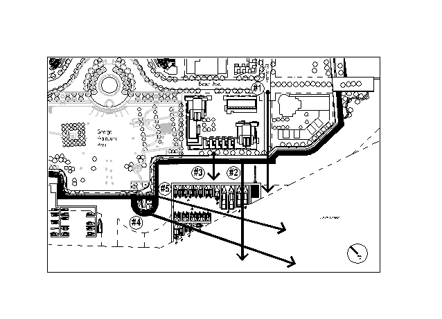 View Locations
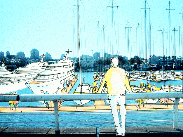
View #2 From the seawall looking south
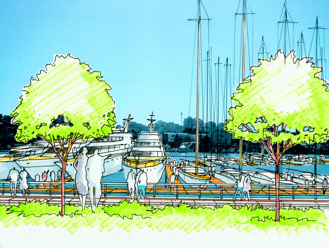
View #3 from Area 1B, Beach Neighbourhood
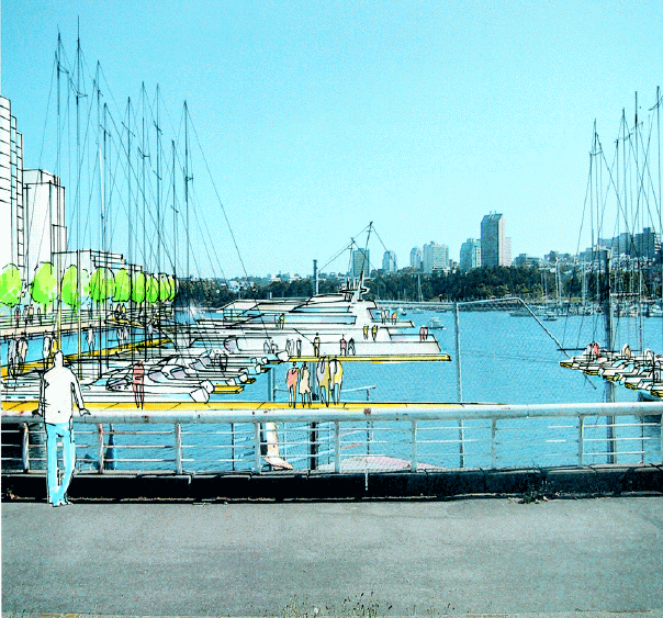
View #5 from Seawall, looking South-east
*****
![[City Homepage]](/graphics/footnava.gif)
|
![[Get In Touch]](/graphics/footnavb.gif)
|

|

|

|
(c) 1998 City of Vancouver