|
|
POLICY REPORT
URBAN STRUCTURE
Date: May 28, 2002
Author/Local: Heather Burpee / 6068RTS NO. 2679
CC File No. 5302
P&E: June 13, 2002
TO:
Standing Committee on Planning and Environment
FROM:
Director of City Plans in consultation with the Director of Current Planning
SUBJECT:
North Burrard C-3A Design Guidelines
RECOMMENDATION
A. THAT Council replace the existing design guidelines for the North Burrard C-3A area with the North Burrard C-3A Guidelines outlined in this report and contained in Appendix A, to guide developments requiring discretionary approvals in the subject C-3A zone ; and
B. THAT Council direct staff to revise the Central Area Plan: Goals and Land Use Policy to more accurately reflect the intent of the Plan for the Burrard Street Corridor (Appendix B).
GENERAL MANAGER'S COMMENTS
The General Manager of Community Services RECOMMENDS approval of A and B.
COUNCIL POLICY
In July 1976, Council adopted the Central Broadway C-3A Design Guidelines which call for the North Burrard area to be primarily an office and city-wide retail district.
In December 1991, Council adopted the Central Area Plan: Goals and Land Use Policy which calls for the area along Burrard Street to be a mixed use/choice of use (including residential) area.
In June 1993, Council adopted the Burrard Slopes C-3A Guidelines which call for the area to be a primarily residential community.
In June 1993, Council adopted the Burrard Slopes IC Districts Interim Policies which allow limited residential use in addition to industrial and limited office, service and retail uses.
PURPOSE AND SUMMARY
The existing design guidelines for the North Burrard C-3A area, contained in the Central Broadway C-3A Design Guidelines, strongly discourage residential use because of the traffic impacts on Burrard Street. This is inconsistent with the Central Area Plan which calls for a choice of use/mixed use, including residential, in this area. Residential design guidelines have also since been developed for other high traffic areas to mitigate the impact on residential development.
The purpose of this report is to present to Council a set of revised stand-alone design guidelines for the North Burrard area which include residential use, to be used in conjunction with the existing C-3A district schedule. The proposed guidelines aim to create livability in new developments, protect views, ensure neighbourliness and enhance street definition and character for the North Burrard area. Area residents, property owners and businesses are supportive of the guidelines if private views are not significantly impacted.
This report also recommends that the Central Area Plan: Goals and Land Use Policy be revised to more accurately portray the intent of the Plan for the Burrard Street corridor as a choice of use/mixed use area, including residential.
BACKGROUND
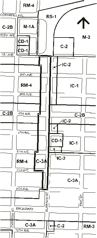
The North Burrard C-3A study area extends from 1st Avenue to 8th Avenue on the west side of Burrard Street (Figure 1). The portion from 1st Avenue to 6th Avenue constitutes the North Burrard sub-area of the Central Broadway C-3A Guidelines, while the remaining portion is part of the Burrard sub-area. The existing guidelines for the North Burrard area do not permit residential development, while those for the Burrard sub-area do.
The C-3A district permits retail, office, service, cultural/recreational and institutional uses. Residential use is also permitted through conditional approval.
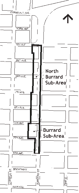
Figure 1. North Burrard C-3A Study Area
The area has a variety of lot sizes and forms of development and extends approximately 36 m (118 ft) deep along Burrard, with a total area of approximately 61,000 m2
(656,600 ft 2). It is characterized by retail, office, and service uses in one to three storey buildings. Some are located at the property line and others are set back with parking in front. Between 6th and 7th Avenues there is a large mixed use development including a three storey commercial/residential building on Burrard and a seven storey residential building on 7th. There are no heritage buildings in the sub-area.The topography slopes down from 8th to 4th Avenues and provides views of the North Shore Mountains and downtown. Four public view cones have been adopted by Council to protect public and private views.
The North Burrard area is adjacent to an RM-4 area, a medium density residential district, to the west (Figure 2). To the east, it faces the Burrard Slopes IC-2 district (from 1st to 6th Avenues) and Burrard Slopes C-3A (6th to 8th Avenues). The Burrard Slopes C-3A area is a primarily higher density residential district with commercial use required at grade on Burrard. The IC area allows light industrial uses and limited service, retail and office uses, in addition to residential use with a rezoning to CD-1. The study area is also adjacent to the C-2B district on both 1st and 4th Avenues. C-2B allows a similar mix of uses as C-3A .
Burrard is a major arterial and entry to downtown. Average daily two-way traffic volumes are 41,000 vehicles on this portion of Burrard. This is less than other arterials with significant residential development, such as Oak (at 21st), Cambie (at 20th) and Kingsway (at Gladstone).
Figure 2. Surrounding Zoning
DISCUSSION
The Central Broadway C-3A Guidelines were adopted in 1976. They call for the North Burrard area to be an office and city-wide retail district given the area's proximity to downtown and lack of pedestrian activity. Despite its adjacency to an RM-4 district, the guidelines specify that residential use (a conditional C-3A use) is not appropriate for thislocation because of heavy traffic noise and exhaust fumes and should be considered a buffer zone between Burrard and the residential area to the west. The Burrard sub-area from 6th to 8th Avenues did not have this restriction.
Since that time land use policy has changed and guidelines have been developed to address livability concerns in high traffic areas. The Central Area Plan: Goals and Land Use Policy, adopted in 1991, identifies this area as suitable for choice of use/mixed use including residential use. Policies have been adopted in the IC-1 and IC-2 areas on the east side of Burrard and the Burrard Slopes C-3A area to reflect the intent of the Central Area Plan. In 1993, the Burrard Slopes IC Districts Interim Policies were adopted to provide for limited residential development upon rezoning to CD-1, although the goal for the area is to maintain its downtown support service role. Guidelines were adopted for the Burrard Slopes C-3A area, also in 1993, to assist in the creation of a primarily residential neighbourhood. The C-3A portion on the west side of Burrard was not addressed given other work program priorities, such as CityPlan and the single family zoning review.
In keeping with the revised land use policy and policies adopted for the east side of Burrard as well as those in place for the C-3A area south of 6th Avenue, staff recommend allowing residential use along the west side of Burrard to make it a choice of use/mixed use area. New developments would generally contain a mix of uses such as commercial at grade facing Burrard, service or office uses above and residential adjacent to the RM-4 district.
The proposed design guidelines have been written as stand-alone guidelines and have been removed from their existing location in the Central Broadway C-3A Guidelines to provide more clarity and ease of use for applicants. The two sub-areas have been combined to provide for consistency on the west side of Burrard.
Livability for Residents
Mitigating the impacts of traffic noise and exhaust fumes are integral to ensuring a high standard of livability for residents and is a key component of the proposed guidelines. This is achieved through:
· not permitting residential use at grade along Burrard;
· orienting private and semi-private space away from Burrard;
· encouraging commercial uses to face Burrard and residential uses to be located behind, next to the RM-4 district; and
· guidelines addressing light and ventilation, privacy and compatibility betweenresidential and non-residential uses.
Livability is also enhanced through acoustic requirements in the district schedule for residential development.Views and Neighbourliness
Assisting new development to be neighbourly with adjacent multi-family housing is another goal of the proposed guidelines. This is to be achieved through:
· a stepped-down envelope for buildings adjacent to the RM district to respond to its 10.7 m (35 ft) maximum height, prevent overlook, allow better sunlight penetration and help maintain private residential views;
· discouraging non-residential uses above the second floor adjacent to the RM district;
· requiring side and rear yard setbacks similar to the adjacent residential buildings; and
· requiring a transitional front yard setback to respond to the adjacent residential buildings.The proposed guidelines permit a maximum height of 13.7 m (45 ft) or five stories (whichever is less) where permitted by the existing view cones. The impact of the view cones is such that portions of some sites south of 3rd Avenue may not achieve the maximum permitted height. This would be confirmed during development permit review. Lots north of 3rd Avenue will likely be able to achieve the height potential for the entire site.
The proposed height limit is slightly higher than the 12.2m (40 ft) limit in the current guidelines in order to improve street definition, allow a reasonable density and form of development within the stepped envelope and provide some incentive for concrete construction. The increased height should be offset by the stepped envelope adjacent to the RM district, which reduces the height to 9.1m (30 ft).
Private views are more likely to be impacted by the permitted heights in surrounding districts. In particular, the C-2B area on 4th and 1st Avenues permits heights of up to 15.3m (50 ft). To the east, the Burrard Slopes C-3A guidelines allow a height of 30.5 m (100 ft) for towers located off Burrard, while the IC areas permit up to 15.3 m (50 ft) for developments off Burrard.
Street Definition and Area Character
The guidelines aim to create an attractive mixed use area and establish a strong streetdefinition to enhance the approach to the Burrard Bridge and downtown Vancouver. They create street definition by allowing buildings on Burrard to achieve a height of 13.7 m
(45 ft) where permitted by view cones and by limiting setbacks and surface parking on Burrard in order to create a continuous street frontage. The IC and C-3A guidelines call for stepped envelopes from 9.1 m (30 ft) high to13.7 m (45 ft)and 15.3 m (50 ft) respectively on the east side of Burrard, where permitted by the view cones. Although the proposed envelope is not identical it will create a unified streetscape with a similar overall height and view cone restrictions on both sides of Burrard.Street and site landscaping guidelines will also enhance the character of the area while allowing residential uses will help to create a more vibrant mixed use area.
Public Consultation
Area businesses, residents, property owners were invited to an open house on April 11, 2002 to discuss the proposed guidelines and changes to the area. In addition to an advertisement in the Courier Newspaper, all property owners, residents and business tenants were mailed an invitation. Eleven people attended and were generally supportive of the guidelines as long as there are no significant impacts on existing private views.
Those who attended the meeting as well as those who requested copies of the draft guidelines were also mailed copies of the final version of the proposed guidelines.
Central Area Plan Map Update
This report also calls for clarification of the policy for this area in the Central Area Plan: Goals and Land Use policy. Although the Plan includes an intent for the Burrard corridor to be a mixed use/choice of use area, according to its authors, the map that accompanies the plan does not indicate a land use option. The map was intended to be general in nature, but clarification for the Burrard corridor would be helpful for both staff and applicants/property owners.
CONCLUSION
Adopting the proposed North Burrard C-3A Guidelines would bring the area into conformity with current land use policy and create a more vibrant mixed use area with a strong street definition and approach to the Burrard bridge and downtown.
* * * * *

![[City Homepage]](/graphics/footnava.gif)
|
![[Get In Touch]](/graphics/footnavb.gif)
|

|

|

|
(c) 1998 City of Vancouver