

|
|
POLICY REPORT
URBAN STRUCTURE
Date: March 5, 2002
Author/Local: P. Mondor/7727RTS No. 02497
CC File No. 5303/5304
CS&B: March 26, 2002
TO:
Standing Committee on City Services and Budgets
FROM:
Director of Current Planning, in consultation with the General Manager of Engineering Services and the Director of the Housing Centre
SUBJECT:
651 Expo Boulevard and 630-690 Beatty Street (False Creek North Area 7B): CD-1 Rezoning and False Creek North Official Development Plan Amendments - Major Planning Issues
RECOMMENDATION
A. THAT Council is prepared to consider the applications by Pacific Place Developments Corp. to amend the False Creek North Official Development Plan and to rezone Area 7B from BCPED to CD-1, such rezoning
(a) to permit a change of use from predominantly office to primarily residential,
(b) to exchange permitted commercial density on Area 7B for permitted residential density on Areas 6A and 6C, and
(c) to permit five residential towers and a Costco Wholesale store;B. THAT Council favours the incorporation of the City-owned Lot D at 696 Beatty Street as part of Area 7B, to be sold to Pacific Place Holdings Ltd., with disposition of the lot to be addressed in a report back from the General Manager of Engineering Services, in consultation with the Director of Real Estate Services;
C. THAT Council is prepared to consider the consolidation on Area 7B of a non-market housing obligation previously transferred from Site 5GH in Area 5A (100 units) and another obligation proposed to be transferred from Area 6C (131 units);
D. THAT Council is prepared to consider the relaxation of parking requirements, but within existing policies and relevant precedents and experience;
E. THAT Council favours the relocation of Stadium Parking Agreement spaces from other sub-areas to Area 7B;
F. THAT Council is prepared to consider an alternative means of providing a direct pedestrian link between Stadium Skytrain Station and BC Place and favours a barrier-free, pedestrian link between Beatty Street or Viaduct level and the lower Expo or Pacific Boulevard level;
G. THAT Council favours that the parking needs of the Drill Hall at 620 Beatty Street be addressed through voluntary collaboration and business arrangement between Pacific Place Developments Corp., the BC Regiment and the City, with staff to provide assistance as may be helpful; and
H. THAT Council encourages Pacific Place Developments Corp. to undertake voluntary reintegration or commemoration of resources on the site of historic interest, but that this is not seen as a requirement of rezoning the site.
GENERAL MANAGER'S COMMENTS
The General Manager RECOMMENDS approval of A through H.
COUNCIL POLICY
· North East False Creek Urban Design Plan, approved July 26, 2001
· False Creek North Official Development Plan, adopted April 10, 1990 and last amended July, 2001
· Central Area Plan, adopted December 3, 1991
· View Protection Guidelines, adopted December 12, 1989 and last amended December 11, 1990PURPOSE AND SUMMARY
Prior to submission of a detailed rezoning application and normal application processing, staff seek Council direction on policy questions raised by an application submitted on November 19, 2001 by Pacific Place Developments Corp. (PPDC) to rezone its site at 651 Expo Boulevard and 630-690 Beatty Street from BCPED to CD-1, and a companion application (yet to be submitted) requesting related amendments to the provisions of False Creek North (FCN) Official Development Plan (ODP) for Area 7B.
The Major Projects Steering Committee has reviewed the proposed FCN ODP amendments and CD-1 rezoning to confirm they are appropriate to consider under established City plans and policies. Based on this preliminary assessment, and without prejudging the outcome of normal application processing yet to be undertaken, staff recommend that Council be prepared to consider the applications. Staff evaluation is underway, and supportive conclusions are anticipated, regarding:
· the proposed change in land use of Area 7B from commercial (predominantly office) to mixed-use (primarily residential),
· the proposed exchange of commercial development potential on Area 7B for residential potential on Areas 6A and 6C, and
· the proposed five residential towers at Beatty Street and Viaduct level and a "Costco Wholesale" store at Expo Boulevard level.City Council guidance is sought regarding several choices:
· the incorporation of the City-owned lot at corner of Beatty Street and Georgia Viaduct within Area 7B,
· the consolidation on Area 7B of non-market housing obligations from Site 5GH (in Area 5A) and Area 6C,
· the relaxation of minimum parking requirements for residential use and the maximum parking provision for the Costco store,
· the Stadium Parking Agreement obligation for 100 built, signed, public use parking spaces on this site, and relocation of spaces from other FCN sub-areas,
· the pedestrian connection between Stadium Skytrain Station and BC Place required by the FCN ODP, and a connection between Beatty Street or Viaduct level and the lower Expo or Pacific Boulevard level,
· the parking needs of the adjoining Beatty Street Drill Hall at 620 Beatty Street, and
· the potential heritage resources on the site, including historic materials from the original Georgia Viaduct's western approach, the Dunsmuir rail tunnel and its portal, and the escarpment.BACKGROUND
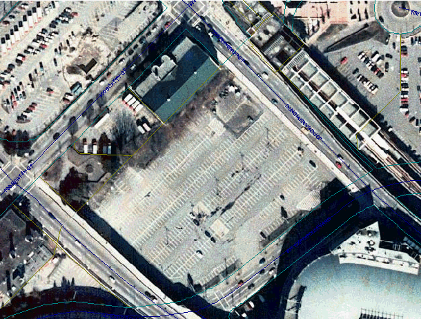
The site, which is designated as Area 7B in the False Creek North (FCN) Official Development Plan (ODP), is located at the eastern edge of the Downtown at the foot of the escarpment to the False Creek lowlands and is generally bounded by Beatty Street, the Georgia and Dunsmuir Viaducts, and Expo Boulevard. It has been used for many years for surface parking (551 spaces). It is 23 820 m² (256,405 sq. ft.) or 2.38 ha (5.9 acres) in area. Excluding area under the viaducts which would be dedicated to the City, net site area is 18 555 m² (199,735 sq. ft.).
The area between the viaducts also contains the Beatty Street Drill Hall (BC Regiment) at 620 Beatty Street, zoned DD, and the irregularly-shaped City-owned Lot D at 696 Beatty Street (corner of Beatty and Georgia Streets), zoned BCPED.
(Note: Appendix A provides additional site and context information, including background information on the False Creek North Official Development Plan and the North East False Creek Urban Design Plan.)
Figure 1. Site and Proposed Development (Site Plan)
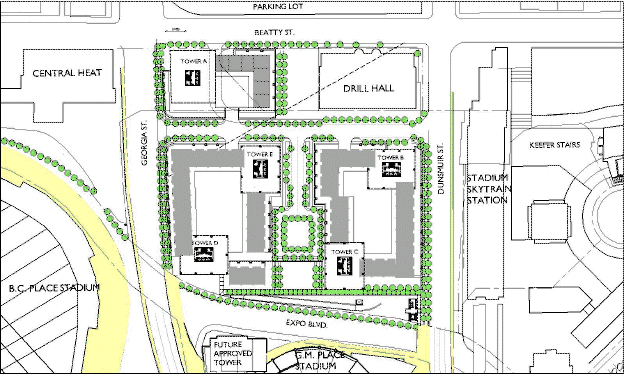
A total floor area of 111 729 m² (1,202,681 sq. ft.) is permitted in Area 7B, representing a gross floor space ratio (FSR) of 4.7 and net FSR of 6.0 (after dedication). Residential development of 98 110 m² (1,056,081 sq. ft.) is proposed in five towers containing 1,100-1,200 dwellings, and 30-40 townhouse dwellings. The towers would range from 21 storeys to 29 storeys. The proposed maximum tower height of 90 m (295 ft.) is within view cone limits.One of the proposed residential towers (Tower A in Figure 1), with a height of 21 storeys, would provide 231 non-market housing units (126 family and 105 non-family), meeting the non-market housing obligation on Area 7B previously transferred from Site 5GH in Area 5A and the proposed transfer of an obligation from Area 6C.
A Costco Wholesale store is proposed at the Expo Boulevard level. It would have a floor area of 13 563 m² (146,600 sq. ft.), representing about 12 percent of total floor area proposed on the site.
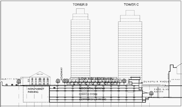
Four levels of parking are proposed: two levels of retail parking below the Costco store, and two levels of residential parking above the store. A roadway through the site is proposed, parallel to Beatty Street and at viaduct level, with signalized intersections at Dunsmuir and Georgia Viaducts. (See Additional Application Information in Appendix B.)
Figure 2. Proposed Development (Cross-Section)
DISCUSSIONA. Proposed Land Use Change and Development
Staff evaluation of the proposed land use change and development in Area 7B is underway and these elements of the application are likely to be supported by further analysis and continued public input.
(a) The proposed change in land use of Area 7B from commercial (predominantly office) to mixed-use (primarily residential) has been discussed for about two years now and was recently endorsed in principle in the North East False Creek Urban Design Plan approved by City Council in July, 2001. In this context, assessment of residential livability is a priority staff focus.
(b) The proposed exchange of commercial development potential on Area 7B for residential potential on Areas 6A and 6C can be contemplated on the basis that the overall land use mix in FCN would be maintained, although how commercial potential will be realized on Areas 6A and 6C remains an outstanding question.
(c) The"Costco Wholesale" store at Expo Boulevard level appears to be a suitable use and development for an awkward and difficult part of the site. Also, the proposed Costco store so near the downtown might have some potential benefits in terms of goods movement, producing a net trip reduction which will have environmental benefits. Unlikely to compete directly with established retail stores in the Central Area, Costco will in fact serve many small retailers and could draw customers to the Gastown and Chinatown neighbourhoods.
A process of public involvement has been underway since the application was submitted and public input to date is generally supportive of the proposed uses and development, including the Costco store. (See more information on Public Involvement in Appendix C.)
B. City-Owned Lot D at 696 Beatty Street
The City owns a small, irregularly-shaped lot at the north corner of Georgia and Beatty Streets. It was rezoned from DD to BCPED in 1984, but is not within the False Creek North (FCN) Official Development Plan (ODP) boundary and not part of Area 7B. The lot was part of the right-of-way for the original Georgia Viaduct's western approach and is now developed as a commemorative plaza overlooking the escarpment between the Downtown and the False Creek lowlands. Staff note that Pacific Place Holdings Ltd. owns the sub-surface rights of the lot, including the rail tunnel and its portal.
The plans submitted with the application incorporate the City-owned lot within the portion of Area 7B proposed for non-market housing and its below-grade parking. The applicant proposes to exchange a portion of its site adjacent to the Beatty Street Armoury for the City-owned lot, to provide public open space and some surface parking for the BC Regiment's Drill Hall. Staff do not support this approach.
Staff strongly urge that Lot D be incorporated within the development site, because its role as an escarpment overlook would be lost when area 7B is redeveloped to meet Beatty Street grade and Viaduct level. Staff propose that the lot be sold to Pacific Place Holdings Ltd. A report from the General Manager of Engineering Services, in consultation with the Director of Real Estate Services, is being prepared prior to rezoning referral to address disposition of the lot, including price and form of payment.
C. Non-Market Housing
Area 7B has an obligation through a Non-Market Housing Agreement, which was transferred from Site 5GH in Area 5A last year, to provide a site for 100 non-market housing units. The proposed transfer of residential density on Area 6C to Area 7B would transfer another non-market housing obligation, for 131 units. The consolidation of these would result in a 231-unit building, representing 15 to 20 percent of all dwellings on the site, which the applicant proposes as a 21-storey tower at the west corner of the site. A larger project makes sense in the context of the five towers proposed for 7B, however a 231-unit project will be more difficult to fund than the two smaller projects previously approved for Areas 7B and 6C. Pacific Place Holdings Ltd. may be required to contribute to the cost of the project to ensure that it is competitive for the limited funding available. This will be addressed through the detailed discussion leading up to rezoning referral.
D. Parking
The application proposes less parking than is required in residential developments, and more parking for the Costco Wholesale store than would be permitted for a retail store or grocery store. Staff assessment of the requested relaxation of the minimum residential parking requirements will take account of the site's proximity to Downtown and Skytrain, the significant share of households on the Downtown peninsula which do not own a vehicle, and the dwelling composition (unit size mix) of proposed development. It appears that the applicant will have to provide more residential parking than is presently proposed.
A relaxation is also requested to exceed the maximum permitted retail parking provision for the Costco store. Staff assessment of this will take into account the unique characteristics of this retail use and the nature and duration of trips to this store. While Costco proposes a parking standard significantly reduced from what it provides for its more typical suburbanstores, it is still somewhat high relative to the City's grocery store minimum requirement. Conceivably, if Costco is willing, some of its shortfall might be met through the provision of additional Stadium Parking spaces on Area 7B (see more discussion immediately below).
E. Stadium Parking
Area 7B has an obligation to provide 100 public use, signed, parking spaces under the terms of the Stadium Parking Agreement. The applicant prefers to provide these in other FCN sub-areas. Staff believe that the site is the ideal location for these spaces.
Furthermore, as sites surrounding BC Place are developed, this site, so near BC Place and GM Place, could be the ideal long-term location for some of the 800 parking spaces which must be maintained under the terms of the Stadium Parking Agreement. Staff encourage the applicant, in consultation with B.C. Pavilion Corporation (Pavco), to relocate Stadium Parking spaces to this site from other FCN sub-areas.
F. Pedestrian Infrastructure and Circulation
The FCN ODP intends that development be an integral part of the city rather than self-contained, through extension of key elements of the street grid as streets, pedestrian routes and vistas. The ODP also intends that a variety of means of moving through the area be provided, including streets, walkways, bicycle routes, transit and ferries. With respect to Area 7B, the ODP has a requirement for an elevated pathway from Stadium Skytrain Station through Area 7B to the BC Place concourse. Pedestrian access from Georgia Viaduct grade to the BC Place concourse, about 2.4 m (8 ft.) below, could be a challenge to achieve.
The NEFC Urban Design Plan proposes several pedestrian improvements, the principal one near Area 7B being a barrier-free connection between Beatty Street and Pacific Boulevard, on the south side of the Georgia Viaduct and down to the easterly Stadium concourse. This would require the co-operation or participation of Pavco and Central Heat over whose lands a pedestrian link between the Georgia Viaduct and BC Place concourse would need to be located. Pavco's co-operation has been offered in conjunction with the proposal (on hold since July, 2001) to increase non-residential floor area in Area 10 (Stadium Site).
Changing the land use of Area 7B from predominantly office to primarily residential raises questions about the best alignment for the required pathway from Skytrain Station to BC Place. Occasional heavy pedestrian traffic related to BC Place events has potential to disrupt the residential neighbourhood. Staff believe it is essential that pedestrian movement between Stadium Skytrain Station and BC Place be served, but there might be alternative ways of achieving this link than the specific configuration set out in the FCN ODP.
Staff also believe that pedestrian movement should be facilitated between the Beatty Street or Viaduct level and the lower grade at Expo and Pacific Boulevards. The options are limited for achieving this improved linkage on the site between the Viaduct and Boulevard levels, like the Keefer Steps north-east of Stadium Skytrain Station. A comprehensive solution might conceivably include the barrier-free pedestrian connection on the south side of the Georgia Viaduct from Beatty Street to BC Place concourse and then down to Pacific Boulevard, which is proposed in the NEFC Urban Design Plan, although such a linkage would not be on Area 7B.
G. Beatty Street Drill Hall
Abutting the site, at the corner of Dunsmuir Viaduct and Beatty Street, is the Beatty Street Drill Hall at 620 Beatty Street, occupied by the BC Regiment. The Drill Hall is a heritage building (Evaluation Group `A') and is municipally-designated. The 2 230 m² (24,000 sq. ft.) site has very high site coverage and no parking. After the sale of the abutting Lot 7, where Drill Hall vehicles were previously parked, the BC Regiment leased a portion of Area 7B providing 30 parking spaces. These spaces would be lost through redevelopment.
Staff believe that every attempt should be made to address the Drill Hall's parking needs. There is precedent for providing off-site parking to serve parking-deficient heritage buildings. City Council also resolved the following at its meeting of April 18, 2000 which indicates a public interest to be served by addressing Drill Hall needs during the rezoning of Area 7B:
... AND WHEREAS it is evident that developments which may be planned to the immediate South and East of the Drill Hall can be so ordered as to complement, and indeed enhance, the operations of the Regiment and the physical integrity of the building;
... THEREFORE BE IT RESOLVED THAT the Mayor and Council of the City of Vancouver express full support for the retention of the British Columbia Regiment in the Beatty Street Drill Hall ... [excerpts only]The BC Regiment has indicated a need for 30-40 parking spaces, although the Parking By-law provisions would contemplate 17-24 spaces for the uses accommodated in the heritage building. The question is where these spaces are to be provided and who will provide them. The applicant states it is not possible to provide more parking than is already proposed on Area 7B, unless it is surface parking provided on site area adjacent to (east of) the Drill Hall. City policy definitely does not support surface parking.
Staff have identified and are exploring various physical alternatives for meeting Drill Hall parking needs (e.g., in the area below the viaducts which is to be dedicated to City, or on Block 48 across Beatty Street). However, the Drill Hall property is not in FCN and is not addressed in the FCN ODP principles or requirements, and therefore raises no obligations for the property owner in this respect. It seems therefore that any parking for the Drill Hall on Area 7B would have to come from a voluntary collaboration and business arrangement between Pacific Place Developments, the BC Regiment and perhaps the City. Staff will continue to provide assistance, as might be helpful, to achieve such an arrangement.
In case a voluntary business arrangement is not likely and Council wants some options for consideration, (a) the City might seek to purchase parking spaces on the site and lease them to the BC Regiment, and/or (b) the applicant could be requested to make arrangements to provide some Drill Hall parking as a condition of rezoning approval. However, regarding the latter option (b), it is notable that this would represent an obligation on the property owner over and above those originally established with the adoption of the FCN ODP.
H. Potential Heritage Resources
In a letter dated November 29, 2001, Heritage Vancouver, a heritage advocacy group, has identified potential heritage resources on the site, including the rail tunnel and its portal, the escarpment, and historic materials from the original Georgia Viaduct's western approach which were incorporated in the commemorative plaza at the Beatty Street level of the City-owned Lot D. The letter acknowledges that retention or commemoration of these heritage resources was not established in the original FCN rezoning, but that the current rezoning application could be a timely opportunity to explore creative alternatives for them.
None of these potential resources are on the Vancouver Heritage Register. Staff also believe that development of Area 7B to meet Beatty Street and Viaduct grade makes retention of the escarpment, rail tunnel and portal impractical and difficult. Nevertheless, staff propose to investigate the heritage resources, in assistance to Pacific Place Developments Corp., which is encouraged to undertake voluntary reintegration or commemoration of these resources within proposed new development on the site where this is practical.
APPLICANT'S COMMENTS
Comments from the applicant, Pacific Place Developments Corp., is attached as Appendix D.
CONCLUSION
After City Council advice on these policy issues has been heard, through its consideration of the staff recommendations in this report, the applicant would submit a revised application. Review by the Urban Design Panel and a further round of public consultation are proposed for March and April. Rezoning referral report is targeted for mid-May and Public Hearing in June, so that rezoning, if approved, can be enacted within this term of Council.
* * * * *
![]()
ADDITIONAL BACKGROUND INFORMATION
Appendix A
Site, Surrounding Zoning and Development: The site which is located at the eastern edge of the Downtown is generally bounded by Beatty Street, the Georgia and Dunsmuir Viaducts, and Expo Boulevard, and has been used for many years for surface parking (551 spaces). The site is 23 820 m² (256,405 sq. ft.) or 2.38 ha (5.9 acres) in area. Excluding area under the viaducts, which would be dedicated to the City, the net site area is 18 555 m² (199,735 sq. ft.).
Figure 1. Site and Surrounding Zoning
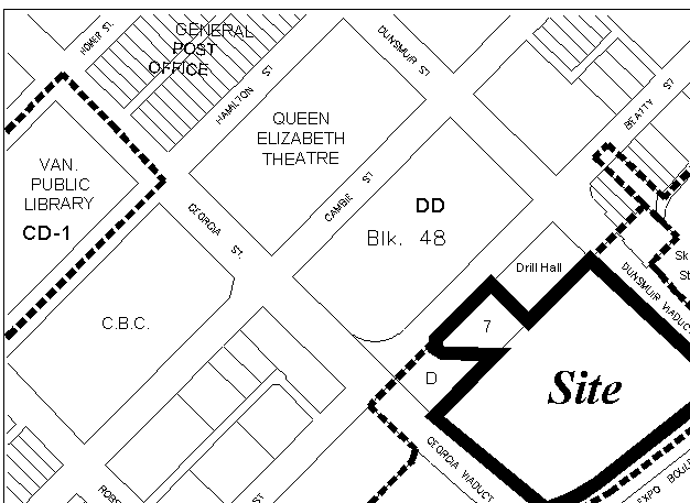 The area between the viaducts also contains the Beatty Street Drill Hall at 620 Beatty Street, zoned DD, and the City-owned Lot D as 696 Beatty Street, zoned BCPED.
The small Lot D at the north corner of Georgia and Beatty Streets is a City-owned capital asset (not in Property Endowment Fund). The irregularly-shaped lot has an area of 1 530 m² (16,468 sq. ft.). It was zoned from DD (FSR 5.0) to BCPED in 1984, but is not within the False Creek North Official Development Plan boundary and is not part of Area 7B. The site is situated on the escarpment between the Downtown and the False Creek lowlands, and the base of the 13.4 m (44 ft.) escarpment is generally within the lot boundaries as is the last 30 m (100 ft.) of the decommissioned rail tunnel and its portal.
The lot was part of the right-of-way for the original Georgia Viaduct's western approach. It is now developed as public open space in the form of a plaza overlooking the escarpment created to commemorate the original viaduct structure (completed in 1915) after it was demolished in 1970. Some of the historic materials from the original viaduct were saved and reused, including concrete railings with grille motif surmounted by lamps on concrete posts.
The CPR tunnel, constructed in 1932 and decommissioned, sealed and transferred to the Province in the early 1980s, extends from the Dunsmuir Street tunnel adapted for the Skytrain line, across Block 48 ("Larwill Park" site), Beatty Street, and, for its last 60 m (200 ft.), across PPDC's Lot 7, and City-owned Lot D where it terminates with a portal. The tunnel is owned by PPDC under both its Lot 7 and Lot D, and is rented occasionally to the movie industry.
Figure 2. Existing Development
False Creek North Official Development Plan: The False Creek North (FCN) Official Development Plan (ODP), adopted in April 1990, anticipates that FCN will be developed as a predominantly residential area. Up to 9,197 dwelling units would be developed, in a total residential floor area of 906 015 m² (9,741,032 sq. ft.). The ODP also provides for a maximum of 158 610 m² (1.7 million sq. ft.) of floor area in office use and street- or pedestrian-oriented retail and service uses.
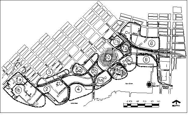
Figure 3. False Creek North Sub-Areas
 The ODP originally provided for 111 480 m² (1.2 million sq. ft.) of floor area on Area 7B which is described in the ODP as a "predominantly office area". As a result of the rezonings of and density swaps with Site 5GH and the Gap site in Area 5A which were approved and enacted in 2001, the commercial (office) potential on Area 7B was reduced to 87 670 m² (943,700 sq. ft.) and a residential potential of 24 061 m² (259,000 sq. ft.), including a non-market housing obligation of 100 units, was added.
Placing residential potential on Area 7B, which remained zoned BCPED, was described to City Council as a temporary measure pending the outcome of the North East False Creek urban design study, particularly its determination as to whether residential use would be suitable in a mixed-use Area 7B.
North East False Creek Urban Design Plan: Early in 2000, the NEFC Urban Design Study was initiated to review the northeast sector of FCN. The study area was bounded by Beatty Street, Nelson Street, False Creek, Quebec Street and the Dunsmuir Viaduct, and the study involved the participation of the various landowners in the area including Pacific Place Developments, Stadium Pavilion Corp. (Pavco) and Plaza of Nations.
The intent of the study was to find ways to improve the public realm and built form guidelines, adjust land use and density, and increase the integration of the area into the Downtown, all within the overall existing density limits for various land uses within the FCN area. This would refine its urban development pattern to reflect changed conditions since the ODP was approved more than a decade ago.
In July 2001, City Council approved the NEFC Urban Design Plan and referred several ODP amendments to Public Hearing:
· to designate Area 7B as a "mixed residential-commercial area",
· to transfer 27 870 m² (300,000 sq. ft.) of commercial potential from Area 7B to Area 5B, over and above its existing commercial potential of 18 500 m² (200,000 sq. ft.),
· to allow for `choice of use' on Site 5EF in Area 5A by allowing transfer of up to 37 160 m² (400,000 sq. ft.) of residential potential from Site 5EF to Area 7B, and 41 805 m² (450,000 sq. ft.) of commercial potential from Area7B to Site 5EF,
· to allow for `choice of use' in Area 6C by allowing a swap of up to 66 889 m² (720,000 sq. ft.) of residential potential in Area 6C for commercial potential in Area7B, and
· 49 330 m² (531,000 sq. ft.) of new non-residential density for additions to BC Place Stadium and a package of public amenities and infrastructure.
In a very central feature of the plan, the Cambie Bridgehead area was envisioned as a mixed-use commercial-residential precinct extending the Yaletown character, rather than a predominantly residential precinct. Area 7B, where most of the office potential in NEFC is located, was proposed to become a predominantly residential area, with mid- to high-rise residential development and some commercial uses at grade. The suitability of Area 7B for residential use, in terms of livability and impacts, was proposed to be more definitively evaluated through detailed consideration of a rezoning application for Area 7B.
Public hearing to implement the NEFC Urban Design Plan was subsequently put on hold pending the outcome of Pavco's provincial review, and Pacific Place Developments did not wish to proceed without the participation of Pavco.
* * * * *
![]()
ADDITIONAL APPLICATION INFORMATION
Appendix B
Proposed ODP Amendment: The FCN ODP amendment proposed in this application would reduce the commercial potential of Area 7B from 87 670 m² (943,700 sq. ft.) to 13 563 m² (146,600 sq. ft.) and increase the residential potential from 24 061 m² (259,000 sq. ft.) to 98 110 m² (1,056,081 sq. ft.). This is the equivalent of changing 74 050 m² (797,100 sq. ft.) from commercial use to residential use.
Density swaps with two other sub-areas are proposed for achieving this: commercial potential of 74 050 m² (797,100 sq. ft.) would be transferred to Area 6C and residential potential of 66,889 m² (720,010 sq. ft.) from Area 6C and 7 31 m² (79,990 sq. ft.) from Area 6A would be transferred to Area 7B.
The property owner's obligation to provide a site for 100 non-market housing units (50 family and 50 non-family), previously transferred from Site 5GH in Area 5A, would be increased by the proposed transfer of an obligation to provide a non-market site for 131 units (55 non-family and 76 family) in Area 6C.
Proposed CD-1 Rezoning: The proposed rezoning from BCPED to CD-1 would permit the following development on this large site: (also see Figure 4 on the following page)
· a total floor area of 111 729 m² (1,202,681 sq. ft.), including 98 110 m² (1,056,081 sq. ft.) in residential use and 13 563 m² (146,600 sq. ft.) in retail use;
· residential development: five towers containing 1,100 - 1,200 dwellings, and 30 - 40 townhouse dwellings, with access/egress on Beatty Street and the Georgia and Dunsmuir Viaducts. The towers would range from 22 storeys to 29 storeys. Maximum tower height would be 87.8 m (288 ft.), within view cone limits (False Creek View Cones E.1 and E.2 on the Cambie Bridge and Outlying Area View Cones 9.1 and 9.2 at Cambie Street and 10th/11th Avenue and Cambie and 12th Avenue.);
· non-market housing: one of the proposed residential towers, with a height of 22 storeys, would provide 231 non-market housing units (126 family and 105 non-family), meeting the non-market housing obligation on Area 7B previously transferred from Site 5GH in Area 5A and the proposed transfer of an obligation from Area 6C;
· commercial development: a 13 563 m² (146,600 sq. ft.) "Costco Wholesale" store at the Expo Blvd. grade, representing 12 percent of total floor area proposed on the site;
· a roadway through the site, parallel to and east of Beatty Street, at viaduct level, with signalized intersections at Dunsmuir and Georgia Viaducts; and
· open space (public, semi-public, and private), sidewalk improvements surrounding the site, and pedestrian improvements including a stair connection from Dunsmuir Viaduct level to meet Expo Blvd. level at the north-east corner of the site, and also at this corner an elevator linking the two levels.
Further to the rezoning application submitted November 19, 2001, the applicant subsequently advised staff, in a letter dated December 19, 2001, of the following refinements to the proposed rezoning:
· that a portion of the site adjacent the Beatty Street Drill Hall be exchanged for the City-owned, 1 530 m² (16,468 sq. ft.) Lot D at the corner of Georgia and Beatty Streets (addressed as 696 Beatty Street) to provide open space for the Drill Hall which has none. It is also proposed to allocate a portion of the property owner's public art assessment to create a commemorative art piece for the Drill Hall;
· given that the property owner's current lease of surface parking area to the Drill Hall will end, that surface parking could be provided through lease arrangement, in the area adjacent to (east of) the Drill Hall;
· that the Stadium Parking Agreement obligation for 100 built public parking spaces on the site be transferred to another site in FCN;
· that part of the Stadium Parking Agreement obligation for 150 payment-in-lieu parking spaces on the site be applied to a pedestrian stair connecting the Dunsmuir Viaduct and Expo Blvd. levels; and
· that site area beneath the viaducts, 5 255 m² (56,565 sq. ft.) or 22.2 percent of gross site area, which must be dedicated to the City, be used to provide access and egress, and loading and parking, through easement or lease from the City.
* * * * *
![]()
PUBLIC INVOLVEMENT
Appendix C
Notification: Two information signs were installed on the site and 541 notification letters were mailed in early December, 2001.
Public Meetings: Several meetings have been held between the applicant, city staff and the following groups:
· adjacent major landowners, including owners of BC Place Stadium, GM Place, Central Heat, and International Village (December 3, 2001),
· Gastown/Chinatown Downtown East Side Community Groups (December 4, 2001),
· Chinatown Revitalization Group Meeting ( December 10, 2001),
· Board of Trade (January 17, 2002), and
· Chinatown Merchants Association (February 4, 2002).
At the meeting with adjacent property owners, some concerns were expressed about parking and traffic, especially truck drop off that might be generated from the Costco wholesale store at Expo Boulevard. The stakeholders are keen to see the results of the applicant's parking and traffic impacts study.
At the Gastown/Chinatown Downtown Eastside community group meeting, questions revolved around potential employment opportunities at Costco for lower-income people in the Downtown Eastside and retail impacts to Chinatown businesses. The Chinatown Revitalization committee also posed questions about retail impacts on adjacent business areas and are interested in seeing the results of the retail impact study. Some members of the Chinatown Merchants Association expressed concern about the Costco proposal, while others anticipated spill-over benefits from larger numbers of people coming to the general vicinity. Many were keen to see an improved pedestrian environment and wayfinding to Chinatown.
The Board of Trade raised concerns that the downtown's commercial land supply be safeguarded. While they do not oppose the mixed use development proposal for Area 7B, they support maintaining overall ratios between residential and commercial densities in False Creek North.
Public Open House: An open house was held on Saturday, February 9, 11 am to 5 pm, at the Vancouver Public Library. Property owners within three blocks of the site were notified by mail of this event and advertisements placed in downtown community and business newspapers. More than 300 people walked through the display area, and 60 completed a comment sheet (44 percent live within 5 blocks of the site, and 42 percent in the CentralArea). A review of comment sheets indicates that 88 percent of those who commented support the change of use from commercial to residential, 82 percent support the proposed Costco store, 75 percent support the proposed high-rise form of development with low-rise buildings at the street edges. Considerable and helpful commentary was provided regarding desired pedestrian improvements.
Things which people liked about the proposal could be grouped under these topic areas:
- improvement in the area
- connections between areas
- residential use
- residential density
- commercial use (Costco store)
- added activity
- design
Things which people did not like:
- loss of heritage
- design
- livability (townhouses at grade, construction noise)
- lack of pedestrian improvements / pedestrian connections
- lack of green space
- Costco store
- land use (prefer expanded convention facilities)
Suggestions included:
- parking improvements
- other land uses should be included
- pedestrian linkages
- add green space
- residential use
- small retail stores
- remove viaducts
A further round of public consultations, including an Open House, are proposed in late March and early April after submission of a revised, more detailed application.
* * * * *
![]()
APPLICANT'S COMMENTS
Appendix D
With the involvement and cooperation between City staff, Concord Pacific and Costco Wholesale, we have been working to address the issues identified in this report. The 7B site poses a number of unique challenges and opportunities. Overall we are very supportive of this Issues Reports and we are continuing to work with staff to resolve these remaining issues. We would like to make the following comments.
Unique Mixed-Use Development
We are proposing a unique mixed-use development creating a very vibrant, livable and pedestrian friendly residential neighbourhood on top of a Costco Wholesale outlet that will serve the needs of local businesses and residents. The project will provide a key link between the downtown and the False Creek waterfront. It will also help to stimulate the continuing development of the nearby neighbourhoods including International Village and Chinatown.
Beatty Street Drill Hall
We are very supportive of the heritage Drill Hall and the important role of the BC Regiment. The hall has no on-site parking and little funding to secure its long-term parking needs. We are continuing to work with the Drill Hall and City staff to achieve a reasonable and appropriate long-term solution for the Drill Hall that may involve the City owned Lot D.
Parking
Less Overall Parking
The parking solution we are proposing for 7B is unique. Conceptually we are proposing less residential parking and more commercial parking than would normally be required. This results in less overall parking on 7B than would normally be required for these proposed uses. A brief rationale for the parking is outlined below.
· Residential
Accessibility & Affordability: The proximity to the adjacent Stadium Skytrain station combined with a short walking distance to the downtown core, supports a residential parking standard similar to the adjacent Downtown South. This will also help to increase housing affordability. We are working with City staff to determine the right amount of residential parking.
· Commercial
Costco Wholesale on 7B will fill an important niche in the downtown area. Currently Costco's members are travelling out of the downtown area to outlets on the boundaries of the City. The 7B location will satisfy this need and provide significant spin off benefits to the City. Costco has identified the parking it will need and is working with Staff to determine the right amount of parking. The following information is provided in support of the requested parking.
Unique Shopping Characteristics: Costco sells large products in bulk that require a vehicle to transport. Compared to a grocery store, members tend to make less frequent trips of a longer duration. The current proposal already contemplates fewer parking stalls than would otherwise be proposed for a conventional Costco location.
Costco Parking: The Staff proposal to include as part of Costco's parking some of the Stadium Parking is being considered although there are associated operational problems. Costco has a well-proven parking demand that should be adequately provided so that it has a positive impact on the neighbourhood and not negatively impact the surrounding roadways and businesses.
Net Trip Reduction: Costco on 7B will create a net trip reduction of over 5 million km per year currently travelled through the City to their existing outlets. This will result in a savings of approximately 800,000 litres of fuel per year, and a significant positive environmental impact through a reduction in emissions of 22,000 kg per year.
Non-Commuter Parking: Almost 70% of the Costco sales will be to local businesses. This type of parking is considered "pass-by" parking - for vehicles already in the downtown area and will not be used to accommodate commuter parking.
Affordable Housing
PPDC has developed 436 non-market homes through a partnership with the City and the Province. We remain committed to providing affordable housing but are concerned about the continued commitment and participation of the Province. We expect that innovative solutions will be required to continue the provision of affordable housing.
* * * * *
![]()
![[City Homepage]](/graphics/footnava.gif)
|
![[Get In Touch]](/graphics/footnavb.gif)
|

|

|

|
(c) 1998 City of Vancouver