|
|
ADMINISTRATIVE REPORT
Date: November 5, 2001
Author/Local: S. Brown/
604-873-7693
RTS No. 1772
CC File No. 5553
T&T: December 11, 2001
TO:
Standing Committee on Transportation and Traffic
FROM:
General Manager of Engineering Services
SUBJECT:
Proposed Inverness Bike Route
RECOMMENDATION
A. THAT the Inverness bike route be constructed as detailed in this report at a total cost of $700,000 funded from order 30003082 (CA2EA2E) Bicycle Network Unappropriated Account and order 30002963 (CA1EA2E) Bicycle Network 2000 Basic Capital Budget
B. THAT the annual signal maintenance budget be increased by $6,000, the annual streets maintenance budget be increased by $4,500 and the sign maintenance budget be increased by $2,000, all without offset and subject to 2003 Budget Review, for the maintenance of three new cyclist /pedestrian signals, 9 new traffic circles, one set of curb extensions and one-way closure and approximately 61 new bicycle route and traffic control signs along the new bike route, starting in 2003.
C. THAT an application be made for cost-shared funding under the 2001/2002 Cycling Network Program in the event that the program is maintained.
POLICY
Council approved the 1999 Bicycle Plan which outlines the goal to develop the bicycle network to ensure a grid of bikeways approximately 1km apart.
Council approved the Vancouver Transportation Plan that emphasizes the need for developing more bikeways and ranks cyclists second priority after pedestrians.
Council approved the recommendations of the 1992 Bicycle Network Study in which the major recommendation was the priority to integrate bicycles on local streets through the construction of locally integrated bikeways.
SUMMARY
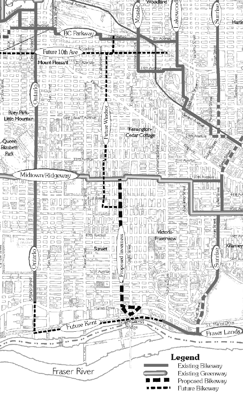
In consultation with residents in the Sunset Neighbourhood and the members of the Bicycle Advisory Committee to Council, a proposal for the Inverness Bikeway was developed. The bikeway follows Inverness Street from the existing Midtown/ Ridgeway Bikeway to Marine drive, providing a critical North/ South connection to the Knight Street Bridge and to the future Kent Avenue Bikeway. Without this proposed route, there is a gap of over 20 blocks (4km) between the Sunrise Bike Route and the Ontario Bike Route for North/ South movements in the Southeast portion of Vancouver.
It is proposed that some intersections be modified for additional comfort and safety of cyclists and that cyclists be given appropriate priority along the route. Traffic calming measures such as traffic circles, corner bulges and diverters are recommended to discourage vehicle short-cutting and speeding. Pavement upgrades are recommended at several locations along the route to improve the riding surface. Signals are proposed at a number of arterial streets to help enhance crossing safety.
The total cost for the Inverness Bike Route project is estimated at $700,000. In the event that the Provincial Cycling Network Program is maintained, an application will be made to receive up to $200,000 towards the cost of constructing the route. However, due to the uncertainty of the future of the Cycling Network Program, it is recommended that construction of the proposed route NOT be postponed to wait for this funding.
Based on support from the Bicycle Advisory Committee, participants at the open house, and resident surveys, staff recommend that the proposed Inverness Bike Route, as detailed in this report, be approved.
PURPOSE
This report seeks approval for the implementation of the Inverness Bike Route.
ROUTE DESIGN
Inverness Street was selected for the development of a bikeway due to its proximity to Knight Street, which would allow for a north-south connection between the Midtown/Ridgeway Greenway and the Knight Street Bridge. Currently the Cypress Bikeway provides a good route to the Granville and Oak Street Bridges, but the Ontario and Sunrise Bikeways do not provide a route within close proximity to the Knight Street Bridge. This route will help to fill this void and reduce the distance between adjacent routes. Also, the spacing between north/south routes in south- east Vancouver is over 4km; which is much greater than the ultimate goal for route spacing of 1km.
As shown in Figure 1, the proposed Inverness bike route extends from the Ridgeway Bikeway along Inverness Street (one of the few continuous streets in this area) to the Knight Street Bridge.
There are a number of measures along the proposed bikeway to help reduce vehicle speeds and to help cyclists cross busy arterials. The following provides a summary of the proposed measures and recommended locations.
Traffic Circles would be installed at the following intersections along Inverness Street to help reduce vehicle speeds and increase intersection safety:
· 39th Avenue
· 43rd Avenue
· Waverly Avenue
· *51st Avenue
· *53rd Avenue
· 54th Avenue
· 60th Avenue
· 61st Avenue
· 63rd Avenue*The traffic circles at 51st Avenue and 53rd avenue were not included on the original survey that was distributed to residents along the bike route. However, it was expected that, due to the largely positive response by residents to other proposed traffic circles along the route, these circles would also be accepted by residents. To verify this, a notice was delivered to all residents on the streets adjoining the proposed traffic circle locations (51st Avenue and 53rd Avenue) to update them and let them have a chance to express any concerns to staff. Phone calls by residents and discussions with residents during field visits confirmed this acceptance.
FIGURE 1: Inverness Bike Route General Alignment
Corner Bulges would be installed at the intersection of Inverness and 57th Avenue to help reduce the crossing distance. This crossing does not currently warrant a signal, but corner bulges will help to improve the ease of crossing at this location.
A Partial Closure would be installed at the intersection of Inverness and 57th Avenue. This closure would restrict vehicles from entering the south leg of the intersection and should help to reduce cut-through traffic in this neighbourhood. This measure received approximately 56% approval in the survey, and will be installed on a temporary 6 month trial basis with monitoring of traffic volumes on nearby streets. After this trial period, residents within the neighbourhood will be surveyed again to obtain their opinion of the partial closure.
Cyclist/Pedestrian Activated Signals would be installed at the following intersections with Inverness Street to help increase the ease of crossing
· 41st Avenue
· 49th Avenue
· SE Marine DriveThere are a number of changes proposed to help improve the connection to/from the Knight Street bridge. These improvements are in the form of
· lane markings on the ramps to the bridge
· a shared bus-bike lane on the northbound to westbound ramp and along SE Marine Drive
· a bike path connecting from the bus bay under the Knight Street overpass of SE Marine Drive to the laneway adjacent to the southbound to westbound ramp from Knight Street
· Signing and marking to guide cyclists from the laneway back to InvernessNEIGHBOURHOOD CONSULTATION
Input from the affected neighbourhood was gathered through a survey and public open house. Approximately 1,500 surveys were sent out to residents within two blocks on either side of the bike route to obtain their opinion on the proposed measures and a response rate of 21% was achieved. The survey form and a summary of the responses is provided in Appendix A and a summary of the comments is provided in Appendix B. The Bicycle Advisory Committe has endorsed this route.
ROUTE SIGNAGE
The signage will be similar to what has been successful on other bike routes throughout the city. All are based on the use of clear internationally recognised standard symbols with minimum wording. The route markers will be placed approximately 2 blocks apart with signs and stencils placed near the intersection with arterial streets. As well, replacement street name signs that include a bicycle logo and new bicycle pavement markings will be installed along the length of the new route.
FINANCIAL IMPLICATIONS
The total cost of the Inverness Bike Route will be $700,000 for route signage, signals and construction of traffic calming measures along the route. There should also be an increase to the annual signal maintenance budget ($6,000) for signal maintenance, the annual streets maintenance budget ($4,500) for maintenance of traffic circles along the route and $2,000 for the annual sign maintenance budget all without offset, starting in 2003 and subject to the 2003 Budget Review.
This project was to be submitted for cost sharing under the Province's Cycling Network Program.
However, the Cycling Network Program is currently being reviewed, and the future of this program is uncertain. In the event that the Cycling Network Program is maintained, an application will be made to receive partial funding for this route.Order 30003082 (CA2EA2E) will be used to fund the construction. If a grant from the Cycling Network Program is not available, any overrun will be provided from order 30002963 (CA1EA2E) when the 2000-02 Capital Plan is closed.
* * * * *

NOTE FROM CLERK - Appendices A and B are not available in electronic form - on file in the Office of the City Clerk.
Comments or questions? You can send us email.
![[City Homepage]](/graphics/footnava.gif)
![[Get In Touch]](/graphics/footnavb.gif)


(c) 1998 City of Vancouver