POLICY REPORT
URBAN STRUCTURE
Date: July 10, 2001
Author/Local: Michael Gordon /873-7665
RTS No. 2161
CC File No. 8204
P&E: July 26, 2001
TO: |
Standing Committee on Planning and Environment |
FROM: |
The Director of Current Planning and the General Manager of Engineering Services, in consultation with the Director of the Housing Centre and the Director of Legal Services |
SUBJECT: |
Northeast False Creek Urban Design Plan - Objectives, Key Directions and False Creek North Official Development Plan Amendments |
RECOMMENDATION
A. THAT the Objectives and Policy Directions for the Northeast False Creek Urban Design Plan, as contained in Appendix A, be adopted as the guiding policy for amendment of the North False Creek Official Development Plan and ultimately the consideration of rezonings in the Northeast False Creek study area.
B. THAT the Director of Current Planning be instructed to make application to amend the False Creek North Official Development Plan generally in accordance with Appendix B, including changes to the roadway network, land use designations, and permitted floor space;
AND FURTHER THAT the Director of Legal Services be instructed to prepare the necessary by-law.
C. THAT the amenities and infrastructure requirements for Area 10 (BC Place Stadium) proposed by PavCo, as identified in Appendix C, be endorsed for guidance in further detailing the amenities and infrastructure requirements which will be associated with CD-1 rezonings in area 10 (BC Place Stadium site) of the False Creek North Official Development Plan;
AND FURTHER THAT the City endorses the offer of an agreement in principle from PavCo, to allow for an improved barrier-free connection from Georgia Street to Pacific Boulevard on the eastern edge of the Stadium, noting that the design and financial responsibility for this will be determined during later phases of planning for the Northeast False Creek study area.
CITY MANAGER'S COMMENTS
The City Manager recommends approval of A, B and C.
GENERAL MANAGER'S COMMENTS
The General Manager of Community Services recommends the adoption of the foregoing recommendations.
COUNCIL POLICY
Council Policy for Northeast False Creek is primarily expressed in the False Creek Policy Broadsheets, adopted by Council on August 30, 1988, and the False Creek North Official Development Plan, adopted by Council on April 10, 1990.
PURPOSE
This report conveys the Northeast False Creek Urban Design Plan Objectives and Key Directions to Council for adoption. Staff also recommend the referral of amendments to the False Creek North Official Development Plan (FCNODP) to Public Hearing and the endorsement of an amenities and infrastructure requirements package to be associated with the creation of additional density for area 10 (BC Place Stadium) of the FCNODP.
SUMMARY
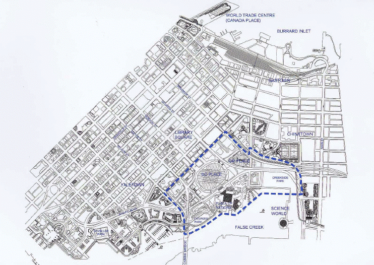
The endorsement of a plan for Northeast False Creek (NEFC) (see Figure 1) is recommended. Planning for the area is being undertaken in phases. Council is being presented with an Urban Design Plan which identifies an overall structure for access, movement, and land use in the area. The general recommendations of the Urban Design Plan are presented and discussed in this report. Staff seek Council approval for Phase One recommendations (see Appendix A), which will result in amendments to the False Creek North Official Development Plan (FCNODP).
Phase One recommendations are identified throughout the report and also in italicized text in Appendix A . Recommendations include urban design parameters and a form of development for
Figure 1: Site Context and ODP Boundary
a new commercial precinct immediately west of BC Place Stadium. Work on this plan has been through a public-private partnership with Concord Pacific, the Plaza of Nations, PavCo and PCI Developments each contributing $10,000 to pay for a portion of the City's cost to staff and resource this study.
Technical work has been undertaken by City staff and James Cheng Architects, Ward Consulting, PBK Architects and Civitas Urban Design and Planning, working on behalf of the stakeholders.
This planning initiative responds to the inhospitable pedestrian environment, weak pedestrian connections to the waterfront, terrain challenges such as a 14 metre (45 ft.) escarpment, and the lack of human scale created by the roadway network and the two sports stadiums. It also accommodates changing land use needs since the time of originally fixing the FCNODP.
The plan has the following components:
· improve the pedestrian environment, access and connections by:
-extending Smithe Street from Expo Blvd. to Pacific Blvd. with a visual extension to False Creek,
-improving the concourses that wrap around BC Place Stadium,
-creating a new connection from Georgia Street to Pacific Blvd,
-widening sidewalks and providing pedestrian bulges,
-providing improvements to Terry Fox Plaza,
-introducing new traffic signals to improve pedestrian access to the water, and
-providing retail and other storefront uses at-grade on key pedestrian routes;
· improve cycling and transit facilities by providing cycling lanes on Pacific Blvd. and Expo Blvd., securing a right-of-way for a future rapid transit line including the integration of a rapid transit station beneath Smithe Street between Expo and Pacific Blvds. and a right-of-way on Pacific Blvd. for the tram;
· secure water views down Georgia Street to Science World and Abbott Street to False Creek and create a new water view down Smithe Street;
· create a publicly accessible plaza within a new commercial precinct, with character inspired by elements of Old Yaletown. This precinct will provide a gateway to the downtown at the foot of the Cambie Bridge (Smithe Street off-
ramp) bordered by office buildings with retail, restaurants, and service uses at-grade;
· reallocate densities and land uses between sites owned by Concord Pacific Group Inc. (CPGI) in NEFC, while maintaining the same total overall development allowance and the balance between residential and non-residential floor space in the existing FCNODP, except as noted below;
· create up to 49 330 m2 (531,000 sq. ft.) of new non-residential floor space in Phase One to accommodate office space, a conference centre, retail and other uses at-grade, storage areas for BC Place Stadium and allow for additions to the Stadium which will give a face more in keeping with other buildings in the central area.
It is also recommended that Council take the first step in implementing the Northeast False Creek Urban Design Plan by instructing the Director of Current Planning to make application to amend the FCNODP and by referring the amendments (attached as Appendix B) to public hearing (refer to Figure 2 for an illustration of the amendments):
-the transfer of 27 870 m2 (300,000 sq. ft.) of permitted commercial floor space from area 7B (the Viaducts site) to area 5B (the Cambie Bridgehead site);
-the creation of 49 330 m2 (531,000 sq. ft.) for area 10 (BC Place Stadium) to accommodate a conference centre, office space, interior storage space for Stadium functions (e.g. seating that is currently stored outside the building) and retail and restaurant uses at-grade;
-the designation of the following two blocks as mixed residential and non-residential use (i.e. `Choice of Use'): the block bounded by Expo Blvd., Beatty Street, Nelson Street and Smithe Street (currently identified as commercial) and Area 7B (currently identified as commercial); and
-the extension of Smithe Street from Expo Blvd. to Pacific Blvd.
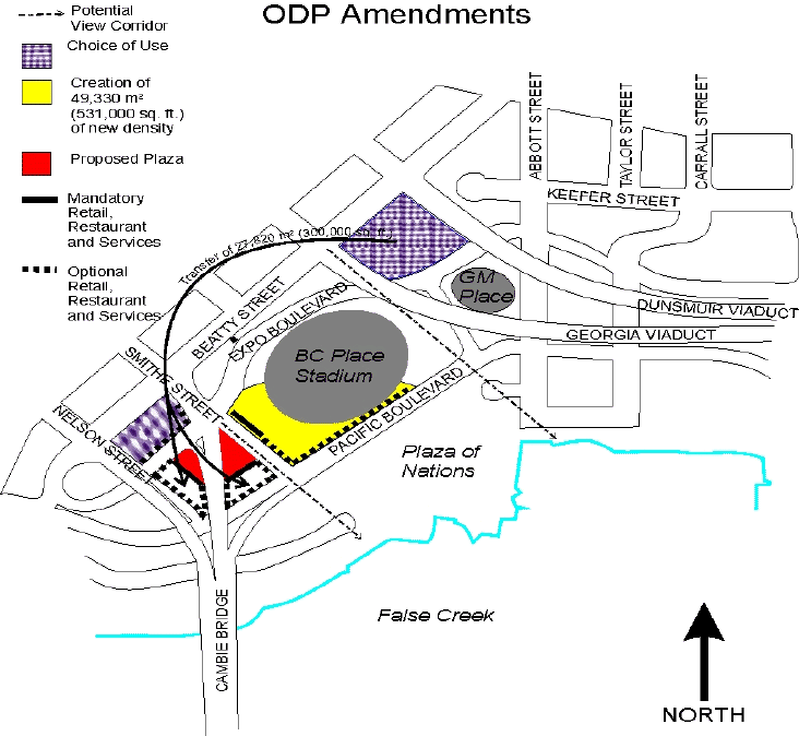
Figure 2: FCNODP Amendments - Phase One
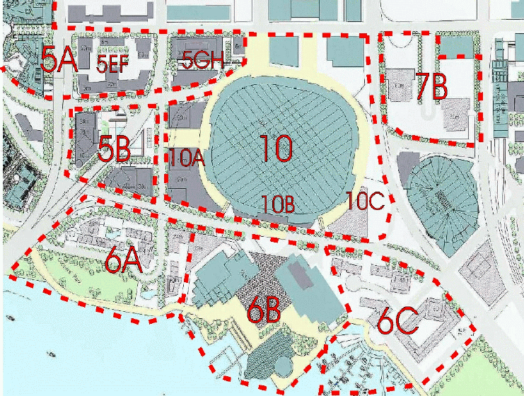
Figure 3: FCNODP Areas
With the exception of the additional floor space proposed for Area 10 (Stadium site), the amendments will leave intact the totals for the number of residential units and the amount of permitted residential and non-residential floor area under the present FCNODP.
BACKGROUND
City staff, working in conjunction with the property owners in Northeast False Creek, have prepared an Urban Design Plan for Northeast False Creek. The property owners involved with the preparation of the Plan have included Concord Pacific, PavCo (the Crown Corporation responsible for BC Place Stadium, the Vancouver Convention & Exhibition Centre and other facilities), Orca Bay, Canadian Metropolitan Properties (Plaza of Nations) and Central Heat Distribution Limited.
Northeast False Creek (see site context map - Figure 1) contains 40.2 hectares (99.33 acres) and includes 1.13 km (0.7 miles) of waterfront. The area includes 6.8 hectares (16.8 acres) of park space of which 1.53 (3.8 acres) hectares have been developed (Coopers Park) and 5.3 hectares (13.1 acres) of park space (Creekside Park) remain to be developed. The FCNODP
identifies a zoned development potential of 311 000 m2 (3,350,000 sq. ft.) of floor space (excluding BC Place Stadium) for the study area.
Planning for future development of the site is being approached in two phases:
Phase One: - the identification of issues, objectives and policy directions for the area;
- detailed work on a proposed form of development for the Cambie Bridgehead, a proposed new commercial precinct west of BC Place Stadium; and
- the preparation and Council's consideration of Official Development Plan amendments (attached as Appendix B).
Phase Two: - detailed urban design planning for the waterfront areas (located between the Cambie Bridge and Abbott Street), the viaduct sites (between the Dunsmuir and Georgia Viaducts, east of Beatty Street) and a proposed development site on PavCo lands at the southeast corner of BC Place Stadium, which may include allocation of additional density;
- the consideration and review of rezoning applications for areas to be initiated by the property owners (including the Cambie Bridgehead sites and the proposed site for Costco).
DISCUSSION
Key Issues
In planning for Northeast False Creek the following key issues were considered:
· pedestrian connections between the downtown and False Creek are inadequate;
· pedestrian, cycling and transit facilities are inadequate within the area;
· the current form of development approved for the area will cut off a view to the water (False Creek) from areas downtown (i.e. Smithe Street);
· the scale and form of buildings and the configuration and design of roadways is inhospitable for pedestrians as compared to other areas of the downtown; and
· there is a demand for more office space closer to `Old Yaletown' because businesses are seeking space in lower scale buildings with larger floor plates not typically found in the central business district.
Objectives (in bold)
The following objectives for the Northeast False Creek Urban Design Plan are recommended:
· Improve pedestrian, cycling and transit connections between areas of Northeast False Creek and with adjacent neighbourhoods, with particular emphasis on improving access to the False Creek waterfront, and the Cambie Bridge, (including wider sidewalks, improved pedestrian crossings, a right-of-way for a streetcar on Pacific Blvd. and rights-of-way for below grade rapid transit through the area).
Better integration of Northeast False Creek with the downtown peninsula can be achieved by the introduction of new and improved pedestrian connections from Smithe, Robson and Georgia Streets, and improvements to the exterior Stadium concourses, as detailed in the discussion on the creation of additional density on the PavCo site.
It is proposed that there be dedicated cycling lanes on Expo Blvd. and Pacific Blvd., an improved connection from Smithe Street at Expo Blvd. to the wide easterly Cambie sidewalk, as well as the opportunity to use the concourses as a cycling route.
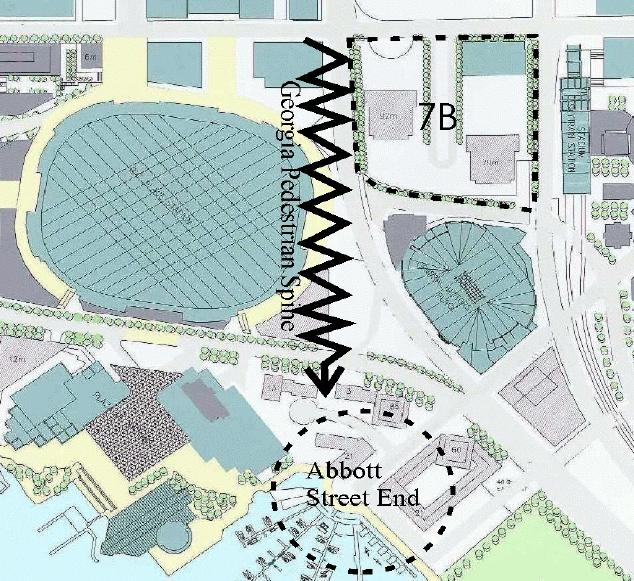
It is also suggested that in Phase Two, planning for a spine of development on the east side of BC Place Stadium be pursued. This would reinforce a pedestrian linkage between Georgia Street and the False Creek waterfront at the foot of Abbott Street.
The following pedestrian, cycling and transit facilities are envisaged to implement the plan:
Expo Blvd: It is proposed that Expo Blvd. will remain a one-way street. The plan envisages the deletion of one moving lane of traffic and its replacement with a sidewalk on the north side of Expo Blvd., the widening of the sidewalk on the south side as well as a bicycle lane. Options for staging on Expo Blvd. will be explored further. Analysis indicates that the two lanes can handle the projected traffic during off-peak periods;
Pacific Blvd: Replacing the elevated pedestrian structures with a traffic signal is recommended. This will facilitate pedestrian flow to the new entrance (for the Stadium's trade and consumer shows) proposed at a location at grade across from Plaza of Nations.
Significant review work has been done on the ultimate configuration of both Pacific Blvd. and Expo Blvd. through the Northeast False Creek Planning Study. This work has identified that it would not be possible to accommodate two way traffic on Expo Blvd. as well as a bike lane and wider sidewalks. Furthermore, it would be challenging and not necessarily desirable to accommodate two way traffic on Pacific Blvd. with bike lanes, wider sidewalks and a streetcar right-of-way. However, the latter has not yet been ruled out. Further work on the design of Pacific Blvd. will becarried out in the next phase and will be reported back to Council in a separate report. It is proposed that there will be a bike lane and wide sidewalks on both sides of the street. A right-of-way for a streetcar on Pacific Blvd. has been secured on the south side of the street as part of a previous rezoning. This connection will be explored in greater detail in Phase Two of the planning process.
Connections to the Stadium Skytrain station: A new connection between the corner of Georgia and Beatty Streets and Pacific Blvd. via the easterly Stadium concourse will improve access to rapid transit and to the waterfront from downtown.
Rapid Transit: The possibility of relocating a rapid transit station under Smithe Street, near Pacific Blvd. One potential Vancouver-Richmond rapid transit route could be via a tunnel near Smithe Street, thus creating the opportunity for a station in the vicinity of the Bridgehead commercial precinct and the Stadium.
· Extend Smithe Street from Expo Blvd. to Pacific Blvd. and investigate its extension south of Pacific Blvd.
As noted above, a key initiative of the urban design plan is to extend Smithe Street south of Expo Blvd. to improve pedestrian connections and provide a street end view of the water. Furthermore, study is required to determine the feasibility and cost implications of creating an intersection at Pacific Blvd. and Smithe Street, with Smithe Street extending closer to the water.
· Improve and preserve street-end views
The plan identifies two new potential street end views to the False Creek waterfront, at the terminus of Smithe Street and Georgia Street. Phase Two of planning will confirm these street end views. Modifications will have to be made to the proposed form of development for the future waterfront neighbourhood immediately east and west of the Plaza of Nations. The extension of Smithe Street from Expo Blvd. to Pacific Blvd. is particularly important in ensuring the creation of this view. The Abbott and Robson street views will continue to be protected.
· Improve the pedestrian environment by providing street-oriented retail, where possible, and pedestrian interest (landscaping, street furniture and other amenities) along all streets.
A particular focus of the plan is to improve the currently inhospitable environment for pedestrians. The plan establishes a pattern of streets and open spaces linked to the pattern of downtown streets. The provision of landscaping and other amenities is also recommended.
It is also recommended that retail, restaurant and similar `storefront' businesses be permitted on most streets west of the Stadium in the Cambie Bridgehead area. The recommended ODP amendments include provisions permitting retail which are permissive for almost all street frontages allowing the developer or building owner to judge the viability of retail. The amendments only make it mandatory to provide retail on the key frontages facing the proposed Bridgehead plaza to assist in animating this new public space. As part of the CD-1 rezonings for the Bridgehead precinct, staff are recommending a retail review be undertaken (see Appendix A, page one of four, Policy Direction # 1) that shall study the viability of retail fronting the plaza and on street locations and consider the impacts of additional retail on other commercial areas. The possibility of interim uses, if necessary, pending the emergence of a market for retail and similar businesses will also be explored. At this time, as a matter of public policy, staff recommend that the plaza frontages be identified as a priority for retail and similar uses.
As part of Phase Two, staff will work with PavCo and others on the preparation of a plan for a spine of development which reinforces pedestrian linkages and amenities between Georgia Street and the False Creek waterfront at the foot of Abbott Street, on the east side of BC Place Stadium.
· Establish the Cambie Bridgehead as a gateway landmark entrance to the downtown.
A Bridgehead Plaza at the northern foot of the Cambie Bridge is proposed which will be a gateway to the downtown. The proposed form of development will provide an edge and definition for the Plaza (See Figure 5). Retail, restaurant and similar uses are proposed for the ground floor of these buildings to animate the plaza. Staff recommend that the landowner and the City work on a cooperative basis for the design of the plaza at the time of area rezoning.
· Ensure buildings in the Cambie Bridgehead area reflect some elements of Yaletown's character and provide a transition from Yaletown to waterfront residential.
It is proposed that the buildings around the Cambie Bridgehead Plaza at the foot of the Cambie Bridge incorporate design details, materials and large canopies similar to those found in the Yaletown warehouse district. The possibility of extending the "docks" configuration into the area will also be explored.
Figure 4 : Illustrative Plan
LEGEND
Movement and Connections
1. Improve pedestrian, cycling, and transit connections and facilities.
2. Extend Smithe Street from Expo Blvd. to Pacific Blvd. and investigate its extension south of Pacific Blvd.
Land Use and Urban Design
3. Improve and preserve street-end views.
4. Improve the pedestrian environment.
5. Establish a gateway landmark entrance to the downtown.
6. Ensure buildings reflect some elements of `Old Yaletown' character and provide a transition from Yaletown to waterfront residential.
7. Improve Terry Fox Plaza.
8. Provide a new activity node.
9. Reallocate densities and land uses between sites.
10. Create of new density for the BC Place Stadium site.
Figure 5:Cambie Bridgehead Site Plan
· Improve Terry Fox Plaza and reinforce its importance as the termination of Robson Street.
A new two story building, with retail and restaurant uses is proposed in the vicinity of the BC Place Gap site, adjacent to the western edge of the Terry Fox Plaza as part of the development of the proposed commercial building at 858 Beatty Street. This was agreed to at a Public Hearing on June 28, 2001. It will serve to improve the definition and animation of the plaza. PavCo proposes to relocate Terry Fox memorial so that it lines up with the centre line of Robson Street.
· Provide a new activity node where Abbott Street meets False Creek.
The plan proposes that the waterfront neighbourhood immediately east of the Plaza of Nations include a mix of uses which will result in this being a waterfront destination which could include cafes, restaurants and retail uses, as well as types and forms of housing which are compatible with mixed use. For example, there is an opportunity to create here a maritime village centre with live/work housing and `high-tech' offices integrated with other commercial uses and housing fronting on the water.
· Reallocate densities and land uses between sites in Northeast False Creek, while maintaining the total overall densities and balance between residential and non-residential densities (except as noted below for BC Place Stadium).
A new land use plan is recommended for this area (see figures 6 and 7 for current and proposed land use plans) and can be implemented through the attached ODP amendments. The recommended ODP amendments in this report suggest the transfer of 27 870 m2 (300,000 sq. ft.) of commercial floor space from area 7B (the Viaducts site) to the Cambie Bridgehead (area 5B west of the Stadium).
Council has approved an initial "swap" of residential and non-residential floor space as part of the rezoning of the 800 block of Beatty Street in order to accommodate the proposed Pivotal Software head offices. As a result, a new land use pattern, in which non-residential is mixed with residential development, will become prevalent on sites around BC Place Stadium. Two exceptions will be the Cambie Bridgehead site (which will be primarily non-residential) and the waterfront neighbourhood immediately east of the Cambie Bridge (which will be primarily residential).
The reallocation of floor space for these sites maintain the same total floor space and the same overall totals for residential and non-residential floor area (except as noted below for BC Place Stadium site Phase One).
Land use adjustments to zoning in this area will ensure that the total number of non-market units for areas 5, 6 and 7 (of which 50% must be designated for families with children) will
be maintained, should any sites be moved within and between the areas. This review will be undertaken as part of Phase Two of planning for this site. The ODP amendments recommended in this report do not affect the present numbers and locations of non-market housing units.
Figure 6: Currently Approved Land-Use
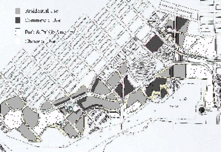
Figure 7: Proposed Land Uses
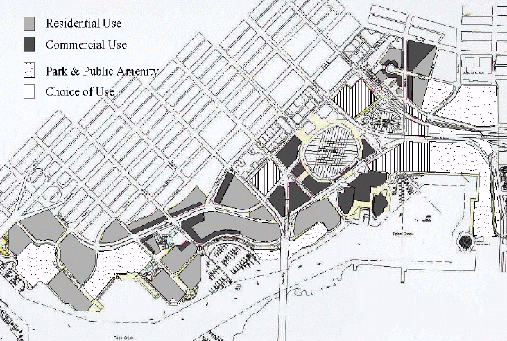 The FCNODP identifies `choice of use' areas as mixed use: commercial/residential in the ODP land use map. For Northeast False Creek, `choice of use' means that the currently permitted residential and non-residential development potential can be interwoven within a neighbourhood where residential livability is not challenged. Development will not be able to exceed the limits on residential and non-residential floor space currently set by the FCN ODP. This plan recommends that `choice of use' be the designation for area 5EF (bounded by Smithe Street, Expo Blvd., Nelson Street, Beatty Street), area 6C (immediately east of the Plaza of Nations, on the False Creek waterfront extending to Abbott Street), and area 7B (between the viaducts, east of Beatty Street to Expo Blvd.) (See Figure 7). `Choice of use' zoning between residential and non-residential land uses has been successfully implemented in the downtown for areas adjacent to the Central Business District. The recommended ODP amendments adjust the land use map in the ODP to reflect `choice of use' for area 5EF and area 7B. This will only work in area 7B if we can create a fully integrated self-contained residential neighbourhood - this will be tested in Phase Two of planning. ODP amendments regarding the designation of area 6C as a mixed use neighbourhood will be done in later phases of work.
· Create new density for the BC Place Stadium Site (Area 10) to achieve urban design objectives and to improve the public realm.
Staff are recommending that Council consider creating up to 49 330 m2 (531,000 sq. ft.) of new floor space on lands to the west and the south of the Stadium. Council has approved a series of land trades to accommodate the extension of Smithe Street south from Expo Blvd. to Pacific Blvd.. This initiative will allow for two strategic development sites on which PavCo's two office buildings and conference centre could be built. This conference centre would replace the Robson Conference Centre, and would be built on the corner of Smithe Street and Pacific Blvd.
Staff support creating up to 49 330 m2 (531,000 sq. ft.) of new non-residential floor space, as this would address the following urban design considerations and pedestrian environment improvements:
· Urban Design Considerations:
-the buildings on the western edge of the Stadium will provide a building face for Smithe Street and Pacific Blvd., and a scale and form of buildings more typical of a Vancouver street, thus screening the massive forms of the stadium; and
-the buildings will assist in defining the new Cambie Bridgehead Plaza;
· Pedestrian Environment Improvements:
-increased floor space would allow for additions to BC Place Stadium which would then provide retail and other storefront uses adjacent to the sidewalk on the extension of Smithe Street and on the north side of Pacific Blvd;
-this would be accompanied by:
-improvements to the Stadium's western exterior pedestrian concourse making it barrier-free for the disabled;
-the replacement of elevated pedestrian Pacific Blvd. crossings with a new grade-level crossing of Pacific Blvd., and a traffic signal; and
-an agreement in principle to allow for a link from Georgia Street to the pedestrian concourses and down to Pacific Blvd., to be pursued as part of the next phase of planning (questions regarding its design and the financial responsibility for this facility will be determined as part of planning areas to the east of the Stadium).
Staff also considered the longstanding Central Area Plan policy which does not support the creation of additional commercial development potential and favours housing in the central area. This policy was based on the concern that transportation and other infrastructure did not have the capacity to support additions to the total of commercial development allowances in the central area. On balance, staff do support the additional commercial development allowance in this particular case noting that:
-approximately 20% of the floor space would be for a conference centre which would support downtown business;
-commercial is a preferable use in this location because the livability of housing could be compromised by its location immediately adjacent to the stadium;
-it will allow for the interior storage of the remove able beachers that are currently stored outside the stadium; and
-the impact on roadway infrastructure would be modest with rapid transit located nearby, and -accessibility to the area by pedestrians, cyclists and transit would be improved.
Also, the appropriate ultimate development pattern for the Stadium was not focussed on in the initial planning of False Creek North more than 10 years ago and in the drafting of the original ODP. This was because attention zeroed in on locations with major development potential, especially for housing, and because it was thought no further development on the Stadium site would be contemplated by the Provincial government. An urban design analysis accompanying CD-1 rezonings of the Stadium site will determine whether the full density, as identified in the amended FCNODP, can be achieved.
The amenities and infrastructure requirements and agreements for Area 10 BC Place Stadium), as identified in Appendix C are acceptable to staff, however the list is not comprehensive. The list should be endorsed for guidance in further detailing the amenities and infrastructure requirements which will be associated with CD-1 rezonings in area 10 (BC Place Stadium site).
Proposed False Creek North Official Development Plan Amendments
A number of initial amendments to the FCNODP (attached as Appendix B) are recommended to reflect the following aspects of the Northeast False Creek Urban Design Plan (Figure 2):
-the transfer of 27 870 m2 (300,000 sq. ft.) of permitted commercial floor space from area 7B (the Viaducts site) to area 5B (the Cambie Bridgehead site);
-the creation of up to 49 330 m2 (531,000 sq. ft.) for area 10 (BC Place Stadium) in Phase One to accommodate a conference centre, office space, retail and restaurant uses at grade;
-the designation of the following two blocks as mixed residential and non-residential use (i.e. `Choice of Use'): the block bounded by Expo Blvd., Beatty Street, Nelson Street and Smithe Street and area 7B (the Viaducts site); and
-the extension of Smithe Street from Expo Blvd. to Pacific Blvd.
Further amendments may be proposed following subsequent phases.
Phase Two of Planning
Planning during Phase Two will implement the conclusions of Phase One (especially with zoning) and focus on those areas south and east of BC Place Stadium. Guided by the overall policies on land use, urban design, and movement established in phase one, the following work is envisaged:
1) Movement:
-consider options for the design of Pacific Blvd (in the context of the Downtown Transportation Plan);
-consider whether Beatty Street should become a two way street (in the context of the Downtown Transportation Plan); and
-pursue the design of a new barrier-free pedestrian connection between Georgia Street, the eastern Stadium concourse and Pacific Blvd.
1) Implementing Conclusions of Phase One - New Neighbourhoods:
-consider rezoning applications for area 5B (Cambie Bridgehead) and area 10 (BC Place Stadium).
-initiate detailed planning for area 6A (south of Pacific Blvd. between the Cambie Bridge and the Plaza of Nations) including possible changes to the form of development to open up a street end view down Smithe Street to the water, and minimize impacts from the Plaza of Nations on housing; review whether additional density can be transferred to this area from elsewhere in Northeast False Creek and the possibility of a new intersection at Smithe Street and Pacific Blvd.
2) Plan New Neighbourhoods:
-pursue the planning of three coherent but interconnected areas to tame the three dimensionally difficult situation due to the presence of an escarpment and viaduct structure in the area adjacent to BC Place Stadium and GM Place Stadium by:
-initiating detailed planning for area 7B (the viaducts area), including the consideration of a forthcoming rezoning for a Costco store fronting on Expo Blvd.;
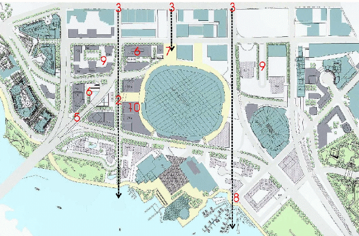
-pursuing the design of a "Pedestrian Spine" (see Figure 8) with retail, other uses and amenities including the consideration of additional development potential at the southeastern corner of the Stadium (Area 10 Phase Two) adjacent to Pacific Boulevard and Griffith's Way; and
-initiating detailed planning for area 6C (Abbott St. end neighbourhood, east of Plaza of Nations) creating a maritime village centre and mixed-use precinct; and
-ensure there are satisfactory sites for non-market housing in cases where a site has been replaced by non-residential or other development;
-initiate detailed planning for area 6B (Plaza of Nations).
Economic and Social Development
-seek out opportunities, where practical given the types of development and businesses contemplated for an area, for training and job creation which benefit the east downtown residents. This will require further discussion as it came up during the public review and practical opportunities will need to be identified in consultation with property owners, area businesses, developers and the adjacent east downtown community.
Figure 8 - Phase Two Planning
Public Review Comments
Staff conducted two Open Houses which were attended by about 150 people. Presentations were also given to the Chinatown Revitalization Committee, Vancouver Board of Trade, Downtown Vancouver Association, and the Bicycle Advisory Committee. Input received at these meetings favourably endorsed the Urban Design Plan with a majority endorsing the proposed changes in land uses and permitted densities, the proposed commercial precinct, the extension of Smithe Street and the improved pedestrian, bicycle and transit facilities. (See Appendix E for a summary of the responses to a comment sheet and all written comments received)
There were some concerns raised by some groups and individuals. The Board of Trade and some individuals expressed concern with the reduction of parking around the Stadium and the increase in traffic signals because, in their view, it will slow traffic.
Community Directions, a group active in the east downtown, requested that future planning seek out economic and social development opportunities for the local population through the provision of training and jobs.
In particular, the Board of Trade and the Downtown Vancouver Association endorsed the proposed increases in commercial floor space on the PavCo lands.
The Urban Design Panel was unanimous in its endorsement of the proposed plan.
CONCLUSION
The Northeast False Creek Urban Design Plan has been prepared in a co-operative planning process involving City staff and the property owners and their respective design teams. It provides the opportunity to guide positive change in an area that is largely undeveloped. Among its objectives are the creation of a new commercial precinct providing a distinctive gateway to the downtown and a new publicly accessible open space, creation of an activity spine between the two stadiums from Georgia Street to a focussed maritime village centre on False Creek, possibly the creation of a new mixed-use neighbourhood between the viaducts, significant improvements in pedestrian and bicycle amenities, and the provision of human scale in a corner of the central area which is dominated by large physical structures, vast parking lots, difficult pedestrian crossings and a valuable waterfront cut off from the downtown by congested roadways.
* * * * *
Appendix A
Page 1 of 5
OBJECTIVES AND POLICY DIRECTIONS
NORTHEAST FALSE CREEK URBAN DESIGN PLAN
Objectives are in bold.
Policy Directions that are recommended for implementation at this time are in italics.
· Improve pedestrian, cycling and transit connections between areas of Northeast False Creek and with adjacent neighbourhoods, with particular emphasis on improving access to the False Creek waterfront, and the Cambie Bridge, (including wider sidewalks, improved pedestrian crossings, a right-of-way for a streetcar on Pacific Blvd. and rights-of-way for rapid transit through the area) in conjunction with the Downtown Transportation Plan.
10. Amend the FCNODP to require at key locations and permit and in other locations allow for retail and similar uses at grade, with the proviso that as part of the rezoning process there shall be a study of the viability and impact on other retail areas.
2. Facilitate improved pedestrian and cycling connections from Smithe, Robson and Georgia Streets to the waterfront through improvements to the exterior concourses, traffic signals and the review of the feasibility of extending Smithe Street from Expo Blvd. to near the False Creek waterfront.
3. Create dedicated cycling lanes on Expo Blvd. and Pacific Blvd, an improved connection for cyclists from Smithe Street at Expo Blvd. to the wide easterly Cambie sidewalk as well as the opportunity to use the stadium concourses as a cycling route.
4. Pacific Blvd: provide a single bike lane and wide sidewalks on each side of the street, corner bulges, and a right-of-way for a streetcar on Pacific Blvd. that was secured on part of the south side of the Pacific Blvd. as part of a previous rezoning.
5. Expo Blvd: provide a wider southerly sidewalk and a new northerly sidewalk as well as a cycling lane by the deletion of one moving lane.
6. Investigate options for staging of trucks on Expo Blvd.
Appendix A
Page 2 of 5
7. Remove the elevated pedestrian structures over Pacific Blvd. and replace them with a traffic signal and an improved crosswalk with special surface treatment in front of the new entrance for the Stadium trade and consumer show entrance across from the Plaza of Nations.
8. Improve the westerly Stadium concourse so that it is barrier free and design it so that it terminates at-grade at Pacific Blvd.
9. Improve connections to the Stadium Skytrain station by improving the easterly Stadium concourse providing for a new connection between the corner of Georgia and Beatty Streets and Pacific Boulevard via the easterly Stadium concourse and ensure that it is barrier free, wherever possible.
10. Explore the relocation of a below grade rapid transit line and station under Smithe Street, near Pacific Boulevard creating the opportunity for a station in the vicinity of the Bridgehead commercial precinct and the Stadium.
· Extend Smithe Street from Expo Blvd. to Pacific Blvd. and investigate its extension south of Pacific Blvd.
1. Investigate the creation of a new intersection at Smithe Street and Pacific Blvd. to facilitate pedestrian crossings.
2. Investigate the potential of extending Smithe Street south of Pacific Boulevard to provide a new second entrance to area 6A, and create a street end view to False Creek.
· Improve and preserve street-end views.
1. Investigate the creation of two new street end views to the waters of False Creek at the terminus of Smithe Street and Georgia Street, including examining potential modifications to proposed forms of development for areas 6A, 6C and 10.
2. Ensure that the Abbott street-end view is protected when area 6C is rezoned and that the Robson street view is protected.
Appendix A
Page 3 of 5
· Establish the Cambie Bridgehead as a gateway landmark entrance to the downtown.
1. Create a Bridgehead plaza at the northern foot of the Cambie Bridge which will be a gateway to the downtown.
2. Amend the FCNODP to require retail, restaurant and similar uses for the ground floor of these buildings to animate the plaza.
3. Rezonings for this precinct should be accompanied by a study of the viability of retail and similar uses in the precinct to ensure a successful mix of business and to minimize impacts on adjacent commercial districts and to explore the potential for interim uses until the neighbourhood develops.
4. Establish a cooperative work process between the landowner and the City for the design of the Bridgehead Plaza, as part of the CD-1 rezonings in the Bridgehead precinct.
· Ensure buildings in the Bridgehead Sector reflect some elements of Yaletown's character and provide a transition from Yaletown to waterfront residential.
1. Buildings in the Bridgehead Plaza at the foot of the Cambie Bridge should incorporate design details, materials and large canopies similar to those found in the Yaletown warehouse district.
· Improve Terry Fox Plaza and reinforce its importance as the termination of Robson Street.
1. Permit the development of a new two story building, with retail and restaurant uses on the BC Place Gap site, immediately to the west of the Terry Fox Plaza to improve the definition and animation of the plaza. (Has been approved by Council as part of the rezoning of `the gap' site)
2. Endorse the proposal by PavCo to relocate the Terry Fox memorial so that it lines up with the centre line of Robson Street.
Appendix A
Page 4 of 5
· Provide a new activity node where Abbott Street meets False Creek.
1. When area 6C, immediately west of the Plaza of Nations, is rezoned, consider a mix of uses resulting in this being a waterfront destination that could include cafes, restaurants and retail uses, as well as types and forms of housing which are compatible with mixed use.
· Reallocate densities and land uses between subareas in Northeast False Creek, while maintaining the total overall densities and the balance between residential and non-residential densities (except as noted below for BC Place Stadium).
1. Adopt a new land use plan and implement it through amendments to the FCNODP
2. Transfer 27 870 m2 (300,000 sq. ft.) of commercial floor space from area 7B (the Viaducts subarea) to the area 5B Cambie Bridgehead west of the stadium.
3. Allow for `choice of use' by allowing for the`Swap' of permitted residential and non-residential densities on site 5EF and area 7B by allowing the transfer of up to 37,160 m2 (400,000 sq. ft) of permitted residential floor space from site 5EF to area 7B and 41,805 m2 (450,000 sq. ft.) of non-residential floor space from area 7B to site 5EF.
4. Consider the transfer of permitted residential floor space 4645 (50,000 sq. ft.) from site 5EF to area 6A, following an urban design analysis of alternative forms of development on area 6A.
5. Allow for `choice of use' in area 6C by considering the transfer of permitted non-residential floor space from area 7B to area 6C, following an urban design analysis of alternative forms of development and uses on area 6C.
· Creation of new density for the BC Place Stadium Site (Subarea 10 Phase One) to achieve City urban design objectives and for public realm improvements.
1. Amend the FCNODP to create up to 49,330 m2 (531,000 sq. ft.) of new floor space on lands to the west and the south of the stadium to accommodate a conference centre, retail and similar uses at-grade, ancillary stadium uses such as storage, office space, and expanded event space for BC Place Stadium, noting that the density achieved through CD-1 rezonings will be subject to urban design review.
Appendix A
Page 5 of 5
2. Endorse the offer of a public amenity and infrastructure package by PavCo to be associated and implemented in conjunction with the CD-1 rezonings permitting increased non-residential floor space on area 10 Phase One (Stadium site).
3. Consider the creation of additional development potential at the southeastern corner of the Stadium (Area 10 Phase Two) adjacent to Pacific Boulevard and Griffith's Way.
Appendix B
Page 1 of 9
SUMMARY OF CHANGES TO FCNODP TEXT AND FIGURES
SUMMARY OF CHANGES TO FCNODP TEXT
Section 3.2.2. Office
· Allow high-rise and medium-density office uses in the Cambie Bridgehead area (instead of only low to mid-rise and low-density).
· Increase maximum total permitted office densities and street or pedestrian-oriented retail and service uses (in office areas) from 156,785 sq. m (1,687,675 sq. ft.) to 187,300 sq. m.(2,016,146 sq. ft.).1
· Add a maximum of 18,815 sq. m (202,530 sq. ft.) of non-residential floor area for conference centre (including meeting rooms, banquet areas, kitchens, lobby areas, ancillary offices and retail and service uses) and expanded Stadium event space area in sub-area 10. 2
Section 3.2.4. Retail and Service
· Require new mandatory at-grade retail and service uses in sub-area 5(b), and 10 where possible.
Section 5 Sub-areas
5.5 Areas 5(a) & 5(b)
· Define sub-area 5(b) for office uses.
· Require a pedestrian system to link 5(a) and (b) with other sub-areas.
· Require a major publicly accessible plaza at the foot of the Cambie bridge ramp in the vicinity of Smithe Street and Expo Blvd.
· Note that special attention should be paid at the sub-area zoning stage to the siting of the buildings next to the Cambie Bridge to create a gateway to the downtown.
Appendix B
Page 2 of 9
· Allow for medium-density and high-rise buildings.
· Require mandatory retail and service uses on the west and south edge of the proposed Bridgehead Plaza at the base of the proposed towers.
5.6 Area 6(a)
· Note that attention should be paid at the sub-area zoning stage to creating a new second access to the development parcel from the intersection at Smithe Street and Pacific Blvd., thereby extending the view down Smithe Street to the water.
5.10 Area 7(b)
Define sub-area 7(b) for Mixed-Use: Commercial/Residential.
5.13 Area 10 (BC Place Stadium)
· Allow office, conference centre (see: description above), at-grade retail and service in areas to the west and south of the Stadium.
· Note that in office sub-area on west side of the Stadium, building massing and siting should define an edge for the Bridgehead plaza (sub-area 5(b)), including mandatory retail or service uses, where feasible.
· Note street-oriented retail and service uses at grade will be encouraged along Smithe Street and Pacific Blvd. to create a pedestrian-friendly street facade.
· Note the conference centre is to be located in the vicinity of Smithe Street and Pacific Blvd.
· Note that the Stadium concourses are to be improved to provide barrier-free access to the surrounding streets (Beatty Street, Smithe Street, Robson Street, and Pacific Blvd.).
SUMMARY OF CHANGES TO FCNODP FIGURES
Figure 1 ODP Boundary to be amended to show the new road network - the extension of Smithe St. to Pacific Blvd.
Figure 2 Shoreline: Permitted Cut & Fill to be amended to show the new road network, as noted above.
Figure 3 Land Use to be amended to show the new road network and be amended to change the use allowed for the north block of sub-area 5(a) (bounded by Expo Blvd., Beatty Street, Nelson Street and Smithe Street) and 7(b) (bounded by Expo Blvd., Beatty Street, Georgia Street, and Dunsmuir Street) to Mixed Use: Commercial/Residential use
Appendix B
Page 3 of 9
The western and southern edge of BC Place Stadium to be shown as office use (including retail and service uses), conference centre, and expanded stadium-related uses. Further, new required at-grade retail and service uses are shown on three edges of the Bridgehead Plaza 5(b) at the base of the two office towers in sub-area 5(b) and on the western edge of BC Place Stadium on sub-area 10 along Smithe Street.
Figure 4 Residential Units to be amended to show new road network.
Figure 5 Office Development to be amended to show new road network and new office
areas on west side of BC Place Stadium to show a maximum office floor area of 30,515 sq. metres (328,472 sq. ft) in sub-area 10 (not including conference centre and Stadium
ancillary uses); to show sub-area 5(b) with a maximum office floor area of 46,450 sq m.(500,00 sq. ft); and to reduce the maximum office floor area on Area 7(b) from 87,668 sq. m (943,681 sq. ft) to 59,798 sq. m (643,681sq. ft). Also to show new optional and mandatory retail and service uses, as described for Figure 3.
Figure 6 Parks to be amended to show the new road network.
Figure 7 Phasing of parks and community facilities to be amended to show the new road network.
Figure 8 Marinas to be amended to show the new road network.
Figure 9 a Movement to be amended to show the new road network, as described above.
Figure 9 b Movement to be amended to show new road network and updated pedestrian pathways in the northeast False Creek area and removal of elevated pathways in the Cambie Bridgehead area.
Figure 9 c Movement to be amended to show new road network base and updated bike paths/routes.
Figure 10A Views to be amended to show new road network.
Figure 10B Views to be amended to show new road network and highlight potential street view corridors along Smithe Street and Georgia Street..
Figure 11 Sub-areas to be amended to show the new road network.
Appendix B
Page 4 of 9
Figure 12 a Illustrative Plan to be amended to show the new road network.
Figure 12 b Non-market Housing Sites to be amended to show the new road network.
Figure 12 c Maximum Tower Heights to be amended to show the new road network and the addition of 4 new towers - 2 in sub-area 5(b), at a maximum of 23 floors for the west building and 14 floors for the east, and 2 on the western edge of the Stadium in sub-area 10, at a maximum of 16 floors for the north and 14 for the south. Note that office building floor limits have been calculated using 3.65 metres (12 ft.) floor to floor as a measure.
Appendix B
Page 5 of 9
DRAFT FALSE CREEK NORTH
OFFICIAL DEVELOPMENT PLAN AMENDMENTS
The False Creek North Official Development Plan shall be amended as generally outlined below. Note: all additions are in bold italics and deletions are in (brackets and strikeout).
3.2.2 Office
It is intended that offices be focussed to sites which meet the following criteria for office locations in the Central Area:
(a) enhance the success, livability, and attractiveness of the central business district -- access to waterfronts, views, and ease of face-to-face contacts;
(b) have good transit access;
(c) be a desirable office area;
(d) not be a threat to areas with a major stock of heritage buildings;
(e) not be an area with significant housing or with a high desirability for future housing; and
(f) not be an area where support services would be displaced without alternate locations.
These sites are located at the Cambie bridgehead and between the two viaducts. In addition, small-scale offices may be permitted in mixed-use and retail/service areas. Offices within the Cambie Bridgehead area are to be (low-rise to) mid-rise to high-rise and low-density to medium-density.
In office areas, cultural, recreational and institutional uses and limited retail and service uses may be permitted. Residential uses may also be permitted, subject to livability analysis at the sub-area zoning stage and included within the overall floor area and dwelling unit count limitations contained in Section 3.2.1.
Giving consideration to the densities permitted in nearby commercial areas, up to a maximum of (156,785) 187,300 square metres of office and street- or pedestrian-oriented retail and services uses may be permitted, generally distributed as shown on Figure 5. In addition, a maximum of 18,815 square metres of non-residential floor area will be permitted for a conference centre (including meeting rooms, banquet
Appendix B
Page 6 of 9
areas, kitchens, lobby areas, ancillary offices and retail and service uses) and expanded Stadium event space area in Sub-area 10 (see Figure 11). Offices existing
in the Stadium complex as of April 10,1990, and in the Plaza of Nations complex, are permitted but their area shall be excluded from the maximum amount of permitted office use.
3.2.4 Retail and Service
It is intended that retail uses be permitted to serve the needs of the projected population and provide specialized shopping opportunities. It is also intended that these uses link, reinforce, and extend, where appropriate, existing street-related retail patterns. Retail uses should not be of an amount or in locations which would unduly compete with or preclude the revitalization of retail areas established prior to April 10, 1990. In addition to retail and service uses, other uses, including residential entries, may be permitted at grade within retail/service areas, provided that they rely on walk-in trade or direct pedestrian access in the conduct of their operation and provide visual interest to passersby.
To accomplish the above intentions, the maximum amount of retail and service uses permitted outside of the areas designated as office on Figure 5 is 55 948 square metres. Of this total, the maximum amount of retail uses permitted is 36,420 square metres. Retail uses existing in the Stadium complex as of April 10, 1990, and in the Plaza of Nations complex, are permitted but their area shall be excluded from the maximum amount of permitted retail use.
Retail uses shall be required within Areas 4, 5(b), (and) 6(b) and 10 as shown on Figure 3 and Figure 11 and shall be located primarily at grade. Retail uses will be located where feasible, taking into account necessary entrances to buildings. Provision shall be made for a grocery store with a floor area of approximately 2,300 square metres at a location west of the Stadium. The remaining retail uses may be permitted generally as illustrated on Figure 3 and shall be located primarily at grade.
3.3 Movement
It is intended that a variety of means of moving through the area be provided, including streets, walkways, bicycle routes, transit and ferries. Bus routes shall be jointly determined by the City and (B.C. Transit) Translink, the regional transit authority, as
Appendix B
Page 7 of 9
ridership is generated by completed developments. [Note: the amendment in this paragraph is needed because of a change in name of the transit authority not previously noted]
These facilities shall be adequate to serve the needs of the population and integrated with the adjacent city, generally as illustrated on Figures 9A, 9B and 9C. Streets, walkways, and bicycle routes shall be designed, constructed, and conveyed, to the satisfaction of the City, by the owner prior to occupancy or use of the first building to be constructed in the area they are intended to serve. Agreements securing the design, construction, and conveyance of these facilities will be required prior to the enactment of sub-area zonings.
3.7 Building Orientation
Buildings with heights greater than 35 metres shall have the same orientation as the Downtown street grid; except in the Plaza of Nations complex where buildings may reflect the geometry of
the complex, and in the Quayside Neighbourhood where buildings may reflect the shoreline and the curve of the adjacent boulevard. The form of such buildings shall be pointed towers, not slabs. In the Cambie Bridgehead sub-area 5(b), the buildings may reflect the geometry of the Cambie bridge.
3.10 Public Realm Design Concepts
In addition to park designs and the normally required street designs, special public realm designs shall be prepared for the following areas concurrently with the related sub-area zonings:
(a) Keefer steps and circle;
(b) the waterfront drive west of Cambie Bridge;
(c) the crescent area at the southern foot of Richards Street;
(d) the waterfront walkway and seawall;
(e) (above-grade) pedestrian connections around the north end of the Cambie Bridge; and
(f) Pacific Boulevard, including a general overall concept with the first sub-area zoning adjacent to Pacific Boulevard.
Additional designs may be required as determined at the sub-area zoning stage.
Appendix B
Page 8 of 9
Section 5 Sub-areas
5.5 Areas 5(a) & 5(b)
These office and mixed-use areas comprise several parcels defined by streets and bridge ramps. A(n) (above grade) pedestrian system (may be included) is to be created to link these areas, the Stadium, and the waterfront. A major plaza is proposed as a visual terminus to Pacific Boulevard at Cambie Street. Another publicly accessible plaza is proposed under the north end of the Cambie bridge ramp, in the vicinity of the intersection of Smithe Street and Expo Boulevard (Bridgehead Plaza). Special attention, at the sub-area zoning stage, is to be paid to siting buildings adjacent to the Cambie bridge to create a gateway to the Downtown. Office uses within this area are intended to be in low to medium -density, (low) mid- to high -rise buildings with retail and services uses mandatory on the west and south edge of the Bridgehead Plaza as shown on Figure 3 and encouraged at street level, in general.
5.6 Area 6(a)
This residential area is to focus around a waterfront park. Special attention, at the sub-area zoning stage, is to be paid to mitigating bridge impacts and the affects of the adjacent regional facilities. A new intersection at Smithe Street and Pacific Boulevard is to be given attention at the sub-area zoning stage to create a new second access and a street end view extending down Smithe Street to the water.
5.10 Area 7(b)
This (predominantly office) mixed use area is the eastern terminus to the downtown office area, being defined by the viaducts and linked to the ALRT station. The grade of the downtown is to be extended between the viaducts. Development of this site should respond to the ultimate uses on adjacent sites, in particular sub-areas 7(a). (GM Place) and 8 (International Village). Residential use will be in mid-to high-rise mixed use development. Any policies or principles of development adopted by Council should shape its design. Detailed traffic analysis will be required at the sub-area zoning phase.
Appendix B
Page 9 of 9
5.13 Area 10 (BC Place Stadium)
B.C. Place Stadium functions as a regional facility for major sporting and other public events. This stadium site has an area of 6.56 hectares of which 2.93 hectares are outside the building. This portion is to (be used) for offices, a conference centre (including meeting rooms, banquet areas, kitchens, lobby areas, ancillary offices and retail and service uses), and expanded Stadium event space, circulation, landscaping, (and) parking, and other ancillary uses. (It is intended that the development of this site remain and continue to function generally as built, as of April 10, 1990.) In the office area on the western edge of the Stadium, building massing and siting should define an edge for the Bridgehead Plaza in Sub-are 5(b).
Street oriented retail and restaurants at grade will be encouraged along Smithe Street and Pacific Boulevard, and required where noted on Figure 3, to create pedestrian-friendly street facades and to enliven the Plaza. A conference centre is to be introduced at Smithe Street and Pacific Boulevard. The B.C. Place Stadium concourses are to be improved to provide barrier free access from the concourse to surrounding streets.
Appendix C
Page 1 of 2
Proposed Amenity Package to be associated with the
Official Development Plan Amendments and rezonings of the
BC Place Stadium Site (Sub-area 10)
The amenity package, as outlined below, is based on PavCo's current understanding of the City's standards and requirements in response to the allocation of new density on the BC Place Stadium site. It should be noted that the development of the BC Place Stadium site (Sub-area 10) will be completed in phases. The amenity list, as outlined below, is related to Phase One. Some of the items may be shared with adjacent property owners where appropriate or where other agreements exist. This list is not final nor comprehensive, and will form the basis of discussion at the CD-1 rezoning stage.
4. Barrier free access via exterior westerly Stadium concourses from the terminus of Robson Street to Pacific Blvd. and from concourse down to Smithe Street facing the Bridgehead Plaza.
5. Agreement in principle that a barrier-free pedestrian connection can be made from Georgia Street to the easterly concourse to Pacific Boulevard (Phase Two).
6. Pedestrian-friendly streetscapes with widened and new sidewalks on Pacific and Expo Blvds.
7. New grade level crossing facing the Plaza of Nations, including a mid-block traffic light between BC Place Stadium and the Plaza of Nation.
8. The removal of the elevated pedestrian walkways and the midblock elevated pedestrian connection to Cambie Street from the Stadium.
9. The potential provision of a pedestrian link to rapid transit station if the north-south rapid transit line is located beneath Smithe Street.
10. The provision of the ROW for rapid transit alignment and/or station where they are located on PavCo lands, subject to further study.
11. The provision of the ROW for projected streetcar (tramway) route adjacent to Pacific Blvd. if required by detailed design for the proposed route on Pacific Blvd, subject to further study.
Appendix C
Page 2 of 2
12. Participation in the dedication and construction of the Smithe Street extension from Pacific Blvd. to Expo Blvd.
13. Creation of new or improved entrances at Terry Fox Plaza, a new western plaza facing the Bridgehead Plaza and a new Trade and Consumer Show entrance facing the Plaza of Nations.
14. The provision of public art based on current city standards.
15. Relocation of Terry Fox memorial to line up with the centre line of Robson Street.
13. The provision of day-care space based on current city standards.
14. On-site and off-site work for servicing appropriate to the phased development, including sewer and waterworks, traffic improvements, and ROW's to be secured through a services agreement at no cost to the City.
 Figure 1 - Roads and Transit
 Figure 2 - Pedestrian Routes
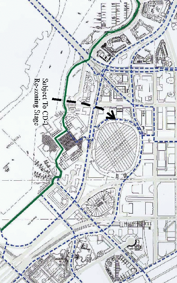
Figure 3 - Cyclist Routes
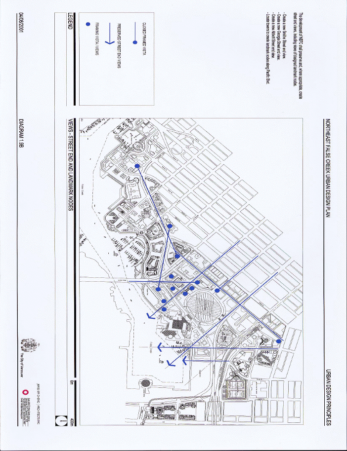
Figure 4 - Street-end Views and Landmark Nodes
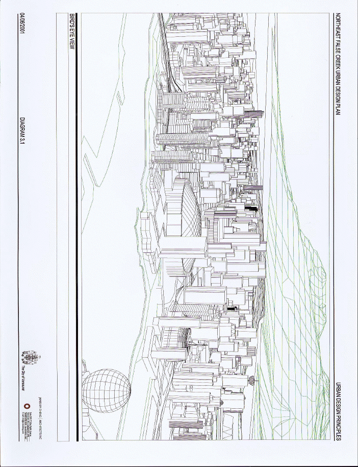 Figure 5 - Bird's Eye View
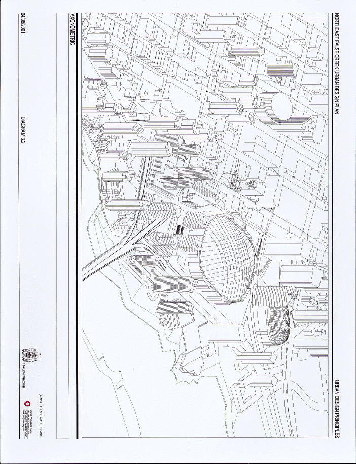 Figure 6 - Axonometric
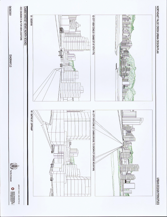 Figure 7 - Cambie Bridge Views
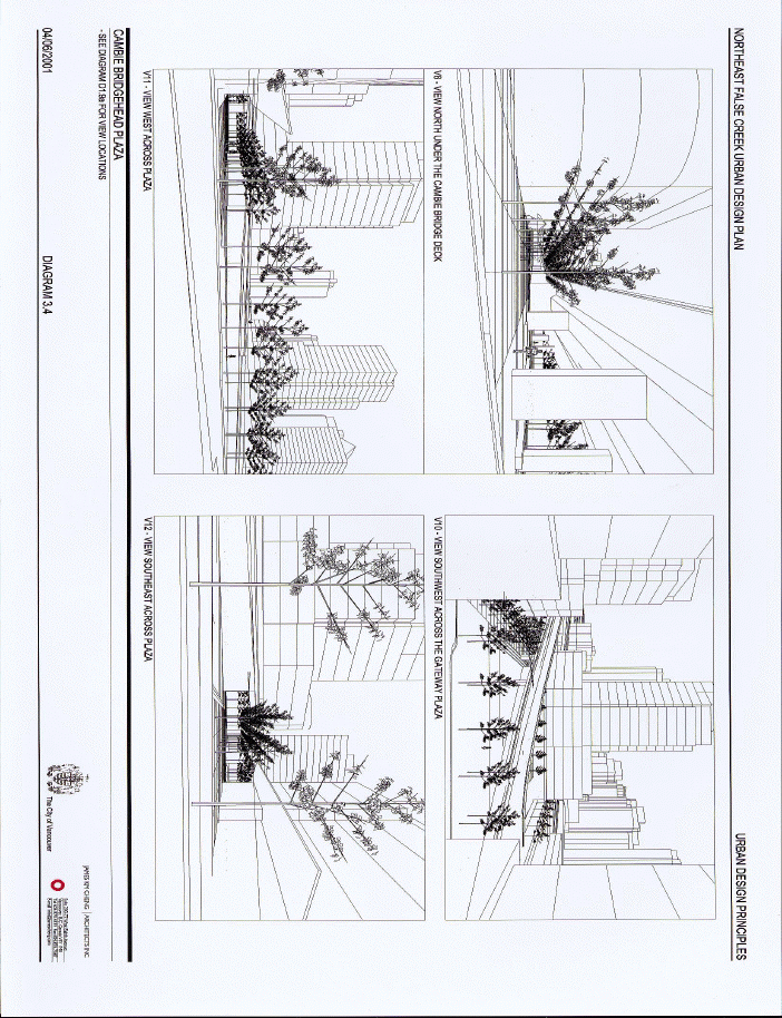 Figure 8 - Cambie Bridgehead Plaza Views
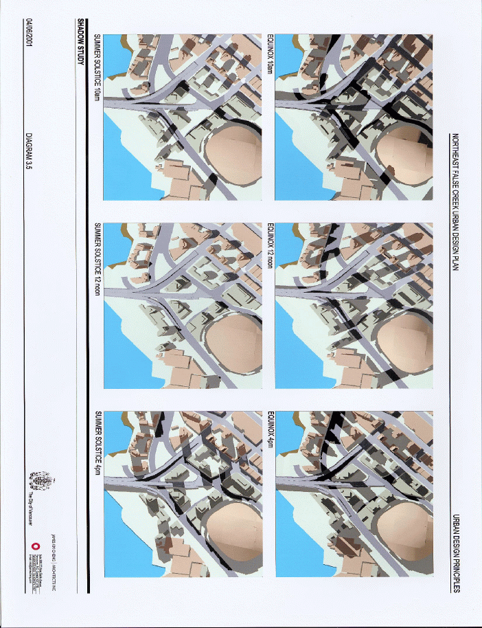 Figure 9 - Shadow Study
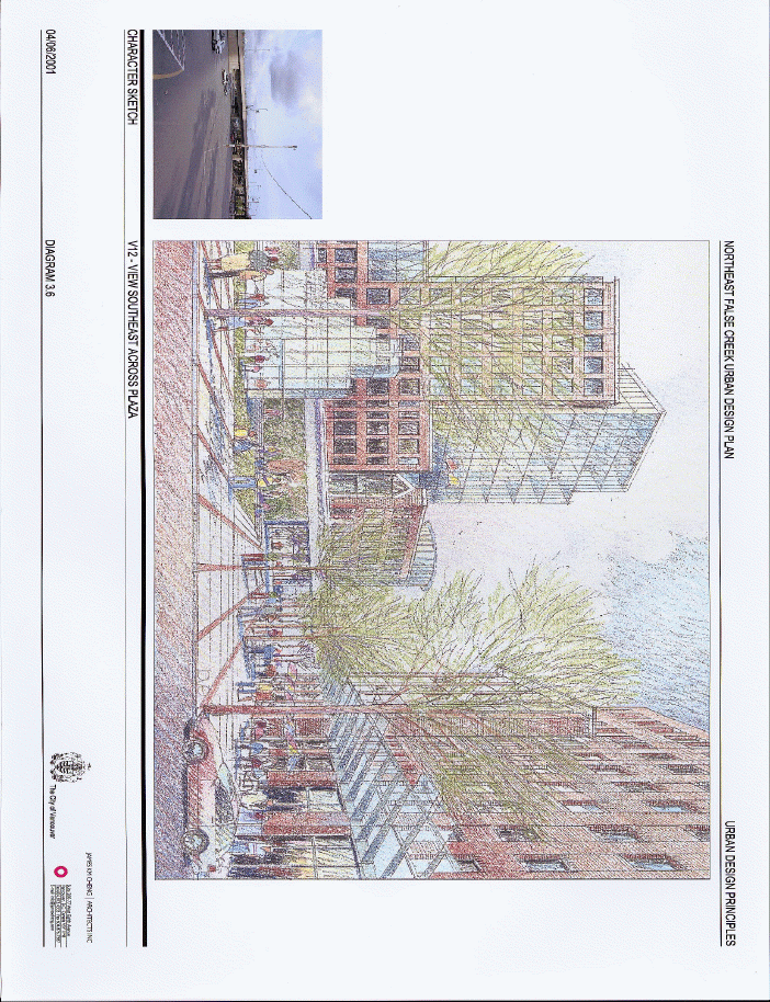 Figure 10 - Character Sketch Southeast Along Plaza
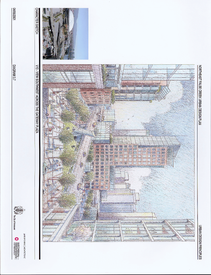 Figure 11 - Character Sketch Southwest Across Plaza
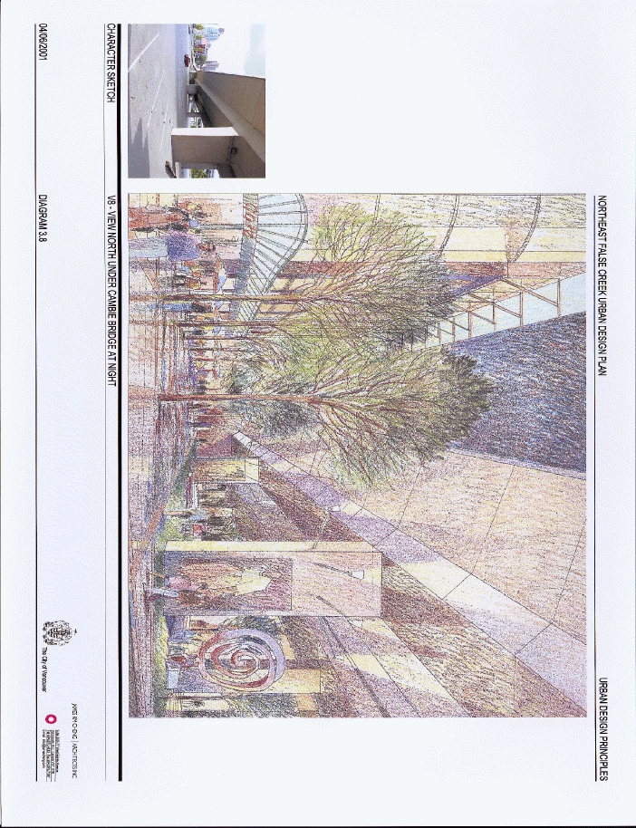 Figure 12 - Character Sketch Under Cambie Bridge At Night
Appendix E
Page 1 of 3
Summary of Comments Sheets Collected at Open Houses Jun 6 and June 14th, 2001
Question #1: Do you support the proposed relocation of office potential over to the Cambie Bridgehead closer to the Old Yaletown Area?
YES |
NO |
total responses |
29 |
8 |
37 |
78% |
22% |
|
|
Question #2: Do you support the creation of density on the BC Place Stadium site for office space, a conference centre and retail and similar uses fronting on the sidewalk?
| ||
YES |
NO |
total responses |
19 |
5 |
24 |
79% |
21% |
|
|
Question #3: Do you place value on improving the pedestrian environment and pedestrian connections in this area? | ||
YES |
NO |
total responses |
41 |
1 |
42 |
98% |
2% |
|
|
Question #4: Do you place value on improving cyclist connections through the area?
| ||
YES |
NO |
total responses |
36 |
5 |
41 |
|
88% |
12% |
|
|
Question #5: Do you support the creation of a new Gateway Plaza and activity node at the foot of the bridge? | ||
YES |
NO |
total responses |
30 |
6 |
36 |
83% |
17% |
|
Question #6: Do you support the extension of Smithe Street from Expo Blvd. across Pacific Boulevard? | ||
YES |
NO |
total responses |
26 |
8 |
34 |
76% |
24% |
|
Appendix E
Page 2 of 3
Question #7: What do you like about the proposed plan for the Northeast False Creek area?
COMMENTS total responses: 14
Positive comments about the proposed plan centered around factors which make the Northeast
False Creek area a more people friendly environment. These factors included smaller scale
"Yaletown style"" buildings, playgrounds, and public space, a better view of the water, as well
as an increase in residential zoning. Improvements to the bicycle and pedestrian infrastructure
were met with enthusiasm, with specific comments addressing the improvement to existing
crosswalks and the extension of Smithe St. and Georgia St., and another stating it was time
the city provided infrastructure for the stated transportation priorities.
Question #8: Are there any elements of the Northeast false Creek Plan that you dislike?
COMMENTS total responses: 23
Elements of the proposed Northeast False Creek Plan that were not liked were those which took away from existing views of the water front and BC Place, such as placement of tall buildings and office towers, the continued presence of the Cambie Bridge on/off ramps, increased density in residential and commercial areas, and increased motor vehicle access to the water front. There was a request for more green space, and it was suggested that Creek Side Park be built now. Some felt that increasing both residential and commercial density would leave more room for green space development, and lessen the ecological footprint in this area. Concerns expressed over bicycle pathways included the presence of too many intersections thus increasing potential for accidents, and that generally planning in this area is geared too much toward motor vehicles. It was requested that bike pathways connect along Yaletown, Chinatown and Beatty St. to the sea wall, and that #15 and #17 be realigned down Beatty St. Another would like to have Expo boulevard-north covered by a pedestrian bridge, while keeping traffic flow at sea level. Site 7B was described as clumsy, and convention center access from Pacific Blvd. south will lead to traffic chaos. Regarding recreational entertainment, there was a request for more active public spaces including a climbing wall, BMX track, skate park, and graffiti wall.
Question #9: Please outline the key issues that you feel are important in this area
-both general ( e.g. view, connections and improved pedestrian environment, new
community spaces) and specific (e.g.pedestrian /cyclist operational issues).
Please identify those of the greatest importance to you.
COMMENTS total responses: 29
Key issues that were identified as being important to this area included the maintenance and
improvement of the green space, public space and scenic views, the people friendly environment, and pedestrian and cycling infrastructure. More specific suggestions concerning green space and
Appendix E
Page 3 of 3
public space include building the Skate Park under the Georgia St. viaduct as planned, include a parked pathway from False Creek Seaside pathway through Creekside Park to Carroll St. A bike
pathway should be built along Quebec St. from Creekside Park to Chinatown and Pender St. Retention of some volley-ball courts, along the water's edge would be desirable. In terms of bike and pedestrian routes it was suggested that more bike racks be added, better lighting along commuter routes, and more sheltered areas for the wet weather, such as placing some recreation areas under Dunsmuir street viaduct and Georgia street viaducts near Beatty St.. A continuous sea wall connection around the Plaza of Nations.
Focus Groups and Public Meetings
In an effort to solicit input on the upcoming False Creek North ODP Amendment Dates,
a number of public sessions were held. Results from the Open Houses are outlined above, with additional information collected from focus groups and public meetings.
Three focus groups were held by invitation with selected stake holder groups. Tuesday
June 5 from 12-2pm, a Business lunch session was held at the Roundhouse Community
Centre Multi Purpose Room-C, a second one was held the same day from 7-9:30 pm with
Resident Groups at the Hampton Hotel, Belcarra Room, 3rd floor. Tuesday June 12 from 3-5 pm a discussion was held with Ped, Cyclist Recreational Transit Group, in Committee Room #3 City Hall 3rd Floor. It was suggested that the cobblestone be replaced by smooth pavement for the skateboarders, and that it is vital to connect the seawall walkway around the Plaza of Nations. Existing parking restrictions should also be maintained in this area, with no new parking areas added, while another felt that residential parking standards were too high. The Cambie crossing needs to be improved, as well as the Georgia St. viaduct entrance and exit. A bus route could go from Abbot St. to Pacific Blvd. to Smithe St., along with more sheltered bus stops along this and other routes.
Wednesday, June 20th a Bike Advisory Committee presentation was offered. Committee members cited that they would like to see the following:
1) improvements to the corkscrew exit off the Cambie bridge at the north end.
2) the Smithe Street extension between Expo and Pacific Blvd. made into a pedestrian street.
3) a formal extension of the waterfront walkway through the Plaza of Nations.
4) a barrier free access on the west side of stadium, connection from Robson to Pacific.
Community Directions, a group active in the east downtown, requested that future planning seek out economic and social development opportunities for the local population through the provision of training and jobs.
* * * * *
1 / This represents an addition of 30,515 sq. m (328,472 sq. ft) of office floor area to sub-area 10 (Phase One), on sites to the west and south of the existing Stadium..
2 / a) Manoeuvring lanes were excluded in the 18,815 sq. m allocated for the conference centre and expanded Stadium event space floor area because they are below-grade; b) Storage areas are included in the 18,815 sq. m allocated for the conference centre and expanded Stadium event space floor area; c) It should be noted generally that the total maximum additional floor area permitted in the current Phase One of ODP Amendments related to the Northeast False Creek Urban Design Plan is 49,330 sq. m (531,000 sq. ft.). Currently office uses are allocated at 30,515 sq. m (328,472 sq. ft) and conference centre and expanded Stadium event space at 18,815 sq. m (202,530 sq. ft.). At the CD-1 rezoning stage, these allocations may be adjusted further, however under no circumstances should the additional floor space for Sub-area 10 in Phase One exceed 49,330 sq. m (531,000 sq. ft).