|
|
POLICY REPORT
URBAN STRUCTURE
Date: June 15, 2001
Author / Local: P Mondor / 7727RTS No. 02143
CC File No. 5307
Council: June 26, 2001
TO:
Vancouver City Council
FROM:
Director of Current Planning, in consultation with the Director of Social Planning and the Director of the Housing Centre
SUBJECT:
CD-1 Rezoning: 335, 341 and 349 East 16th Avenue (proposed St. Elizabeth Home)
RECOMMENDATION
THAT the application by Davidson Yuen Simpson Architects to rezone this site (Lot A, Block 98, D. L. 301, Plan LMP 48729 ) from RM-4N to CD-1, so as to permit Special Needs Residential Facility - Group Living and Dwelling Use, be referred to Public Hearing together with:
(i) plans received May 07, 2001;
(ii) draft CD-1 by-law provisions, generally as presented in Appendix A; and
(iii) the recommendation of the Director of Current Planning to approve, subject to conditions contained in Appendix B;
FURTHER THAT the Director of Legal Services be instructed to prepare the necessary by-law for consideration at the Public Hearing.
GENERAL MANAGER'S COMMENTS
The General Manager of Community Services RECOMMENDS approval of the foregoing.
COUNCIL POLICY
Relevant Council Policies for the site are:
· Community Development Plan for Mount Pleasant, adopted October 1987;
· Special Needs Residential Facility Guidelines, adopted September 1983 and last amended February 1992;
· Mount Pleasant RM-4 and RM-4N Guidelines, adopted March 1990 and last amended January 1998; and
· Green Door / SHORT Process.
PURPOSE AND SUMMARY
The report assesses an application on behalf of the St. James Community Service Society to develop emergency accommodation and transition housing for women with children exiting abusive relationships. Rezoning is needed to accommodate two permitted uses in a mixed-use development. A small relaxation in building height on part of the site, a parking relaxation, and an accessory building (carport or garage) slightly in excess of outright approval provisions could be considered and approved in a development application under existing zoning regulations.
Staff have assessed the application and concluded that the proposal will have little negative impact on the surrounding neighbourhood and promises significant public benefit. Therefore the Director of Current Planning recommends that the application be referred to a Public Hearing and be approved.
DISCUSSION
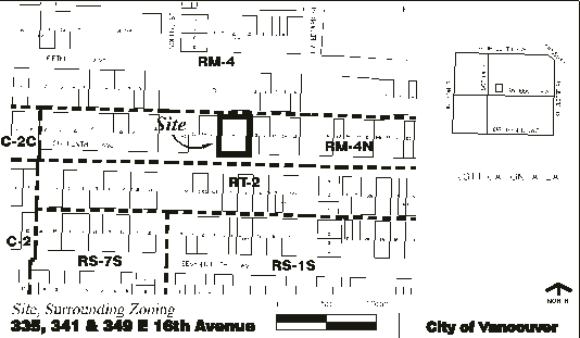
Site and Context: The site is comprised of three lots, each developed with a single-family dwelling, and which were recently consolidated. It is located in the Mount Pleasant apartment area east of Main Street and south-west of Kingsway. (See Figure 1 on the next page.) The site is about two blocks west of Main Street. Two blocks to the north on Prince Edward Street is Mount St. Joseph Hospital.
Across the lane to the north is an RM-4 District and across the street to the south is an RT-2 District. The north side of East 16th Avenue, between Main Street and Kingsway, was rezoned from RT-2 to RM-4N in 1989, implementing a recommendation of the Community Development Plan for Mount Pleasant to provide a better transition between apartment development in the area north of East 16th and lower-density housing development to the south. However, except for two small apartment developments, the RM-4N District has seen little change in its one- and two-family development and character.
Figure 1. Site and Surrounding Zoning, including Notification Area
Proposal: The application seeks rezoning to allow development of a four-storey building generally conforming to the RM-4 and RM-4N (Multiple Dwelling) Districts Schedule, except for permitted uses. The proposed non-market housing development would contain 18 sleeping rooms for emergency accommodation (Special Needs Residential Facility -Group Living) and 10 one-, two- and three-bedroom Dwelling Units for "second stage" (transitional) family housing. One floor of program and amenity space would be provided in the first storey, and two outdoor play areas are planned. Six parking spaces are proposed in a carport at the rear of the site and parking for fourteen bicycles.
St. James Community Service Society operates an emergency housing facility for women-in-crises and their families on Powell Street since 1986. A similar service is needed outside the Downtown Eastside to serve women with children from across Vancouver. Working with VanCity Enterprises and funding from BC Housing, CMHC and the Vancouver Richmond Health Board, the Society wishes to provide this service in a more central location where there will be good access to transit and services. They look forward to being in a moresecure anonymous address in a family-oriented neighbourhood.
Land Use: The intent of the RM-4 and RM-4N Districts Schedule is to permit medium density residential development, including a variety of multiple dwelling types, to encourage the retention of existing buildings and good design, and to achieve a number of community and social objectives through permitted increases in floor area. The RM-4N District differs from the RM-4 District in that it requires noise mitigation for residential development.
The proposed emergency shelter accommodation is defined as a Special Needs Residential Facility - Group Living. The facility would have 18 sleeping units on the second storey and multi-purpose space in the first storey comprised of kitchen and dining facilities, recreation rooms, meeting rooms and offices. The sleeping units, which would provide short-stay accommodation, do not have kitchens since the purpose of these suites and the multi-purpose space on the first floor is to provide a mutually supportive group setting.
The third and fourth floors would provide more conventional dwellings (ten one-, two- and three-bedroom dwellings). Providing for more independent living, this "second stage" or transitional family housing would ordinarily be defined as Multiple Dwelling use if not combined with another use on the site.
Special Needs Residential Facility (SNRF) and Multiple Dwelling are both permitted uses in the RM-4N District (as "conditional approval use" and "outright approval use" respectively). However, they could only be approved as a single, stand-alone use in a development. By contrast, in C (Commercial) Districts, Multiple Dwelling use can be combined with other uses in mixed-use developments as "Dwelling Units in conjunction with any of the uses listed in this schedule ..." Similarly in this proposed development, the dwelling use in the third and fourth storeys would be defined as: "Dwelling Units in conjunction with any of the other uses listed in this by-law".
( Note: Given the government funding and client type served, which would be the basis for a relaxation of parking requirements [discussed further on page 7], the use definition would be further extended to include this proviso: "... provided through government-funded programs, targeted for core-need households or for such other non-market housing programs or initiatives as Council may generally define or specially approve from time to time.")
While Special Needs Residential Facility - Group Living is permitted in this district, it is a conditional approval use subject to SNRF Guidelines which are intended to ensure that a proposed SNRF is compatible with the surrounding neighbourhood. One critical restriction is that "in a predominantly residential area, a special needs residential facility should be spaced at least 200 metres (656 feet) from another special needs residential facility." Social Planning staff have confirmed that this criterion has been met. There are three SNRFs nearby, in the 200-block East 11th Avenue, 200-block East 13th Avenue, and 500-block East16th Avenue, and all are more than 200 metres away. The nearest is 320 metres away.
Staff have also considered program characteristics including staffing and supervision, hours of operation, client type, facility capacity, referral and intake procedures, length of stay, and amount and type of traffic generated and parking demands. Staff considered physical characteristics which may have a bearing on the compatibility of the facility with the surrounding neighbourhood (e.g. site area, distance between proposed facility and adjacent dwellings or other uses, and existing traffic patterns on adjacent streets). Finally, staff confirmed that the facility will be serving a client type and providing a type of program which is not considered to be potentially disruptive to neighbours.
Staff therefore support the proposed SNRF use and the proposed combination of uses in a mixed-use development.
Density: The floor space ratio of proposed development is 1.45. In RM-4 and RM-4N Districts, the maximum density for all uses other than one-family and two-family dwellings is 0.75. However, this regulation may be relaxed to a maximum floor space ratio of 1.45 for Multiple Dwelling use provided that all required parking spaces are provided underground or within the outermost walls of a building, useable on-site open space is provided, a minimum of 20 percent of total units within the building contain two or more bedrooms, and site coverage does not exceed 65 percent.
The proposed development meets all these requirements but one. Parking is not proposed underground, because too few spaces are proposed to be economically feasible to construct underground. Underground parking is not a strict requirement in any case, and in RM-4 and RM-4N Districts can be relaxed if parking is provided in an enclosed or covered building.
A close review of the plans indicated that the carport at the rear of the site, which is 116.8 m² (1,257 sq. ft.) in size and 21.3 m (70 feet) in width, exceeds what is permitted outright for accessory buildings in this district (i.e. a floor area of 80.5 m² [866.7 sq. ft.] and width of 20.2 m [66.7 feet]). However, this can be considered and approved as a conditional approval use, and is supported by staff because the impact of slightly wider accessory building at the lane will be minimal. (Note: Accessory buildings are not include in FSR calculation.)
Form of Development: The proposed building form generally conforms to the RM-4 and RM-4N Districts Schedule and also the Mount Pleasant RM-4 and RM-4N Guidelines. It meets requirements with respect to minimum site area, maximum frontage, front yard minimum depth, side yard minimum width, and rear yard minimum depth.
The application received the unanimous support of the Urban Design Panel (see Appendix E, page 4). Among several supportive comments regarding the architectural expression of the proposed development, staff wish to draw attention to the Panel's encouragement "tolook for methods of softening the shoulders of the flat roof top." Staff feel a challenge here in that the proposed flat roof is consistent with the Mount Pleasant Guidelines, and is the norm in the apartment area to the north. Staff feel that it is the relatively prominent cornice which needs attention in this context, and so we recommend further design development to utilize different and lighter material expression for the fourth storey floor.
Related to the Panel's observations about softening the shoulders of the roof, staff note that although a fairly large deck area is proposed on the south-east corner of the fourth storey, the floor area in this storey exceeds 75 percent of the third storey floor area, as encouraged in the design guidelines. Staff therefore recommend that the applicant consider some additional fourth storey setbacks, although we recognize that the number of dwellings and their size and bedroom count is probably relatively fixed by the government funding earmarked for this proposal.
To achieve a contextual relationship with the character of the existing streetscape, the applicant proposes two bays on the front facade (south elevation) which match the width and roof proportions of the adjacent bungalows. Staff support this, and also the Urban Design Panels's encouragement that such bays also be considered for the rear elevation of the building.
Horizontal angle of daylight calculations for all the habitable rooms meet the By-law requirements, providing a 50-degree angle of view from the principal window in each habitable room. However, the building entrances are well below building grade, due to the sloping topography of the site. While two porticos are proposed to define the entries, giving them a clear definition while acting as a security buffer to the development, staff recommend further design development to increase the prominence and legibility of the main building entrance. Staff also concur with the Urban Design Panel's advice that the the proposed east side entrance be relocated closer to the street to improve livability for adjacent development to the east.
Staff support the proposed form of development but recommend further design development as described above.
Building Height: The maximum building height in this District is 10.7 m (35.1 feet), although there is provision to relax this with reference to the District Guidelines. The applicant requests a small increase, 0.84 m (2.75 feet), in the building height, up to 11.54 m (37.85 feet) at the north-east corner of the development, due to the sloping conditions on the site.
The site has a cross fall of 1.83 m (6 feet) from the southwest corner down to the northeast corner. To conform to the maximum building height, while retaining four storeys, would require the building to be pushed down such that the main floor would be about 3.0 m (10feet) below grade at the southwest corner of the property. We could anticipate some attenuation of this severe grade change from the street property line within the 6.1 m (20 feet) front yard setback area, however the applicant states that a retaining wall at the front of the site would be needed ranging from 1.37 m (4.5 feet) to 1.83 m (6 feet) high. The length of the ramp for disabled access would also have to be increased considerably, from 12.2 m (40 feet) to 22.86 m (75 feet).
Given the site's topography, staff support the proposed height relaxation because the front of the building would not exceed the maximum building height in this District, and the view and shadow impacts of proposed development would be comparable to other RM-4 and RM-4N development (see Shadow Impact in Appendix C, page 7).
Parking: Thirteen parking spaces would ordinarily be required for a proposed development like this. However, because of the proposed government funding and client type served (core-need households), the Parking By-law provides that a relaxation of parking requirements can be considered. Based on comparable non-market developments elsewhere in the city, staff advise that a minimum of six parking spaces should be provided, as proposed. Consistent with normal practice, staff therefore recommend as a condition of rezoning approval a housing agreement to secure 100% occupancy of the building by core need individuals and households.
Crime Prevention Through Environmental Design: To reduce opportunities for vehicle theft and theft from vehicles, and also to enhance the security of the development, staff recommend that a secured garage be provided instead of the proposed carport.
Community Amenity Contribution: The interim City-wide Community Amenity Contribution (CAC) Policy applies to the site however the proposed development would be exempt from CACs for the reason that it is social housing which, if approved, would be secured through a covenant.
Neighbourhood Response: Public input received through telephone calls, e-mail, letters and an Open House held by the applicant has been mixed. (About 12 individuals have commented.) A few concerns relate to the scale of development, which was to be expected as very little redevelopment has occurred since the RM-4N District on the north side of East 16th Avenue was rezoned from RT-2 in 1989. More concerns have been expressed about the proposed SNRF use and the anticipation that there will be increased noise, disruption, traffic, on-street parking, and social problems. Concern was also frequently expressed that there are already many SNRFs in the neighbourhood, particularly compared to west side neighbourhoods. A petition opposing the application, containing eleven signatures (with most of their addresses on the 300-block East 16th Avenue), was recently received.
CONCLUSION
Planning staff conclude that this application is consistent with City objectives and policies by proposing much-needed transition housing within a density and form of development generally meeting the requirements of the RM-4 and RM-4N Districts Schedule.
Rezoning is needed simply to accommodate two permitted uses in a mixed-use development. A small relaxation in building height on part of the site, a parking relaxation, and an accessory building (carport or garage) slightly in excess of outright approval provisions could all be considered and approved in a development application under existing zoning regulations.
Some further design development is recommended as conditions of rezoning to enclose the parking, reduce the impact of fourth storey massing, increase the legibility of the principal building entrance, and reduce the impact of the side entrance on adjoining development.
The Director of Current Planning recommends that the application be referred to a Public Hearing and that it be approved.
- - - - -
APPENDIX A
335, 341 & 349 East 16th Avenue
DRAFT CD-1 BY-LAWNOTE: These are by-law provisions which are subject to change and refinement by staff prior to the finalization of the by-law for the public hearing.
USES
· Dwelling Units in conjunction with any of the other uses listed in this by-law, provided through government-funded programs, targeted for core-need households or for such other non-market housing programs or initiatives as Council may generally define or specially approve from time to time;· Special Needs Residential Facility - Group Living; and
· Accessory Buildings and Accessory Uses customarily ancillary to the foregoing.
DENSITY
· Maximum floor space ratio of 1.45, and inclusions and exclusions from FSR calculations generally according to Sections 4.7.2 and 4.7.3 of the RM-4 and RM-4N Districts Schedule.HEIGHT
· Maximum building height of 10.7 m (35 feet), except that this may be relaxed to a height not exceeding 11.6 m (37.9 feet) at the north-east corner of the building.PARKING, LOADING AND BICYCLE PARKING
· According to the provisions of the Parking By-law, except that:
- a minimum of 6 parking spaces are provided,
- small car ratio provisions of the Vancouver Parking By-law shall apply, and
- a minimum of 14 class "A" bicycle spaces are provided.ACOUSTIC PROVISIONS
· Provisions of Section 4.15.1 of the RM-4 and RM-4N Districts Schedule shall apply.APPENDIX B
335, 341 & 349 East 16th Avenue
DRAFT CONDITIONS OF APPROVALNOTE: These are draft conditions which are subject to change and refinement by staff prior to the finalization of the agenda for the public hearing.
FORM OF DEVELOPMENT
(a) THAT the proposed form of development prepared by Davidson Yuen Simpson Architects, and stamped "Received, City Planning Department, May 7, 2001", be approved by Council in principle, provided that the Director of Planning, or Development Permit Board, may allow minor alterations to the form of development when approving the detailed scheme of development as outlined in (b) below.
(b) THAT, prior to approval by Council of the form of development, the applicant shall obtain approval of a development application by the Director of Planning, or Development Permit Board, who shall have particular regard to the following:
DESIGN
DEVELOPMENT (i) design development to reduce the impact of the overall bulk of the building through the consideration of fourth floor setbacks, different and lighter material expression for the fourth floor, and de-emphasis of the cornice;
(ii) design development to increase the prominence and legibility of the principal building entrance;
(iii) design development to provide a secured garage in place of the proposed carport;
(iv) design development to relocate the proposed side entrance closer to the street to improve the relationship with adjacent development to the east;
LANDSCAPE
REVIEW (v) design development to consider an increase in the amount of passive useable outdoor open space on site;
(vi) design development to the roof decks to include more planting;
(vii) further landscape development to ensure that all plants be child-safe i.e. non-poisonous;
CRIME PREVENTION
THROUGH ENVIRONMENTAL
DESIGN (CPTED) (viii) design development to minimize opportunities for crime through the use of CPTED principles (Crime Prevention Through Environmental Design), with particular regard for
-graffiti and vandalism in the lane area, and
-car crime in the lane,
through improved treatment of the rear lane and consideration of making the carport into a garage, with lattice between the shelter and the back wall of the garage.
AGREEMENTS
(c) THAT, prior to enactment of the CD-1 By-law, the registered owner shall, at no cost to the City:
SERVICES (i) Make arrangements, to the satisfaction of the General Manager of Engineering Services, for undergrounding of all new Hydro and Telus services for the development from the closest existing suitable service point, including a review of the servicing requirements to determine their impact on the surrounding neighbourhood.
NON-MARKET HOUSING AGREEMENT
(ii) Execute a housing agreement under Section 565.2 of the Vancouver Charter, on terms acceptable to the Director of Legal Services, to secure 100% occupancy for core need individuals and households, to the satisfaction of the Director of the Housing Centre.
APPENDIX C
Note: This electronic copy does not contain the 7 pages of plans provided in the hard copy.
APPENDIX D
ADDITIONAL INFORMATION
Site, Surrounding Zoning and Development: The site area is 1 122.05 m² (12,082.89 sq. ft.) and the site dimensions are width of 30.18 m (99 feet) and depth of 37.19 m (122 feet).
There is a very small park nearby, Tea Swamp Park, at the south-west corner of 15th and Sophia (frontage of 79.5 feet). Across the lane from the park to the south, at the north-west corner of 16th and Sophia, four City-owned lots (frontage of 148.5 feet at 259-295 East 16th Avenue) are intended for expansion of the park. Residents in the area have expressed concerns about the lack of maintenance and the uncertain timing of park development. Board of Parks and Recreation staff have been contacted about this.
There are two churches in the vicinity -- Seicho-No-Ie at the western end of the block (201 East 16th Avenue) and Bethlehem Lutheran Church across the lane (390 East 15th Avenue).
Proposed Form of Development: The proposed building form generally corresponds to that developed under RM-4 and RM-4N regulations elsewhere in the city. To ensure some contextual relationship with development in the existing neighbourhood, two bays on the front facade (i.e. the south elevation) are proposed to match the width and roof proportions of the adjacent bungalows. The detailing would be in the "arts and craft" vein with robust wood columns at the outer edges of the bays and wood panelling below the windows.
Proposed Open Space: Two play areas will be provided at grade. On the south side of the property an active play space will have a slide, play house and spring toy. In the rear yard, an area will be set out with a basketball hoop and a tricycle loop.
At the front of the property on the east side, a small contemplative space has been developed. A large deck on the top floor will offer a gathering space for the group with a southern orientation.
Since the entries are well below street grade due to topography, two porticos will define the entry points. While giving a clear definition to the entry points on the site, these enclosures will also act as a security buffer to the development.
Crime Prevention Through Environmental Design: Security will be a principle concern of the facility. The severe grade change at street property line, with a guardrail at the top, will be a primary barrier at the site's front side. To maintain the continuity of this barrier, a portal defines the two entry stairs which will each have a full height gate and intercom. Both of the building entrances will have a second intercom. A six-foot wood fence will define the sides and rear of the property.
Proposed Parking: Six parking spaces are proposed, as follows:
a) For 8 staff on average, requiring 1 space for each 4 staff, 2 spaces are proposed.
b) For the 13 units of the transition housing and the 10 units of "second stage" housing, proposed to have a ratio similar to SROs of 1 space for each 10 units, 3 parking spaces are proposed.
c) For visitors, one parking space is proposed.
Proposed Bicycle Parking: Fourteen bicycle parking spaces are proposed, as follows:
a) For 8 staff, requiring one space for each 8 staff, 1 bicycle parking space is proposed.
b) For the residents of the transition housing, which will not be bringing bicycles to the shelter, no bicycle spaces are proposed.
c) For the ten units of "second stage" housing on the third and fourth floors, requiring 1.25 spaces per unit, 13 bicycle parking spaces are proposed.
APPENDIX E
COMMENTS FROM PUBLIC, REVIEWING AGENCIES, AND APPLICANT
Public Input: A notification letter was sent to surrounding property owners (393) on May 8, 2001 and rezoning information signs were installed on May 31, 2001. As required by the Special Needs Residential Facility Guidelines, a second notification letter was mailed on June 8, 2001 providing additional information (sponsorship and program; client group; number, type and turnover of clients; number of staff; level of supervision; hours of operation; referral process; and funding).
Staff have received 8 telephone calls, 3 e-mail submissions, and 3 letters from residents. Most of the telephone callers wished to know more about the proposed SNRF and had no further questions or comments upon receiving an explanation from staff. Three of the callers expressed opposition to the proposed use, citing various reasons for this. All were invited to send their opinions in writing. Overall, some of the concerns relate to the scale of development, which was to be expected because very little redevelopment has occurred since the RM-4N District on the north side of East 16th Avenue was rezoned from RT-2 in 1989. More concerns have been expressed about the proposed SNRF use and the anticipation that there will be increased noise, disruption, traffic, on-street parking, and social problems. Concern was also frequently expressed that there are already many SNRFs in the neighbourhood, particularly compared to west side neighbourhoods.
An open house was held by the applicant team at Heritage Hall, two blocks west of the site, on June 5, 2001 (6:00- 8:00 PM). An estimated 23 residents attended; 19 completed the questionnaires provided: 7 supported the rezoning, and 8 were opposed. Much of the written commentary was about the density, scale, size, height, and character of the proposed development compared to the lower-density scale of existing development on East 16th Avenue. Some comments asked for a better look and character, less institutional and "character-less", and more "heritage" and "better-designed".
The three City staff present at the Open House heard concerns expressed about the scale and height of development from immediate neighbours, concerns about the character of development, and considerable concern about the proposed SNRF use. While the site meets the SNRF location criteria, some residents feel there is a predominance of SNRFs in this neighbourhood compared to many other parts of the city and they feel that there are already many SNRFs and non-market housing developments nearby. A resident questioned why the entire building is not described as a SNRF since it is the same client group which will be accommodated throughout. A resident feels that the requested height encroachment will have unacceptable view impact.
Comments of the General Manager of Engineering Services: "Engineering Services hasno objection to the proposed rezoning provided that:
- a minimum of 6 parking stalls are provided,
- 14 class "A" bicycle stalls be provided, and
- the small car ratio provisions of the Vancouver Parking By-law shall apply.Prior to enactment of the by-law arrangements are to be made, to the satisfaction of the General Manager of Engineering Services, for undergrounding of all new Hydro and Telus services for the development from the closest existing suitable service point, including a review of the servicing requirements to determine their impact on the surrounding neighbourhood."
Environmental Protection: "A site profile is not required for the above referenced site. No approval required from the Environmental Protection Branch for the Rezoning Application." (Note: Because of peat conditions in this area, a geo-technical report will be required at building permit stage.)
Environmental Services: "There are no requirements for soil remediation."
Vancouver-Richmond Health Board (Noise): "The City's acoustical criteria for the RM-4N District shall form part of the CD-1 By-law, and an acoustical consultant's report shall be required which assesses noise impacts on the site and recommends noise mitigation measures."
Fire Prevention: "The fire access is acceptable in principle. The applicant is advised to review spatial separation to the adjacent property lines, as this could be a Vancouver Building By-law issue at building permit stage. It should also be noted that some building code changes later in the year on accessibility issues may change some of the door sizes to the suites and within the suites. Probably not a big issue, but a heads up is recommended."
Crime Prevention Through Environmental Design: "The following design development conditions are recommended:
1. design development to take into consideration the principles of CPTED (Crime Prevention Through Environmental Design) having particular regard for;
-graffiti and vandalism in the lane area, and
-car crime in the lane; and2. design development to reduce opportunities for car crime in the proposed carport.
Note to Applicant: This carport is open to the lane and has no surveillance by the shelter residents which will provide a significant theft opportunity. The carport shouldbe made into a garage with lattice between the shelter and the back wall of the garage."
Landscape Review: "The following design development conditions are recommended:
1. design development to minimize opportunities for crime through the use of CPTED principles (Crime Prevention Through Environmental Design), with particular regard for mischief, graffiti and theft from auto, through improved treatment of the rear lane;
Note to Applicant: Covered parking, with a continuous hedge directly adjacent, will require an overhead security door to reduce opportunities for theft from and theft of auto.
Opportunities for graffiti can be reduced through the provision of hedging along the exterior sides of the fence adjacent to the basketball court and the eastern most bicycle storage.
Garbage enclosure will require a roll-up overhead door. Doors cannot swing out into laneway.
2. design development to increase the amount of passive useable outdoor open space on site; and
3. design development to the roof decks to include more planting."
Director of the Housing Centre: "This emergency shelter plus transitional housing project is endorsed as part of the Vancouver Agreement. Funding is provided by the federal government, the sponsoring society (St. James Community Service Society) and the BC Housing Management Commission through the Homes BC program. The East 16th Avenue project qualifies as Homeless/At Risk (HAR) and `Multi-service' housing (emergency shelter plus second stage housing). No City funding is involved.
St. James Community Service Society operates the Powell Place shelter. The proposal on East 16th Avenue will augment existing services for women and children in a location which is in closer proximity to families outside the downtown peninsula. The Housing Centre supports this application, subject to very minor adjustments at the development permit stage, as outlined in Appendix B. A housing agreement, to secure occupancy for core need individuals and households, is felt appropriate in view of the requested parking relaxation, based on the likelihood that residents will not own cars."
Director of Social Planning: "Social Planning supports this application. The project meets all the SNRF distance and locational guidelines. There is a pressing need for additionalhousing for women and children who are victims of violence, and this operator has a good track record with this type of program. It is particularly valuable to have an operator who has Downtown Eastside connections operating a resource outside of the Downtown Eastside, as this will help women to move from often-dangerous situations downtown to more stable neighbourhoods.
The applicant has clarified questions we had about the shelter use and the second stage housing, and related design questions. Please ensure that all plants to be used for landscaping be child safe i.e. non-poisonous."
Urban Design Panel: The Panel unanimously supported the application on May 30, 2001.
"EVALUATION: SUPPORT (7-0)
Introduction
Phil Mondor, Rezoning Planner, introduced the application submitted on behalf of the St. James Society Women's Shelter, and discussed the proposed use, developed according to the provisions of the zoning schedule, in the context of the surrounding neighbourhood. It was noted that there are small ways in which the application departs from the zoning schedule with the exception of its significant departure relating to use. Providing emergency accommodation (18 sleeping rooms) and transitional housing (10 dwelling units) for women and children, the intended use of the site is dwelling units combined with a special needs residential facility (group living). This is a combination of uses which is not permitted under the existing zoning, and is what requires a rezoning application.The Panel was informed that, although the zoning intends for this type of development, it would be the first four storey project on a street of one storey plus basement houses. Information was also provided on the enquires that the City has received since the public notification two weeks ago.
Eric Fiss, Development Planner, referencing posted drawings, provided general information regarding the intent of RM-4N zoning. Mr. Fiss then discussed the proposed form of development, noting it would set a precedent for further development in this zone to create a more distinctive architectural style.
The Panel's comments were sought regarding the character of the roof, street wall presence, articulation of the facade to respond to the adjacent buildings, landscape plan, whether extra height has been earned through the design, the project's response of the front yard to neighbouring front yards, its public open space, and its circulation and access.
Applicant's Opening Comments
Ron Yuen, Davidson Yuen Simpson, Rob O'Dea, Joseph Lau and Gerry Eckford, joined thePanel for consideration of this item.Mr. O'Dea commented that the applicant team has been working with a community group for a year on this proposal to house women and children in both short and long term transitional housing. Efforts have been made to stay within the existing zoning and neighbourhood context. The height is 2'9" above the height regulations in the rear, eastern corner, but the majority of the development is below the 35' limitation. It was noted that lowering the height would require including another ramp for wheelchair access.
Mr. Eckford commented on the project's landscape which was designed to provide a sense of home and appropriate play areas for the children. Issues of privacy and security of importance given the use were discussed and the rationale for the ramp design, and positioning of the interior spacial orientation was provided.
The applicant responded to questions regarding the overall design, its intended usage, neighbourhood consultation process underway, and the rationale for two entrances and for one of these to be a side entrance.
Panel's Comments
Generally, Panel members offered supportive comments regarding the project's architectural expression, notwithstanding one members' less favourable comments concerning the relation of the project's massing to the site size. It was agreed that the form of development with the approved zoning and the use are compelling and supportable.With respect to the treatment of the facade along the street, differing views were offered as to its value in breaking down the scale of the building in relation to its neighbours versus unnecessarily trying to make it not look like an apartment building. The applicant was encouraged to look for methods of softening the shoulders of the flat roof top, particularly at the lowest part of the site.
Panel members noted that the landscaping is done very well given the high level of programming necessary. Also, the height relaxation was universally supported and it was suggested that the project fits the RM4N zoning quite well given the height limitations.
Concerning the side entry, it was noted that its location is somewhat problematic and it was suggested that the applicant try to move the entry towards the front of the building and approach this as a test case with more of a set-back from the future adjacent building.
The Panel expressed its unanimous support for the application.
Applicant's Response
The applicant thanked the Panel for its comments."Environmental Implications: This development which will address the short-term housing needs of women and children in crises will represent a low impact on traffic and general activity patterns in the area.
Social Implications: The development of a major "transition house" to address the needs of women and children in crises outside the Downtown Eastside is socially beneficial for the city. The proposed development has positive implications with respect to the Vancouver Children's Policy or Statement of Children's Entitlements.
Applicant's Comment: "We would like to thank you for delivering the final report. We have reviewed the report and are in agreement with its conclusions. We will endeavour to resolve the outstanding issues as soon as possible.
We would also like to acknowledge both your work and that of the other members of City staff related to the project who have facilitated quick and effective resolutions to all issues. More than just the timely manner in which the project has been moved through the City process, we have appreciated the positive and supportive attitude that each staff member has brought to the project.
As you are aware, there is an ever increasing need for this project. There is an urgency to be in construction before the end of the year. On behalf of St. James Community Services, we would like to thank you and City staff for helping us to bring the project to fruition as soon as possible."
APPENDIX F
APPLICANT, PROPERTY AND
DEVELOPMENT PROPOSAL INFORMATIONApplicant Information
Applicant / Architect
Davidson Yuen Simpson Architects
Developer
St. James Community Service Society
Sponsors
VanCity Credit Union, BC Housing, Vancouver-Richmond Health Board
Property Information
Street Address
335, 341 and 349 East 16th Avenue (consolidated as 333 East 16th Avenue)
Legal Description
Lot A, Block 98, D. L. 301, Plan LMP 48729
Site Area
1 122.05 m² (12,082.89 sq. ft.)
Site Dimensions width
depth
30.18 m (99 feet)
37.19 m (122 feet)Development Statistics
Existing Zoning (RM-4N)
Proposed Development
Recommended
Land Use
Multiple Dwelling, SNRF, and other uses
SNRF - Group Living, and Dwelling Units in conjunction
as proposed
Floor Space
1 627 m² (17,525 sq. ft.)
as proposed
Floor Space Ratio (FSR) exclusion
maximum 10% for amenity area
163 m² (1,752 sq. ft.) 10%
as proposed
Density (FSR)
0.70 (relaxation to 1.45 for Multiple Dwelling)
1.45
as proposed
Height
10.7 m (relaxations may be considered)
11.5 m (4 storeys)
10.7 m, with relaxation to 11.6m at N.E. corner
Minimum Site Area
600 m²
1 122.05 m²
as proposed
Maximum Frontage
45.8 m
30.18 m
as proposed
Maximum Site Coverage
(65 percent, in Guidelines)
53 percent
as proposed
Min. Building Setbacks:
Front Yard
Side Yard
Rear Yard6.1 m
2.1 m
10.7 m6.1 m
2.1 m
10.7 mas proposed
Parking Spaces
1 / 93 m² for Multiple Dwelling (10 required) +
1/10 for sleeping units (3)6
as proposed
(relaxation)Loading Spaces
not required
0
n/a
Bicycle Spaces
14
as proposed
* * * * *

![[City Homepage]](/graphics/footnava.gif)
|
![[Get In Touch]](/graphics/footnavb.gif)
|

|

|

|
(c) 1998 City of Vancouver