ADMINISTRATIVE REPORT
Date: March 23, 2001
Author/Local: GM/FDucote6689/7795
RTS No.: 1920
CC File No. 113/5559
P&E: April 12, 2001
TO: |
Standing Committee on Planning and Environment |
FROM: |
Director of City Plans and the General Manager of Engineering Services |
SUBJECT: |
The Public Realm and Streetscape Element of the Broadway/Commercial Drive SkyTrain Station Precinct Plan and Parking By-law Changes |
RECOMMENDATION
A. THAT Council endorse the Public Realm and Streetscape element of the Broadway/Commercial Drive SkyTrain Station Precinct Plan, Appendix B, as a basis to guide capital planning, service plans and private initiatives;
B. THAT $90,000 for pedestrian lights and street furniture be allocated from existing funding in the Street Beautification and Street Trees Account #300000131;
C. THAT the following amendments to the Parking By-law for development in the Broadway/Commercial Drive station area, and the residential area south-east of the VCC Station be approved, as detailed in the report and Appendix C:
1. reduce minimum parking requirements for multiple residential use;
2. reduce minimum parking requirements for retail, service, office, restaurant, cultural, recreational, fitness centre and health care office uses; and
3. introduce a maximum parking standard for office, retail and service uses;
D. FURTHER THAT the Director of Legal Services be instructed to prepare the necessary by-law for enactment.
GENERAL MANAGERS' COMMENTS
The General Managers of Community Services and Engineering Services RECOMMEND approval of A through D, noting that this station precinct area poses unique challenges and that staff are continuing to work with the RTPO and TransLink on the implementation of the station designs, Greenways and station precinct plans.
It should be further noted that proposed street beautification and sidewalk repair elements are recommended to be funded through the City's Basic Capital Budget as opposed to the normal sharing with property owners in the Local Improvement Program. This is supported in this location because of the impacts of the rapid transit stations and the need to integrate these facilities into the community. The primary emphasis of the capital funding is on the need to provide a good, safe pedestrian environment.
COUNCIL POLICY
Staff will work with the Province on planning for the Phase 1 SkyTrain route, alignment, station locations, and station area planning.
In November 2000, Council endorsed the basic transportation, traffic and street change elements from Grandview Highway North to East 12th Avenue to allow staff to proceed with detailed design and to implement the changes in time for system start up.
In March, 2000, Council approved a text amendment for the CD-1 zoning of 1700 East Broadway to permit its use for a transit station, as well as associated retail uses.
In June 1998, Council approved the Kensington/Cedar Cottage Community Vision that calls for a pedestrian friendly transit hub and neighbourhood centre in the Broadway/Commercial Area.
In May 1997, Council approved the Transportation Plan which emphasized the need for improved pedestrian facilities, and the identification of a pilot project for testing the "pedestrian priority area" concept through implementation of a CityPlan visioning process.
SUMMARY
Since February, 1999, City staff have worked with the RTPO, TransLink and the public in planning the "Millenium" SkyTrain line in the Broadway corridor. Station precinct planning has been a major staff focus. This report recommends improvements to the sidewalks, street areas, major intersections and connecting streets in the vicinity of the new Commercial Drive and existing Broadway SkyTrain stations. There is strong public support for these measures. Funding is derived from the SkyTrain budget, Municipal Integration Fund, the Access Agreement and the City's street maintenance program. Because of the unique conditions that the SkyTrain system imposes on the Broadway/Commercial community, staff recommend the allocation of Capital Plan funds to help implement this public realm plan and the neighbourhood centre directions in the Kensington/Cedar Cottage Community Vision.
With the increased high level of transit services available, staff recommend a reduction of parking requirements for new development near the Broadway and Commercial Drive stations and the VCC station. Staff are reviewing details of the parking proposals with local residents and businesses and will advise on public response when Council considers this report.
PURPOSE
· to seek Council endorsement of the Public Realm and Streetscape element of the Broadway/Commercial Drive SkyTrain Station Precinct Plan; and
· to recommend changes to the Parking By-law as part of an overall parking management plan for the area.
BACKGROUND
In June, 1998 the Province announced construction of Phase 1 of a SkyTrain Extension from New Westminster to Vancouver, via the Lougheed/Broadway corridor. In Vancouver, the alignment follows the Burlington Northern Sante Fe Railway corridor and Grandview Cut from Boundary Road to Keith Drive, with a terminus station north of Vancouver Community College (VCC). Vancouver SkyTrain station locations are: Rupert Street, Renfrew Street, Commercial Drive, and VCC. The Phase 1 "Millennium" line will connect with the original SkyTrain "Expo" line at Commercial Drive and Broadway.
On February 23, 1999 Council resolved that any endorsement by the City of Phase 1 alignment or station locations be conditional upon the Province completing a comprehensive review of safety and security issues, and responding to the concerns of the community andCity staff in the design process. Council also directed staff to work with the Province's Rapid Transit Project Office (RTPO) on station design and precinct planning.
Since then, staff have worked with the RTPO and TransLink in planning the SkyTrain system. The scope of work includes transit interface planning, refinements of the guideway alignment, Greenway and bikeway planning and design, station precinct planning and refinements of station designs. The process for Broadway/Commercial included extensive public consultation by both the City and RTPO, and the participation of a neighbourhood working group composed of residents and business people.
On July 25, 2000 Council received a report on the Commercial SkyTrain Station Design and directed staff to report back on the Precinct Public Enhancement Plan for the Broadway/Commercial Station Precinct. On November 21, 2000 Council approved transportation, traffic and street changes for Commercial Drive from Grandview Highway North to 12th Avenue.
DISCUSSION
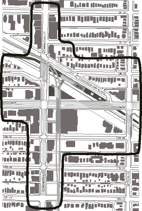
This report recommends improvements to the public realm surrounding the new Commercial Drive Station and the existing Broadway Station. These two stations and the related bus circulation and stops introduce many challenges to the street and pedestrian network in the area (see Figure 1).
Figure 1. Broadway/Commercial Drive Station Precinct

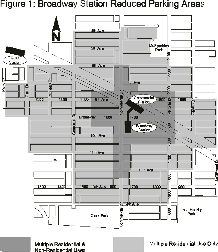
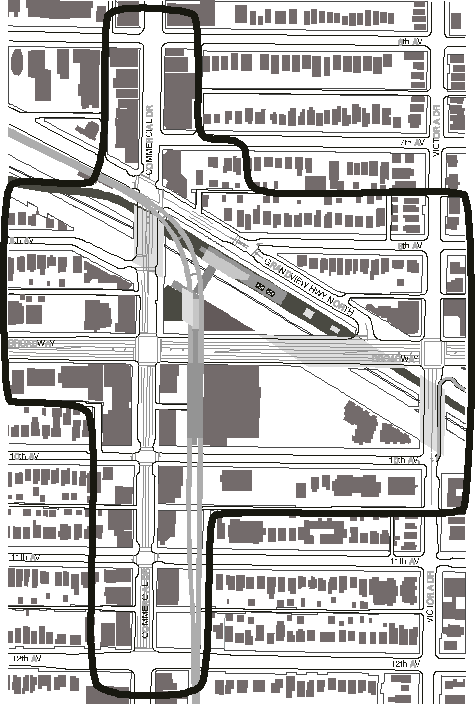
The area subject to proposed Parking By-law changes is shown in Figure 2.
This report is one of the interrelated elements that comprise the Broadway/Commercial Precinct Plan, which either have or will be reported to Council. These include:
· Transportation element - approved, November 21, 2000 (Appendix A);
· Commercial SkyTrain Station Design - reported, July, 2000;
· Public Realm and Streetscape element - (Appendix B);
· Parking By-law changes - (Appendix C); and,
· Urban Design element - (forthcoming report on commercial zone design guidelines).
Other work in progress includes relocating the Cedar Cottage Community Policing Office and redevelopment of the CIBC site adjacent to Broadway Station.
The Precinct Plan - Public Realm and Streetscape
SkyTrain Station precinct plans identify changes needed to improve pedestrian and transit access and connections to stations, and integrate stations into surrounding neighbourhoods. The Broadway/Commercial plan is also intended to implement approved public realm directions in the Community Vision for the neighbourhood centre, and demonstrate how the "pedestrian priority area" policy of the Transportation Plan may be achieved.
Like endorsed plans for the Rupert and Renfrew Stations, this plan includes improvements to sidewalks and street areas, major intersections and connecting streets. These will facilitate effective connections between the SkyTrain stations and the adjoining street and pedestrian network. These changes are funded by of the SkyTrain project or the Municipal Integration Fund (MIF) jointly shared between TransLink and the Rapid Transit Project Office.
The plan proposes additional improvements to Commercial Drive beyond SkyTrain scope and MIF, particularly between Broadway and 12th Avenue, to enhance the street's appearance and pedestrian-friendliness. The road, curb and sidewalk areas had previously been identified for major rehabilitation. The road structure and surface conditions are poor, and sidewalks have heaved near street trees and require replacement. $340,000 will be included in the 2001 Streets Basic Capital Plan for this work.
Decorative pedestrian lights will be attached to existing poles, and street furniture provided, including benches, trash receptacles and bike racks. The use of Capital funds was identified in the 2000-2002 Capital Plan for Vision Implementation. Staff recommend that $90,000 be allocated from the current Street Beautification and Street Trees Account in the Streets Capital Budget for lighting and street furniture in the plan area.
The plan contemplates the incorporation of public art in the public realm, likely at a later date, since no funding source is currently available.
Taken together, these public realm improvements will enhance the amenity of the area, move toward meeting the Community Vision directions for the neighbourhood centre, and demonstrate how the pedestrian priority area policy can be achieved. As a measure of policy consistency, Appendix D compares the precinct plan's initiatives, and others previously approved by Council, with approved KCC Vision directions.
Proposed Parking By-law Changes
In recognition of significant increases in transit service levels, staff recommend amendments to the Parking By-law to reduce commercial and multi-family parking requirements for new development in the Broadway/Commercial and VCC station catchment areas as shown in Figure 2. There is precedent for parking reductions near rapid transit service, notably at Collingwood Village, and similar amendments should be applied here.
Recommended changes to Parking By-law standards to take effect in the Broadway Station Precinct are as follows (standards are minimum required except as noted):
1. Multiple Residential Use: 0.75 space per dwelling unit + 1 space per 250 square metres GFA, except 0.5 space per dwelling unit less than 50 square metres GFA
2. Retail, Office, and Service Use: 1 space per 70 square metres GFA, except 1 space per 100 square metres GFA up to 300 square metres GFA (minimum); 1 space per 46.5 square metres GFA (maximum)
3. Cultural and Recreational Use: 1 space per 70 square metres GFA, except 1 space per 100 square metres GFA up to 300 square metres GFA
4. Fitness Centre Use: 1 space per 25 square metres GFA
5. Health Care Office Use: 1 space per 35 square metres GFA
6. All Other Uses: As per the Parking By-law
These recommendations are supported by recent studies as detailed in Appendix C. The parking amendments respond to the concentration of transit service in the Broadway/Commercial area, and to a growing awareness of the constraints placed on new commercial and mixed-use development by existing regulations.
Consultation Process
Public input derived from SkyTrain-related meetings held in 1999 and 2000 as well as the earlier Kensington/Cedar Cottage Community Vision program have shaped the plan. The City and RTPO have worked closely with residents, businesses and community organizations, including the Cedar Cottage Neighbourhood Association, Trout Lake Community Centre, Cedar Cottage Neighbourhood Safety Office, Grandview-Woodland Area Council and Cedar Cottage Neighbourhood House. The plan also responds to conclusions of the Special Commission for SkyTrain Review, released in May, 1999.
Figure 2. Area Subject to Parking By-law Amendments
The consultation process identified a number of challenges facing integration of a new SkyTrain station into the fabric of the community, including the need to:
· Increase safety and security around the SkyTrain stations;
· Improve the Commercial Drive streetscape;
· Develop the Central Valley Greenway/Bikeway;
· Improve connections between the new station, bus stops and the existing station;
· Create special places;
· Improve pedestrian connections;
· Manage traffic and parking;
· Relocate the Community Policing Office; and,
· Redevelop key underutilised sites.
The consultation process concluded that the core of the neighbourhood centre should be at a more pedestrian friendly location than Broadway and Commercial. The plan recommends that seating areas, feature landscaping and public art be located at Commercial and 10th Avenue. This will complement corner bulges approved by Council last November, 2000. for this intersection and others to reduce crossing distances and provide space for these features
There was also strong public support for strengthening pedestrian links between shopping areas along Commercial Drive north and south of the Grandview Cut, Measures have been included in the MIF and the Access Agreement negotiated between the City and the RTPO to make the Commercial Drive Bridge more attractive and pedestrian-friendly, with improved crosswalks and with active storefronts at the new station corner. The Access Agreement provides an amenity package in return for access to City streets and to the Grandview Cut.
Staff are currently reviewing details of the parking proposals with local residents and businesses and will advise on public response when Council considers this report.
Remaining Work - Built Form and Parking Management
Staff are working with the public to refine design guidelines for the C-zoned districts between 6th and 16th Avenues with a particular emphasis on creating a special character and neighbourliness. An updated area parking management plan is also in the work program, beyond By-law changes in Recommendation C. On-street parking restrictions were established after the Broadway Station was opened. These will be reviewed and augmented as necessary after the new Commercial Drive Station opens. As well, staff are exploring opportunities to provide collective parking for the commercial area, and will report progress to Council.
FINANCIAL IMPLICATIONS
Funding for improvements already approved by Council and in this Precinct Plan are derived from the SkyTrain budget, Municipal Integration Fund, the Access Agreement, the City's street maintenance program, and the Capital Plan. Funds were included in the Capital Plan for implementation of pedestrian priority areas. Some works traditionally funded by cost sharing with property owners through local improvement programs are to be derived in this instance from Capital Plan accounts, totalling about $90,000, because of unique conditions in the area. Broadway/Commercial hosts two rapid transit stations with their attendant impacts on the community. Hence, staff recommend a proactive approach to mitigation.
CONCLUSIONS
The Public Realm and Streetscape element of the Broadway/Commercial Drive SkyTrain Station Precinct Plan is the catalyst for integrating the new SkyTrain station's development into the surrounding community and will help implement many of the approved directions of the community vision. Because of the unique circumstances of this transit node, staff recommend a proactive City role in implementing the vision.
With the increased high level of transit services available, it is appropriate to consider a reduction of parking requirements for new development conveniently located to the Broadway and Commercial Drive stations and for multi-family developments near the VCC station.
* * * * *
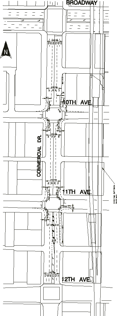
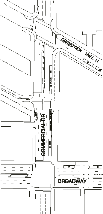
APPENDIX A
Grandview Highway North to12th Avenue
On November 21, 2000, Council approved this concept for street and transportation improvements.
APPENDIX B
Broadway/Commercial Drive SkyTrain Station
Precinct Plan
March 20, 2001
Public realm and streetscape element
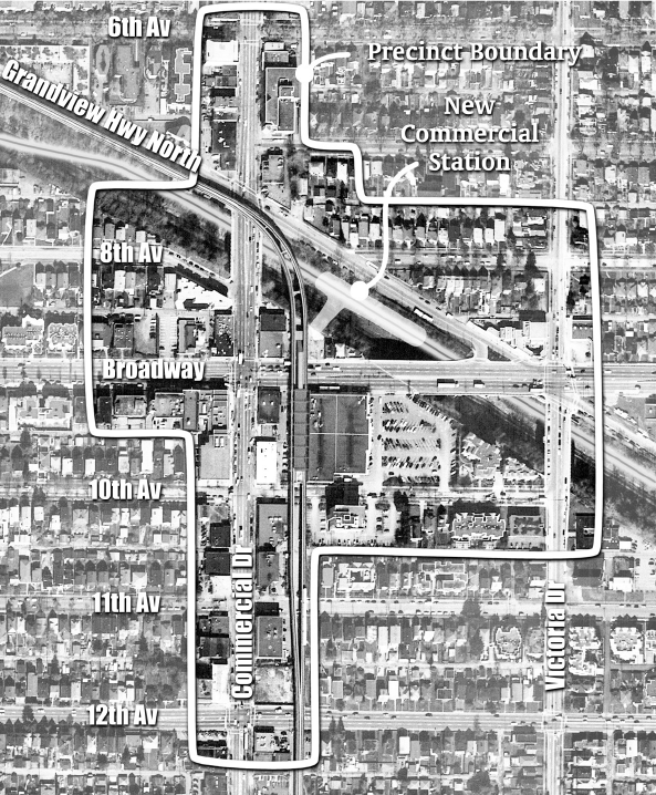
Table of Contents
Introduction and Scope 1
Area Planning
Area Planning 2
Vision 3
Issues and Opportunities 4
Existing Conditions 5
Streetscape Element 6
The Plan 6
Details 8
Further Work 10
Figures
1. Station Precinct 1
2. Central Valley Greenway/Bikeway 3
3. Commercial Drive Existing Street Conditions 5
4. Streetscape and Public Realm Plan 6
5. 10th Avenue and Commercial Drive Design Concept 8
6. Sketches 9
Introduction and Scope
The Public Realm and Streetscape element of the Broadway/Commercial Drive Station Precinct Plan is intended to provide the basis for coordination of SkyTrain-related transportation, greenway, bikeway and street improvements with other public and private initiatives generally in the area shown in Figure 1. Not all of these enhancements will be achieved through SkyTrain construction and municipal integration funding. However, the various enhancements are identified and summarized so that when funding sources do become available, they can be undertaken as part of an approved area plan. Efficiencies and partnerships can then be achieved that wouldn't otherwise be possible.
Figure 1: Broadway/Commercial Drive Station Precinct
The scope of this plan includes the following:
· Commercial Drive from the north side of 12th Avenue to the north side of Grandview Highway North;
· The west and south sidewalks adjacent to the new Commercial Drive Station and triangle site;
· Coordination with the 10th Avenue Greenway/Bikeway development;
· Coordination with the Central Valley Greenway/Bikeway segment of Grandview Highway North from Commercial Drive to Victoria Drive, and
· Coordination with a City bikeway on 10th Avenue and Victoria Drive
The Broadway/Commercial Drive Precinct Plan is composed of a series of closely related elements.
For practical purposes they have been or will be delivered separately. They include:
Transportation element - approved by Council November 21, 2000
Public Realm and Streetscape element
Parking By-law amendments
Urban Design element (land use, zoning and design guidelines)
Parking Management element
Area Planning
Planning and consultation in the Broadway/Commercial Precinct Area has been subject to a variety of initiatives, including:
Community Vision. The Kensington/Cedar Cottage Vision was approved by City Council in July 1998, and includes a number of broad as well as specific directions to improve conditions in the Broadway/Commercial area. The approval of the Kensington/Cedar Cottage Vision led to a City commitment to implement as many of the approved directions as possible. The announcement of the proposed Station at Broadway and Commercial Drive during the same time period also provided an opportunity to coordinate the SkyTrain station improvements with the surrounding area, especially along Commercial Drive.
SkyTrain Extension. In June 1998 the Provincial government approved a phased SkyTrain extension that includes a 4 kilometer section extending from Boundary Road to Vancouver Community College via the BNSF Railway right-of-way and the Grandview Cut. Four station locations have been identified to date, at Rupert, Renfrew, Commercial and north of Vancouver Community College.
Transportation Initiatives. Removal of Grandview Highway North and Commercial Drive between Grandview Highway North and Broadway from the Truck Route Network;
elimination of peak-period parking restrictions in parts of Commercial Drive, and
construction of bus bulges at Commercial Drive and 6th and 14th Avenues.
Precinct Planning. The precinct planning process has included input from the general public and local residents and business owners. A working group consisting of local residents and business owners was also formed to review the progress and make further recommendations. A design charette was held in June 1999 to generate and explore various alternatives.
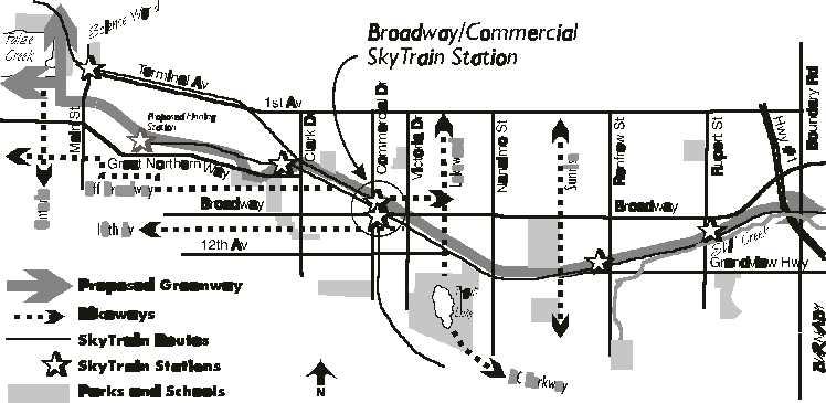
Greenway/ Bikeway Planning and Implementation. The Central Valley Greenway/Bikeway will eventually run from False Creek to Boundary Road to link into Burnaby's greenway network when it is complete (Figure 2). The Greenway/Bikeway passes through the precinct along Grandview Highway North on the north side of the Commercial Drive Station site. Also, the proposed 10th Avenue Bikeway will also be an important local neighbourhood connector for pedestrians and bicyclists passing east-west through the precinct. The implementation of these area amenities is being undertaken through separate processes.
Figure 2: Central Valley Greenway/Bikeway
Vision for the Area and the Precinct
The approved directions for the Broadway and Commercial shopping area state that it should be a high priority to enhance public and pedestrian safety and comfort, support its role as a transit hub, and strengthen the shopping vitality of Commercial Drive.
Issues and Opportunities
The SkyTrain Extension public consultation process highlighted the challenges of integrating another SkyTrain station into the fabric of the community; these include:
· Safety and security around the SkyTrain stations: A major ongoing public concern is the need to improve safety and security around the existing Broadway SkyTrain. Suggestions include improvement lighting, transparency and better maintenance. The recommendations of the system-wide safety and security study are to be incorporated into the retrofit of the existing Broadway station as well as the new Commercial Drive Station. As well, a new location for the Cedar Cottage
· Community Policing Office should contribute to achieving this objective.
· Revitalizing Commercial Drive: The revitalization of Commercial Drive`s physical appearance and pedestrian amenity is a precondition to attracting private investment and an improved local identity. . Enhancements include sidewalk treatment, street tree infill, pedestrian lighting, street furniture (bus shelters, benches, bike racks and trash receptacles) and public art.
· Central Valley Greenway/Bikeway: The development of a large segment of the Central Valley Greenway on Grandview Highway North as part of the SkyTrain Extension is also intended to help mitigate for the loss of vegetation in the Grandview Cut, a highly valued community green corridor.
· Access to and connections between the existing and new SkyTrain stations, buses and the existing station: Accommodating a smooth flow of patrons from one station to the other and to surrounding bus stops and destinations is vitally important. Visual connections, attractive waiting areas and ease of access are recommended to minimize potential conflicts.
· Special places: A number of recommendations have emerged from the consultation process to provide public spaces in the area, including a public plaza at the entry of the new station, introducing a neighbourhood focus at 10th and Commercial Drive, and improving the Commercial Drive bridge as an enhanced pedestrian connector in the community.
· Pedestrian connections: Beyond Commercial Drive and Grandview Highway North, a number of other potential connections have been identified for bicyclists and pedestrians. These include enhancement of 10th Avenue as a Greenway/Bikeway. Corner bulges at key intersections also move in the direction of improving the pedestrian circulation of the Drive.
· Traffic and parking management: Managing traffic and parking impacts in the area continues to be both a concern and a high priority. In addition to being a major regional transit hub, the intersection of Commercial Drive and Broadway is a high volume vehicular intersection. Corner bulges and bus bulges will restore balance between pedestrians and vehicular traffic. Peak period parking restrictions have been eliminated on part of Commercial Drive, providing both more hours for shoppers but also maintaining the buffering effect for sidewalk activities. Parking By-law amendments that reflect the significant transit investment in the area will be put forward for Council consideration.. Also, opportunities exist to expand commercial area parking adjacent to the existing elevated guideway east of commercial Drive.
Existing Conditions
Figure 3 shows some of the problems that affect comfortable pedestrian movement in the precinct. In some places curbs are almost non-existent, in others, the sidewalk is narrow for the existing and expected pedestrian volumes. In a few places tree roots have uplifted the sidewalk slab. Street improvements outlined in this report are intended to rectify these problems.
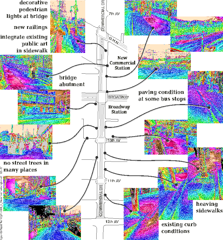 Figure 3: Existing Conditions
The Streetscape and Public Realm Element
Figure 4 summarizes the components of the public realm and streetscape. With the exception of 4f, a parking and neighbourhood greenway adjacent to the existing elevated guideway, all other changes have been approved by Council.
Figure 4: Plan Components

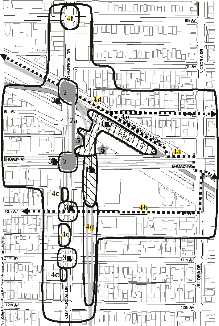
Details
The SkyTrain Extension consultation process identified the intersection of 10th Avenue and Commercial Drive as a potential major focal point for the neighbourhood centre to serve as a public gathering place. Figures 5 and 6 illustrate ideas for the enhancement of this intersection with corner bulges, special paving, seating, landscaping and public art. The bulges, paving treatment and landscaping for the intersection of Commercial and 11th Avenue are similar.
Figure 5: 10th Avenue and Commercial Drive Design Concept
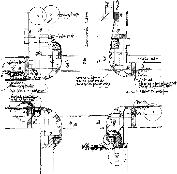
Figure 6: Sketches
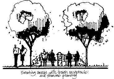
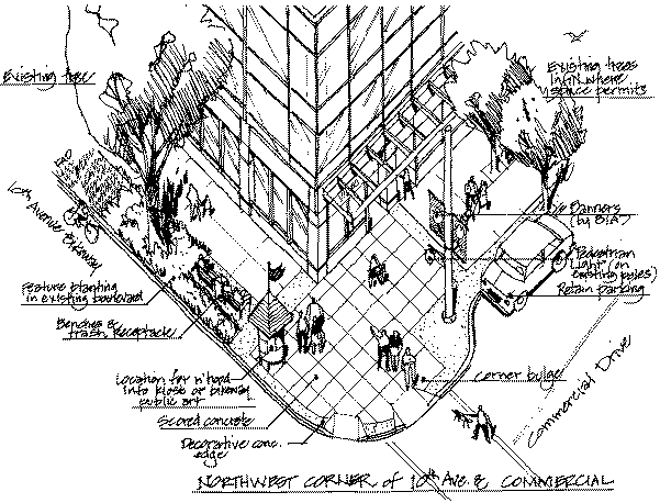
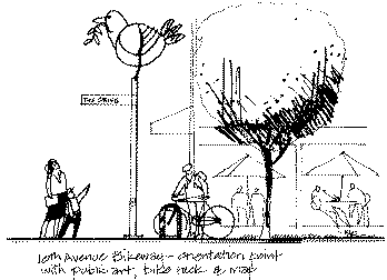
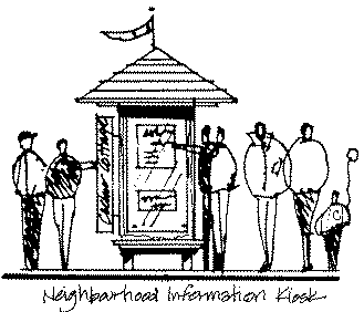
Further Work
Parking: To report back with a concept for collective parking adjacent to the elevated SkyTrain guideway east of Commercial Drive between 10th and 12th Avenues, including screening and pedestrian connections.
Design Guidelines: To report back on design guidelines for the C-2C, C-2C1 and C-3A zones between 6th and 16th Avenues, with the intent of establishing preferred character, retail continuity at grade between Broadway and 12th Avenue, employment opportunities, and a vibrant mixed use precinct.
Business Association Support: to provide initial support to efforts by the business community to organize itself for the purposes of retail mix, promotion, maintenance and other initiatives.
Summary
The Public Realm and Streetscape element of the Precinct Plan is to be used to direct City Capital funds and private initiatives associated with redevelopment of sites within the Broadway/Commercial Station Precinct.
APPENDIX C
PARKING STANDARDS FOR THE BROADWAY STATION PRECINCT
Once the Millenium Line of SkyTrain is completed, there will be two rapid transit lines serving the area surrounding Broadway and Commercial Drive. With the increased and high level of transit service available, it is appropriate to consider a reduction of parking requirements for new developments located conveniently to Broadway Station (see Figure 1). The City has some precedents for reducing parking in the vicinity of rapid transit service, and these could well be applied here. Reduced parking standards for various uses are discussed below.
Multiple Residential Use
For market multiple residential development, vehicles are owned (or not owned) for a variety of reasons. Proximity to rapid transit was found to be a factor in a joint study of vehicle ownership by Bunt Consulting and the City in 1996. That study looked at multiple residences in East Vancouver and Burnaby both near and away from rapid transit service, to assist in a review of the standard for Collingwood Village, near Joyce Station.
The Bunt/City study found that 20 percent of households in Collingwood Village did not own a motor vehicle. While vehicle ownership was found to increase with the size of the dwelling units, as expected, overall ownership for units less than 600 metres removed from rapid transit service was found to be about one-tenth of a vehicle less than for units greater than 600 metres removed. Furthermore, vehicle ownership was found to be significantly less than the multiple residential parking standard for RM-4 districts, commonly in effect. Except for small dwelling units, the standard for C districts also proves excessive near rapid transit, and elsewhere, in East Vancouver.
For the Broadway Station Precinct, the multiple residential parking standard determined in the 1996 study could and should be applied. That standard, adopted for Collingwood Village and other rezonings in East Vancouver since, is 0.75 space per dwelling unit + 1 space per 250 square metres of gross floor area (GFA). For a mid-sized 90 square metre unit, this would yield a requirement for 1.11 parking spaces, compared with 1.29 spaces for C districts and 1.55 for RM-4 districts, reductions of 14% and 28%, respectively. The new standard would include a component for visitors, and see those households owning more than one vehicle offset by those owning none. In response to the very low vehicle ownership expected among the smallest residences, a discounted rate of 0.5 space per dwelling unit should be applied to those units less than 50 square metres GFA. These standards should be applied to the larger area circumscribed on Figure 1, representing properties located within about 600 metres, or a six-minute walk, of the stations.
Retail, Service, and Office Use
For retail, service, and office (other than health care) uses in C districts, the Parking By-law requires one space per 100 square metres GFA up to 300 square metres, then one space per 50 square metres above 300 square metres GFA. There is no regulation of the maximum parking permitted. The standard was last reviewed in 1994 for Central Broadway and outlying commercial areas, and found to be appropriate, if somewhat under the demand encountered.
In consideration of the increased transit service forthcoming, the parking requirement should be reduced. There is a precedent, in place for office use in East False Creek (FC-1), whereby theparking standard was reduced due to the proximity of SkyTrain service at Main Street Station. The VanCity office tower was approved under this standard, which requires a minimum of one space per 70 square metres GFA and permits a maximum of one space per 46.5 square metres. This represents up to a 28% reduction in required parking, and permits slightly more than is the required amount for C districts. While East False Creek is more centrally located and the focus of numerous bus transit lines, the Broadway Station Precinct will be equally or better served by transit such that like parking standards should be applied, including the maximum standard. While the current minimum rate of one space per 100 square metres GFA should be retained up to 300 square metres, above 300 square metres a rate of one-per-70 should apply. Reduced standards for these and other non-residential uses as discussed below would apply within the commercially-oriented station precinct (smaller area) as circumscribed on Figure 1.
Restaurant Use
Where high levels of transit service occur, increased development and variety of uses may be expected. Restaurants can blend with the office, retail and other service uses at grade, with high patronage by those in transit, making a multi-purpose trip, or already working or shopping in the area. While restaurant use exhibits a higher parking requirement normally, which is reflected in the By-law, recent studies have shown that in high activity areas such as Central Broadway or the West End, the added parking demand exerted by restaurants is no greater than that of retail use and, therefore, can have its parking standard unified with that of other commercial uses.
Cultural and Recreational Uses
Cultural and recreational uses (and especially fitness centre use) have higher typical parking demands per unit of floor area than commercial uses. However, since their demands generally occur at differing times, and since these uses are generally less extensive than commercial uses, the required parking can be reduced so long as the commercial parking is available evenings and weekends. The same minimum standard should be applied, except for fitness centre use. Inclusion of a maximum permitted standard is not proposed for cultural and recreational uses as the demands occur outside peak commuting and, hence, transit service periods.
Fitness Centre Use
Among recreational uses, fitness centres stand out as generating high levels of parking demand. In some rezonings, a rate requiring a minimum of one space per 10 square metres GFA has been prescribed to meet projected demand. Indeed, this was included in the text amendment for the triangular station site at the northeast corner of Broadway and Commercial to ensure that if significant development were to occur on that site, then the parking demand for any fitness centre included would not impose on the area.
In the current, more comprehensive planning for the Broadway Station Precinct, a standard for fitness centre use more in keeping with the philosophy of restrained parking supply and shared use is appropriate. As this use does exert a significantly higher parking demand, even in daytime, than commercial uses in general, a higher standard is advisable. A minimum of one space per 25 squaremetres GFA is recommended as a rate which should satisfy much, if not most, of the demand while discouraging auto use, much in the same way as other rates described above for the other uses.
Health Care Office Use
The 1994 study of Central Broadway and outlying commercial areas examined the premise of whether the parking standard for health care offices (a minimum of one space per 28 square metres GFA) could be unified with the standard for commercial office use. It was found that this was not practical, since the health care offices generated twice as much demand for parking as the commercial offices. For the Broadway Station Precinct, some reduction in the standard is advisable, but by a limited amount due to the hardship imposed on the sick and infirm who rely on automobile access. The rate proposed is a minimum of one space per 35 square metres GFA, representing a reduction of 20 percent from that currently in effect. With the one-per-70 rate for commercial office use, this would reflect the two-to-one demand relationship observed in recent study.
Conclusion and Recommendations
The Broadway Station Precinct offers an opportunity to develop a transit-focused activity centre outside the city's core. To support this, reduced parking requirements are recommended. The reductions are supported by studies and experience gained since initiation of SkyTrain service in Vancouver in 1986. The above sections in this paper outline proposed standards for most major use categories. Uses not covered would remain at the existing standards in the Parking By-law.
Recommended changes to Parking By-law standards to take effect in the Broadway Station Precinct are as follows (standards are minimum required except as noted):
1. Multiple Residential Use: 0.75 space per dwelling unit + 1 space per 250 square metres GFA, except 0.5 space per dwelling unit less than 50 square metres GFA
2. Retail, Office, and Service Use: 1 space per 70 square metres GFA, except 1 space per 100 square metres GFA up to 300 square metres GFA (minimum); 1 space per 46.5 square metres GFA (maximum)
3. Cultural and Recreational Use: 1 space per 70 square metres GFA, except 1 space per 100 square metres GFA up to 300 square metres GFA
4. Fitness Centre Use: 1 space per 25 square metres GFA
5. Health Care Office Use: 1 space per 35 square metres GFA
6. All Other Uses: As per the Parking By-law
Note: The multiple residential standard would apply beyond the Precinct, as indicated on Figure 1.
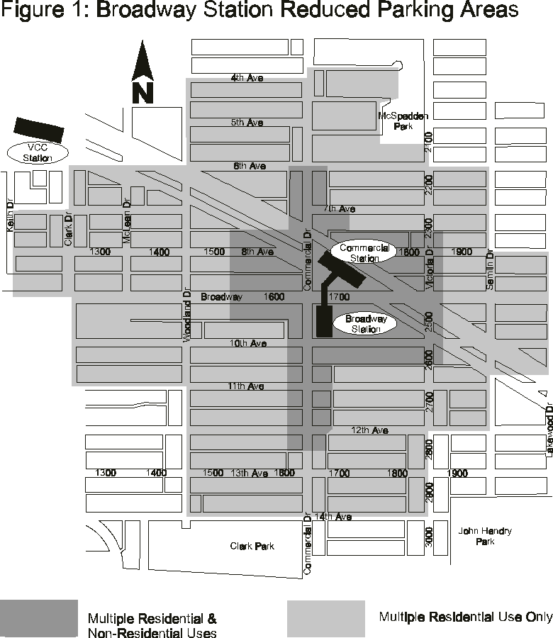
Except for office, retail, and service uses, whereby parking requirements are in large part for employees (i.e., commuters), most uses should not be subject to a maximum permitted parking standard. This will allow greater flexibility for development and enable adequate parking where needed for project feasibility and protection of the neighbourhood against overspill.
Standards in the Parking By-law for loading, bicycles, and passenger spaces should remain unchanged. Finally, provisions in the By-law for relaxation and mixed-use reduction should be available to avoid hardship and foster more efficient development.
APPENDIX D
Kensington/Cedar Cottage Vision Directions
Directions Relevant to the Broadway & Commercial Area
Dir.# |
Direction |
% Support |
City
|
Shopping Area and Transit Hub |
|||
6.1 |
Broadway & Commercial area should be:
|
83% |
_ |
|
6.3 |
It should be easier and safer to cross the streets, and traffic should move more slowly through Broadway & Commercial with:
|
79% |
_ |
6.4 |
Broadway & Commercial should have a better image, be safer and more comfortable for shoppers and transit users and include:
|
84% |
_ |
6.5 |
Small local shops and services should line the sidewalk on both sides of the street, especially along Commercial Dr (instead of parking lots in front of buildings). |
82% |
retail study guidelines and BIA |
6.6 |
Redevelopment of the northeast comer of Broadway & Commercial should be used as an opportunity to achieve Vision directions. (e.g. a community plaza). |
73% |
_ |
6.7 |
Short-term safety improvements should be made to the Safeway site, (e.g. better lighting. security in parking lot). Redevelopment (if any), of the site should be used as an opportunity to contribute to the Vision. |
80% |
upgraded in 2000 |
Other Ways to Strengthen Shopping Areas Such as Broadway & Commercial |
|||
9.1 |
Parking for shoppers should be provided by:
|
83% |
_ under guideway |
9.2 |
Business associations and Improvement Areas should be encouraged to promote shopping and organize activities (e.g. fairs, markets, community days, promotions...). |
72% |
being pursued |
9.3 |
There should not be any additional internal shopping malls or big box stores in this shopping area or close enough to threaten it. |
68% |
_ |
|
Mixed Use Development | |||
10.1 |
The design of mixed-use development should be improved through:
|
84% |
guidelines
|
Public Transit | |||
15.1 |
The new Broadway transit line should benefit the neighbourhood through:
|
80% |
_ |
15.2 |
More and better bus shelters with benches, schedules, maps and lighting should be provided on all routes. |
82% |
Translink |
15.3 |
Bus bulges should be built to give buses higher priority in traffic. |
71% |
_ |
15.4 |
There should be more local input in transit decisions to help ensure changes to transit benefit the neighbourhood. |
84% |
_ |
Bike Routes and Greenways | |||
17.1 |
Bikeways/greenways should link shopping areas, community centres. schools with safe crossings at major streets and an extension of Grace MacInnis Park north to the Broadway & Commercial area. |
71% |
tradeoff with retail
|
17.3 |
A bike lane should be considered for Commercial Drive as part of the city-wide network. |
62% |
not feasible |
Greening, Parks, Public Places | |||
24.1 |
More greening in public spaces to improve community appearance. |
85% |
_ street tree
|
24.6 |
Preserve the Grandview Cut as a public amenity/green zone (while recognizing its rail and possible transit role) and link it to the community at Broadway & Commercial. |
78% |
SkyTrain |
24.7 |
Protect views to the mountains and water from public places (e.g. Kensington and Clark Parks, Commercial Drive...). |
87% |
N.A. |
Cleanliness, Upkeep, and Building Quality |
|||
26.1 |
There should be a higher standard of property maintenance and cleanliness of private and public property through:
|
91% |
owners
|
26.2 |
New buildings should be of higher quality so that they last longer and can be more easily maintained |
88% |
guidelines |