POLICY REPORT
URBAN STRUCTURE
Date: March 19, 2001
Author/Local: Ian Smith/7846
RTS No. 01924
CC File No. 8203
T&T: March 27, 2001
TO: |
Standing Committee on Transportation and Traffic |
FROM: |
Director of Current Planning and the General Manager of Engineering Services, in consultation with General Manager of the Park Board and the Director of Real Estate Services |
SUBJECT: |
False Creek Flats - Urban Structure Plan |
RECOMMENDATION
A. THAT the False Creek Flats Structure Plan contained in Appendix A, including phasing, be approved in principle.
B. THAT the Subdivision Approving Officer be advised of Council's approval of the False Creek Flats Structure Plan, so that subdivision decisions may reflect and further the implementation of the plan.
C. THAT the Director of Current Planning be instructed to make application to amend the Zoning and Development By-law generally in accordance with Appendix B;
FURTHER THAT the Director of Legal Services be instructed to prepare the necessary by-law;
AND FURTHER THAT the draft by-law contained in Appendix B be referred to a Public Hearing along with the recommendation of the Director of Current Planning to approve the by-law.
D. THAT Council instruct staff to report back on the timing and cost of a study to analyze short-term and long-term rail needs in the False Creek Flats with regard to the City and Port.
E. THAT Council instruct staff to report back on the timing and cost of a transportation review of the impacts of the proposed False Creek Flats Structure Plan on surrounding areas and beyond.
GENERAL MANAGERS' COMMENTS
The General Manager of Community Services and the General Manager of Engineering Services RECOMMEND approval of A through E above.
COUNCIL POLICY
· In June 1996, Council adopted the False Creek Flats Preliminary Concept Plan which set policy directions for the Flats and identified suitable locations for high-technology and commercial uses while preserving some land for city serving and transportation related industrial uses.
PURPOSE
The purpose of this report is to provide a detailed overview of the False Creek Flats urban Structure Plan, attached as Appendix A. As well, this report proposes amendments to the I-3 zoning in the False Creek Flats.
A companion report entitled "False Creek Flats: Area Specific Development Cost Levy" proposes an area-specific development cost levy and spending strategy for this part of the city. (NOTE FROM CLERK: Dealt with at the April 12, 2001, meeting of the City Services and Budgets Committee)
BACKGROUND
The approximately 300 acres of land that make up the False Creek Flats currently consist of low-intensity development, and, for the most part, are defined by rail and industrial uses and vacant lots. However, redevelopment has begun in this area, spurred by the retreat of rail and heavy industry and the creation of the I-2 and I-3 Districts. Interest in the Flats has grown quickly, thus reinforcing the emergence of part of this area as a high-tech employment centre.
In recent years several initiatives have helped give shape to what will be the ultimate form of the Flats. The Industrial Lands Strategy of 1995 created policy that supported the retention of city-serving industrial, transportation, and service uses in the Flats. In 1996, theFalse Creek Flats Preliminary Concept Plan reaffirmed the industrial nature of the Flats but also identified new directions in high-technology, supporting commercial and other uses.
In 1998 staff entered into a collaborative planning process with Finning International, to learn together about urban models of high-tech industry. This process resulted in a CD-1 rezoning for the 26-acre Finning property to allow development of a high-tech campus. As well, this process resulted in the publication of Planning's discussion paper "High-Tech Industry in the Urban Context", which tackled such topics as necessary supporting uses, transportation requirements, and preferred built-form and amenities.
The creation of the I-3 District in 1999 and its application to approximately 100 acres in the western and southern portions of the Flats furthered the transition in the Flats toward more intensive high-technology uses.
While past work on structuring the Flats (i.e. the 1996 Preliminary Concept Plan and its 1999 revisions), produced conceptual road, infrastructure, and development patterning, this work was more reactive in nature than comprehensive. The opportunity to do more planning and structuring arose in the spring of 2000, after CN Rail, the largest landholder in the Flats, aired plans to rationalize rail operations on a portion of their site. CN subsequently entered into a process with staff to assess subdivision plans for their central yard. The potential subdivision of this significant 40-acre parcel presented a unique opportunity as well as an absolute imperative to begin shaping the area and addressing future planning initiatives in the Flats. In May 2000, Council endorsed a work program for staff to develop a comprehensive Structure Plan for the Flats, and in particular, provide planning direction for CN Rail 's Terminal Avenue yard and for the City-owned properties at Main and Terminal.
DISCUSSION
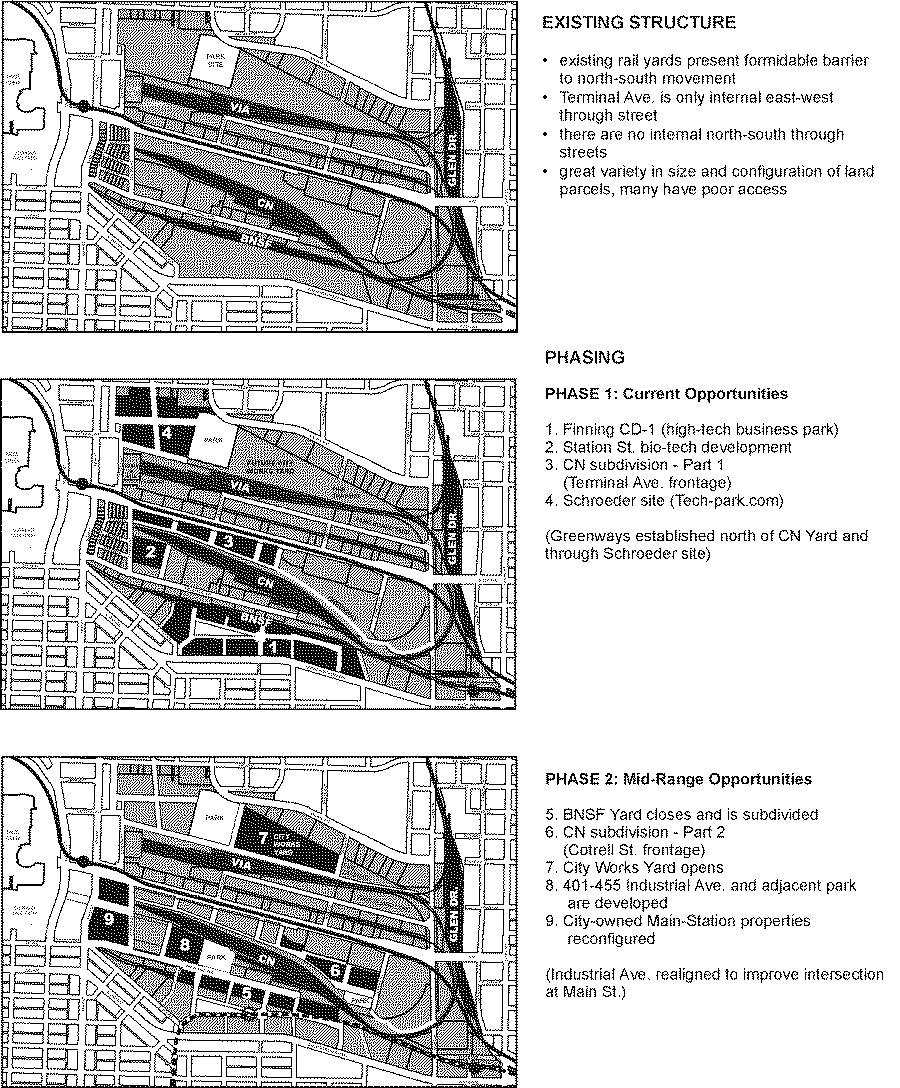
Several planning challenges currently exist in the Flats. The large expanses of land defined by rail and related operations make the area conspicuous and removed from the established urban fabric of surrounding neighbourhoods. As well, the lack of north-south connections, poor linkages through the area, and limited internal road structure further create the sense that the Flats is a barrier rather than an integrated part of the city.
To address these challenges, staff analyzed the Flats and its environs in a comprehensive way. Several workshops were held in which all relevant City departments and an urban design and planning consultant (Civitas) worked together to develop an urban Structure Plan. This plan proposes a specific patterning of roads, lanes, parks, greenways, and pedestrianconnections with associated utilities, which over time will re-unite the False Creek Flats with the fabric of the City. In terms of policy, the plan accounts for the needs of both city-serving industrial and emerging high-tech uses.
The following section provides the principles which informed the Plan and describes the Structure Plan in more detail (an illustrated version can be found in Appendix A).
1. Structure Plan
The following urban design principles guided the creation of the Structure Plan:
· Develop a more urban structure to reintegrate the Flats into the city, recognizing this area's potential as a major centre for jobs and an important piece of the False Creek and east downtown communities.
· Connect and link the Flats to surrounding areas by extending the existing street grid
· create a fine grain of public streets and rights-of-way to facilitate movement through the Flats, but with adequate block sizes to accommodate city-serving industrial needs.
· Maintain a clear distinction between the public and private realms; keep roadways within dedicated streets and have public pedestrian rights-of-way across large sites.
· Provide a range of street types, ranging from wide major boulevards with centre medians to narrow pedestrian mews.
· Provide new park land in key locations, preferably surrounded by streets and with adequate land area to accommodate sports and other recreational activities.
· Provide a major Greenway route through the Flats consistent with the city-wide Greenways Plan; exploit other opportunities for minor Greenway connections that increase accessibility for pedestrians and cyclists.
· Facilitate transit corridors and connections through the Flats, and station locations to adequately serve the worker population.
Urban Block Structure and Grid
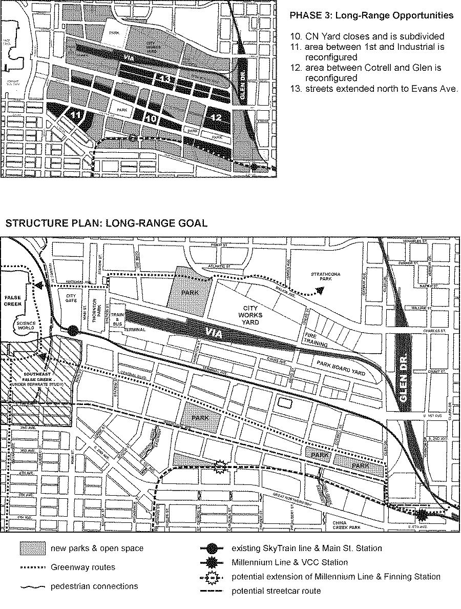
To support the vision of the Flats as an urban industrial area, a network of streets, lanes, and public ways is proposed which will allow an intensity of pedestrian and vehicular access to make the area a vital, well integrated piece of the city. The Structure Plan is based on dedicated streets to create a public realm that truly is public, and which readily accommodates the changing needs of the area and its infrastructure. Block size will be at a scale common to the rest of the city, thus reflecting the surrounding areas, and as such will be sufficiently fine-grained to function at a pedestrian scale, yet also large enough to accommodate high-tech and city-serving industrial uses.
Integration and North-South Connections
The Structure Plan recognizes and builds on opportunities for desired connections in and through the Flats and for integration between adjacent development areas and existing street patterns. Where possible the grid is extended to provide visual and/or physical access to neighbouring areas. The plan creates opportunities to establish key north-south connections, most importantly the extension of Glen Drive, and also Thornton Street, which in the future may connect Malkin Avenue through to Great Northern Way. At the southwest corner of the Flats, Scotia and Station Streets are extended to tie into the Mount Pleasant neighbourhood.
East-West Connections
Two east-west boulevards are major organizing elements in the proposed Structure Plan. Industrial Avenue will be expanded and enhanced to potentially accommodate the Downtown streetcar, a central boulevard, and a bikeway, as well as vehicular and pedestrian traffic. A reconfiguration at Main Street will allow Industrial to connect with First Avenue in Southeast False Creek. Between Terminal and Industrial Avenues a second east-west boulevard is proposed across the CN lands. This boulevard will accommodate the Central Valley Greenway. It may also accommodate surface storm water features and daylighting, recognizing the history of this area prior to filling.
Park Blocks and Greenway Connections
The two major east-west boulevards will enclose a series of urban park blocks. This spine of parks will "green" the Flats; serve the recreational needs of the surrounding working population; provide a focus for development; and enhance the value of surrounding properties. Parks located at the western and eastern ends of the central spine will serve as focal points in the Flats, and will be bounded by public streets and/or bikeway/greenways to ensure clarity and accessibility as public spaces. The total park space in the Structure Plan is currently 6 acres, but may be expanded further.
2. Phasing
The following principles informed the proposed phasing of the Plan:
· Accommodate the rail yards within the plan for as long as they are needed to serve port and city needs, but consider the possibility of them leaving. In the shorter term, look for opportunities for streets to cross where feasible.
· Secure the corridor for passenger rail and the train/bus terminal to remain in the long term.
· When subdivision plans come forward, seek road dedications consistent with the Structure Plan; consider purchasing missing pieces that are not forthcoming through the redevelopment process.
· Secure the major Greenway route as soon as possible, in an interim alignment if need be.
· time development of parks with growth in worker population
To achieve this vision for the Flats, staff have developed a series of phases through which the plan may evolve. These phases are not timed in discrete years, rather they are event-based, flexible and responsive. Events that will spur implementation of the plan may include: redevelopment of the Finning lands, the Schroeder property, and CN's subdivided parcels on Terminal Avenue; development of the City-owned blocks at Main and Terminal; construction of the VCC Skytrain Station; the removal of BNSF's southern yard; and the possibility of further rationalization of CN's trackage.
The implementation of phases that are tied to the potential relocation of BNSF's and CN's rail will be at the discretion of these companies - their track and yards shall remain in the current locations until they can satisfactorily meet their operational needs elsewhere. As well, it should be noted that the Amtrak and VIA rail track terminating at Pacific Central Station is on an operating rail right-of-way, and staff anticipate that these passenger operations will remain in place.
There are two further pieces of work that should be completed following the adoption of the Structure Plan. First, to more fully understand the implications of rail rationalization on goods movement in the City at large, and in particular on the Port, a study is recommended. Although the City will not seek to impact the timing and/or plans for CN's and BNSF's rail and yards, it is important to understand the implications of the emerging land-use policies contained in the Structure Plan. The parameters of this study, as well as timing and cost, will be reported back to Council.
Second, while each proposed development in the Flats will undertake a transportation study to understand the consequences of that development on the surrounding area, a broader transportation study has never been done. To understand the overall implications of the I-3 zoning and consequent change in worker population and trip demand on the Flats and surrounding area, it is recommended that a transportation study be undertaken and that staff report back on the timing and terms of reference.
3. Costs of Implementation
In terms of financing the benefits and improvements proposed in this plan, staff conclude that some parts of this plan can be accomplished through requirements for subdivision and as part of the development permit process. However, other parts will be achieved based on funds from a combination of the proposed area-specific development cost levy (DCL) for the Flats (see companion report), and on-going capital plan contributions over the years. While funds from the city-wide DCL may be available, allocating these funds will be a separate process that involves assessing opportunities and overall city priorities. The City has thus far taken an active role and will continue to be a partner in the change and growth in the Flats, and in implementing the Structure Plan. Staff will monitor, learn, and re-assess based on our experiences in this area.
4. Adjustment to I-3 Zoning in the Flats
Since the implementation of the I-3 zone, some areas of challenge have been identified by staff with regard to the False Creek Flats. More specifically, the allowable density, and lack of design control within the False Creek Flats I-3 need to be revisited, given the large sites. Outright developments in this area have not benefited from controls or design guidelines that are part of site-by-site `rezonings in the Grandview/Boundary industrial and high-tech area. Staff have particular concerns over the density currently specified as it is realized over the gross area of a large site and expressed on the net area of smaller sites. After road dedication, the FSR achieved can be much higher than the maximum permitted 3.0.
The recommended solution is to create conditional aspects to the density permitted in this zoning so that more design control can be exercised and public realm requirements can be secured through the development approval process. An amendment to the False Creek Flats I-3 zoning - thereby creating a new I-3F zone in the Flats - which establishes an outright allocation of up to 1.0 FSR and a conditional component between 1.0 and 3.0 FSR would accomplish this. The draft amendments set out in Appendix B create a new I-3F District Schedule for the False Creek Flats while leaving the I-3 District Schedule unchanged as it applies to other areas. Staff recommend that the draft amendments in Appendix B be referred to public hearing at this time.
In conjunction with the above amendment, siting and massing guidelines akin to those prepared for the Grandview/Boundary area will be prepared for Council's consideration at public hearing to assist both staff and applicants.
5. Adjustment to I-2 Zoning in the Flats
Council may also want to consider revising the I-2 zoned portion of the False Creek Flats. When I-2 was created it was meant to accommodate both low and high-tech industries. However, the subsequent creation of high-tech zoning for over 105-acres of the Flats (approximately 80 acres of I-3, and 25 acres in Finning's CD-1) calls into question the need to continue including high-tech use in the Flats I-2 area.
The consultant's report on an area-specific DCL indicates that absorption of technology space in the Flats would be unlikely to exceed over 200,000 square feet per year, suggesting that the redevelopment of the Flats will occur over a 20-year period. Considering this, it probably makes sense to focus high-tech into an area that is appropriately zoned with a high-degree of transit accessibility. At the same time, to preserve the existing supply of I-2 land in the Flats for City-serving and transportation, the staff team will investigate a new zoning of the Flats I-2 area. This will be followed up as part of the on-going work in the False Creek Flats.
6. Public Process
The Flats Structure Plan has informed discussions with property owners since its completion in early January. In particular, it has informed those discussions where elements of the Structure Plan would be realized through dedications or acquisitions. As well, the draft plan was presented to property owners who attended the public meeting to discuss the proposed area-specific DCL. The structuring of the south-western portion of the Flats received thorough public input during the Finning rezoning process.
CONCLUSION
As the role of the Flats within the city evolves, so too must the urban structure which serves and defines it. In the urban Structure Plan presented in this report, staff have established a strong vision and direction for the Flats that remains malleable and responsive to change. The plan will serve the needs of development and guide planning and engineering work, not only on impending decisions, but well into the future.
* * * * *
APPENDIX A
Page 1 of 3
False Creek Flats Structure Plan
What is a Structure Plan?
This is a large-scale urban design plan which shows how the streets, open spaces and other urban elements may be formed in the future. Its purpose is to guide subdivision and redevelopment patterns in the False Creek Flats. At the scale of this plan, building massing and detailed street design are not addressed. The current regulations governing land use and development are assumed and no changes to them are proposed here. It is an incremental plan with a phasing strategy that accommodates existing land uses while responding to many opportunities for change that will occur gradually over a very long period of time, beginning today but extending to 50 years or so in the future. It is a comprehensive plan in that it allows for many uncertainties and contingencies while striving to achieve an overall structure for the area.
Urban Design Principles
· develop a more urban structure to reintegrate the Flats into the city, recognizing this area's potential as a major centre for jobs and an important piece of the False Creek and east downtown communities
· connect and link the Flats to surrounding areas by extending the existing street grid
· create a fine grain of public streets and rights-of-way to facilitate movement through the Flats, but with adequate block sizes to accommodate city-serving industrial needs
· maintain a clear distinction between the public and private realms; keep roadways within dedicated streets and have public pedestrian rights-of-way across large sites
· provide a range of street types, ranging from wide major boulevards with centre medians to narrow pedestrian mews
· provide new park land in key locations, preferably surrounded by streets and with adequate land area to accommodate sports and other recreational activities
· provide a major Greenway route through the Flats consistent with the city-wide Greenways Plan; exploit other opportunities for minor Greenway connections that increase accessibility for pedestrians and cyclists
· facilitate transit corridors and connections through the Flats, and station locations to adequately serve the worker population
Phasing Principles
· accommodate the rail yards within the plans for as long as they are needed to serve port and city needs, but consider the possibility of them leaving. In the shorter term, look for opportunities for streets to cross where feasible.
· secure the corridor for passenger rail and the train/bus terminal to remain in the long term
· when subdivision plans come forward, seek road dedications consistent with the Structure Plan; consider purchasing missing pieces that are not forthcoming in the redevelopment processes
· secure the major Greenway route as soon as possible, in an interim alignment if need be
· time development of parks with growth in worker population
APPENDIX A
Page 2 of 3
APPENDIX A
Page 3 of 3
APPENDIX B
Page 1 of 1
Draft Amendments to the Flats I-3 District Schedule
Because of density, design control, and infrastructure concerns, the following draft amendments to the I-3 District Schedule are recommended (changes are underlined), thereby creating a new I-3F District Schedule to replace the I-3 District Schedule in the False Creek Flats.
1 Intent
The intent of this schedule is to permit high technology industry, and related industry with a significant amount of research and development industry. It is also the intent to permit light industrial uses that are generally compatible with high-technology development, one another, and with adjoining residential or commercial districts.
4.7 Floor Space Ratio
4.7.1 The floor space ratio shall not exceed 1.00. The Development Permit Board may permit an increase in this maximum floor space ratio to any figure up to and including 3.00 provided that it first considers:
a) the intent of this schedule, all applicable policies and guidelines adopted by Council, and the relationship of the development to any nearby residential uses;
b) the height, bulk, location, and overall design of the building and its effect on the site, surrounding buildings, and streets;
c) the provision of roads, bikes, and pedestrian connections as outlined in Council's adopted plans and policies
And further any increase is subject to the following:
The existing conditions listed as (a)-(d) must be re-lettered (d)-(g)