

|
|
Supports Item No. 2
T&T Committee Agenda
May 2, 2000POLICY REPORT
URBAN STRUCTURE
Date: April 20, 2000
Author/Local: Ian Smith/7846
RTS No. 01459CC File No. 8203
T&T: May 2, 2000
TO:
Standing Committee on Transportation and Traffic
FROM:
Director of Current Planning in consultation with the General Manager of Engineering Services and the Manager of Real Estate Services
SUBJECT:
False Creek Flats Industrial Area: Current Initiatives, Staffing and Work Program
RECOMMENDATION
A. THAT the work program to address current initiatives in the False Creek Flats be endorsed.
B. THAT the resources identified to undertake the work program be approved, at a total cost of $140,000, on a partial cost-recovery basis which includes a contribution from Canadian National of $70,000 (to plan and develop zoning for their property and to be applied against any rezoning fees which may be incurred) and includes $70,000 in matching funds from the City, of which $40,000 would be from the Contingency Reserve and $30,000 from the Property Endowment Fund (to also plan and develop zoning for City properties and to be applied against any rezoning fees which may be incurred).
GENERAL MANAGER’S COMMENTS
The General Manager of Community Services RECOMMENDS approval of the foregoing.
COUNCIL POLICY
· In June 1996 Council approved the False Creek Flats Preliminary Concept Plan.
· On July 6, 1999 Council approved the I-3 High Technology District, rezoning 106 acres in the False Creek Flats.
· On July 20, 1999 Council directed staff to report back on an area-specific Development Cost Levy (DCL) for the False Creek Flats, including an economic analysis of the financial impact of a DCL, and to also report on policy issues related to park and childcare requirements in industrial lands.
· On September 21, 1999 Council approved a rezoning of the 26-acre Finning property from I-3 to CD-1 to facilitate the development of Great Northern Technology Park.PURPOSE
This report proposes a program and funding to complete a number of critical planning and engineering work items for the False Creek Flats, and to develop an urban structure plan to guide future development in the area.
BACKGROUND
The False Creek Flats Preliminary Concept Plan, approved in 1996, provided preliminary policy direction for planning initiatives in the False Creek Flats Industrial Area. Further work to complete the plan was not a priority at the time and, after adoption of the preliminary plan, the work stopped.
Since 1996, several initiatives have affected the Flats. The I-3 High Technology District was created in 1999 to facilitate the location of information technology and other high-tech land uses on about 100 acres in the western and southern portions of the Flats. A further CD-1 rezoning was approved for the 26-acre Finning property on Great Northern Way to permit development of a high-tech campus. Both of these initiatives were consistent with policies set forth in the preliminary concept plan.
The work completed for Finning addressed a number of planning and engineering issues within and around the Finning site, but it did not answer all of the questions regarding the future urban structure for the area. Even though the Finning team has been disbanded, work does continue on the proposed area-specific DCL for the Flats with a report expected sometime this year, depending on work and staff allocations.
In the last few months, following the adoption of the I-3 zoning, interest in the Flats has grown and two significant landowners (Schroeder Properties Ltd. and Canadian National Railway) have come forward with plans to redevelop their properties. As these are large sites, the ultimate pattern of infrastructure, roads and development will have a lasting impact on the entire area.
DISCUSSION
During the preparation of the I-3 District Schedule it became evident that increasing building and worker density with high tech would require a comprehensive look at infrastructure. The worker population is expected to grow from 1,000 employed in conventional industries to 20,000 or more employed in high tech. As such, within 10 to 20 years, the area could rival the Downtown Core and Central Broadway as an employment centre. With such growth, a structure of streets and utilities needs to be put together with an urban design framework that will serve the area for the next 50 years. This structure will serve not just the Flats Industrial Area but adjacent areas as well, especially the undeveloped areas of Southeast False Creek and the Thornton Park Neighbourhood.
An urban structure plan will address much more than just utility infrastructure. It is a combination of streets, pedestrian ways, parks, greenways and utilities. It also covers the basic provision and location of public facilities. The plan will entail urban design which will conceptualize a long-term vision for the built form of the area, having regard for adjacencies, view sheds and programmatic needs. Moreover, an urban structure plan will form a comprehensive framework to guide planning, engineering and design for the near and far future.
A map in Appendix A illustrates recent initiatives in the Flats that present both a need and an opportunity to address the future structure of the area. Following is a description of those initiatives and of the urban structure elements to be addressed in the proposed work program.
Schroeder Properties – The City has had pre-application discussions with Schroeder Properties and their consultants regarding a 17-acre parcel of land in the northwest corner of the Flats. They are proposing a development under I-3 zoning which add 2,000,000 square feet of high-tech work space. With this much floor area being proposed, there are significant issues to address related to street alignments, service upgrades and impact on surrounding lands. In reviewing the proposal, both staff and the Urban Design Panel have identified the need for more analysis of the overall objectives for the future structure of the Flats.
CN Lands – Canadian National Railway is the largest landowner in the Flats. It is currently in the process of rationalizing its rail operations. A number of parcels of land along Evans Avenue have already been sold to new owners who continue with I-2–type warehousing andfreight-forwarding activities. In the Main Yard, between Terminal and Industrial avenues, the proposal is to reduce rail operations into a narrow width of track and free up the remaining property for sale for redevelopment. This will require subdivision of a 50-acre parcel — the largest parcel of land in the Flats. Subdivision of such a large and critical piece of land poses many questions. The current opportunity to plan and secure new streets and public open space or park land will play a large role in shaping the future structure of the Flats. CN has submitted a preliminary subdivision plan which, with current staffing, may take over one year to process and may not optimize the opportunities presented.
Terminal Avenue – The 1996 preliminary concept plan recognized that Terminal Avenue had a more commercial personality that other areas in the Flats. It suggested that it serve the day-to-day needs of the local worker population, and that recreational and entertainment uses be considered. A final decision on the future was not made, including zoning changes. In light of CN’s interest in selling their Terminal Avenue frontage, the ultimate use for the street need to be defined. Terminal is currently zoned I-3 to the west of Thornton Street and I-2 to the east. A new urban design vision for the street and a new zoning are required to knit this street back into the city fabric and to accommodate commercial needs of the adjacent high-tech area.
City-Owned Lands – The City is the second largest landowner in the Flats. Major holdings south of Malkin Avenue are planned for park land, works yards and fire training facilities. Other holdings, such as the properties between Main and Station streets, are not planned for major civic purposes and may soon become available for private redevelopment. The Main-Station parcels, in particular, are identified in the preliminary concept plan as part of the Thornton Park Neighbourhood. While a direction was established to redevelop this area’s mixed uses, including high tech, commercial and possibly live-work, this was not concluded nor was a zoning recommended. The area is to serve as a transition between the high-tech and light industrial uses to the east and the residential, commercial and park uses of Southeast False Creek to the west. All of these City-owned properties have a critical role in the creation of a new urban structure for the Flats.
Street Network – With much of its land area devoted to rail yards, the Flats has never developed an effective street network, particularly for north-south circulation. Streets are the primary element of an urban structure plan and a major challenge for the Flats is the highly varied land parcelization and the irregular sequence of redevelopment that is unfolding, noting that newly created street rights-of-way will outlive all current proposals.
Utility Infrastructure – Existing infrastructure in the Flats has been geared to serving low-density rail and warehousing activities. High-tech uses at much higher densities will require upgrading sewers, water and other utilities. While utility upgrades have been planned for the Finning site, work needs to be completed for the remainder of the Flats.
Greenway and Park Linkages – The 1995 Greenways Plan identifies a major route through the False Creek Flats called the BC Parkway. This route is to link with a regional system extending into Burnaby and beyond. The route has been well accommodated in the current planning for SkyTrain to the east of Commercial Drive and similar consideration is needed on the portion through the Flats, as it will provide a critical link to the False Creek Waterfront and to the Downtown. Subdivision of CN’s 50-acre parcel has long been seen as a prime opportunity to secure open space and a possible right-of-way for the BC Parkway. A local greenway route is also proposed across the north edge of the Flats which would link the Adanac Bikeway, Strathcona Park, Thornton Park and the False Creek Waterfront. This link extends through the future Malkin Avenue park and the Tech-park.com development proposed for the Schroeder Property. A system of linked parks is critical to the future of the Flats to equally serve the large worker population, the surrounding communities and the city as a whole.
Other Public Facilities – In addition to parks and greenways, childcare and public art are two more areas which are typically provided in high-employment office districts. How these might be provided in the Flats is also to be determined.
Area-Specific Development Cost Levy (DCL) – An economic consultant is currently analysing the financial impact of DCLs on development in the Flats, as requested by Council in July 1999. A public review of the DCL proposal is also called for, as well as a policy review by staff of park and childcare provisions in industrial areas. The DCL work is integral to the urban structure review, as DCLs are expected to be a major source of revenue to build the new infrastructure. Part of the work will entail developing a distribution plan for the anticipated DCL money. Timely implementation of the DCL strategy is critical to ensure that infrastructure work is funded and proceeds concurrently with development.
Staff Management and Resources
The initiatives underway in the Flats create additional staffing demands in Planning and Engineering, especially since the rezoning work program for Finning has drawn to a close. While subdivision and development permit fees will be generated in the future by some of the projects, this will not fund the critical up-front policy and infrastructure planning work.
Instead a public-private partnership is proposed with funds provided by Canadian National and matching funds proposed for the City. This will permit a dedicated team to address all of the False Creek Flats planning initiatives in a comprehensive manner. The work is expected to be completed within a one-year period. This team will be managed within the Central Area Planning Branch by the Senior Planner also in charge of the Southeast False Creek planning effort. The Senior Planner will report to the Major Projects Steering Committee consistent with established practices for large inner-city projects.
Time lines for the various components of the work program are shown in Appendix B. Priority will be given to addressing the needs of the CN Lands and completing the implementation of the Area-Specific DCL.
Staffing Requirements
Planner II (12 months) To co-ordinate urban structure, land use and zoning issues and infrastructure financing in developing a comprehensive urban structure plan for the False Creek Flats.
Civil Engineer I (12 months) To provide required expertise for roads and other infrastructure necessary to serve more intensive land uses in the False Creek Flats
CostsStaff Costs:
Planner II $67,500 (12 months)
Civil Engineer I $63,000 (12 months)Other Costs:
Public consultation $3,000
Computers $3,000
Overtime $3,500Total Costs: $140,000
Consultancy (Urban Design) $10,000 (from Planning Department Consultant Budget – already allocated)
Funding is proposed as a public-private partnership with CN assuming half the costs (assessed at $70,000) to be applied against rezoning fees for reconsideration of land uses on their Terminal Avenue property. The City would match CN’s contribution with another $70,000. Given that the future of the City-owned lands at Main and Terminal will be considered in the work program, the Manager of Real Estate is prepared to contribute $30,000 from the Property Endowment Fund, also to be applied against rezoning fees for these properties. The remaining $40,000 would be allocated from the Contingency Reserve in this year’s budget. Another $10,000 of City money is already committed from the Planning Department’s Consultant Budget for an urban design study to be undertaken as part of the process.
Work generated by the private properties will be more than fully cost recovered. CN is prepared to contribute these funds to secure a dedicated team and a priority on the subdivision of the parcels on Terminal avenue.
CONCLUSION
This work program will allow for the completion of work started with the 1996 False Creek Flats Preliminary Concept Plan. Approval of the program is recommended so that numerous planning initiatives underway in the False Creek Flats can be handled comprehensively by a dedicated team of Planning and Engineering staff.
* * * * *

APPENDIX A
Page 1 of 1
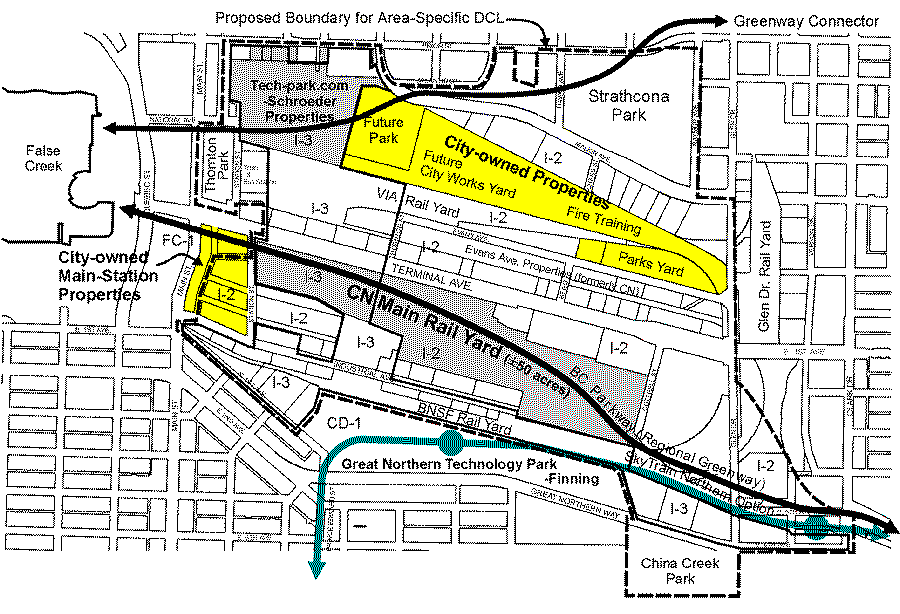 Current Planning Initiatives in the False Creek Flats
APPENDIX B
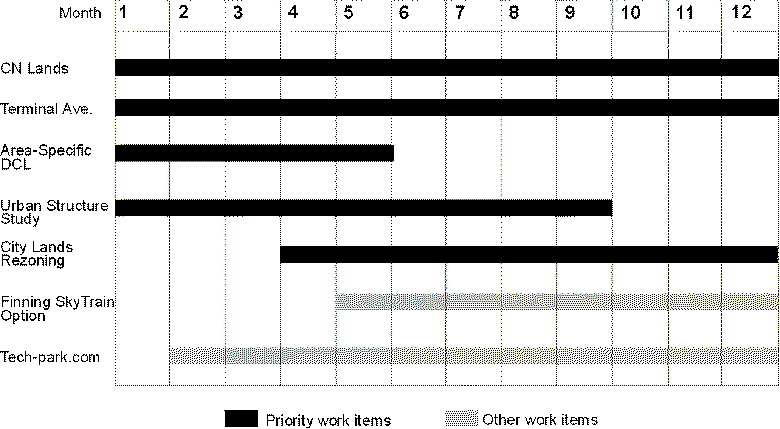 Work Program for Dedicated Flats Team
Page 1 of 1
![[City Homepage]](/graphics/footnava.gif)
|
![[Get In Touch]](/graphics/footnavb.gif)
|

|

|

|
(c) 1998 City of Vancouver