|
|
POLICY REPORT
DEVELOPMENT AND BUILDING
Date: January 18, 2000
Author/Local: MKemble/7702
RTS No. 01012
CC File No. 5305Council: February 1, 2000
TO:
Vancouver City Council
FROM:
Director of Current Planning
SUBJECT:
Text Amendment: Coal Harbour Official Development Plan (CHODP) - Jervis Street-end View Corridor
RECOMMENDATION
THAT the application by James Cheng Architects to amend the Coal Harbour Official Development Plan (CHODP) with respect to the Jervis Street-end view corridor setback requirements affecting the site at 301 Jervis Street and other development sites on the east side of Jervis Street, to permit buildings up to 10.7 m (35 ft.) in height to encroach within the view corridor be referred to a Public Hearing, together with:
(i) draft amendments to the Coal Harbour Official Development Plan (CHODP) generally as presented in Appendix A; and
(ii) the recommendation of the Director of Current Planning to approve subject to alternative ODP amendments as presented in Appendix B, and draft consequential CD-1 guideline amendments generally as presented in Appendix C.
FURTHER THAT the Director of Legal Services be instructed to prepare the necessary alternative by-laws for consideration at the Public Hearing.
GENERAL MANAGER’S COMMENTS
The General Manager of Community Services RECOMMENDS approval of the foregoing.
COUNCIL POLICY
Relevant Council policies include:
· The Coal Harbour Policy Statement adopted February 1990, which called for five degree view preservation cones to be established at each side of the ends of north-south streets (from the CWD/DD zoning boundary).
· Coal Harbour Official Development Plan, adopted November 6, 1990.
· Marina Neighbourhood Sub-Area 1B (301 Jervis Street) CD-1 Zoning and Guidelines, adopted November 1996.
· Harbour Green Neighbourhood (501 Bute Street) CD-1 Zoning and Guidelines, adopted November 1996.
PURPOSE AND SUMMARY
This report assesses an application to amend the Coal Harbour Official Development Plan (hereinafter referred to as ODP) with respect to street-end view corridor setback requirements on Jervis Street. Proposed are amendments that would:
· allow, for improved urban design, a minor extension of townhouses up to 10.7 m (35 ft.) in height fronting on to Harbour Green Park, by permitting these low level encroachments into the street-end view corridor setback; and
· correct several inconsistencies between the ODP text and illustrative diagrams of designated viewpoints for the street-end view corridor on Jervis Street.Two options are presented for implementing these ODP amendments:
· The applicant’s proposal (see Appendix A) would exempt lower buildings from the existing ODP view corridor setbacks, thus permitting the full extent of two-storey townhouses along the park edge, to within about 1.5 m (5 ft.) of the Jervis Street right-of-way, with unequal setbacks provided each side of the right-of-way.
· The staff’s proposal (see Appendix B) would provide reduced view corridor setbacks that would permit the extension of townhouses to within 7 m (23 ft.) of the Jervis Street right-of-way, with equal setbacks provided each side of the right-of-way.While staff are supportive of some relaxation of the view corridor, the second option is recommended because it is more equitable to both properties on either side of Jervis Street, and is more consistent with policy approved for other nearby street-ends that seeks to maintain public views of water and mountains.
DISCUSSION
Street-end View Policy: The preservation of northerly street-end views of water and mountains is one of the most important public objectives incorporated into planning policy, design guidelines and site-specific CD-1 zones approved for Coal Harbour. There are specific references contained in the Coal Harbour Policy Statement, the ODP and CD-1 Guidelines for three neighbourhood sub-areas. While these five degree view corridors were originally mandated at the Policy Statement stage in 1990, the approved policy (see Appendix E) did allow for minor relaxations within the following guidelines:
· the view reduction is essential to the overall quality of the waterfront development; and/or
· the view reduction is not detrimental to the overall quality of the existing street-end view from the downtown; and/or
· the physical design of the portion of the waterfront development which causes the view reduction is of quality and will enhance the physical character of the immediate surroundings; and/or
· an alternative access to view waterfront activities, Stanley Park, Burrard Inlet and/or the North Shore mountains is provided as a trade-off at a location in the vicinity of a particular street end and is easily accessible to the public from downtown.At the ODP approval in 1990, minor adjustments were made to several street-end view corridors at Cardero, Nicola, Bute and Thurlow Streets consistent with the above guidelines. Of the four northerly street-end views protected within the westerly Marina Neighbourhood Sub-Area - Cardero, Nicola, Broughton, and Jervis Streets - the particular street-end view having the most impact on nearby development sites is the Jervis Street view (see ODP figures attached as Appendix F). This is due to the atypical location of the viewpoints on the south side of Hastings Street about two city blocks from the water’s edge, or about twice the distance of all the other three street-end viewpoints in this neighbourhood. This results in a maximum view corridor setback at the northerly edge of development on Jervis Street of about 15 m (50 ft.). For comparison, maximum view corridor setbacks on Cardero, Nicola and Broughton Streets are about 7.6 m (25 ft.).
A recent development application for 301 Jervis Street (DE403667) was approved by the Development Permit Board on May 5, 1999 (see Appendix G for partial minutes). The discussion raised an important urban design issue with the proposed extent of two-storey townhouses fronting on Harbour Green Park. As a condition of approval, however, the applicant was required to comply with view corridor requirements thus reducing the extent of townhouses facing the park. On July 19, 1999, James Cheng Architects submitted this application to amend the ODP to allow proposed lower buildings on this site to be exempt from the view corridor setback requirements. A schematic plan of the proposed minor amendment for the lower buildings on this site is attached as Appendix D.
Proposed Adjustment to the Policy: When the ODP was approved in 1990, and following adoption of the original CD-1 zoning and guidelines for the 301 Jervis Street site in 1991, the urban design concept for the park edge was not fully refined. As a strong park edge was decided upon, it has become clear that the extensive Jervis Street-end view corridor setbacks severely limit this built form edge for this site along the park. This is not consistent with guidelines subsequently approved in 1996 for other sites to the east (501 Bute Street) which seek to maximize townhouses and “eyes on the park” for safety and security along the southerly edge of Harbour Green Park.
Staff believe there are urban design and public safety benefits for park users that would result from minor adjustment to the Jervis street-end view corridor. In addition to providing a more continuous backdrop of lower buildings to provide a human scale along the southerly park edge, public security and park surveillance would be improved by additional townhouses facing the park. While these proposed view corridor adjustments would result in a slight reduction of the existing view at lower levels, staff note that a panoramic northerly public view over top of the Jervis Park/community centre nearing completion just to the south of this site (see page 2 of Appendix F) is a sufficient offset to any minor reduction of the street-end view.
To respond to these urban design concerns, there are two approaches that can be taken. The applicant has requested that lower buildings up to 10.7 m (35 ft.) in height be exempted from the street-end view corridor requirements. The two-storey townhouses and amenity building initially proposed for the 301 Jervis Street development were set back about 1.5 m (5 ft.) from the westerly Jervis Street property line extension, thus encroaching at the north side of the site up to about 13.7 m (45 ft.) into the ODP required view setback area. While the “exemption” approach, if approved, would maximize the townhouses along the park and allow the applicant’s original development proposal, it only benefits the 301 Jervis site, it would set a precedent, and be inconsistent with view setbacks required at other street-end locations. If Council supports the applicant’s request, ODP amendments are contained in Appendix A. This option would also require no changes to existing approved guidelines in terms of “build-to” lines on adjacent sites.
Staff recommend an alternate option that would create secondary viewpoints for lower buildings, located one block further north on Cordova Street, with consequent reduced setbacks. While staff acknowledge that this option does not fully permit the applicant’s original development proposal (probably causing the loss of one townhouse), would require a setback of approximately 7 m (23 ft.) at the northerly park edge, and results in only a minor improvement in the lower view gap at the park edge (see diagrams below), it has the following benefits:
· it does not set a precedent that is inconsistent with other waterfront street-ends;
· it protects a more visible portion of lower level public views centred on the street-end consistent with other nearby street-ends (e.g., Nicola, Broughton);
· it provides equal setbacks and benefits for properties on both sides of Jervis Street;
· it is consistent with Cordova Street viewpoints approved for Bute and Thurlow Streets to the east, and reflects a street pattern transition at Jervis Street; and
· it provides a better balance between public view protection and other urban design objectives for the neighbourhood.
If Council supports this option, alternate ODP amendments are outlined in the conditions of approval contained in Appendix B. Minor amendments to the guidelines to adjust “build-to” lines for both sites either side of Jervis Street would also be required as contained in Appendix C (see discussion below).
While staff support a view corridor adjustment to allow building encroachments of up to 10.7 m (35 ft.) in height, staff do not support any changes to the view setbacks affecting tower locations along this area of Coal Harbour. These tower locations were carefully selected after an extensive public consultation with area residents, neighbourhood groups, adjacent upland property owners, and Council, and any changes would likely be controversial, but without significant public benefits.
Street-end View Corridor Viewpoint Inconsistencies: Staff review of the ODP and CD-1 Guidelines for sites adjacent to Jervis Street has revealed several inconsistencies between these documents with respect to where the viewpoints are located, and consequently the resulting mandatory setbacks for adjacent development sites. The ODP specifically notes under Section 3.5 Views that the Jervis Street-end view is to be taken from the south side of Hastings Street, but maps attached to the ODP indicate it be taken from the north side of Hastings Street (see Appendix F). Further, required building setbacks incorporated into the approved guidelines for sites adjacent to Jervis Street (see Appendix G), also assume viewpoints from the north side of Hastings Street.
In order to correct these inconsistencies, without affecting approved guidelines, staff recommend that the ODP definition of Jervis Street viewpoints for higher buildings be clarified and relocated slightly further to the north, generally at the north side of Hastings Street as outlined in Appendix A.
Proposed Guideline Amendments: Should Council adopt the conditions of approval contained in Appendix B, there are several minor amendments recommended by staff to the guidelines for the sites on either side of Jervis Street (301 Jervis Street and 501 Bute Street) These amendments are contained in Appendix C, and include:
· establishing a “build-to” line on the 301 Jervis site that reflects the secondary view corridor for lower buildings;
· increasing the pedestrian right-of-way from 6.0 m to 10.0 m on the 2A site to the east of Jervis Street, corresponding to the extension of the easterly Jervis Street property line; and
· revising the existing “build-to” line on the 2A site to the east of Jervis Street that reflects the new secondary view corridor for lower buildings, which will allow for townhouses to be located closer to the easterly Jervis Street extension line.
CONCLUSION
The applicant has requested ODP amendments that would exempt lower level buildings from street-end view setback requirements, as contained in Appendix A. While staff favours some relaxation of the street-end view setback for urban design reasons, the applicant’s proposal is not fully supported and an alternate option is recommended as contained in Appendix B.
Staff recommend that this application be referred to a Public Hearing with a recommendation from the Director of Current Planning that an alternative proposal be approved, subject to conditions of approval as shown in Appendix B, and guideline amendments as shown in Appendix C. Staff note that by approving this report, both text amendment options will be referred to a Public Hearing for Council’s choice at that time.
- - - - -
APPENDIX A
DRAFT AMENDMENTS TO
COAL HARBOUR OFFICIAL DEVELOPMENT PLAN (CHODP)
(Proposed by Applicant)Note: All additions are in bold and deletions are shown crossed out (
).(1) Amend Schedule A of By-law No. 6754 by deleting the first word and comma of the second bulleted clause in the fourth paragraph under Section 3.5 Views on page 14, and inserting a new bulleted clause above it as shown below:
3.5 Views
The development of Coal Harbour shall preserve views and maximize potential views of the city’s natural setting and unique features contributing to its special identity, as follows:
Public Street End Views:
All northerly corridor views along existing Downtown north-south streets to the water and mountains shall be maintained. Minor intrusions into the Burrard and Thurlow Street-end view corridors shall be permitted for floating marine vessel berths, and for the lower portions of the Arts Complex building.
A minimum 5 degree view angle from each side of the extension of existing downtown streets shall be taken from the following positions, which vary according to the street location along the waterfront:
· Burrard, Thurlow and Bute Streets; from the south side of the Cordova Street extension;
· Jervis Street; for higher buildings above 10.7 m in height, from the north side of the Hastings Street extension at the corner cut-off junction points;
· (
Jervis,) Broughton and Nicola Streets; from the south side of the Hastings Street extension; and· Cardero Street; from a point midway between the north side of Georgia Street and the north side of the waterfront loop road alignment east of Cardero Street.
DRAFT AMENDMENTS TO
COAL HARBOUR OFFICIAL DEVELOPMENT PLAN (CHODP)
(Proposed by Applicant)(2) Add the following note to Figure 10A Public Street End Views:
“NOTE: Lower buildings up to 10.7 m in height on the 301 Jervis Street site shall be exempted from view corridor setback requirements, provided they comply with approved guideline ‘build-to’ lines.”
APPENDIX C
DRAFT AMENDMENTS TO
MARINA NEIGHBOURHOOD Sub-Area 1B (301 Jervis Street)
AND HARBOUR GREEN NEIGHBOURHOOD (501 Bute Street)
CD-1 GUIDELINES301 Jervis Street:
Amend Figure 11. Precinct 2 Building Envelopes on page 19, by amending keynotes #1 and #3, and adding an additional keynote #7 at the bottom of the page, and indicating a “build-to” line of the secondary Jervis Street end view corridor on Figure 11, as shown below:
501 Bute Street:
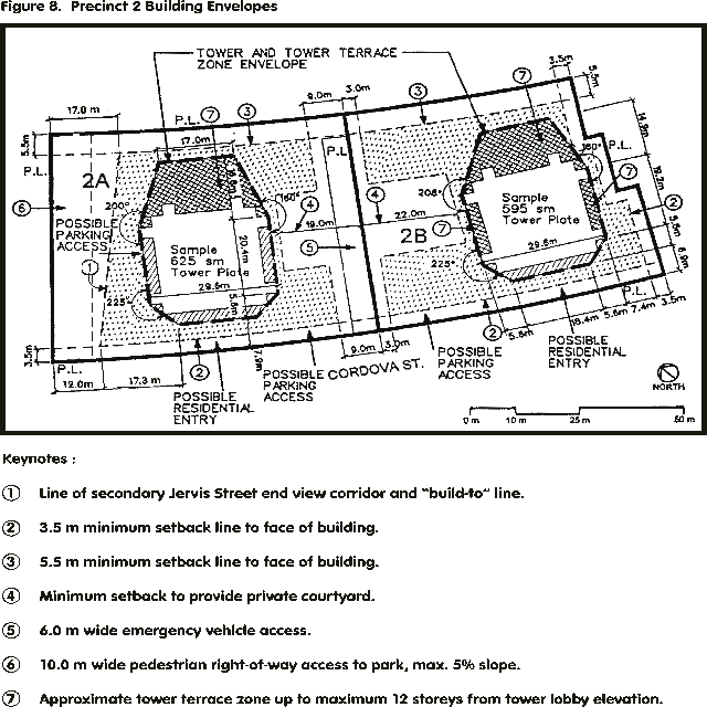
Amend Figure 8. Precinct 2 Building Envelopes on page 14, by amending keynotes #1 and #6, and adjusting the dimensions of the setback line of the Jervis Street end secondary view corridor referred to in Keynote 1 at the bottom of the page, as follows:
- setback at northerly (park edge) build-to line to be 17.0 m; and
- setback at southerly (Cordova Street) build-to line to be 12.0 m.
APPENDIX B
CONDITIONS OF APPROVAL
ALTERNATIVE DRAFT AMENDMENTS TO
COAL HARBOUR OFFICIAL DEVELOPMENT PLAN (CHODP)
(Recommended by Director of Current Planning)Note: All additions are in bold and deletions are shown crossed out (
).(1) Amend Schedule A of By-law No. 6754 by deleting the first word and comma of the second bulleted clause in the fourth paragraph under Section 3.5 Views on page 14, and inserting a new bulleted clause above it as shown below:
3.5 Views
The development of Coal Harbour shall preserve views and maximize potential views of the city’s natural setting and unique features contributing to its special identity, as follows:
Public Street End Views:
All northerly corridor views along existing Downtown north-south streets to the water and mountains shall be maintained. Minor intrusions into the Burrard and Thurlow Street-end view corridors shall be permitted for floating marine vessel berths, and for the lower portions of the Arts Complex building.
A minimum 5 degree view angle from each side of the extension of existing downtown streets shall be taken from the following positions, which vary according to the street location along the waterfront:
· Burrard, Thurlow and Bute Streets; from the south side of the Cordova Street extension;
· Jervis Street; for higher buildings above 10.7 m in height, from the north side of the Hastings Street extension at the corner cut-off junction points; for lower buildings up to 10.7 m in height, from the south side of the Cordova Street extension;
· (
Jervis,) Broughton and Nicola Streets; from the south side of the Hastings Street extension; and· Cardero Street; from a point midway between the north side of Georgia Street and the north side of the waterfront loop road alignment east of Cardero Street.
ALTERNATIVE DRAFT AMENDMENTS TO
COAL HARBOUR OFFICIAL DEVELOPMENT PLAN (CHODP)
(Recommended by Director of Current Planning)(2) Add the following note to Figure 10A Public Street End Views:
“NOTE: Setbacks for lower buildings up to 10.7 m in height on sites adjacent to Jervis Street shall be determined from secondary viewpoints located at the south side of the Cordova Street extension, at each side of Jervis Street.”
NOTE FROM CLERK: APPENDIX D IS NOT AVAILABLE IN ELECTRONIC FORM -ON FILE IN THE OFFICE OF THE CITY CLERK.
APPENDIX E
COAL HARBOUR POLICY STATEMENT
[partial extract of approved policy on public street-end views]POLICY
Ensure that the development preserves most current views and maximizes potential views of the city’s natural setting and unique features contributing to its special identity, in the following categories:
PUBLIC STREET-END VIEWS
Ensure that all northerly corridor views along existing N-S streets to the water and mountains are maintained. Allow only minor relaxations to the minimum 5 degree angle from each side of the extension of existing streets at the CWD zoning boundary or Georgia Street west of Cardero Street within the following guidelines:
· the view reduction is essential to the overall quality of the waterfront development; and/or
· the view reduction is not detrimental to the overall quality of the existing street-end view from the downtown; and/or
· the physical design of the portion of the waterfront development which causes the view reduction is of quality and will enhance the physical character of the immediate surroundings; and/or
· an alternative access to view waterfront activities, Stanley Park, Burrard Inlet and/or the North Shore mountains is provided as a trade-off at a location in the vicinity of a particular street end and is easily accessible to the public from downtown.
NOTE FROM CLERK: APPENDICES F-G ARE NOT AVAILABLE IN ELECTRONIC FORM - ON FILE IN THE OFFICE OF THE CITY CLERK.
APPENDIX H
COMMENTS FROM THE PUBLIC, REVIEWING AGENCIES
AND THE APPLICANTPublic Input: A rezoning sign was erected on the site on November 3, 1999, and a notification letter has been distributed to the surrounding neighbourhood. Staff have received one letter and one phone call concerning the proposed view corridor amendments.
Urban Design Panel: The Panel reviewed the development application for 301 Jervis Street on two occasions; first as a preliminary submission on November 4, 1998 and lastly as a revised complete application on March 24, 1999. The Panel strongly supported the proposed townhouses along the south side of Harbour Green Park and their intrusion into the existing approved street-end view corridor.
Development Permit Board: The Development Permit Board last considered the complete application for 301 Jervis Street (DE403667) on May 5, 1999. Extracts from the minutes of that meeting dealing with the view corridor issue are as follows:
“Development Planner’s Opening Comments: The Development Planner, Mike Kemble, presented this application. . . . The preliminary submission was approved in principle by the Board on December 14, 1998. Three issues remain with respect to the complete submission, relating to public street-end view corridor encroachments, vehicular access arrangements from the Jervis Street right-of-way, and the tower floorplate size. After reviewing view analysis which was not available at the preliminary stage, staff believe the issue of encroachment into the street-end view corridors must be addressed, and condition 1.1 requires adjustment to the massing of the two storey townhouse and amenity pavilion elements to ensure the Jervis Street-end view corridor is preserved. It was noted the Board does not have the authority to relax this ODP requirement. . . .
In the question period that followed, Mr. Beasley noted that, at the rezoning stage, considerable discussion took place with upland owners regarding Coal Harbour tower heights and locations and the zoning and guidelines reflect the understanding that was reached at that time.
Applicant’s Comments: James Cheng, Architect, pointed out that his particular site was not part of the discussions with the upland owners. Those discussions related to the Harbour Green towers which were rezoned almost ten years after this site. The main issue for the upland owners was the width of the towers they would be facing, rather than actual floorplate sizes. It was therefore determined that additional massing would be on the view shadow side to the north rather than to the south or increasing tower width. Referring to an illustration of the public street end view cones, Mr. Cheng explained why he believes this particular site is an exception. He noted as well, that setting back the townhouse component would be contrary to the intent of maintaining continuity with the Harbour Green towers, to define the edge of the park. In summary, he stated they are not asking the Board to relax the view cone but rather to clarify the documentation, noting they believe they are in compliance.
In response to a question from Mr. Beasley, the Development Planner confirmed the view cones are clearly indicated in the Coal Harbour ODP. Mr. Kemble also confirmed that even if the Guidelines are not strictly accurate, the ODP must prevail.
Panel Opinion: Mr. Hruda noted the areas of concern to the Urban Design Panel. . . . With respect to the street-end views, the Panel thought the important principle to be maintained was the definition of Harbour Green. The Panel had no problem that the lower elements extended into the view corridor. . . .
Mr. Kavanagh said he hoped the applicant would seek an amendment to the ODP with respect to the street-end views because it is important that this building connect appropriately with the adjacent buildings.
Mr. Gjernes expressed concern that, if Council does not approve a relaxation of the view corridor, the proposal will differ to the extent that it should come back to the Board. He recommended, however, that the Board might suggest to Council that it is unfortunate that this view corridor prevents the Board from approving what it believes to be most appropriate for this site. . . .
With respect to the issue of street-end views, Mr. Roodenburg said the intent is not clearly defined in the ODP. He recommended there be a clear definition, with examples of other areas where the ODP has been adhered to. . . .
Mr. Chung agreed with the previous speaker regarding conditions 1.1 and 1.3. . . .
Ms. Parton commended the architect on a very attractive building. She agreed with the previous comments about the view corridor and with allowing the townhouses toremain as proposed. She added, it is unfortunate that maturing trees in the city are now obliterating view corridors that were established some years ago. . . .
Concluding Comments from Staff: Mr. Kemble noted that, given a Text Amendment to allow encroachment into the street-end corridor will take approximately 7 to 8 months to conclude, if the application has to come back to the Board for approval it will delay the project considerably. . . .
Board Discussion: Mr. Beasley said he considers this to be an excellent project, and a number of issues have been resolved since the preliminary stage that have resulted in a much better scheme. With respect to condition 1.1, he expressed serious concern about the Board taking a policy decision that should rest with Council. He suggested that, if the applicant is successful in pursuing a Text Amendment, a subsequent revision can be dealt with by the Director of Planning on behalf of the Board. However, for the Board to proceed with this application according to the zoning in place it is important that 1.1 remain. . . .
Ms. Lo agreed this is a good project and supported Mr. Beasley’s motion.
With respect to condition 1.1, Mr. Rudberg suggested that, as a reflection of today’s discussion, the Board offer support for a Text Amendment to allow an intrusion into the view corridor in this case. In discussion, Mr. Scobie agreed it would be appropriate for staff to convey to Council the tenor of the Board and Panel’s deliberations, if and when an application is made, but that it may not be appropriate for the Board to offer advice to Council on a policy matter. A motion from the Board in this respect may also hinder staff’s analysis. Mr. Beasley concurred, noting a key variable for Council will be public commentary on views. While he agreed with some of the discussions about the architecture of this particular proposal, he noted that the established view corridors are in place as a result of public opinion. Mr. Rudberg concurred and withdrew his recommendation.
Motion: It was moved by Mr. Beasley and seconded by Ms. Lo, and was the decision of the Board:
THAT the Board APPROVE Development Application No. DE403667, in accordance with the Development Permit Staff Committee Report dated May 5, 1999, with the following amendments:
Amend 1.1
design development to themassingsetback of the two storey townhouse and amenity pavilion elements along the north and south sides of the site, tocomply withfurther set back these encroachments fromthe ODP and Guideline prescribed 5 degree street-end view corridor on Jervis Street.”(NOTE: other approved prior-to conditions are not included for clarity.)
APPLICANT’S COMMENTS
“The intent of the Public Street-End View Policy was to ensure development preserves most current views and maximizes potential views of the city’s natural setting and unique features. However, under certain guidelines, minor relaxation to the minimum 5 degree angle could be allowed. We concur with Staff’s analysis and conclusion that the proposed relaxation would not have a significant impact on the Jervis street-end view. We only differ in the extent of the relaxation.
We would like to point out that the Urban Design Panel strongly supported the proposed townhouses (Appendix A) along the south side of Harbour Green Park and their intrusion into the existing approved street-end view corridor. In addition, the advisory panel to the Development Permit Board also supported the same townhouse intrusion. There were discussions from several members of the Development Permit Board to “convey to Council the tenor of the Board and Panel’s deliberations”. The full transcript is contained in Appendix H.
We urge Council to consider Appendix A for the following reasons:
· The low-rise buildings have minimum impact on the street-end views of mountain and sky from the downtown as the topography rises sharply towards downtown.
· The public has full access to the waterfront via Harbour Green Park, which is not the case with most other street-end views.
· The fuller extent of townhouses fronting on Harbour Green Park will provide a safer public environment by increasing the amount of “eyes of the street”.
· The fuller extent of townhouse further reinforces the edge definition of Harbour Green Park, thus giving a clearer sense of the public domain, enhancing the quality of the waterfront development in keeping with the Harbour Green area design guidelines.
· The physical design of the portion of the waterfront development that causes the view reduction is of extremely high quality and will enhance the physical character of the immediate surrounding. Extensive soft and hard landscaping as well as building materials and detailing are provided.
· The park and underground community centre immediately adjacent to the southwest provides an alternative access to view waterfront activities, Stanley Park, Burrard Inlet and the North Shore mountains as a trade-off and is completely accessible to the public from downtown.In short, the proposed relaxation (Appendix A) is in complete compliance with the relaxation guidelines set out under the Public Street-End Views section of the Coal Harbour Policy Statement (reproduced in full in Appendix E).”
![[City Homepage]](/graphics/footnava.gif)
|
![[Get In Touch]](/graphics/footnavb.gif)
|

|

|

|
(c) 1998 City of Vancouver