ADMINISTRATIVE REPORT
Date: October 25, 1999
Author/Local: R.Louie/7156RTS No.00917
CC File No. 8205Council: November 30, 1999
TO: Vancouver City Council FROM: General Manager of Engineering Services, in consultation with the Director of Current Planning and the Manager of Parks and Recreation SUBJECT: Shoreline Protection Works / Handrail Design for the Beach Neighbourhood - Area 1 RECOMMENDATION
A. THAT Council approve the design and location of handrails along Segments 1, 2, 4, 5 and 6 of the pedestrian and bicycle pathway as shown in Appendix A.
CONSIDERATION
B. THAT Council approve the design of the seawall walkway to exclude handrails from the locations shown in Appendix A as Segment 3.
- OR -
THAT Council approve the design of the seawall walkway to include handrails in the locations shown in Appendix A as Segment 3.
COUNCIL POLICY
On July 27, 1999, Council approved the design of the shoreline protection works and the pedestrian/bicycle pathway for Area 1 Beach Neighbourhood, but deferred the approval of the handrail design pending a report back from staff.
On April 2, 1996, Council approved the rezoning of Beach Neighbourhood East - Area 1B. As a condition of rezoning, the developer is required to design and construct shoreline protection works and a waterfront pedestrian/bicycle pathway.
PURPOSE
This report seeks Council approval and direction on the design and location of the handrails along the shoreline pathway in the Area 1 Beach Neighbourhood. This report also provides further information on the appropriateness of right angle turns along the bicycle path as requested by Council.
SUMMARY
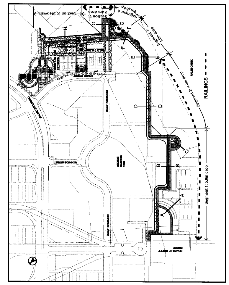
The existing conditions of the Area 1 shoreline and the proposed design are summarized in the table below. For discussion purposes, the seawall has been divided into 6 segments based on the height of the vertical drop.
Existing Condition Existing Railings Proposed Design Vertical Drop Proposed Railings Segment 1 Decking on Piles Yes Retaining wall 5.0 metres (16.4 feet) Yes Segment 1
Stepwall3 Existing Stepwalls No Retain Stepwalls 2.0 metres steps (6.6') Yes Segment 2 Decking on Piles Yes Retaining wall 4.0 metres (13.1 feet) Yes Segment 3 Rough Slope No Retaining wall 1.0 metres (3.28 feet) For Consideration Segment 4 Rough Slope No Landscaped slope 0 metres No Segment 5 Rough Slope No Retaining wall 2.4 metres (7.9 feet) Yes Segment 6 Rough Slope Yes Stepwall 300 mm steps No Staff recommend the installation of railings along Segments 1, 2, 4 and 5 of the Area 1 Beach Neighbourhood shoreline, recommend no railings along Segment 6, and seek Council direction on the extent of railings along Segment 3.
DISCUSSION
On July 27, 1999, Council approved the design of the shoreline protection works, seawall treatment, and the pedestrian / bicycle pathway design for the Area 1 Beach Neighbourhood. At that time, Council requested further information regarding the location of the proposed handrails, existing conditions, and the vertical drops at various seawall locations, prior to approving the design of the handrails along the Area 1 shoreline.
The design of the handrails along the walkway, as shown in Figure 1 below, is similar to that used in the Roundhouse and Quayside Neighbourhoods. The handrail is designed to be difficult to climb over or through and minimizes view blockage.
Figure 1 - Typical Handrail
Staff are seeking Council's approval and direction on the locations where handrails are to be used along the walkway. This issue involves the need to balance aesthetic objectives against safety concerns and potential liability for the City. In October 1991, Council approved, as part of the conceptual shoreline design report, that "shoreline handrails be kept to a minimum" to limit view obstruction. The process endorsed by Council for reviewing handrail requirements involved the assessment of each area based on its particular circumstances, while addressing the following factors:� Building By-law requirements;
� precedents for handrails in the City;
� height of vertical drop;
� use of area (assembly, view lookout, offshore activity);
� proximity to schools, playgrounds, shopping areas;
� capital, maintenance, and potential legal cost implications.The Building By-law requires all drops over 600mm (2 feet) to have guards. While the Building By-law does not apply to City streets, which include the shoreline, it is often used as a guideline.
Council dealt with this issue previously when considering the shoreline design for the Roundhouse Neighbourhood and for the Quayside Neighbourhood. After considering a number of criteria, Council approved a shoreline walkway design for the Roundhouse Neighbourhood without handrails in locations where the vertical drop is 2.35m (almost 8 feet). In the Quayside Neighbourhood, segments of the shoreline walkway with 5.0 m, 3.0 m, and 2.0 m vertical drops, were approved by Council with the installation of railings. In the Segment of the shoreline walkway in Quayside with a 1.0 m vertical drop, Council approved a design without handrails.
The proposed Area 1 shoreline design can be divided into 6 segments of differing vertical drops as shown in Appendix A and in Figure 2 below. Specifically, the vertical drops for each segment are as follows:
Segment 1: 5.0 metres (16.4 feet)
Segment 2: 4.0 metres (13.1 feet)
Segment 3: 1.0 metres (3.28 feet)
Segment 4: 0 metres (Landscaped Slope)
Segment 5: 2.4 metres (7.9 feet)
Figure 2 - Area 1 ShorelineSegment 6: Stepwall
Segment 1 (A-A) - Railings Proposed - 2.0 m Stepwalls: At the western end of the shoreline, there are 3 existing stepwalls, each with a 2.0 metre drop. Although there are currently no railings along these stepwalls, this area is fenced off from public access. Figure 3 below shows a cross-section of the proposed design which retains the stepwalls, but retrofits the edge with railings.
Staff recommend approval of railings along this stepwall, which fronts onto the secondary pedes trian walk way 3.6 metres (12 feet) wide.
Existing Condition A-A
Figure 3 - Proposed Design A-A
Segment 1 (B-B) - Railings Proposed - 5.0 m drop: The existing condition at cross-section B-B consists of decking on piles with existing railings. Figure 4 below shows a cross-section of the proposed design indicating the installation of stresswalls and railings.
Staff recommend the approval of railings to replace those currently in place, as the 5.0 metre (16.4 feet) drop represents a hazard. Although this section fronts onto George Wainborn Park, view blockage is minimal due to the rising grade of the park.
Existing Condition B-B
Figure 4 - Proposed Design B-B
Segment 1 (C-C Bullnose Promontory) - Railings Proposed - 5.0 m drop: The existing condition of cross-section C-C consists of a concrete retaining wall with existing railings. Figure 5 below shows a cross-section of the proposed design, which retains the existing concrete wall around the Bullnose Promontory, and retrofits the railings.
Staff recommend approval of railings to replace those currently in place, as the 5.0 metre (16.4 feet) drop represents a hazard.
Existing Condition C-C
Figure 5 - Proposed Design C-C
Segment 2 (D-D) - Railings Proposed - 4.0 m drop: The existing condition for this segment consists of decking on piles with existing railings. Figure 6 below shows the proposed design for this segment, which provides for a new stresswall and the inclusion of handrails.
Staff recommend the approval of handrails along this segment to replace those currently in place, as the 4.0 m drop represents a safety hazard.
Existing Condition D-D
Figure 6 - Proposed Design D-D
Segment 3 (E-E) - 1.0 m drop: This segment currently does not have any railings, and consists of a rough slope. The design proposed by the developer, as shown in Figure 7 below, consists of a concrete retaining wall with a vertical drop of 1.0 m (3.28 feet), with planter areas and potential fish habitat adjacent the seawall. This segment of the seawall is proposed with stone caps only, without handrails, and would be very similar to the situation found in the Quayside segment of seawall with no handrails.
Existing Condition E-EAlthough Engineering, from a professional perspective, must recommend handrails at all locations where the vertical drop is greater than 600 mm as specified for private property in the Building By-law, Council may wish to consider other factors listed in the process endorsed in 1991, which support the exclusion of handrails. In the Quayside Neighbourhood, there is a similar situation with a 1.0 metre vertical drop with adjacent planter areas where Council excluded handrails. In the Roundhouse Neighbourhood, there is a segment of the seawall with a vertical drop of 2.35 metres, where Council approved a design without handrails. Therefore, factors such as previous shoreline precedents, the aesthetic benefits to the walkway, and mitigative effect of the adjacent planter areas, may warrant Council consideration of a design without guardrails.
Figure 7 - Proposed Design E-E
Segment 4 (F-F) No Railings Proposed - 0 m drop: This segment currently does not have any railings, and consists of a rough slope. Along this segment, the shoreline pathway leads inland in the proposed design with a landscaped park feature leading to a cobble beach, as shown in Figure 8 below. As there are no vertical drops, only stone caps are proposed with no railings.
Existing Condition F-F
Figure 8 - Proposed Design F-F
Segment 5 (G-G) - Railings Proposed - 2.4 m drop: This segment currently has no railings and consists of a rough slope. This segment of the shoreline will encompass the Beach Avenue pedestrian extension through the park which leads to the future ferry dock. The proposed design consists of a concrete retaining wall with a vertical drop of 2.4 m (almost 8 feet) with railings proposed. The existing slope is cut down to achieve sufficient water depth for the ferry dock. Staff recommend the installation of railings along this segment which would function as a viewing promontory and a gathering location for the ferry dock.
Existing Condition G-G
Figure 9 - Proposed Design G-G
Segment 6 (H-H) - No Railings Proposed - Stepwall: The existing condition along this segment consists of a rough slope with railings. This segment of the seawall at the eastern end of Area 1 in front of David Lam Park Extension, is designed as a step wall to provide access to the water. Between the shoreline pathway and the water is a landscaped strip 3.0 m wide, followed by 2 seat wall steps dropping down 600 mm (2 feet) to a secondary walkway 3.0 m wide, and finally leading to the step wall to the water. No railings are proposed in the stepwall segment of the seawall. Staff recommend the stepwalls be approved without railings, as the stepwalls are designed to provide access to the water.
Existing Condition H-H
Figure 10 - Proposed Design H-H
Pedestrian/Bicycle Pathway
At its meeting of July 27, 1999, Council requested further information on the appropriateness of right angle turns on the bicycle pathway. The pedestrian and bicycle pathways in Area 1 are designed to be separated paths with asphalt treatment on the bicycle path, concrete paver treatment on the pedestrian path, and a landscaped median. There are a number of right angle turns along this pathway to accommodate the shoreline edge around George Wainborn Park. Staff will ensure that the appropriate radius of curvature to allow for bicycle movements at the design speeds for shoreline walkways be applied at the detailed design stage of the shoreline pathways.
Figure 11 - Shoreline Pathways
CONCLUSION
The shoreline treatment and the pedestrian/bicycle route design has been approved by Council on July 27, 1999. Staff recommend the approval of the preliminary design and location of the handrails along Segments 1, 2, 4 and 5, which in most cases, are to replace existing railings in the current shoreline, and seek Council direction on the requirement of handrails along Segment 3 with a 1.0 metre drop.
- - - - -
APPENDIX A
Comments or questions? You can send us email.
(c) 1998 City of Vancouver