|
|
POLICY REPORT
URBAN STRUCTURE
Date: July 16, 1999
Author/Local: Ian Smith/7846 &Michael Naylor/7237
RTS No. 00173
CC File No. 5304-1Council: July 27, 1999
TO:
Vancouver City Council
FROM:
Director of Current Planning, in consultation with the General Manager of Engineering Services, the General Manager of Parks & Recreation, the Director of Social Planning, and the Director of Legal Services
SUBJECT:
555 Great Northern Way - Rezoning of Finning Lands
RECOMMENDATION
A. THAT the application by Finning International Inc., to rezone 555 Great Northern Way from I-3 to CD-1, to permit industrial, office, commercial and residential live-work uses, consistent with the Concept Plan for Great Northern Technology Park submitted in March 1999, be referred to Public Hearing, together with:
i) plans received July 15, 1999;
ii) draft CD-1 By-law provisions generally as contained in Appendix A;
iii) the recommendation of the Director of Current Planning to approve the application, subject to conditions of approval contained in Appendix B;
iv) draft design guidelines generally as contained in Appendix C.
FURTHER THAT the Director of Legal Services be instructed to prepare the necessary by-laws for consideration at Public Hearing generally as presented in Appendix A and including amendments to the Sign By-law to establish regulations for the CD-1 in accordance with Schedule B (I-3).
B. THAT the public benefit package, outlined in this report to be secured prior to enactment of this rezoning by-law, be accepted as an in-kind Community Amenity Contribution (CAC) in lieu of a cash CAC payment.
C. THAT, because of substantial contributions to facilities that would qualify for Development Cost Levy (DCL) funding being proposed in this application, the Finning site not be included in the area covered by any area-specific DCL which may be adopted for the False Creek Flats.
D. THAT Recommendation A be adopted on the following conditions:
i) THAT the passage of the above resolution creates no legal rights for the applicant or any other person, or obligation on the part of the City; any expenditure of funds or incurring of costs is at the risk of the person making the expenditure or incurring the cost;
ii) THAT any approval that may be granted following the Public Hearing shall not obligate the City to enact a by-law rezoning the property, and any costs incurred in fulfilling requirements imposed as a condition of rezoning are at the risk of the property owner; and
iii) THAT the City and all its officials, including the Approving Officer, shall not in any way be limited or directed in the exercise of their authority or discretion, regardless of when they are called upon to exercise such authority or discretion.
GENERAL MANAGER'S COMMENTS
The General Manager of Community Services RECOMMENDS the approval of the foregoing.
CITY MANAGER'S COMMENTS
The City Manager RECOMMENDS approval of A, B, C and D. In addition, the City Manager notes that some of the issues raised by the developer need further discussion and clarification. Therefore, should Council approve the report, staff will meet with the developer to try to resolve issues of concern, and report in detail at the Public Hearing.
COUNCIL POLICY
Relevant Council policy includes:
·Industrial Lands Policy, approved in 1995
·False Creek Flats Preliminary Concept Plan, approved in 1996
·I-3 Zoning for High-Technology Industries, approved July 6, 1999
·Vancouver Greenways Plan, adopted July 1995
·Public Art Policies and Guidelines, adopted 1994
·Civic Childcare Strategy, adopted 1990
·Interim City-wide Community Amenity Contribution (CAC) Policy, approved in January 1999PURPOSE AND SUMMARY
This report evaluates an application by Finning International Inc. to rezone 555 Great Northern Way (the Finning Lands) from I-3 Industrial to CD-1 Comprehensive Development to permit development of a high technology industrial park (see Site Location, Figure 1). CD-1 zoning is a major step in the implementation of a vision for this site that will see many new jobs added by a rapidly growing industrial sector.
Figure 1 - Site Location (and I-3 District)The intent of the zoning is that most of the floor space permitted on the 10.7-ha (26.5-ac.) site will be devoted to high technology industrial uses, including the following:
·information technology (IT)
·software development
·telecommunications
·medical, pharmaceutical and biotechnologies
·energy and environmental technologies
·multimedia and film post-productionThe gross floor area proposed in the by-law is 321 282 m2 (3,458,364 sq. ft.) based on the existing density of 3.0 FSR, however under the concept plan, after providing roads and open space, only about 204 380 m2 (2,200,000 sq. ft.) is expected to be achievable. This will provide space for around 6,000 workers in a range of jobs. About a third of the space can be for office uses including the accessory administrative and marketing functions of high-tech companies and other offices of support services.
The Finning CD-1 will also include additional land use options which are not available in I-3. About 15% of the floor space may contain other non-industrial uses which are integral to the high-tech park concept, as they will serve the worker population and businesses and help to create a successful campus environment. These uses include:
·retail, service and restaurant uses - up to 15 793 m2 (170,000 sq. ft.)
·hotel use - up to 9 290 m2 (100,000 sq. ft.)
·commercial live-work use - up to 16 722 m2 (180,000 sq. ft.)The benefit the applicant derives from rezoning to CD-1 is the flexibility in the land uses which will enable the creation of a successful high-tech industrial park. There are also numerous public and local neighbourhood benefits which will be secured on this site. These include:
· About 1.5 ha (4.0 ac.) of open space, landscaped easements and setbacks, including a City-owned open space of 0.5 ha (1.3 ac.);
· New streets which will open up the False Creek Flats to greater public access, and the upgrading of Great Northern Way to a landscaped boulevard;
· On- and off-site infrastructure requirements;
· Greenway and bicycle routes;
· Landscaped easements for Brewery and China creeks allowing the opportunity for their future daylighting;
· Childcare and public art;
· The additional commercial uses which will serve the local community, as well as the high-tech workers;
· A height strategy which will reduce view impacts on neighbouring residential areas and protects public street-end views.Staff support this rezoning with conditions and the Director of Current Planning recommends that the application be referred to Public Hearing.
BACKGROUND
The Industrial Lands Policy, adopted by Council in 1995, retained the False Creek Flats for industrial uses. Then the False Creek Flats Preliminary Concept Plan of 1996 identified the Finning Lands as a suitable location for a "high-amenity, urban, high-tech industrial park." In 1999, a new high-tech industrial district, I-3, was introduced in the western and southern portions of the Flats, including the Finning site.
Finning International Inc. has operated a heavy equipment dealership on the Great Northern Way site since the 1960s. After many successful years and numerous expansions at this site, the company has begun to relocate outside of Vancouver. The current planning initiative would see Finning gradually phased out, with all of their land redeveloped for high-tech industrial use. One lot of 0.9 ha (2.3 ac.), at 887 Great Northern Way, has already been sold by Finning and a building is currently being constructed for QLT Phototherapeutics Inc. (this site is not part of the rezoning).
Finning International has actively participated in False Creek Flats planning initiatives. In July 1998, Council approved a planning process which was funded by Finning to develop a concept plan and recommend zoning for a high-amenity, urban, high-tech industrial park on their site. The first stage was to understand the needs of high-tech industries, particularly those in urban locations. Several joint research visits were undertaken by City staff, Finning and a high-tech development consultant to locations in the Greater Vancouver area and in the United States. The findings were published by the City in September 1998 in a discussion paper entitled "High-Tech Industry in the Urban Context."
In British Columbia, the high-tech sector has grown significantly and has now outpaced that of the province's traditional resource-based industries. While Vancouver has had a share of this growth, the lack of appropriately zoned land has forced a number of high-tech firms to relocate to suburban areas.
DISCUSSION
The 10.7-ha (26.5-ac.) site area proposed in this rezoning only includes property owned by Finning. It does not include the 3.4-ha (8.4-ac.) Burlington Northern Santa Fe (BNSF) rail yard to the north of Finning nor several smaller properties along Industrial Avenue, although these lands were included in the planning process. These properties cannot be in the CD-1 rezoning at this time due to unresolved soils issues. However, they will still likely participate in the high-tech park as they are within the new I-3 District.
Proposed Land Uses
The CD-1 for Finning takes the I-3 District Schedule as the basis for its land use regulation and adds several non-industrial uses which have been identified as important in the success of high-tech industrial parks.
Consistent with the I-3 Schedule, high-tech and other light industrial uses will occupy the majority of the floor space. In fact, all of the permitted floor area may be devoted to these uses and to "Information technology" which, as in I-3, is the only office use permitted to full density. In I-3, other office uses are conditional, limited to 33_% of the total floor area and must accompany the two-thirds industrial. Under the Finning CD-1, these office uses will be by outright approval, but they will be limited to 55 740 m2 (600,000 sq. ft.) or 17.3% of the total floor area.
Unique to the Finning CD-1 will be additional non-industrial uses which are identified, by user groups in the discussion paper "High-Tech Industry in the Urban Context," as needed to create a desired level of amenity for high-tech workers. Included will be additional general office space which may be occupied by accountants, lawyers, insurance and travel agencies, etc. These types of office uses are not permitted under the I-3 Schedule, but which may have a need to locate in close proximity to high-tech industry clients. For example, accountants who administer venture capital funds may need offices in the high-tech park, as may lawyers who handle software copyright agreements. These non-I-3 office uses will be limited to 5 574 m2 (60,000 sq. ft.) or 1.7% of the total floor area.
The Finning CD-1 will also expand retail, service and restaurant uses which are quite restricted in the I-3 Schedule, yet are important in a high-tech park. Up to 15 793 m2 (170,000 sq. ft.) or 4.9% of the total floor area may be occupied by retail, service and restaurant uses which will line the streetfront edges of a new central avenue and focus around a triangular open space. The anticipated businesses include coffee shops, convenience stores, various types of restaurants, dry-cleaners, computer supply stores, print and copy centres, etc. While primarily intended to serve the workers of the high-tech park, these businesses will also serve the surrounding residential and live-work neighbourhoods, which are currently under served with commercial uses.
A moderately sized hotel is also proposed for the Finning site. Many high-tech companies operate on a global scale. They frequently have employees and visitors coming in from other cities for short-term contracts or training sessions. User groups have clearly identified a desire for a hotel nearby that can meet their short-term accommodation needs. Therefore, up to 9 290 m2 (100,000 sq. ft.) or 2.9% of the high-tech park's floor space is allocated for hotel use.
For commercial live-work use a maximum of 16 722 m2 (180,000 sq. ft.) or 5.2% of the total floor space may be used. This would be located at the western end of the site adjacent to the Brewery Creek Artist Live-Work Neighbourhood. Rather than artists, it would be geared more toward high-tech workers, and could function as "incubator" space for small start-up companies. Both the hotel and live-work uses will help to create a 24-hour presence in the high-tech park, heightening security and providing business for the shops and restaurants outside of office hours. For these reasons, these uses have been supported by the adjacent community, the Urban Design Panel and the City Planning Commission.
The following table summarizes the proposed land uses and their floor area maximums. Note that the maximum floor area for all uses combined is 321 282 m2 (3,458,364 sq. ft.). The 100% of floor space initially available for industrial and information technology uses will be reduced by whatever other uses are provided. This maximum reflects the 3.0 FSR currently permitted under the I-3 zoning. Constraints imposed by new roads, open space and height limits will reduce this total, as evidenced in the current design which would accommodate about 204 380 m2 (2,200,000 sq. ft.) of floor area.
Table 1 - Proposed Floor Area Maximums
USE
MAXIMUM
TOTAL FLOOR AREA% OF TOTAL FLOOR AREA
I-3
USESHigh-tech Industrial and Information Technology (and Accessory Uses)
321 282 m2 (3,458,364 sq. ft.)
100.0%
Office Uses (like the I-3 office component, but with outright approval)
55 740 m2 (600,000 sq. ft.)
17.3%
NEW
USESOffice Uses (including those not permitted in I-3, i.e. lawyers, accountants, insurance, travel agents)
5 574 m2 (60,000 sq. ft.)
1.7%
Retail, Service and Restaurant Uses
15 793 m2 (170,000 sq. ft.)
4.9%
Commercial Live-work
16 722 m2 (180,000 sq. ft.)
5.2%
Hotel
9 290 m2 (100,000 sq. ft.)
2.9%
ALL USES COMBINED
321 282 m2 (3,458,364 sq. ft.)
100.0%
Street Pattern and Traffic
The proposed street system is articulated around an east-west "central avenue" and a series of north-south streets which, in the short term, will form the basic circulation system to serve the site and provide access from Great Northern Way. In the long term, the street grid is an important part of a new urban structure for the False Creek Flats, linking Great Northern Way to Industrial Avenue, and eventually north to Terminal Avenue.
The main features of the proposed street system are as follows:
· It will set up a new grid which will fit into the existing street system, opening up the False Creek Flats to greater public access.
· The "central avenue" will be part of a greenway route, and will function as the main street for the high-tech park in terms of street activity. It will encompass the 0.5-ha (1.3-ac.) open space and be the focus of the retail and service activity.
· Three north-south streets will provide access from Great Northern Way by signalized intersections. One of these streets will eventually become an extension of Industrial Avenue, establishing an important arterial connection between Great Northern Way and Main Street. Three, or perhaps two, additional north-south streets will complete the internal street system to service the future development. The location and number of these narrower rights-of-way are subject to the final subdivision pattern.
· The intersection of Great Northern Way and Brunswick will be reconfigured to normalize access to the site while deflecting additional traffic from existing residential neighbourhoods.
Figure 2 - Proposed Street PatternA traffic study is being completed by the applicant to further examine the impacts of the proposed development on the existing transportation infrastructure and the neighbourhood to the south. Designs will be pursued that minimize the intrusion into the residential area by directing traffic onto Great Northern Way, and in the future, onto Industrial Avenue. There has been little concern expressed on this issue at the public meetings held, likely due to the lack of direct connections and proposed traffic controls on the existing connections. Additional information will be available for Council, prior to the Public Hearing, dealing with traffic impacts and design options.
Pedestrian and Bicycle Movements
The pedestrian and bicycle linkages proposed are represented in the following Figure 3. The primary bicycle route connecting the False Creek waterfront system with the B.C. Parkway route is proposed as a dedicated lane along Industrial Avenue. Pedestrian linkages utilize the greenway proposed for Central Avenue as well as the China Creek and Brewery Creek rights-of-way. The configuration and geometrics will be finalized with the applicant and reported back to Council, with particular regard to achieving safe and comfortable connections for pedestrians and cyclists between existing neighbourhoods and the proposed development. In addition to pedestrians and bicycles, opportunities for in-line skating will be explored in the design of the proposed system.
Figure 3 - Pedestrian and Bicycle Movements
Building Form and HeightThe net density of the proposed high-tech park, at a maximum 3.0 FSR, is far greater than suburban business parks. The built form is therefore to take on a more urban character. Buildings are to provide a generally continuous edge definition for the streets, particularly for the central avenue. To avoid flat, unrelenting facades, the design guidelines encourage individual building identification, facade articulation, the use of different materials and breaks to provide entrances to courtyards and pedestrian amenities. Parking is to be generally underground or concealed within the structures.
For many years industrial buildings have been built with heights far below what the zoning allows. This is clearly demonstrated in the existing buildings on the Finning site which are less than 8 m (25 ft.) in height. The future high-tech buildings are expected to be taller, taking full advantage of the maximum heights permitted in the I-3 Schedule of 18.2 m (60 ft.) outright and discretionary approval up to 30.5 m (100 ft.).
Under the proposed CD-1 by-law, the maximum height will generally be set at 18.2 m (60 ft.). Variations which would restrict height in some areas and permit higher buildings in others have been included mainly in response to views from residential developments on the hillside south of Great Northern Way. To reduce the view impacts, the height of buildings along the 500, 600 and 700 blocks of Great Northern Way will be limited to 13.7 m (45 ft.) in the front half of the blocks. While there will still be some view blockage from lower units near Great Northern Way, this will preserve views from the upper floors of most of the buildings on the north side of 5th Avenue and nearly all views from buildings further to the south. (See Diagram 2 - Maximum Building Heights, Appendix A, page 7 of 8)
Street-end view corridors are also included in the guidelines, which will preserve public views from Mount Pleasant streets at 5th Avenue and southward. Heights within the corridors will be restricted to 13.7 m (45 ft.), permitting views over the new development. (See Figure 2 - Street-end View Corridors, Appendix C, page 6 of 13)
In exchange for lowering heights below the outright permitted in these locations, higher buildings, up to 36.6 m (120 ft.), will be allowed in other locations on the site where the view impact is not as great. The taller buildings are proposed primarily in the western end of the site, where soil conditions are more favourable to greater building mass and underground parking, and in the eastern end adjacent to the new QLT building. In the remaining areas of the site the height limit will be 18.2 m (60 ft.).
Community Amenity Contribution (CAC) and Development Cost Levy (DCL)
After January 28, 2000, any development on the Finning site will be subject to the City-wide DCL of $10.76/m2 ($1.00/sq. ft.) for non-residential use and $26.91/m2 ($2.50/sq. ft.) for residential use, including live-work. As the current proposal requires a rezoning, the site is also subject to the Interim City-wide CAC Policy for those land uses not permitted under the existing I-3 zone. On about 47 379 m2 (510,000 sq. ft) this would be $1,530,000. As the site is over 4.0 ha. (10 ac.), an amenity package, in this amount or greater, can be negotiated as in-kind amenities rather than a cash payment. With this in mind, a full range of public benefits and infrastructure requirements have been negotiated, as set out below.
With a total value of amenities and off-site infrastructure over $8,000,000, plus another $8,000,000 for on-site infrastructure, this far exceeds the Interim CAC and includes many capital projects which would be eligible as DCL fundable items. It is recommended that this package be accepted as a CAC in kind and in lieu of any area-specific DCL which Council may impose for the balance of the False Creek Flats area.
Public Amenities
Infrastructure - All on-site works for servicing the development, including dedications and rights-of-way, will be secured through agreements as a condition of the rezoning enactment. These works, services, dedications and rights-of-way will be provided at no cost to the City. Additional contributions to off-site works will also be secured through the servicing agreement. The final contribution amounts will be determined generally based on the off-site impacts of the proposed development on the existing infrastructure.
Usable Open Spaces - In total, about 1.6 ha (4.1 ac.) of open space will be provided in the form of green spaces and landscaped easements and setbacks. This represents about 15% of the total site area. The main element is a triangular-shaped open space, to be City owned, at the western end of the site. It will be in the middle of the central avenue, providing a common green on which the buildings will front and a focus for the pedestrian activity along the street. While it will primarily serve the break-time needs of the high-tech workers with both passive and active functions, it will also serve needs of the surrounding residential population. It may, for example, be used on the occasional weekend by the Brewery Creek residents for special events and have a stage to facilitate this use.
Two landscaped green spaces will also be provided along the China Creek and Brewery Creek stream easements. While these easements are reserved for potential stream daylighting, they will be landscaped in the interim to provide additional green space as well as pedestrian paths.
Greenways - The central avenue will form part of a greenway route linking the False Creek Flats to the BC Parkway route, as per the approved City-wide Greenways plan. It is envisioned as a pedestrian and bicycle friendly street which will be the focus of the retail and service activity. (See Figure 3 - Pedestrian/Bicycle System, page 9.)
Stream Easements and Future Opportunities for Daylighting - The historic mouth of Brewery Creek is located south of 1st Avenue, near the western end of the Finning site. Under an initiative independent of this rezoning, an arrangement is being made to commemorate Brewery Creek at this location. This will continue into the Finning site within a 15-m (50-ft.) wide setback along the western edge of the property, which will be landscaped to provide additional green space and pedestrian paths (see Brewery Creek/Finning Plan, Appendix D, page 2 of 9). China Creek currently flows in an undergroundculvert in a 15-m (50-ft.) wide easement at the eastern end of the site. This easement is to be landscaped and have a pedestrian path along its length. Both easements will allow for possible future daylighting of the creeks.
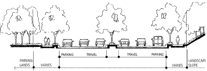
Great Northern Way Landscape Setback - Another feature includes retention of a landscape setback along Great Northern Way, where the existing mature vegetation currently serves as a buffer to the adjacent residential community.
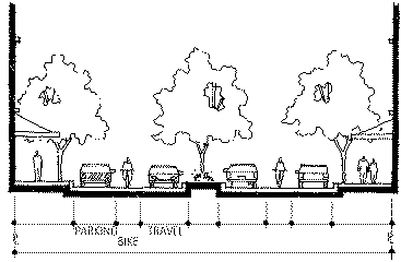
Streetscaping and Boulevard Treatments - The central avenue will be designed and built to reinforce the character of the high-tech park using special paving, lighting, and furnishing treatments and generous tree plantings. Great Northern Way will be reconstructed with a treed centre median.
Childcare Facility - Since approval of the Civic Childcare Strategy by Council in 1990, all industrial rezonings in the city have been assessed as to their childcare demand according to 1 space per 100 workers. This industrial childcare calculation takes into account that only 25% of employees with preschool-aged children would use on-site childcare facilities. To date, none of the projects reviewed have been large enough to generate the minimum-sized 24-space facility.
Finning is the first industrial project to come forward with enough workers to require the provision of a childcare facility. Using the low end of the high-tech industry standard of 3 workers per 1,000 square feet of built-out space, the development planned for the Finning site creates a childcare demand of 60 spaces. This translates into a functional facility of 56 spaces. The requirement would have the applicant make arrangements to cover all costs for construction of the facility.
The applicant believes that the provision of childcare is important for the high-tech park, but feels that it will be provided by the businesses who locate there as a necessary benefit to attract and retain employees and that it need not be a rezoning requirement. In support, examples of high-tech parks in the United States are noted, where childcare and even schools are provided on site. Staff note, however, that there are no known Canadian examples where high-tech firms have voluntarily provided childcare.
To respond to both concerns, staff believe that the delivery of the required childcare facility can be delayed until 50% of the anticipated development floor area is occupied. Staff also propose that the City childcare requirement be secured in such a way as to allow a reduction in the overall size of the childcare facility by the number of childcare spaces already provided on-site by the high-tech industries. While the applicant would prefer that childcare not be a City requirement and that it be left up to the marketplace, they are prepared to accept the staff recommendations if required by Council.
Public Art - The unique scale and use proposed for the Finning site poses challenges to existing City policy. The Public Art Program applies to all floor areas contributing to the FSR calculations in rezonings over 1 500 m2 and in those which result in a change from industrial to commercial or residential use. In the downtown mega-projects, where all industrial use is converted to more urban uses, the calculation for public art would apply to all floor area.
In light of the continuing industrial nature of the Finning site, staff recommend that the public art requirement apply to only the commercial and residential floor area which is being added by the rezoning. This comprises about 15% of the total floor area, with the other 85% remaining the same as I-3. Up to 47 379 m2 (510,000 sq. ft.) of these new commercial and residential uses would generate up to $484,500 for public art. The applicant does not agree with public art being a City requirement and would prefer that its provision be left up to the marketplace.
Rapid Transit
The Finning site is presently not served by public transit, although transit service is recognized by both staff and the applicant as an ingredient essential to the success of the development. For this reason, both Finning and staff have been working with the Rapid Transit Office to explore a routing option for the SkyTrain that would bring a line through or near the Finning site as part of the first phase of construction. From staff's perspective this is now the preferred alignment. Discussion on routing options for the SkyTrain is the subject of a separate report to Council to be considered together with this rezoning referral.
A SkyTrain route through the Finning site does have implications on the urban design proposed in the CD-1, however the extent of those implications depends on whether an underground or elevated alignment is contemplated. Finning's architectural consultants have shown that an underground alignment can be achieved within the current concept plan, but the full cost considerations of this have yet to be explored. An elevated or at-grade treatment in the current alignment would pose serious urban design concerns and would require reconsideration of the plan. Some flexibility has been built into the rezoning conditions to allow for such reconsideration without amending the CD-1 By-law.
A final agreement has yet to be done between Finning and the Rapid Transit Office. The understanding to date is that Finning will provide the right-of-way, and the Province will pay for construction costs, including the undergrounding of the line and the proposed station. In any event, whatever arrangements are made, there will be no costs to the City.
Parking & Loading
Parking for the high-tech park will generally be located underground, although some interim surface lots may be allowed during the early phases of development subject to design, access, and landscaping conditions as determined by the Director of Planning. Staff recommend that the parking and loading requirements for the Finning site be the same as the existing I-3 requirements for the False Creek Flats, which set a maximum parking ratio for high-tech industrial and general office uses at one space for each 42 m2 of gross floor area (2.21 spaces per 1,000 sq. ft.). Parking requirements for the other uses proposed for the site are recommended to be in accordance with the Parking By-Law, including the commercial live-work use which will follow the requirements for artist studios. Loading requirements for commercial live-work use are to be determined on a case-by-case basis at development. Generally for the entire site, off-street loading facilities will be particularly important, and should be accessed through the main north-south streets.
To make this site competitive in attracting high-tech industries, the applicant wants a higher parking ratio than staff are recommending, noting that the site is less accessible by transit than the rest of the False Creek Flats I-3 District, which is closer to the Main Street bus routes and SkyTrain station. The applicant also cites the Bentall I-3 site in Grandview-Boundary which has a higher parking ratio despite being currently well served by Broadway buses and being adjacent a planned SkyTrain station. Staff nonetheless feel that, if good transit can be secured in the form of a SkyTrain station, it is important to set a parking ratio which encourages people to choose transit. Before the SkyTrain is in place, additional parking for the early phases of development could be provided in temporary surface lots on the undeveloped parcels.
Soils
Finning has undertaken a soils remediation program on its own property. It is expected that the Ministry of Environment will issue Certificates of Compliance before the anticipated rezoning enactment date, which will certify the site to commercial standards. Rezoning conditions (f)(i) through (f)(v) are recommended, addressing remediation of both private lots and dedicated City streets and City-owned lands, as well as indemnification.
Public Comment and Agency Review
A total of four public information meetings were held between November 1998 and March 1999, with two for the local industrial property and business owners, and two for local residents of North Mount Pleasant, Brewery Creek and City Gate. The meetings were publicized by ads in community newspapers and by mail notification. Separate meetings were also held with the Brewery Creek Historical Society, the Mount Pleasant Community Centre Association and the Northern Way Housing Co-op.
Public comment was generally favourable with many people agreeing that the city would benefit from the jobs and increased economic activity that the high-tech development would bring. A number of residents living near the site expressed concern about views being blocked by proposed buildings and about increased traffic resulting from the number of workers proposed for the site. (See Appendix D1.) The proposed by-law and guidelines will manage building heights so as to minimize view blockage in response to view concerns. Traffic impacts are being examined in a traffic study and further information will be available prior to the public hearing.
The rezoning proposal was reviewed twice by the Urban Design Panel who gave it their support. It was also reviewed and supported by the Vancouver City Planning Commission and by the Bicycle Network Sub-Committee. (For the comments of these agencies, see Appendix D.)
Applicant's Comments
The applicant generally endorses the process and conditions in this rezoning with the exception of concerns about parking, amenity contributions, building heights and soils remediation. Some of these concerns have been addressed in this report and all are explained in greater detail in the Applicant's Comments in Appendix D, pages 5 to 9. Their position on the SkyTrain alignment is also offered.
CONCLUSION
Staff support the rezoning of the Finning site as a proposal which successfully meets City objectives in terms of job creation, expansion of high-tech industry, and the introduction of linkages through the southern section of the False Creek Flats. As well, public and local neighbourhood objectives are realized including, increased open space, greenway connections, a design which is responsive to public and private views and encompasses the visions for both Brewery and China creeks.
- - - - -
APPENDIX A
Page 1 of 8Great Northern Technology Park
(555 Great Northern Way)
Draft By-lawBY-LAW NO. ________
A By-law to amend
By-law No. 3575,
being the Zoning and Development By-lawTHE COUNCIL OF THE CITY OF VANCOUVER, in open meeting assembled, enacts as follows:
1. The "Zoning District Plan" annexed to By-law No. 3575 as Schedule "D" is hereby amended according to the plan marginally numbered _____ and attached to this By-law as Schedule "A", and in accordance with the explanatory legends, notations and references inscribed thereon, so that the boundaries and districts shown on the Zoning District Plan are varied, amended or substituted to the extent shown on Schedule "A" of this by-law, and Schedule "A" of this by-law is hereby incorporated as an integral part of Schedule "D" of By-law No. 3575.
2. Definitions
Words in this By-law shall have the meaning assigned to them in the Zoning and Development By-law, except as provided below.
Commercial Live-Work Unit means a residential unit which will have a work area with a minimum size of 5.6 m2 (60 sq. ft.) which is wired to facilitate computer and internet links.
Industrial Uses means the research, development, assembly and manufacturing functions of high-technology industries including, but not limited to, computers, software, telecommunications, bio-medical technologies, multimedia, film post-production, scientific and control instruments, and energy and environmental technologies, as well as these light industries: batteries manufacturing, brewing and distilling, electrical products or appliances manufacturing, paper products manufacturing, printing and publishing, public authority use, public utility, radio communications station, storage warehouse and wholesaling-Class A.
APPENDIX A
Page 2 of 83. Uses
The area shown included within the heavy black outline on Schedule "A" shall be more particularly described as CD-1(___), and the only uses permitted within the outlined area, subject to approval by Council of the form of development and to such conditions, guidelines and policies adopted by Council, and the only uses for which development permits will be issued are:
(a) Child Day-Care Facility;
(b) Commercial Live-Work Units;
(c) Cultural and Recreational Uses, but not including Casino-Class 1, Casino-Class 2, Golf Course or Driving Range, Marina, Riding Ring, Stadium or Arena, and Zoo or Botanical Garden;
(d) Industrial Uses;
(e) Machinery or Equipment Manufacturing, existing as of July 27, 1999;
(f) Office Uses;
(g) Parking Uses;
(h) Retail Uses, but not including Gasoline Station - Full Serve, Gasoline Station -Split Island, and Vehicle Dealer;
(i) Service Uses, but not including Animal Clinic, Auction Hall, Bed and Breakfast Accommodation, Body-Rub Parlour, Drive-Through Service, Funeral Home, Laundry or Cleaning Plant, Motor Vehicle Repair Shop, Motor Vehicle Wash, Repair Shop-Class B, Restaurant-Drive-In, and Sign Painting Shop;
(j) Storage Yard, existing as of July 27, 1999;
(k) Accessory Uses customarily ancillary to the above uses;
(l) Interim Uses not listed above and Accessory Uses customarily ancillary thereto, provided that:
(i) the Development Permit Board considers that the use will be compatible with and not adversely affect adjacent development that either exists or is permitted by this By-law;
(ii) the Development Permit Board is satisfied that the use can be easily removed and is of low intensity or low in capital investment;(iii) the Development Permit Board is satisfied that there is no risk to the public from contaminated soils either on or adjacent to the subject site; and
(iv) development permits are limited in time to periods not exceeding three years.APPENDIX A
Page 3 of 84. Sub-Areas
The district shall comprise two sub-areas approximately as illustrated in Diagram 1 below.
Diagram 1 - Sub-Areas5. Floor Area and Density
5.1 The total gross floor area for all uses combined must not exceed 321 282 m2 (3,458,364 sq. ft.).
5.2 The total floor area for uses listed in Table 1 must not exceed the totals set opposite such uses, and any use permitted in section 3, but not listed in Table 1, is not limited by this sub-section 5.1.
APPENDIX A
Page 4 of 8
TABLE 1
USE
MAXIMUM TOTAL FLOOR AREA
· Industrial Uses;
· Office Use, but limited to Information Technology; and
· Service Uses, but limited to Laboratory, Photofinishing or Photography Laboratory, Production or Rehearsal Studio and Work Shop;
· Accessory uses321 282 m2 (3,458,364 sq. ft.)
· Office Uses, but not including the offices of accountants, lawyers and notary publics, nor the offices of real estate, advertising and insurance, nor travel and ticket agencies
55 740 m2 (600,000 sq. ft.)
· Office Uses, but limited to the offices of accountants, lawyers and notary publics, and the offices of real estate, advertising and insurance, and travel and ticket agencies
5 574 m2 (60,000 sq. ft.)
· Retail;
· Service, but not including Hotel and Laboratory15 793 m2 (170,000 sq. ft.)
· Commercial Live-Work
16 722 m2 (180,000 sq. ft.)
· Hotel
9 290 m2 (100,000 sq. ft.)
5.3 The following will be included in the computation of floor area:
(a) all floors having a minimum ceiling height of 1.2 m, both above and below ground level, to be measured to the extreme outer limits of the building.
APPENDIX A
Page 5 of 85.4 The following will be excluded in the computation of floor area:
(a) open commercial live-work balconies or sundecks and any other appurtenances which, in the opinion of the Director of Planning, are similar to the foregoing, provided that the total area of all such exclusions does not exceed eight percent of the commercial live-work being provided;
(b) patios and roof gardens for commercial live-work purposes only, provided that the Director of Planning approves the design of sunroofs and walls;
(c) the portion of a floor used for heating and mechanical equipment or other uses similar to the foregoing;
(d) the portion of a floor used for off-street parking, loading, and bicycle storage that, for each parking area, is at or below the base surface;
(e) areas of undeveloped floors which are located above the highest storey or half-storey and to which there is no permanent means of access other than a hatch; or
(f) commercial live-work storage space provided that where space is located at or above the base surface, the maximum exclusion shall be 3.7 m2 per dwelling unit;
(g) amenity areas accessory to commercial live-work use, provided that the total area excluded, which is at or above the base surface, does not exceed 1 000 m2 or 10% of the total commercial live-work floor area.
(h) amenity areas accessory to industrial and office uses, provided that the total area excluded, which is at or above the base surface, does not exceed 6 000 m2;
(i) childcare facility areas.5.5 The Director of Planning may permit the following to be excluded in the computation of floor space ratio:
(a) enclosed commercial live-work balconies, provided that the Director of Planning first considers all application policies and guidelines adopted by Council and approves the design of any balcony enclosure, and provided further that the total area of all open and enclosed balcony or sundeck exclusions does not exceed four percent of the commercial live-work floor area being provided.
APPENDIX A
Page 6 of 85.6 The total floor area in each sub-area for the uses listed in Table 2 must not exceed the applicable totals set opposite such uses, and any use permitted by section 3 but not listed in Table 2 is not limited by this sub-section 5.6.
TABLE 2
MAXIMUM FLOOR AREA TOTALS
USE
SUB-AREA (from Diagram 1)
1
2
Commercial Live-Work Use
Hotel Use
16 722 m2
(180,000 sq. ft.)9 290 m2
(100,000 sq. ft.)0
0
5.7 The maximum number of units in each sub-area must be set out in Table 3 below.
TABLE 3
MAXIMUM NUMBER OF COMMERCIAL LIVE-WORK
DWELLING UNITS
SUB-AREA (from Diagram 1)
1
2
Maximum Number of Units
250
0
6. Height
The maximum building height, measured from the building grades on Great Northern Way, but excluding the mechanical penthouse and roof, must be as shown in Diagram 2
APPENDIX A
Page 7 of 8
Diagram 2 - Maximum Building Heights
7. Parking
Off-street parking must be provided, developed and maintained in accordance with the applicable provisions of the Parking By-law, except as follows:
(a) Manufacturing, office, laboratory, production or rehearsal studio, utility and communication, transportation and storage, wholesale, and work shop uses must provide a minimum of one space for each 57.5 m2 of gross floor area (1.62 spaces per 1,000 sq. ft.) and a maximum of one space for each 42.0 m2 (2.21 spaces per 1,000 sq. ft.) of gross floor area. This maximum may be relaxed
(b) Commercial live-work dwelling uses, must provide a minimum of one space for every dwelling unit of 75 m2 (807 sq. ft.) or less of gross floor area, 1.3 spaces for every dwelling unit over 75 m2 for gross floor area and one additional space per 12 dwelling units on sites with 12 or more dwelling units.
The requirements in 7(a) and 7(b), above, may be relaxed by the Director of Planning in accordance with Section 3.2 of the Parking By-law. The Director of Planning may also, on the advice of the City Engineer, consider reductions to parking requirements in accordance with Section 4.1.9 of the Parking By-law.APPENDIX A
Page 8 of 88. Loading
Off-street loading must be provided, developed and maintained in accordance with the applicable provisions of the Parking By-law, except that:
(a) commercial live-work dwelling uses must provide loading as determined by the Director of Planning in consultation with the City Engineer.
9. This By-law comes into force and takes effect on the date of its passing.
DONE AND PASSED in open Council this _____ day of ________1999.
____________________
Mayor____________________
City ClerkGreat Northern Technology Park
DRAFT CONDITIONS OF REZONING
NOTE: These are draft conditions which are subject to change and refinement by staff prior to the finalization of the agenda for Public Hearing.
SCHEMATIC DEVELOPMENT
(a)
THAT the proposed schematic development be approved by Council in principle, generally as prepared by Busby + Associates Architects and stamped "Received, City of Vancouver Planning Department, July 15, 1999," specifically in relation to the location of roads and open space, the layout of development parcels and the siting of buildings, and providing that the Development Permit Board may allow variations when approving the detailed scheme of development with guidance from (c) and (d) below;
SKYTRAIN ALIGNMENT
(b)
THAT, should the Finning SkyTrain alignment be approved, a cost analysis be undertaken specifically investigating the proposed undergrounding of the alignment, and, should it prove to be economically unfeasible, that a comprehensive urban design analysis be undertaken to relocate the alignment away from the central avenue and open space on the Finning site;
DESIGN GUIDELINES
(c)
THAT the proposed design guidelines entitled "Great Northern Technology Park CD-1 Guidelines" be adopted by resolution of Council at the time of enactment of the CD-1 By-law;
DEVELOPMENT APPLICATIONS
(d)
THAT prior to the final approval by Council of the detailed form of development for each portion of the project, the applicant shall obtain approval of a development application by the Development Permit Board who shall have regard to design guidelines approved under (c) and particular regard to the following:
TREE MANAGEMENT
(i) provide a Tree Management Plan by a Certified Arborist that includes:
1. survey of all trees over 200 mm (8 in.) in diameter
2. tree retention, relocation and removal plan based on their existing condition and their relationship to the proposed development.ENERGY EFFICIENT FEATURES
(e)
THAT Council require the provision of low flow toilets, shower heads and faucets as standard features, as and when required by the Plumbing By-law;
AGREEMENTS
(f)
THAT, prior to enactment of the CD-1 By-law, the property owner shall, at no cost to the City:
SOILS REMEDIATION (private lots)
(i) Obtain and submit to the City copies of all soils studies and the consequential Remediation Plan for the subject site, approved by the Ministry of Environment and acceptable to the City. Execute agreements satisfactory to the Director of Legal Services and City Manager, in consultation with appropriate Department Heads, obligating the property owner to remediate to the satisfaction of the Ministry of Environment and, with respect to lands dedicated or transferred to the City, to the satisfaction of the City, any contaminated soils on the subject site in accordance with a Remediation Plan approved by the Ministry of Environment and acceptable to the City;
SOILS REMEDIATION (City-owned and dedicated lands)
(ii) Submit to the City a soils remediation plan for all lands transferred to the City, and newly dedicated streets, including utility rights-of-way required to serve the subject site, including utility construction plans compatible with the accepted remediation plan, and execute any agreements deemed necessary by the City Engineer providing for the construction and installation of remedial works, including monitoring systems for, among other things, water discharges and groundwater flows; and any other remedial works or systems required by the City, all to the satisfaction of the City Engineer and the Director of Legal Services;
SOILS REMEDIATION AND INDEMNITY
(iii) Execute agreements satisfactory to the Director of Legal Services and City Manager, in consultation with appropriate Department Heads obligating the property owner to indemnify the City, the Approving Officer and the Park Board and their employees against any liability or costs which may be incurred as a result of the presence of contaminated soils on the subject site, including costs arising as a result of any failure to carry out the aforementioned approved Remediation Plan and provide such security for the indemnity to the satisfaction of the Director of Legal Services;
SOILS VANCOUVER CHARTER
(iv) As required by the City Engineer and the City's Director of Legal Services in their discretion, do all things and/or enter into such agreements deemed necessary to fulfill the requirements of Section 571(B) of the Vancouver Charter.
OCCUPANCY
(v) Execute a Section 219 Covenant, satisfactory to the Director of Legal Services, that there will be no occupancy of any buildings or improvements on the subject site constructed pursuant to this rezoning until the contaminated soils on the subject site have been remediated to the satisfaction of the Ministry of Environment, and to the satisfaction of the City with respect to lands dedicated or transferred to the City, in accordance with a Remediation Plan approved by the Ministry of Environment and acceptable to the City;
CHILDCARE
(vi) Execute an agreement, satisfactory to the Directors of Legal Services and Social Planning, to construct and operate a fully furnished, fully equipped daycare facility, including required outdoor play space and underground parking, for 56 children, as determined by the Director of Social Planning, at no cost to the City prior to occupancy of the building, which, once occupied, would bring the total occupied floor space on the subject site to equal or exceed 102 190 m2 (1,100,000 sq. ft.); the facility must meet all community care and daycare facilities requirements and the licensing thereof, comply with the Childcare Design Guidelines and be satisfactory to the Director of Social Planning;
PUBLIC ART
(vii) Execute an agreement, satisfactory to the Directors of Legal Services and Social Planning, for the provision of the public art in accordance with the City's Public Art Policy, such agreement to provide for security in a form and amount satisfactory to the aforesaid officials; however in this instance the public art requirement shall apply only to the commercial and residential floor area which is being added by this rezoning;
SERVICES AGREEMENT
(viii) Execute a services agreement, satisfactory to the City Engineer and the Director of Legal Services, to ensure that all on-site and off-site works and services necessary or incidental to the servicing of the subject site (collectively called the "Services") are designed, constructed, and installed at no cost to the City, and to provide for the grant of all necessary street dedications and rights-of-way for the Services, all to the satisfaction of the City Engineer and the Director of Legal Services; dates for completion of the services, and the length of the applicable warranty and indemnity periods shall be to the satisfaction of the City Engineer and the Director of Legal Services. Without limiting the discretion of the said City officials, this agreement shall include provisions that:
1. no Development Permit in respect of any improvements to be constructed on the subject site pursuant to this rezoning shall be issued until the design of all of the Services is completed to the satisfaction of the City Engineer;
2. the design of all the Services will be completed to the satisfaction of the City Engineer prior to: (i) tendering for the construction of any of the Services; or (ii) any construction of the services if the Property Owner decides not to tender the construction;
3. in addition to standard street treatment, the services will include specialty pavement surfaces, lighting and furnishings on the central avenue, to the satisfaction of the City Engineer;
4. no occupancy of any buildings or improvements constructed pursuant to the rezoning shall be permitted until all Services are completed to the satisfaction of the City Engineer;
5. a warranty in respect of the Services shall be granted for a period of time designated by the City Engineer, and an indemnity shall also be given protecting the appropriate persons for a period of time designated by the City Engineer;
6. the property owner shall construct the following off-site works, or contribute to the construction thereof in an amount satisfactory to the City Engineer: (i) landscaped median on Great Northern Way; (ii) three left-turn bays and traffic signals on Great Northern Way at Brunswick, Carolina, and Industrial; (iii) realignment of the Great Northern Way and Brunswick intersection; (iv) re-alignment and/or left-turn bay at the Main & Industrial intersection; (v) left-turn bay at Great Northern Way and Clark Drive; (vi) upgrades to the City's storm and sanitary sewer system required as a result of the proposed development as determined by the City Engineer;
OPEN SPACE
(ix) Execute an agreement, satisfactory to the City Manager and Director of Legal Services, to secure the conveyance to the City, at no cost after remediation and construction, of the open space in a location and of a size acceptable to the City Manager, and to ensure that there is no occupancy of any buildings or improvements constructed in Sub-area 1 pursuant to the rezoning until the open space is built and conveyed to the satisfaction of the City;
ACCESS TO LANDSCAPED OPEN SPACES
(x) Execute agreements, satisfactory to the City Engineer and the Director of Legal Services, to secure public access to the landscaped green spaces along the China Creek and Brewery Creek stream easements, and to provide landscaping which allows for the future daylighting of China Creek and Brewery Creek;
AMEND COVENANTS
(xi) Re-evaluate, amend and/or release all existing covenants and rights-of-way to address the proposed development to the satisfaction of the Director of Legal Services;
SUBDIVISION
(xii) Obtain approval and registration of a compatible subdivision plan or execute an agreement satisfactory to the Director of Legal Services precluding any development until a compatible subdivision plan is approved and registered.
Where the Director of Legal Services deems appropriate, the preceding agreements are to be drawn, not only as personal covenants of the property owner, but also as Covenants pursuant to Section 219 of the Land Title Act.
The facilities to be provided including the Services and dedicated green space, as well as site remediation, may, in the discretion of the City Engineer, City Manager (where the City-owned open space is concerned) and Director of Legal Services, be constructed in phases, in accordance with phasing plans satisfactory to the aforesaid officials, and the respective Agreements will provide for security and occupancy restrictions appropriate to such phasing.
The preceding agreements are to be registered in the appropriate Land Title Office, with priority over such other liens, charges and encumbrances effecting the subject site as is considered advisable by the Director of Legal Services, and otherwise to the satisfaction of the Director of Legal Services prior to enactment of the by-law; provided however the Director of Legal Services may, in her sole discretion and on terms she considers advisable, accept tendering of the preceding agreements for registration in the appropriate Land Title Office, to the satisfaction of the Director of Legal Services, prior to enactment of the by-law.
The preceding agreements shall provide security to the City including indemnities, warranties, equitable charges, letters of credit and withholding of permits, as deemed necessary by and in a form satisfactory to the Director of Legal Services. The timing of all required payments shall be determined by the appropriate City official having responsibility for each particular agreement, who may consult other City officials and City Council.
City of Vancouver
GREAT NORTHERN TECHNOLOGY PARK
(555 Great Northern Way)
DRAFT CD-1 GUIDELINES1 Application and Intent
1.1 Application
These guidelines should be used in conjunction with the Great Northern Technology Park CD-1 By-law for 555 Great Northern Way to guide development of the area. As well as assisting the development permit applicant, the guidelines will be used by City staff in evaluating proposed developments.
The guidelines will assist the design of individual developments to ensure compatibility with the overall urban design concept and principles for the Great Northern Technology Park and development on adjacent lands.
An illustrative plan (see Figure 1) is included for general guidance as to site, parcel and open space layout. It also indicates an acceptable form of development, recognizing that other more detailed designs showing alternative forms of development, which may also meet the objectives and intent of these guidelines, will follow during the development application stages. Variations may be considered where they fully maintain the intent of these guidelines and the illustrative plan, and the overall urban design.
1.2 Intent
The intent of these guidelines is to:
(a) Assist in the creation of an attractive, cohesive, high amenity, urban, high-tech industrial park.
(b) Integrate existing and future greenways, and pedestrian and bicycle connections.
(c) Enhance the False Creek Flats' importance as an industrial area, particularly for new and future industries.(d) Achieve development with a high quality of urban design and architecture.
1.3 Site and History
The Great Northern Technology Park site consists of 10.7 ha (26.5 acres) of land in the False Creek Flats. It is bounded by Great Northern Way to the south and by a rail yard to the north (Burlington Northern Santa Fe Railway). On the property to the east is a new development containing facilities for a biotechnology company. To the west is a series of smaller, irregular-shaped parcels of land, vacant or with low buildings. These parcels are in the I-3 High Technology District and may be redeveloped with high-tech industrial uses, as is the rail yard and Industrial Avenue properties to the north.
The high-water mark of the former False Creek tidal flats ran across the site until the 1910s, when the flats were filled in. Some cutting has also occurred at the western end, rendering the site essentially level in grade. China Creek emptied into the mud flats at the eastern end and is nowcontained within a culvert in an easement across the site. The mouth of Brewery Creek was near the western end of the site.
Figure 1 - Illustrative Plan
2 Urban Design PrinciplesGreat Northern Technology Park is organized around a new, east-west spine road or "central avenue," with an open space near the western end. New north-south streets are also proposed across the site connecting Great Northern Way with Industrial Avenue.
Key urban design principles guiding the pattern of development are:
(a) integrating the development with the city, by generally extending the adjacent street grid and encouraging pedestrian and visual connections, but discouraging through traffic into adjacent residential areas;
(b) creating a strong sense of place and identity by reinforcing existing features, such as the landscape buffer along Great Northern Way, and by adding new features and amenities appropriate for a high-tech industrial park;
(c) providing a mixed-use form of development which integrates non-industrial uses into the fabric of the development and effectively serves the needs of the high-tech businesses and the worker population;
(d) providing a high degree of amenity for workers and visitors;
(e) creating a distinctly urban form of development with well defined, animated, landscaped streets with mainly underground parking;
(f) providing a grain of building units and massing typical of an inner-city location;
(g) extending and establishing pedestrian and bicycle routes through the site, to provide bothconnections for the city-wide Greenways Plan and links to local neighbourhoods;
(h) providing open space on the site, including a central green space as a distinctive feature of the public realm;
(i) providing commemoration of the site's former natural setting as the terminus of Brewery Creek and southern shoreline of the tidal flats, with the opportunity for future daylighting of Brewery and China creeks;
(j) varying building heights across the site to preserve northward views from Mount Pleasant street ends and lessen view impacts for residential developments south of Great Northern Way.
3 Site Considerations
3.1 Siting
The location of streets, open spaces, development parcels and buildings should generally be as described in the illustrative plan included in Appendix A, recognizing that other plans showing alternative forms of development may also meet the objectives and intent of the CD-1 By-law. Buildings are to be organized to define streets and to form a vertical and horizontal built-form edge.
3.2 Setbacks
(a) Provide a 9-m (30-ft.) setback along Great Northern Way to preserve and enhance the existing landscape buffer.
(b) Provide a 15-m (50-ft.) landscape setback along the westerly and easterly most property lines to be reserved for the potential future daylighting of China and Brewery Creeks. Landscape the Brewery Creek setback with a theme that commemorates the former creek.
(c) Parking or loading access is not to be located in the above landscape setbacks.
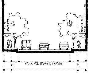
(d) Provide a 1.5-m (5-ft.) setback from the northern and southern property lines of the central avenue to give a wider pedestrian area of about 3.5 m (11.5 ft.) for the greenway, while allowing street activities (e.g. terraces, sidewalk cafés, shop display, vending).(e) Generally, building setbacks along the central avenue, beyond the required 1.5 m (5 ft.), are discouraged to create a continuous streetwall, except when they serve a useful function such as articulating a long facade, demarking an entranceway or providing additional space for outdoor seating or display.
(f) Provide a setback of up to 3.9 m (12.8 ft.) on both sides of the secondary north-south access rights-of-way sufficient to accommodate a landscape boulevard and sidewalk.
(g) When buildings are set back from streets, the landscape and architectural design should suitably maintain the continuity of the streetwall or street edge through the use of low walls, fences, mass plantings, paving treatments, etc.
3.3 Topography
Historically, the site sloped down from the south to the shoreline edge of a tidal flat. Today the site is essentially flat, reflecting the tidal flat, with a rise along Great Northern Way, where the shoreline used to be. Some cutting did occur along this edge and it is proposed to be filled in again. The new development will establish the higher existing grades along the Great Northern Way property lineas base grades and slope gradually across the site to the north and to the east, meeting the lower existing grades. This filling will generally be limited to the western end of the site where the grade differential exists.
(a) Any significant alterations of existing grade should support convenient pedestrian access to property, reflect the natural slope of the land and help visually integrate building massing into the landscape.
3.4 Building Orientation
Buildings on properties which abut the central avenue should front this road.
4 Vehicular Access, Off-Street Parking and Loading Areas
4.1 Parking Facilities
(a) All off-street parking should be generally located below grade. Some interim surface parking may be permitted on sites of future phases of development, subject to landscaped setbacks and acceptable access points as determined by the Director of Planning in consultation with the City Engineer.
(b) No parking or manoeuvring is permitted in landscape setbacks.
(c) Above-grade parking may be considered where the site slope is conducive to such a layout or if the design of the parking structure is sensitive to its streetfronting conditions. On pedestrian-oriented streets, like the central avenue, above-grade parking should be concealed behind areas containing active uses other than parking, such as building lobbies or retail services.4.2 Loading Areas
(a) Loading areas should be located within buildings or to the rear of buildings away from active streets. Access to these loading areas should be from lanes or side streets, and is discouraged from the central avenue.
(b) Loading areas should be effectively screened from view of surrounding public spaces, neighbouring properties and from the overlook of nearby residential developments, using architectural elements, such as fencing and trellises, and plant material. Screening and concealing of service and loading functions is especially critical for buildings which abut the landscape setback along Great Northern Way.
(c) Loading docks and garbage bins should not be visible from the street.
(d) Outdoor storage of goods is discouraged. When necessary, outdoor storage should be incorporated into well screened loading areas.4.3 Parking and Loading Access
(a) Where possible, access to parking structures and loading areas should be from lanes or side streets. If located along the central avenue, parking and loading should be combined into one entrance and its width should minimize interruption to the streetwall.
(b) Shared parking and loading entrances are encouraged for abutting properties.
(c) No insulation, piping or mechanical equipment is to be visible from the street unless dealt with in an architectural manner.5 Architectural Characteristics
5.1 Building Height and Views
(a) Building height limits are described in the By-law. Height limits vary across the site from 13.7 m (45 ft.) to 36.6 m (120 ft.).
(b) In addition to the limits described in the By-law, northward street-end views from St. George, Carolina, and Fraser streets should be preserved by restricting heights to 13.7 m (45 ft.) in 40-m (131-ft.) wide corridors, as shown in Figure 2. These street-end view corridors should be aligned with the centre lines of the St. George, Carolina and Fraser street rights-of-way, south of East 5th Avenue.
Figure 2 - Street-end View Corridors
5.2 Massing and Form
(a) Building massing should be broken up into smaller units that allow views through blocks or into courtyards. In blocks which approximate the scale of the existing subdivision pattern to the south, at least one break in the massing should occur and preferably more. In longer blocks over 180 m (591 ft.) in length, at least two breaks should occur and preferably more.
(b) Avoid long, continuous building forms and instead express the individual functionalcomponents of a large building complex as a series of interconnected or interrelated massings. Create identity, rhythm and variety.
(c) Respect the incremental rhythm of Vancouver streetscapes typical of mixed-use areas around the downtown.
(d) Shallow articulation of surface elements and materials is generally ineffective in achieving adequate variation in the massing and bolder manipulations of the form should prevail.
(e) Generic building designs that exhibit little facade interest or transparency should be avoided.
5.3 Building Entrances
(a) Main building entrances should be clearly identifiable, visible, transparent and accessible from the street.
(b) Pedestrian interest and comfort should be provided at entrances through specifically designed seating, signage, lighting and features that signal the building's use.
(c) Consider atrium spaces with staircases as a means to connect floors and effectively tie the entrance with the upper levels.
(d) Where possible, internal courtyards and landscaped areas should be visible from the street.
5.4 Articulation
(a) Architectural design should be expressive of the building structure of and environmental design considerations. Functional elements, such as stairwells, elevator and mechanical cores, and entrances, should be used to break up the horizontal scale of the building form.
(b) Building materials should be carefully chosen to break up the horizontal scale and accent edges for pedestrian interest.
(c) Glazing with high clarity should be used to encourage visual connections between inside and out. The use of highly reflective glazing is discouraged.
(d) Where street frontages consist of retail and service uses, they should reflect a smaller, more intimate scale and be clear-glazed to enhance openness and pedestrian interest.
(e) Design elements which contribute to energy efficiency and animate facades should be encouraged.
5.5 Weather Protection
(a) Main building entries should provide generous weather protection that is designed to be an integral feature of the building's architectural character.
(b) Building frontages along the central avenue should include canopies for weather protection.
(c) Weather protection should be considered over walkways which connect interrelated buildings, as an amenity consistent with a campus-like environment.(d) Canopies and awnings should be built of durable materials, and consideration given to lightness and translucency.
5.7 Skybridges
(a) Pedestrian bridges may be considered between the upper floors of related buildings when easing circulation, facilitating the movement of equipment and enhancing security are important aspects of a building program. Skybridges may not cross over City streets.
(b) Skybridges should have a high degree of transparency to allow views through.
5.8 Materials
(a) A consistent palette of materials should be used throughout the high-tech park .
(b) In general, all commercial-grade exterior finishing materials and details appropriate to local climatic conditions may be utilized, provided they contribute to:
i) a high-quality image that portrays a sense of permanence; and
ii) to the long-term durability of the exterior system, such that its initial integrity, quality, and visual appearance will be retained over the lifespan of the building.
(c) Materials and treatments at grade level, particularly for buildings fronting the central avenue, should present visual and textural interest at a pedestrian scale.
5.9 Roofs and Mechanical Penthouses
(a) Roofs should designed to be attractive as seen from above as well as from ground level. Large, monotonous expanses of roof should be avoided.
(b) Vents, mechanical rooms and equipment, elevator penthouses, and other rooftop devices should be integrated into the roof architectural treatment or should be grouped and screened with materials and finishes compatible with the building.
(c) Mechanical penthouses and screening enclosures should not cover more than 25% of the roof area or project more than 6 m (20 ft.) above the maximum building height. They should be oriented with the longer dimension in a north-south direction to minimize view impacts to residential developments to the south.
6 Open Space and Streetscapes
6.1 Structural Overview
A hierarchy should be established for the open space system from the public-owned and freely accessed spaces, like the street rights-of-way, to completely private and inaccessible building courtyards. In between are privately owned spaces to which the public may have some degree of access, such as the landscape setbacks. Open space is an important element which will impart the park-like ambiance desired of the high-tech campus and is one of the principal amenities sought by the worker population and the surrounding neighbourhoods. Some general guidelines for open space planning include:
(a) The landscape should be used as a unifying element for the high-tech park with a consistent system of materials and detailing used throughout.
(b) Open space intended for public use should be clearly identified and designed as such. It should have sufficient openness to be inviting and safe for the public.6.2 Streetscape design
The streets should be designed and built in accordance with Engineering Services standards and requirements. A unified system of paving, furniture, signage, lighting and plant material should used throughout the high-tech park site, with the central avenue being an area designated for special paving, lighting, furnishing and planting treatments. There are four types of streetscape treatments, as follows:
(a) Great Northern Way - Great Northern Way is to be reconstructed as a broad, landscaped boulevard with three signalized intersections, one at each end of the site and one at the centre. A landscaped median is to run its length except where there are left-turn bays for the intersections.
(b) "Central Avenue" - This central east-west spine road is a newly created street which is intended to be the internally focused "main street" for the high-tech park. It will contain most of the building entrances and addresses, and be the focus of the retail activity. It will therefore be designed to be traffic-calmed, and pedestrian and bicycle friendly. Because the central avenue is to support much of the pedestrian activity in the high-tech park, it should have a greater level of detailing and more richness of materials in its streetscape design. The central avenue is an area designated for special paving, lighting and planting treatments.
eastern section western section, one-way adjacent central open space
(c) Primary North-South Streets - The primary north-south streets will connect to Great Northern Way with signalized intersections and provide access to the central avenue with future extensions to Industrial Avenue. The easterly most street is to be build with a 29-m (95-ft.) wide right-of-way as it is to be a future extension of Industrial Avenue. The other two north-south streets are to have 20-m (66-ft.) wide rights-of-way.
(d) Secondary North-South Access - Secondary north-south access will have 12.2-m (40-ft) wide rights-of-way, and will be treated as narrow, minor streets, potentially with right-in/right-out access to Great Northern Way.
6.3 Landscape Setbacks(a) Great Northern Way - In the 9-m (30-ft.) wide setback along Great Northern Way existing mature trees should be retained where possible. Selection and placement of new plantings should enhance the existing character. A sidewalk or pathway should be provided along the length of the setback and consideration should be given to designing the path to be suitable for in-line skating, in its width, material, alignment and grade.
(b) China Creek - The 15-m (50-ft.) wide China Creek easement should be given a soft landscape treatment that is in keeping with the overall theme of the high-tech park but that also considers plant materials indigenous to local riparian environments. The landscape design should allow for future daylighting and not include large trees that would have to be removed. A pedestrianpathway should be provided along its length, with consideration given to bicycle and in-line skating access if feasible.
(c) Brewery Creek -The landscape design of the 15-m (50-ft.) wide Brewery Creek easement should commemorate Brewery Creek in a manner which is in keeping with the commemorative initiatives in the IC-3 District. It should present an attractive overlook for adjacent buildings. A pedestrian pathway should be provided along its length, with consideration given to bicycle and in-line skating access if feasible.
6.3 Central Open Space
The design of the central open space should:
(a) provide for the active and passive recreation needs of workers, visitors and local area residents;
(b) be open and inviting for the public;
(c) ensure safety and security by allowing for natural surveillance and guardianship from surrounding businesses and residents, and through the use of appropriate materials and equipment;
(d) incorporate diversity through the use of distinctive landscape materials and design;
(e) incorporate the open space into the surrounding walking and bicycling systems;
(f) consider materials, i.e. plants, furnishings and lighting, that are long-lasting and durable;
(g) maximize opportunities for users to enjoy the open space in inclement weather, for example, through dry pathways, fast-drying benches and shelters.6.4 Private and Semi-Private Open Spaces
(a) Provide clear distinctions between public and private open spaces through the use of defined access points and edges, circulation systems, grade changes and the use of plant material, architectural elements and fencing.
(b) Enhance the park-like character of the high-tech park by permitting a high degree of visual, but not necessarily physical, access into private landscaped spaces (yards and courtyards) through the use of openings in the building form, iron picket fencing, overlooks, etc.
6.5 Plant and Landscape Materials
(a) Use trees of sufficient caliper (minimum 75 mm) and height to create a reasonable impact when planted.
(b) Incorporate seasonal and coniferous planting.
(c) Avoid planting only one species of plant material except in special circumstances.
(d) Use permeable materials and natural drainage processes, including channelling, ponding and percolation.7 Lighting
Exterior lighting should be used to ensure safety and security, and to focus attention toward site and architectural features.
(a) Street lighting should be in accordance with Engineering Services standards and requirements, with a consistent and integrated system used throughout the high-tech park.
(b) Site lighting should confine the spread of light to within a development's property boundaries. Fixtures should be oriented away from public view. Lighting should be sited and specified so as to minimize direct glare impact on adjacent properties, surrounding streets and nearby residential developments. The use of concealed sources is encouraged.
(c) Short-masted and local area lighting is preferred over high-mounted, general site lighting.
(d) Pedestrian pathway lighting should be configured to primarily illuminate walking surfaces.
(e) Landscape lighting, such as uplighting of trees, backlighting of walls to silhouette trees, underbrush lighting of groundcover, is encouraged.(f) Accent lighting of prominent site features, such as ponds, fountains and works of arts, is also encouraged
(g) Entrances to buildings and dramatic multi-storey interior spaces should be illuminated to enhance their visibility and significance after dark.
8 Signage
(a) Signage should be consistent should be consistent and integrated throughout the high-tech park.
(b) A building's signage should be incorporated into its architectural design.
(c) Retail signage should be incorporated in or near the canopy, visible form the sidewalk and street, and of high quality materials.9 Environmental Considerations
9.1 Trees and Vegetation
(a) Where possible, existing trees and vegetation should be retained and protected along Great Northern Way, and incorporated into the site planning.
(b) A variety of native trees and vegetation should be provided to minimize maintenance, water use and integrate the planting design into the traditional landscape character as much as possible.
9.2 Water
(a) Permeable surfaces should be maximized to reduce stormwater runoff and recharge groundwater.
(b) Consider on-site management of stormwater runoff..9.3 Soils
(a) Topsoil should be retained, where possible, to provide a rich basis for site planting and landscape development.
9.4 Air Quality and Transportation
(a) Walking and bicycling should be encouraged by linking development to adjacent bikeways, greenways and other pathways.
(b) Convenient, safe and accessible pedestrian and bicycle connections should be provided to major bus and SkyTrain routes.
9.5 Energy
(a) Buildings should be oriented to maximize solar orientation, taking into consideration building placement and planting design.
(b) Building materials, systems and construction methods should be considered to conserve energy and reduce long-term operating costs.9.6 Solid Waste
(a) A comprehensive waste management plan should be considered among landowners that can provide recycling and reuse in close proximity by the various industrial, retail and high-tech uses.
(b) Recycling facilities should be provided for each development.9.7 Green Design Objectives
Sunshine, light, cross-ventilation, and recycled materials should all be considered in the design of buildings.
10 Crime Prevention through Environmental Design (CPTED)
The design of Great Northern Technology Park will take into consideration the principles of CPTED appropriate to an industrial and office environment. Each development proposed for the site, and the design of the public realm, should be subject to a CPTED review.
11 Phasing
The development will occur in phases. Measures should be taken to ensure each phase is completed and usable for business.
Comments from the Public, Reviewing Agencies and the ApplicantD1. Public Input
Public review of the Finning proposal was conducted in two phases, during the fall of 1998 and the spring of 1999. Two Public Information Meetings were held during each phase, one for industrial property and business owners and another for local area residents. Notification of the meetings was done through approximately 6,000 flyers mailed out to addresses in the Flats, North Mount Pleasant, Brewery Creek and City Gate, and through print ads in several local newspapers. Tenants of rental buildings along East 5th Avenue, immediately south of the Finning site, were also notified by mail notices addressed to the occupants. In addition to the Public Information Meetings, staff met on several occasions with community groups.
Public Meetings
Group Date
Public Information Meetings
Flats Business and Property Owners Nov. 26
Local Area Residents Nov. 26
Flats Business and Property Owners Mar. 16
Local Area Residents Mar. 31
Community Groups
Brewery Creek Historical Society numerous meetings, see below
Mount Pleasant Neighbourhood Association Dec. 1
Mount Pleasant Community Centre Board Mar. 10
Northern Way Housing Co-op Mar. 22Public Comment
In addition to comments voiced at the meetings, 12 written correspondences and over one hundred telephone and e-mail enquires were received. The public is generally supportive of the high-tech development concept, of adding new streets to the Flats and of providing new places of employment.
Concerns over the development were mostly expressed by residents living closest to the Finning site, along East 5th Avenue and in Brewery Creek. These residents were concerned about the height of buildings and whether their views would be interrupted, and about increases in traffic caused by the development. In response to the view concerns, the design consultants were asked to produce a detailed view analysis which gave the residents an impression of what impact the development could have from numerous view points, from both public and private locations. A building height-limit strategy was subsequently developed for minimizing view impacts and was presented at the last public meeting on March 31. Traffic impacts to the neighbourhood are not expected to be significant as through access has beenminimized. A traffic impact study is underway and further information will be available before the public hearing.
Brewery Creek Historical Society
City staff and Finning representatives met with the Brewery Creek Historical Society on a number of occasions between November 1998 and May 1999. The Society articulated their interest in seeing Brewery Creek and the historic neighbourhood commemorated in new development projects. Acknowledging the historic alignment of Brewery Creek is very important to them. They shared the successes they had so far including the commemorative cairns, the dry creekbed/native plant garden on East 5th Avenue and the plans for the St. Patrick's Church site.
Figure 1 - Brewery Creek/Finning Plan
On March 25, an informal design charrette was held to generate ideas for Finning and City owned properties in the vicinity of Brunswick/2nd Avenue and Prince Edward/1st Avenue. The historic location of the mouth of Brewery Creek is on a Finning-owned lot on the south side of East 1st Avenue, across from the rezoning site. The ideas from the charrette were then incorporated into the plan, above, prepared by Finning's landscape architects and City staff. For the rezoning site, a landscape setback or easement is proposed for along the eastern property line, the design of which would commemorate Brewery Creek with a dry creekbed and native plant material. There would be some form of public access, eventually providing a local greenway connector from the Brewery Creek Neighbourhood to the B.C. Parkway Route and False Creek. The easement would also hold in reserve land for the future daylighting of Brewery Creek. The plan was well received by the Society at their meeting of May 27.
D2. Urban Design Panel Comments
The Urban Design Panel reviewed the Concept Plan for Great Northern Technology Park on March 10 (as a workshop) and on April 2, 1999.
EVALUATION: SUPPORT (7-1)
The Panel commented as follows:
"The Panel supported this application and congratulated the applicant on a very well thought out scheme. The Panel also appreciated the thorough response to its previous comments. There were some concerns that the massing along Great Northern Way seems somewhat unrelenting, notwithstanding the proposed 25% void. One Panel member was concerned that the plan fails to reflect the ability to accommodate the very small companies that exist in the high-tech industry, noting that what is shown appears to be very large corporate style buildings.
A suggestion was made to make the Great Northern Way intersection wider to give more breathing room and provide greater visibility and focus on the central plaza. There was support for turning the grid at the central spine.
With respect to height, one suggestion was to consider shifting the mass northwards, with the south buildings at 45 ft. and increasing them to 60 ft. on the north. This would allow more light into the main spine and make it seem less overwhelming. There was support for bringing the buildings to the property line but it was also suggested that the design guidelines provide for some buffer, in places, next to the sidewalk, to make it more pedestrian friendly.
There was a recommendation for the live-work tower to be at 150 ft. so that it becomes a focus which anchors and announces the central open space, with the buildings next to it stepping down to 100 ft. As well, at the east end of the site it was suggested the south building at theentry could be lower, with the buildings at the rear going higher to serve as a visual marker and balancing the mass of the building across the street.
The Panel generally supported this application going forward as a CD-1 rezoning with design guidelines. It was stressed the regulations will need to reinforce the intent of this site being a truly urban place, quite unlike a typical suburban industrial park. Applicants should be encouraged to bring the massing up to the guideline maximum, then promoting the innovation with some other overlapping formula which allows variations in how the buildings are massed within the envelope.
It was recommended that, in keeping with this very urban, high-tech development, the approach to the landscaping should be similarly technologically advanced. The widened places with the grasses and reference to the mud flats are devoid of trees and have the appearance of suburban front lawns, whereas these places are more suitable for tree planting. Further, if the intent is for Brewery Creek to reflect the ecological health of the area it should be connected in some way so that it is ultimately allowed to merge to the other major green spaces. With the exception of one Panel member, the size of the central open space was considered to be adequate."
D3. Vancouver City Planning Commission Comments
The City Planning Commission reviewed the Concept Plan for Great Northern Technology Park on March 24 and April 21, 1999 and provided the following comments:
· Grave concerns were expressed regarding what appears to be an extreme lack of coordination between those involved in development of the Finning site, rapid transit, transportation planning and zoning.
· Concern was expressed that the timetable for the rezoning issues is far too rushed to enable good decision-making, largely due to new initiatives introduced by the Rapid Transit Project Office which may have a great impact on the process and were not available when the consultant prepared the March 1999 Concept Plan report.
· Transportation mitigation plans of other cities were discussed and could be considered. Discussions regarding the Downtown streetcar and LRT should be incorporated into the planning of this site. The link to downtown from the site is still missing from the concept.
· Concerns were raised as to:
i) how the transition from Finning would take place
ii) whether the site will be sold as parcels or as one unit
iii) how communal interests will be monitored if the site is sold as separate parcelsD4. Bicycle Network Sub-Committee Comments
The Network Sub-Committee of the Bicycle Advisory Committee reviewed the Concept Plan for Great Northern Technology Park on April 19, 1999. and provided the following comments:
· Given adequate design standards, the bicycle route should be along Industrial Avenue rather than the "east/west spine." Industrial is more direct and likely to have shallower grades.
· Changing the alignment of the west end of Industrial so that it lines up with First Avenue at the Main Street intersection is supported, as is a signalized crossing for pedestrians, cyclists and bladers at this location. However, motor vehicle access across Main Street at First should continue to be restricted to avoid east-west shortcutting.
· Construction of a bicycle path along the base of the slope of China Creek Park connecting the future intersection of Industrial and Great Northern Way with the BC Parkway bike route on 7th Avenue is supported. This path would parallel the "daylighted" China Creek.
· Roller bladers are best accommodated on an off-street path. Given the space limitations of the proposed "spine" right-of-way, it is recommended that an off-street path be considered within the 9-m landscape setback on the north side of Great Northern Way. Such a path could be shared with recreational cyclists. This path could also eventually connect to a China Creek Park link to the BC Parkway.
· The space presently available for cyclists on Great Northern Way should not be reduced in any way.D5. Applicant's Comments
Since July 23, 1998, when Council approved the Finning-funded planning process for the Great Northern Way Lands, Finning's consultants and City staff have been working together to clarify the vision of a "high-amenity, urban industrial park for high-tech uses" - a vision originally presented in the False Creek Flats Preliminary Concept Plan of June 1996.
Part of this collaborative effort involved visits to other high-tech areas to better understand the needs of high-tech industry. The easy approach would have been to identify an example of an urban high-tech industrial park and then bring those lessons home. What we learned, however, was that there are no clear examples of high-tech industry locating in a high-density, urban context. This process, then, has been a learning experience for both ourselves and City staff.
Finning is enthusiastic about the possibility of a "high-amenity, high-tech urban industrial park," though it must be made clear that Finning will not be the developer of the vision. Land development goes beyond Finning's core businesses; Finning's responsibility to its shareholders is to add value to its land assets, in this case, throughthe certainty of City land-use approvals.
It is also important to acknowledge this is the first large-scale industrial-to-industrial rezoning in recent memory. The "mega projects" have all focused on taking land from the industrial and commercial base to provide largely residential uses. While this has made an important contribution to the vitality and livability of the City, it must be noted that the "amenity standards" evolved from the previous rezonings and do not seem to acknowledge the differing cost base and the "pioneering" nature of the current rezoning proposal.
While we have enjoyed the collegial spirit of the concept plan process, there are nevertheless several significant areas where we have not yet achieved consensus with City staff. From our current understanding of the benefits and obligations, we believe the following amendments are necessary to maintain the balance in this project.
1. Parking: Staff have proposed that the recently approved I-3 amendments to the Parking Bylaw be applied to the Finning Lands. That is, a minimum of one space for each 57.5 m2 of gross floor area (1.62 spaces per 1000 sq. ft.) and a maximum of one space for each 42 m2 of gross floor area (2.21 spaces per 1,000 sq. ft.) for manufacturing; office; laboratory; production or rehearsal studio; utility and communication; transportation and storage; wholesale; and work shop.
We have many of the same concerns that Bentall articulated at the Public Hearing for I-3. That is, industrial developers in Vancouver have to compete with the much more generous parking requirements of the suburbs. As well, we note that Bentall still considered the alternative of 2.5 spaces per 1,000 sq. ft. punitive, even in the context of nearby bus lines and the proposed rapid transit station.
Given that the Finning site is not served directly or within a reasonable walking distance by transit, we believe that the I-3 parking requirements are too restrictive. To be equitable, the parking requirement of one space for each 37 m2 (2.51 spaces per 1,000 sq. ft.) that was recently granted to the Bentall site (2950 East Broadway), or as subsequently amended, is the minimum acceptable parking requirement for the Finning site.
We therefore request:
THAT the Finning Lands be granted the same parking requirement as provided to the Bentall site (2950 East Broadway).
Further, if the proposed SkyTrain station on or near the site does not materialize, we feel it appropriate to advise Council that we, or the subsequent developer, may be back to request alternate parking requirements.
2. SkyTrain: Discussions are ongoing between the City, Finning, and the Rapid Transit Office regarding the possibility of a SkyTrain station in close proximity of the site. Finning has two specific comments with respect to this proposal. First is that the preferred alignment of SkyTrain is on the Finning site, provided that the line goes underground as quickly as reasonably possible from the eastern boundary of the property and remains below the new finished grade. Second is that an acceptable alternate alignment would be along Industrial Avenue, to the north of the Finning Lands.
We therefore request:
THAT City staff be directed to communicate to the Rapid Transit Office that the only acceptable SkyTrain alignment is below the new finished grade on the Finning Lands or, failing that, on Industrial Avenue.
3. Soils Remediation: Staff have indicated that the City will require that all lands that are to be dedicated to the City (streets, open space, etc.) will need to meet a residential standard for remediation. We believe that this requirement is onerous and does not acknowledge that the zoning of the land will remain industrial, albeit high-tech industrial.
We therefore request:
THAT City staff be directed to work with the applicant to develop an alternative remediation standard that acknowledges the industrial nature of the proposed uses.
4. Building Heights: A strategy has been developed that identifies height zones that are sensitive to the views from the residential properties to the south of the site. We believe, though, that additional building height may be achieved in certain locations that will not adversely affect the overall views strategy.
We therefore request:
THAT City staff be directed to amend the CD-1 bylaw to allow for discretionary approval of building heights by the Development Permit Board or the Director of Planning, as considered appropriate, where it can be demonstrated through additional analysis that views from adjacent properties are not adversely impacted.
5. Design Guidelines: Section 5.2 of the Design Guidelines deals with "Massing and Form." The "guidelines" in this section are in our view overly restrictive - in particular, 5.2 (a) and 5.2 (b) are too specific and should either be deleted or reworded to provide the developer of the individual buildings and designers more flexibility.
We therefore request:
Staff be directed to either delete guidelines 5.2 (a) and 5.2 (b) or amend them to be more general in nature.
6. Amenities, Infrastructure, Development Cost Levies (DCLs), and Property Tax: The CD-1 plan proposes a mix of open space, greenways, and landscaped setbacks - more than one-third of the site has been set aside for green space and roads. The plan also contemplates that the developer will fund directly the on-site and immediate off-site infrastructure requirements; this is estimated at approximately $8 million. Staff are recommending that childcare and public art requirements also be incorporated into the development program.
On these latter two items, we are less certain that they have a place as a municipal requirement in a development of this nature. Our preference is that childcare and public art be provided at the discretion of the marketplace. We fully expect that a prudent developer will provide these amenities as part of the broader package, but are reluctant to make commitments for a project of a pioneering nature, where job creation is the prime objective. We acknowledge the compromise that we have reached with staff whereby the project will be reviewed at 50% build-out to determine if child care has been provided by the private sector.
Finally, it is our strongly held position, as we noted in our presentation to Council during the I-3 debate, that amenities and infrastructure costs should be paid out of the increased property taxes that the site will generate. Finning currently pays ±$700,000 per year in property taxes. We estimate that property taxes will increase to ±$10 million per year at project build-out.
We therefore request:
THAT staff be directed to review the equity of applying the current amenity standards to industrial-to-industrial rezonings as it applies to childcare and public art.
FURTHER THAT staff be directed to include increased property taxes as the basis for funding amenities and infrastructure in lieu of off-site service obligations.
Conclusion: The rezoning proposal anticipates some 6,000 to 9,000 workers in a mix of jobs and incomes. However, there are many variables that need to be balanced before success is assured or even likely. These include: land cost, the cost of amenities, infrastructure, property taxes, provincial and federal tax structures, the general livability of the City, and competition from suburban municipalities - among others. Clearly, some of these factors are beyond the scope of Council. However, we believe that Council can play an important role in rationalizing the cost of providing amenities and infrastructure with the increased property taxes that will result from the project.We thank Council for considering our position in these matters.
Applicant, Property and Development Proposal Information
Street Address
555 Great Northern Way
Legal Description
Lot D, District Lot 200A & 264A, DL 2037, Plan 13525
Lot 4, DL 2037, Plan 12165
Rem E, DL 264A & 2037, Plan 22205Applicant
Finning International Inc.
Property Owner
Finning International Inc.
Developer
Finning International Inc..
Site Statistics
Gross
Dedications
Net
Site Area
10.709 ha
3.209 ha
7.500 ha
Development Statistics
Development Permitted Under Existing Zoning
Proposed Development
Recommended Development (if different than proposed)
Zoning
I-3
CD-1
Uses
Industrial, general office
Industrial, office, retail and service, hotel, commercial live-work
Maximum Floor Space Area
321 282 m2
321 282 m2
Maximum Height
30.5 m
36.6 m
Parking
per Parking By-law
per I-3 (False Creek Flats) in Parking By-law
* * * * *

![[City Homepage]](/graphics/footnava.gif)
|
![[Get In Touch]](/graphics/footnavb.gif)
|

|

|

|
(c) 1998 City of Vancouver